Note: Descriptions are shown in the official language in which they were submitted.
METHOD FOR DETERMINING THE PRINCIPAL AXES OF AZIMUTHAL
ANISOTROPY FROM SEISMIC P-WAVE DATA
BACKGROUND OF THE INVENTION
Field of the Invention
This is a method for estimating the principal axis
of vertical fractures in fracture-induced anisotropic
media by use of compressional seismic wavefields.
Discussion of Related Art
Fracture detection is of great interest in seismic
exploration. Because of improved technology in
horizontal drilling, determination of vertical fracture
orientation is important. If fracture orientation can be
measured from seismic data, horizontal boreholes can be
directed perpendicular to the fractures for maximum
hydrocarbon recovery. Vertical fractures are formed in
relatively brittle subsurface earth formations due to
folding stresses. A typical example is the fractured
Austin Chalk which underlies the Taylor shale
formation.
It is well known that vertical fractures in an
otherwise isotropic rock will induce angular or
azimuthal anisotropy in the fractured medium. By
definition, in an isotropic medium, the velocity of
propagation of an acoustic wave is the same along all
three spatial axes: x, y, and z. In an anisotropic
medium, the acoustic velocity is greater along one axis,
termed the principal axis, than it is along the other
two axes. The velocity increase may be due to a change
in the elastic constants of the rock such as that due to
a change in cementation, particle size, composition,
1
CA 02150493 2000-02-16
depth of burial, fluid content, structure and other
factors. Commonly, the principal anisotropic axis is
along the vertical or z axis. Lateral anisotropy along a
substantially horizontal axis sometimes is observed on a
broad regional basis but that change is gradual and of
little concern on a local basis.
As stated earlier, vertical, oriented fractures in
an otherwise isotropic medium induce significant local
lateral anisotropy field. The propagation velocity of a
wavefield varies with the ray-path incident angle and
the lateral angular direction of wavefield propagation
relative to the strike of the fracture zone. The
velocity of an acoustic wavefield is greatest along a
direction parallel to strike and is least when the
wavefield trajectory is perpendicular to the plane of
the vertical fracture zone.
An explanation of the physical reasons for that
effect may be found in US patent 4,817,061 which issued
March 28, 1989 to R. M. Alford et al._
In that patent, polarized shear wave
surveys are performed to determine azimuthal variations
in the earth's subsurface caused by fracture orientation
and density. The surveys may be done by using the same
polarization (either horizontal or vertical) for the
shear waves along two different seismic lines of profile
or by using two different polarizations along a single
common line of profile. The survey data can then be
processed and compared: any difference constitutes a
measure of fracture orientation and density. That
patent, however, teaches away from and specifically
dismisses use of compressional or P waves for vertical
fracture studies.
The method taught by the '061 patent has the
serious disadvantage that multicomponent sources and
receivers must be used in order to generate shear waves
having the required polarization. The drawback is
2
215 ~ 4 9'~
particularly disadvantageous in the case of sources
because two separate vibrators must be used to generate
horizontally-polarized shear waves and vertically-
polarized wavefields, each vibrator costing several
megadollars.
US patent 4,571,710, issued February 8, 1986 to N.
S. Neidel et al for a Seismic Method for Identifying
Low Velocity Subsurface Zones, teaches a method which
uses seismic data having different directions of
propagation through a common subsurface anomaly to
measure the interval velocity variation within a
selected formation interval, using moveout-derived
velocities as a function of direction. A velocity
variation is taken to be qualitatively diagnostic of
porosity.
The '710 patent is of limited use for qualitative
measures of porosity but the method is not uniquely
indicative of vertical fracturing.
In an effort to reduce the high cost of the sources
needed for the '061 patent method, Mallick and Frazer
suggested use of converted waves from P-wave data in a
paper entitled Reflection/Transmission Coefficients and
Azimuthal Anisotropy in Marine Seismic Studies,
published in the Geophysical Journal International, v.
105, pp 241-252, 1991. Using converted wave data does
indeed provide a cheaper alternative to a multicomponent
wavefield source. But the signal-to-noise ratio in
converted waves data is usually very low which causes
serious errors in predicting the fracture orientation.
Moreover, the method requires dense
3-D multicomponent recording resulting in an extremely
large volume of data that needs to be processed as well
as new interpretation techniques that have not yet been
fully developed by the seismic industry.
3
SUMMARY OF THE INVENTION
Herein is taught a method comprising the steps of
emitting a compressional wavefield into the earth from a
source, for insonifying the subsurface earth layers to
generate reflected wavefields after reflection of the
wavefield from the respective subsurface earth layers.
The reflected wavefields are received by seismic sensors
that are distributed along a first and a second line of
survey, each line having a known orientation. The
received reflected wavefields are recorded as first and
second discrete time series that are then formatted as
first and second CMP data-sample gathers. Within a
selected time zone from the first and second CMP data-
sample gathers, a first and second average amplitude
vector is determined. The first and second average
amplitude vectors are resolved with the known
orientations of the lines of survey to estimate the
azimuth of the principal axis of anisotropy.
In an additional aspect of this invention, seismic
sensors are distributed along a third line of survey
established that has an orientation that approximately
bisects the orientations of the first and second lines
of survey. Reflected wavefields detected by the seismic
sensors along the third line of survey provide the data
for defining a third amplitude vector which may be used
to improve the accuracy of the resolution of the
principal anisotropic axis.
BRIEF DESCRIPTION OF THE DRAWINGS
The novel features which are believed to be
characteristic of the invention, both as to organization
and methods of operation, together with the objects and
advantages thereof, will be better understood from the
following detailed description and the drawings wherein
the invention is illustrated by way of example for the
purpose of illustration and description only and are not
intended as a definition of the limits of the invention:
4
FIGURE 1 is a quasi-perspective view of a
vertically-fractured formation;
FIGURE 2 is a plan view of a seismic source-
receiver array with the receivers distributed along
three lines of survey, one line of which is oriented at
an angle ~ with the average strike of a fracture
pattern;
FIGURE 3A illustrates the amplitude variation as a
function of offset for a wavefield trajectory that is
parallel to the strike of a fracture pattern;
FIGURE 3B illustrates the variation of amplitude as
a function of offset for a wavefield trajectory that is
at an angle of 45° to the strike of the fracture
pattern;
FIGURE 3C illustrates the variation of amplitude as
a function of offset for a wavefield trajectory that is
at an angle of 90° to the strike of the fracture
pattern:
FIGURE 4 shows the amplitude variation as a
function of azimuth for three different source-receiver
offsets:
FIGURE 5 is a graph of the variation of normalized
P-wave amplitude as a function of angle of incidence for
various relative azimuths;
FIGURE 6 is an empirical graph, for a selected
area, of the in-line versus cross-line normalized
amplitudes for seven line orientations with respect to
the strike of a fracture pattern;
FIGURE 7A is a graphical representation of sample
amplitudes for a portion of a discrete time series;
FIGURE 7B is the discrete time series of FIGURE 7A
rectified and amplitude modulated; and
FIGURE 7C is the time base for the discrete time
series.
5
CA 02150493 2000-03-10
this disclosure, the term "signature" means the aspect
of a waveshape, expressed in terms of a magnitude as a
function of time, that makes it distinctive.
Using an iterative summation/auto-correlation
technique taught by US patent application 08/101,949,
earlier cited
determine the scale factor, k, for scaling
the average geophone signal amplitude to the hydrophone
signal amplitude. In the absence of other noise
abatement processing, the normalized summation of the
gathers is E(') - ~(H + k*G).
The method for determining the scale factor, k, may
be summarized as follows: The hydrophone pressure
signature is filtered to create a best estimate of a
geophone velocity signature. The estimated geophone
velocity signature is subtracted from the real geophone
velocity signature plus embedded noise to yield a nearly
pure noise signature. Now, the noise signature is
subtracted from the real geophone velocity signature to
provide a clean geophone velocity signature. A scale
factor is iteratively applied to the clean geophone
velocity signature, summed with the hydrophone pressure
signature and auto-correlated. A measure of the scale
factor is suitably determined from a study of the main
lobe and the first side lobes of the autocorrelation
trace. The iteration progresses until a suitability
measure is maximized.
Within a fixed analysis window such as 14 from the
hydrophone traces of Figure 2, the detected pressure
signatures are grouped together to form a first, common
hydrophone gather. Within a fixed analysis window 16
from the velocity-receiver traces of Figure 3, the
geophone signatures are grouped together to form a
second, common geophone gather. The measured average
trace amplitudes of the geophone signals relative to the
hydrophone signals in the fixed analysis window are used
to define the ratio R1.
6
~1549~93
intervals in a grid-like pattern over an entire area.
Virtual lines of survey may be established along any
desired wavefield-trajectory azimuth by selecting for
processing, data from receivers that happen to reside
along that desired azimuth but without the need for a
formal line layout.
As is well-known and as explained in the '061
reference, in the case of a vertically-fractured
formation, the propagation velocity of P waves is
greater traveling along a trajectory parallel to strike,
the principal anisotropic axis, than along a trajectory
that is perpendicular thereto. Such a formation
therefore exhibits angular fracture-induced anisotropy.
Given two or more lines of survey having known azimuths,
the strike of the fracture pattern should be
determinable by resolving the velocity vectors along
each line. In practice, it is difficult to numerically
resolve the velocity differences due to angular
anisotropy so that method is usually not very useful.
The amplitude of a reflected wavefield depends on
the contrast in acoustic impedance at the interface
between two media which, in turn, is a function of the
velocities and densities of the two formations.
We have found that the reflection amplitude-vector
variation as a function of azimuth, for a fixed offset
(separation between a source and a receiver), may be
resolved about the known orientations of the lines of
survey to quantify the angular anisotropic variation due
to fractured formations.
Figures 3A, 3B and 3C are synthetic seismograms
showing the change in reflection amplitude as a function
of three different angular orientations of the wavefield
trajectory relative to the strike of the fracture
pattern, namely 0°, 45° and 90°. The first event, 37, on
each seismogram is the P-wave reflection, the second
event, 39, is a mode-converted P-S wave, which, insofar
as this invention is concerned, is not of interest.
7
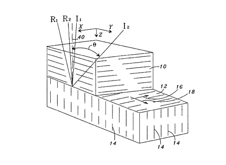
It is to be observed that, for offsets up to about
600 meters, the reflection amplitudes in Figures 3A, 3B,
3C remain substantially constant for all three azimuths.
For 0° azimuth, the reflection amplitude remains
constant for all offsets (the data have been normalized
for spherical spreading). But beyond about 550 to 600
meters, the reflection amplitudes progressively diminish
with increasing offset as the wavefield trajectory
rotates to become perpendicular to the fracture plane.
For an explanation, let us refer back to Figures 1 and
2. Assume a wavefield trajectory emanating from source
30 along line 22 of Figure 2 towards sensor 32. For a
receiver near source 30, the wavefield raypath I1-R1
would substantially coincide with line 40 of Figure 1,
the normal to the interface of formation 12 and
substantially parallel to the vertical fracture plane
and therefore that portion of the wavefield would see a
relatively high velocity at the point of incidence. A
wide-angle ray path such as from source 30 to receiver
32 of Figure 2 along raypath I2-RZ of Figure 1, which
constitutes a wavefield-trajectory that is substantially
perpendicular to the strike of the fracture pattern,
becomes much flatter and sees the lower velocity that is
characteristic of a wavefield propagating broadside to
the fracture plane.
Thus, we have found that there is a significant
variation of the amplitude vector as a function of
azimuth for wide angle reflections having an incident
angle B on the order of 20° or greater where a is
defined as the incident angle between incident ray I and
the normal, 40, to the interface between formation 10
and 12. That effect is clearly shown in Figure 4 which
illustrates the change in normalized reflection
amplitude as a function of the azimuth of a wavefield
trajectory for three different offsets. Figure 5 is a
graph showing the variation of the normalized reflection
amplitude vector as a function of angle of incidence for
8
215Q4~3
lines of survey having five different relative azimuths
with respect to the strike of the vertical fracture
plane of a target formation.
We have found that the P-wave reflection amplitude
vector u, for a fixed offset, can be expressed as
a = A + B cos 2~, ( 1 )
where cp is the angle between the azimuth of the
wavefield trajectory and the strike of a vertical
fracture plane, A is an offset-dependent biasing factor
and B is an offset-dependent amplitude modulation
factor. A solution for ~ may be formulated as follows:
Assume that for every common midpoint gather (CMP)
we have three lines of survey oriented along three
different azimuths, ~, ~+a, ø+R, a being the angle
between a first and a second line such as 22 and 24 of
Figure 1, R being the angle between the first and a
third line such as 24 and 28. The corresponding
amplitude vectors ul, uz, and u3 can be resolved around
the three azimuths to solve for ~, the angle between a
first line such as 24 and the principal anisotropic
axis, that is, its strike as follows:
ul = A + B cos 2 ~, (2)
u2 = A + B cos 2 (~+a) , ( 3 )
u3 = A + B cos 2(~+R). (4)
Subtracting (3) from (2),
ul - u2 = 2 B sin(2~+a) sin a (5)
and similarly for (2) and (4),
ul - u3 = 2 B sin(2~+p) sin R. (6)
Combining (5) and (6) and solving for ~,
~ = 2 tan-1( [ (ul-u3) sinz a - (ul-u2) sine Rl
9
21~U49~
[ (ul-u2) sin R cos R - (ul-u3) sin a cos a] } ~ Zn~r, (7)
for n=1, 2, 3, ... etc. The ui are the average amplitude
vectors for selected time zones as measured from the
appropriate CMP gathers for each line of survey.
In the special case where two lines such as 22 and
24 are orthogonal and a third line 28 substantially
bisects the angle between the first two lines, then (7)
simplifies to
tan-1 [ ( ul + u2 - 2 u3 } - ( ul - u2 } J ~ 2 nor . ( 8 )
Suppose there is a 3-D seismic survey where there
is in-line and cross-line data for every CMP gather.
Determination of fracture orientation from those data is
an undetermined problem. Consider the in-line direction
is oriented at an arbitrary angle ~ to the fracture-
plane strike. From (1), the in-line amplitude response
ul and the cross-line amplitude response u2, at a fixed
offset can be expressed as
ul = A + B cos 2~ ( g )
and
u2 = A - B cos 2~. (10)
Adding (9) and (10)
ul - u2 = 2B cos 2~. (11)
Since the offset-dependent amplitude modulation
coefficient B of (11) is not known, that formulation by
itself is insufficient to determine the orientation of
the anisotropic axis. From experience in the area, in
Figure 6 an empirical graph may be constructed showing
the normalized in-line amplitude vectors versus the
normalized cross-line amplitude vectors for different
values of orientation angle ~ of the in-line direction
with respect to the anisotropic axis such a the vertical
fracture plane. The equation of the best-fitting
straight line for a given curve in Figure 6 is
G = 1.0 + b cos 2~, (12)
2~.~0 X93
G being the slope and b the intercept of the selected
curve. Thus
uo = -b cos 2~, ( 13 )
whence
~ = Z cosm
[(G-1) / b], (14)
and from ( 13 )
= cos-1 (- uo/b) - (15)
In equations (12) - (14), the intercept, b, appears to
be dependent upon the degree of azimuthal anisotropy as
induced by the fractures. In that circumstance, b is an
empirically-determined elastic modulus that depends upon
the fracture density. Therefore by calibrating the
fracture densities equations (14) or (15) can be used to
estimate the fracture orientation from the in-line and
cross-line P-wave amplitude vectors. Those equations
require use of prestack data. In the post-stack domain,
G ~ u2 / ul, so that
2 cos-1 { [ (u2 / ul) - 1] . b} . (16)
As explained earlier, seismic data are customarily
recorded as discrete time series of digital data
samples. In operation, the discrete data samples
received and recorded for each receiver are stacked to
form common mid point (CMP) gathers for the in-line and
cross-line components in a conventional, well-known
manner. Figure 7A shows a short portion of a time series
between reflection times of 1.5 and 1.7 seconds, the
amplitudes and polarities of the discrete data samples
being indicated by the length of the corresponding short
vertical strokes above and below the zero axis 43. The
time scale is indicated at Figure 7C.
For purposes of this disclosure, the values of the
discrete data samples that make up each CMP gather are
rectified, such as by taking absolute values as shown in
Figure 7B. The rectified data samples are amplitude-
modulated to form an average amplitude envelope 42 as
shown in Figure 7B. The amplitude vectors ui are then
picked off the amplitude envelope within a time window
11
215 ~9~
embracing a selected reflection time-zone such as
between the dashed lines 44 and 45 that corresponds to a
target subsurface earth layer. The selected time zone
includes reflection data originating from at or near the
interface between a fractured formation of interest and
a preferably isotropic layer next above. If the next
overlying layer is itself anisotropic, the reflection
data must be corrected for the residual anisotropic
geometric spreading due to the overlying layer.
This disclosure has been prepared with a certain
degree of specificity by way of example but not by way
of limitation. The method has been explained herein with
reference to the determination of the azimuthal
alignment of vertical fracture zones. The method may of
course be applied to the study of any type of lateral
angular velocity variation due to any petrophysical
process such as but not limited to the processes listed
in the introduction to this disclosure. This invention
is limited only by the appended claims.
12