Note: Descriptions are shown in the official language in which they were submitted.
CA 021~83~ 1998-07-02
AUTOMATIC VEHICLE CONTROL AND LOCATION SYSTEM
The present invention relates to signaling and traffic control systems, and
particularly to a railway ~ign~lin~ and traffic control system wherein a unique vehicle-
5 based topographical database combines with a wayside-based signaling means to provide
vital control of each respective vehicle traveling along the guideway.
BACKGROUND OF THE INVENTION
0 Various systems have been designed to allow automatic (driverless) operation of
rapid transit vehicles in m~inline revenue service (i.e., passenger carrying operations)
using either fixed block or moving block designs.
In a fixed block design the guideway is divided into segments called blocks.
In the system briefly described in U.S. Patent No. 4,166,599, block boundaries are
identified by short vertical strokes through the horizontal line identifying the guideway.
An apparatus is arranged in each block, for detecting the presence of a vehicle in that
block. This wayside apparatus may be coupled to wayside appal~Lus of one or moreadjacent upstream blocks for the purpose of informing vehicles in such upstream blocks
of the presence of a vehicle in a downstream block. In one specific application, for
example, the block directly upstream of an occupied block is provided with a signal
requiring an emergency stop. The next adjacent upstream block is provided with a signal
requiring a stop, the next adjacent upstream block is provided with a signal calling for a
2s low speed, and so on. In effect, an information communication arrangement is combined
with distributed wayside data processing or computing. In such a system, the vehicle
headway, i.e., the distance between moving vehicles, is at least one block long, and may,
CA 021~83~ 1998-07-02
in normal practice, be two or more blocks long. Fixed blocks have the disadvantage of
not providing maximum performance and cannot be easily overlaid on existing track
circuits. They do, however, have the advantage of a distributed architecture.
s In the moving block design each vehicle that is being controlled, transmits its
location to a controlling authority, usually on a periodic basis. Thus, the controlling
authority has available to it information as to the location and, perhaps speed, of all the
vehicles being controlled. Under these circumstances, the controlling authority then
provides signals to the vehicles, based upon downstream traffic conditions, allowing the
o vehicles to proceed at safe speeds, or on the other hand, requiring the vehicles to stop.
Moving block systems improve performance but are highly centralized, leaving
availability and start-up problems.
A third method for automatic (driverless) operation is also set forth in U.S. Patent
No. 4,166,599. This patent discloses a control system in which each vehicle has provided
to it information regarding the next adjacent downstream occupied or unavailable block;
the system relies on distributed (i.e., vehicle carried) data processing or computing. This
system avoids the need for multiple communication channels required by the conventional
moving block approach. At the same time, however, the single communication channel
may provide to any vehicle the identity of the block it occupies, the identity of the next
adjacent downstream occupied or unavailable block, and the speed of the vehicle in such
block. With this information, the upstream vehicle's headway can be reduced to approach
the headway achievable in moving block systems.
WO 94/22704 21 5 ~ 3 ~ ~ PCT/US94/03527
The p, h"a, y objectives of designing a new railway ~i~n~lin~ and traffic control
system are to achieve a system which is flexible and capable of optimal pacse~ er
throughput. Optimal pA~senger throughput can be obtained by l~..n....;,.;..g vehicle
headway and ",ax;,..;,.;i~g p~cs~ns~el management. These systems must be colllpalil.le with
5 driverless operation and with automatic operation which employs various levels of driver
intervention.
It is also a goal that such systems be applicable as an overlay to e,.isling systems to
provide various levels of upgraded operation. To achieve this goal, a system must be
l 10 capable of being applied in a modular fashion to meet the current needs of a particular
system operator while being capable of expansion to a higher degree of automaticoperation.
Any new system design should also ...in....;~ç the required wayside hardware,
115 in~t~ tion and testing time and ...,.x;...;~e the system reliability and availability. In
addition to redund~ncy (hot standby) capabilities, high system availability can be achieved
by dçsigning a system which has clear fall back op~l ~ling modes in the presence of failures.
The major obstacles to h~pl~ ing co"")l~ e vehicle carried systems are vital
120 methods of having vehicles determine the position of vehicles in front of them and of
vehicles vitally controlling switches and routes without vital wayside help. The present
invention which uses carborne intr.llig~nce in the form of a topo~h ~l map d~t~h~ce
l,~nsr~,~ a subst~nti~l amount of vehicle control and position or location d~le,l"",alion
respons;l,ilily to the vehicle-based equipment, thereby reducin~ the hlrullllalion which is
l 25 required from the wayside-based equipment.
WO 94/22704 215 ~ PCT/US94tO3527
In general the present invention provides a railway cign~ling and traffic control
system design which centers around the use of communicating vital i"ro~ ~"alion between
the wayside and the vehicles and the use of an onboard topographic d~t~b~ce. With each
vehicle co.,l~ining a vital d~t~b~ce which lepresellls the system topology the system is
5 designed to be very flexible with a minimllm of wayside hardware. One major advantage
of this scheme is to concentrate the majority of the equipment with the vehicle, which
allows equipment preventive m~intçn~nce to be accompliched at a central location.
Thel erore the present invention provides the pe,~o",.ance advantages of a moving block
system, while ll~ h~ a distributed architectllre to provide reliable and available
0 service such as that provided in fixed block systems.
The present invention also provides many additional advantages which shall
become apparen~ as desclil,ed below.
SUMMARY OF T~E INVENTION
A railway .cign~ling and traffic control system which comprises: a vehicle-basedcontrol means capable of dete"",l~ g the position of a vehicle as it traverses along a
guideway, the vehicle-based control means inclutlin~ an onboard computer means with
20 both a topographical d~t~b~ce and a vehicle ~l~t~b~ce desv,ibillg vehicle pe,~"..ance (e.g.
braking rate profile), means for measuring the speed of the vehicle and the llict~nce which
the vehicle has traveled; wayside control means disposed within each sector of the
guideway, the wayside control means capable of communicating with all vehicles within its
sector of control and with other wayside control means outside its sector of control; means
25 for communicating from the vehicle to the wayside control means and from the wayside
control means to the vehicle; a plurality of vehicle location inro",lalion means disposed
along the wayside, or guideway, for lla~lclll~ g location h~o-",alion to the vehicle
wo 94/22704 21 S 8 3 S ~ PCTluss4lo3s27
location detection means, so that the vehicle can determine its own absolute position;
means for communicating from each vehicle location detection means to the vehicle
control means; and means for controlling the speed/stopping profile of the vehicle in
accordance with inputs received from the onboard computer means the inputs being5 generated based on inro""alion co"lained in the topographical d~t~b~e vehicle
pe, rO. ~-,~lce d~t~bace and the means for measuring the speed of the vehicle and the
di~t~nce which the vehicle has traveled.
The means for communicating belween the vehicle and the wayside control means
0 is a vehicle-based l~S1n.~ e~ /recei~rer means and a wayside-based l,;~n~-,;l ler/lecei~rer
means. The vehicle-based and wayside-based l,an~ ;cei~er means incll~de7 forc ~ lpl~ ntenn~ However alternative communication techniques known to those of
ordh~a,y skill in the art are also contemplated hereby.
The topographical d ~IAbA~e incllldes guideway Chd~ ltli~iCS and fixed obstacle
locations. The vehicle performance d~ bA~c incllldes vehicle characteristics.
The wayside control means co"""ises: a power source; means for receiving vital
inputs (e.g. on interlocking controller) means for Clealing a source of vital energy for
setting vital outputs to a safe state in the event of a failure; means for vitally setting
outputs; a microprocessor for processing the vital inputs; means for encoding and
decoding the vital mess~es to/from the vehicle-based means; means for l,~n~l--;ll;,~g and
receiving communications from other wayside control means; means for receiving non-
vital inputs; means for l~an~ l;ng the non-vital inputs to a microprocessor for processing
thereof; and means for storing data.
wo 94/22704 21~ ~ ~ i S PCT/USs4/03527
The vehicle-based control means further con""ises: a power source; means for
receiving vital messages from the wayside eqwpment via a data communications link (e.g.,
R.F. ~ntçnn~); means for detell"ming the vehicles absolute location (e.g. beacons); means
for genel ~ling a stopping profile speed limit based on topographical data and vehicl
5 parameters or characteristics; means for vitally reading inputs and setting outputs; means
for creating a source of vital energy for setting vital outputs to a safe state in the event of
failure; and a means for el~l~ g speed limit versus measured speed.
When the vehicle location h~l",a~ion means uses a beacon system to determine
10 absolute position ofthe vehicle, then such means further co~ "ises: means for receiving
communications from the beacon means; means for decoding the co,l~,lullications from the
wayside beacon means; and means for l~i.n~ g the communications received from the
beacon means to the onboald computer means. A typical embodiment of a beacon uses a
passive 1, ~ns~ onder which is encoded with a unique code. The wayside beacon is excited
15 by R.F. or inductive energy from the vehicle beacon reader and responds with its unique
code mod~ fing a R.F. signal.
Other and further objects, ad~"l~es and features of the present invention will be
understood by reference to the following speGificafion in conjunction with the ~nneYed
20 drawings, wherein like parts have been given like numbers.
BRIEF DESCRIPTION OF THE DRAWINGS
Fig. l is a sche",alic diagram of the wayside control means used in accordance
25 with the present invention; and
WO 94/22704 21 5 8 ~ 5 5 PCTIUS94/03527
Fig. 2 is a sçh~m~tic r~rese ~ on of a vehicle-based location control system in
accordance with the present invention;
Fig. 3 is schen-~tic, epresenla~ion of a wayside-based sign~ling and traffic control
5 system in accordance with the present invention;
Fig. 4 is a sç~l~m~tic diagram of the vehicle-based control means used in
accordance with the present invention.
DESCRIPTION OF THE PRE:FERRED EMBODIMENTS
A railway ~ gn~ling and traffic control system capable of dele"""~lg a vehicle'sabsolute position or location (based on i"ro""alion received *om the fixed wayside
reference using an inductive loop or beacon system in conjunction with the J;sl~ 1ce
5 traveled according to the onbo~d tach generator(s), report its position to the wayside
control means and the wayside control means will report to the vehicles, as part of its
communications mess~e, the location of the closest forward obstacle. This obstacle may
be an unlocked switch another vehicle, etc.
The vehicle onboa,d int~llig~nce, using a system or topographical ~ h~e in the
form of tables, allows the vehicle to determine the di~t~nce b~l~.een itself and the nearest
obstacle. With this i,~""alion the vehicle will generate a safe speed limit profile inclllding
any civil speed restrictions andlor station stopping points to bring the vehicle to a safe stop
short of the obstacle or in the station.
This intelligent railway sign~ling and traffic control system requires the following
major subsystems: a vital communications system be~ee" the vehicle and wayside, a vital
WO 94/22704 21~ ~ 3 5 5 PCT/US94/03527
carborne profile generation/automatic tram protection (ATP) system, a vital carborne
topographical intelligence, wayside béacons or other location system, a vital wayside
means of determining next forward obstacle for each vehicle. In addition, an optional non-
vital hlrolnlalion system can be incoJ,uolaled into the system.
The onboard system topograhical data base, as illustrated in Fig. 2, can be used to
generate civil speed restrictions (in~lu(ling those necess~ry for reverse switch moves) and
station stopping points. A typical vehicle 2 will include an automatic train controller 4,
i.e., a microprocessor, which has been pre-progl~ullmed with a topogl~ph;cal d~t~h~e 6
10 COIIIIJ- ising a table of fixed map pal ~.,lelers 8. The fixed map pa,~,lelers 8 may include
the grade of the track, the switches along the track, the civil speed limits about the track,
location of wayside beacons, loops and station locations. Using the topographical data
base, and actual speed ofthe vehicle as detellllil ed by one or more onboard tachometers
12, the automatic train computer allows precision station slopping, speed profiling and
15 door control at each station. Each vehicle 2 also in~ludes an RF ~ntPnn~ 14 and loop
~ntçnn~ 16 to lransmil and receive communications to and from wayside-based equipment.
Each vehicle also includes a beacon antenn~ or loop antenn~ transition detector for
g absolute vehicle position.
The onboard ATP equipment utilizes the topographical data in conjunction with
the wayside ~ led h~llllalion regarding switch positions and the location of other
vehicles or obstacles in its directional path to generate a speed/stopping profile. This
profile will bring the vehicle to a stop before it reaches the closest obstacle or at the
correct position in a station plalr~lll- taking into account the vehicle minimllm design level
braking characteristics and the grade of the directional path. The system also allows for
central control to modify train schedules.
WO 94/22704 21 5 ~ 3 ~ ~ PCT/US94/03527
-
The functions of the wayside-based equipment (i.e., wayside control means and
vehicle location hlrol "~alion means) are to control switches, obtain and ll ~h~lllil the
locations of vehicles in the control se~em~nt~ hand the vehicles offbetween control
segments, and interface with the central control office. The vehicle location inîoll"alion
5 means (beacons or loop transitions, for example) provides an absolute location reference
system that the vehicles can use to update their positions. The vehicles will keep track of
their position between these absolute l~rellces using one or more onboard tachometer(s)
and/or the control section IDs provided by the wayside communications.
0 Communications from the wayside-base equipment to the vehicle may include:
sector or ~ntçnn~ ID, vehicle ID, obstacle location, switch position and ID or route,
proceed pelll..ss;on, travel direction, open doors, hold with doors open, change vehicle
olienlalion/direction, and non-vital m~n~g~ nt and control il~olnlalion.
Communications from the vehicle to the wayside control means may include:
vehicle ID, control unit location, train length, train location, travel direction, train speed,
train status, non-vital m~n~ment and control il~"l,alion, and route cancel request
accepted.
Communications from one wayside control means to another wayside control
means may include: sector ID, position and status of ~wilches or routes, routes that are
free, status of turnback operations, list of trains which have çhe~ed in but were not
handed off ID of train being handed off, route ç~ncçled and non-vital m~na~ement and
control il~olmalion.
~ Communications from wayside control means to a central control office may
include: train positions and IDs, traffic direction, route status, status of vehicle and
WO 94/22704 21~ 8 3 5 5 PCT/US94/03527
wayside systems station conditions, schedule modifications/time adjusllllt;llls, and non-
vital m~n~Çm~nt i,~""alion.
There are two pr~rt;~, ed types of data links which make up the vehicle to wayside
5 communication means which provides the vehiclè'with absolute vehicle location
h~ro""alion on a routine basis. The first type is an inductive loop system. The most
general wayside location for an inductive loop antenna system is mounted between the rails
or on the running surface of the guideway. Other locations (such as third rail cover, tunnel
wall or ceiling, etc) are possible but depend on the configuration of the vehicle and
10 guideway. The frequency range of the loop signal is typically in the 1 Khz to 300 Khz
range. The inductive loop functions as a large single turn l,~n~ru"l-er winding (~ntçnn~)
on the vehicle.
The vehicle ~nt~nn~ for a track mounted inductive loop system is mounted to the
15 underside ofthe vehicle such that the vertical d;~ ce from the wayside loop controller is
typically less than 25 cm.
The second type of data link uses radio frequency (RF) communications belween
the vehicle and the wayside. There are two basic forms; communication between a point
20 vehicle ~ntçnn~ and communication belweell a point vehicle antenn~ and a linear wayside
~ntenn~ ( e.g. Ieaky coax).
There are also two plerelled types of vehicle location i,~l",alion means. The first
is based on the use of the inductive loops described previously. A unique ID broadcast
25 through the loop provides gross location i"~""alion while the vehicle obtains the fine
location il~""alion by counting phase shi~s due to loop transitions on the wayside.
WO 94/22704 215 ~ 3 ~ ~ PCT/US94103527
'_
The second vehicle location inrol,llalion means is a beacon system. The beacon
system is a radio-based communication link which uses radio frequency (RF)
communications be~wt;ell the vehicle and the beacon. A typical beacon is a passive
transponder, encoded with a unique ID, excited by RF energy from a vehicle based5 interogator (beacon reader). Onboard tachometers may be used to provide fine location
in~ lalion between the beacons.
A typical in~t~ tion would use RF communications for the wayside to the vehicle
communication means along with beacons for vehicle location inrolll,alion means or it
0 would use inductive loops for both wayside to vehicle commllnic~tion means and vehicle
location hlrolllla~ion means.
It should be appalell~ that a wide variety of communication means and vehicle
location inrolllla~ion means can be used as alternative to these pre~lled types. This train
15 control system is a tMin oriented block system (i.e., moving block). The system requires
vital two-way data comm-lnic~tion b~ween the wayside and the vehicle, and b~lweell
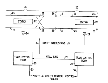
adjac~nt control sectors. As shown in Fig. l, the wayside is olgdlliLed into control sectors
25. A sector may include all tracks (both directions) centered on a wayside station
location, be divided into a sector per track 21, or include several stations 22 per sector.
20 This is dependent on the design of the communication ~ntenn~ structure 24, the complexity
and number of interlockings, the headway re~luhelll~ s, etc. Train control room 20
controls the communications to vehicles, the ali~nlent of interlockings within the sector
(route control), and station interfaces within the sector. Each train control room 20 is in
communication with adj&cçnt train control rooms by means of vital comrnunication links
25 28 (e.g., a twisted pair of fiber optics). Moreover, each train control room 20 is in
communication with a central control office, not shown, via non-vital communication link
30 (e.g., a fiber optic).
WO 94/22704 215 8 3 S ~ PCT/US94/03527
-
Fig. 3 is a schematic replesenlalion ofthe plcrt;lled wayside control means ~llelei
a wayside antçnn~ 24 is connected to a vital CPU mess~e encoder/decoder 40 via
coupler/isolator 42 and ~ s..,;ll~r/receiver 44. Thereafter, encoder/decoder 40 is
connecled via system bus 46 in a bidirectional relationship to a vital logic processor 48, a
source of vital energy (VPC/VRD) 50, wayside communications control 52, non-vital logic
CPU 54, data logger CPU 56, vital input and vital output. VPC/VRD 50 provides vital
output energy to vital outputs 60. In the event of an unsafe failure, vital energy is
removed from vital outputs 60 causing them to go to a safe state. Vital input unit 58
lo receives inputs from interlocking controller unit 62 (e.g., relay interlockings). If an
electronic interlocking, such as a VPI(~) (vital Processor Interlocking), m~nl-f~ctured by
General Railway Signal Co,l,o~ion, is used, the vital data is ll~sr~"ed via a serial
communications link into the communication controller 52. The entire wayside control
means is pr~rt;l~bly poweled by a DC/DC power supply 64. Non-vital logic CPU 54 is
colme~;led to non-vital inputs 66 and non-vital outputs 68 via non-vital I/O bus 70. This
wayside sector controller is co.~ led to other wayside sector controllers and a central
office via communication controller 52 and a central comm~mications link 72, dowll~lle&,
communications link 74 and upslle&~ll communications link 76.
The vehicle-based control means is shown in Fig. 4 and in~l~ldes an ~ntenn~ 14
which is capable of l,~.-~,..;l~;,-e and receiving signals to and from wayside ~nt~nn~ 24.
Antenna 14 is conne-;led to a vital communication processor modem 80 via
coupler/isolator 82 and lli~n.~...;llel/lt;cei~rer unit 84. Vital communication processor 80
provides next obstacle h~rc,l ",alion to the profile gent;, alor 100 and non-vital m~ ges
25 (e.g., SCADA, ATO, vehicle health) to non-vital system 102. The location dete"l,il,alion
function of non-vital system 102 determines absolute location via, for e,.~"ple, beacons
and tachometer pulses. Alternative methods of location d~t""in&lion can also be used
wo 94/22704 21~ ~ 3 ;) ~ PCTluss4lo3s27
_
here. The stopping profile generator 100 uses absolute location hlro~ alion, next obstacle
hlrulllla~ion~ topo~l~ph c~ ~l",alion (from topographical d~t~b~ee 106), and vehicle
pa,~ Lers (from vehicle t~t~h~ce 108) to c~lc~ te a stopping profile allowing the vehicle
to stop safely. The stopping profile generates speed limits for use by overspeed detector
110 and ATO (automatic train operation) functions 112. Overspeed detection 110 vitally
coml)ales speed limit with actual speed and applies brakes if vehicle overspeed is detected.
ATO functions 112 autom~tic~lly drive the train non-vitally if desired. Vital control
functions are ",Ai~ ined by the overspeed detection.
0 Conll~.unications to vehicles are typically handled on a polled basis. The wayside
control means e~Lablislles communication with a train by ~igning it a time slot in its poll.
The train knows its absolute location. This fact, along with all opt;ldlional aspects, are
checked by communication between vehicle-based control means and wayside controlmeans. Typically, there would be 10 to 16 time slots available in each sector. The number
oftime slots determines the ,,,~x;,,,.,.,, number oftrains that can be h~ntlled within a sector.
One imple",~ ;on comml~niG~tes with each vehicle at least once a second. The system
would be orga.~i~ed such that a sector reaching its maximum communication capability
(i.e., all time slots filled) would tenlpol~ily block enLI~lce to the sector by new vehicles
until such time as other trains leave the sector.
When it is time to "launch" the vehicle into senrice and the path ahead of the
vehicle is clear, the wayside enables the "go" message and sends to the vehicle the location
of a target point ahead of the vehicle. The vehicle ATP (~lltom~tic Train Pl~)teclion) then
checks forward on its topogl~phical ~t~h~e to the target point. The position of any
switches along this path are verified (i.e., this h~llllalion is sent bythe wayside control
~ means along with the target point if there are any switches in the path). The vehicle'g
onboard computer then starts a m~th~m~tic~l regression from the target point in ~d
215~3~5
WO 94/22704 PCT/US94/03527
(distance) inc. t;lllt;llls using safe braking rate and grade to determine braking deceleration.
This determines the vehicle speed at the t;..l~nce to the ~d section. The c~lc~ tion then
works back to the next ~d in~ .--e--l and so on until the calculated speed reaches the civil
limit for on increment or the regression reaches the current location of the vehicle. This
5 speed is the ATP speed limit. An automatic train operation (ATO) speed less than the
c~lcl.l~ted ATP speed is then used by the onboard ATO speed control function. If the
regression c~lc~ tion reaches a civil limit, the lower limit of the two (i.e., civil and
calculated) is used as the ATP speed limit.
- Vehicle length also enters into the calculation since the civil limit applies as long as
o any part of the vehicle is within the zone of c~lc..l~tion. The resolution of the
topographical datab~e determines the ~d length. Calclll~tions can be ~~pealed each time
the vehicle travels this ~ nce or the calclll~tion can be done only when a comm~nication
update occurs or a co,l,binalion of the two.
As a train travels a sector, its target stopping point is moved ahead by the wayside
control means as updated vehicle position i,~....alion from vehicles ahead is received,
unless a vehicle is stopped or an obstruction does not clear. A station platform has a fixed
target which is the ~lignl~r;nl point for vehicle and station. If the station is to be skipped,
the wayside control means sends a non-vital skip stop message to the ATO system.
The system has several features which will allow a vehicle to determine its own
position even if it loses position infolll,alion .~o...~ ;..ily. A small diswepd~.cy is allowed
as tolerance. This error will correct itself at ant~nn~ transition points or beacons. But if
transitions are missed or some failure occurs, then a vehicle would no longer know its
25 absolute position within an acceptable tolerance. The following can be used to allow
recovery of such a vehicle: (l) each loop ant~nn~ sector ll~ulSlllilS a unique identity code
and the vehicle correlates this with data from the topographical ~t~b~ce to dele.ll..ne its
WO 94/22704 2 I ~ ~ 3 5 ~ PCT/US94103527
'.",.~_
sector location; (2) loop transpositions occur in a random pattern within the ~ntenn~,
sector, such that they create a unique ~i~n~tllre. The above techniques are for systems
using inductive loops for communication. For systems lltili7.ing beacons, the beacons are
used for updating absolute position.
A second concern is when a wayside sector controller is l,loll,enl~ily reset causing
it to lose data identifying which vehicles are in its sector. This is h~ntlled in the following
manner. A sector controller retains the order in which vehicles pass through and are
handed offto the next sector. They are removed from the local sector controller's memory
0 only when a train is handed off to the sector beyond the next sector. This will allow a
wayside control means for a specific sector to recover from an operational m~lfiJnction
because its neighbors will have the il,rollllalion rega,ding the number and identity of
vehicles which are within the downed sector. When a wayside control means comes back
online and establishes con""ul~cations with all of these vehicles, then an aulo,.,alic
5 recovery can be initi~te~
If the system uses inductive ~nt~nn~J the onboard vehicle topog~ aphical ~ h~e
conl~ins the location and ID of every loop, the loop length and the spacing of each loop's
transpositions. If the system uses beacons, the onboard vehicle topographical data base
20 conl~h,s the location and ID of every beacon plus the ID of every sector. The vehicle
counts pulses from the tach generator (e.g., lacl on,~ler) to keep track of its position from
the last transposition. The topographical d~t~b~se also cG"Iains the location of all
switches, stations (platform side and stopping point), speed restriction areas and all other
pe,linenl fixed system i,~l"lalion. The onboard computer will contain il~""alion that
25 describes the braking characteristics of the type of vehicle on which the e41lipl"e"l is
inst~lle~l This information can be cnr.l~ined in a data table that is keyed to the vehicle ID
number. Thus, the braking characteristics can be automatically selected when the
WO 94/22704 21~ 8 3 S 5 PCT/US94/03~27
equipment is installed, since the vehicle ID is separate from the eICCIIOI~iC unit and
inherently associated with the vehicle. The brake characteristic data table then allows the
generation of braking profiles specific to a type of vehicle.
If the system uses inductive ~ n~s, the loop ID received by the vehicle from thevehicle location h~u~ ion means and the detection of the loop transposition will provide
the vehicle with a means of v~ ting its position in the system. If the system uses
beacons, the beacon ID's provide the vehicle with a means of vPlid~ting its position in the
system. The wayside control means will also send to the vehicle the location of any
0 obstacle and the condition of any switches in its path. The vehicle will use this inrullllaLion
along with its topographical i"rOl ll,alion, such as civil speed restrictions or station
stopping points, to determine its speed/stopping profile. The calculated profile generates
the maximum ATP speed limit used for the next system cycle. This profile will then be
regene,~ted upon receipt ofthe next set of data from the wayside control means or after
the vehicle has traveled a predetell.,.l~ed di~l~nce If the data ~ nsn.:~ciQn is missed or it
conlains errors the vehicle will be required to assume the obstacle locations have not
moved and act accoldingly. If multiple l.~C,.~ic~;ons are missed the vehicle will be
required to come to a full service brake stop.
If the vehicle encounters a switch in its path accol~ling to its topographical
~t~h~ce and the wayside control means has not r~po, led that the switch has locked (i.e.,
electrically locked which prevents it from being used in a route by another vehicle), then
the vehicle will c~lcul~te its speed/stopping profile based on that switch as an obstacle.
Also, if the vehicle encounters a station stopping point in its d~tahace which is closer than
the reported obstacle it will ç~lcUl~te its profile to stop at that point. In addition to the
station stopping points, the ~l~t~bace will also contain the correct door side to be opened
for that point. Therefore, once the vehicle has stopped the doors will be opened. The
16
WO 94/22704 21 ~ ~ 3 ~ S PCT/US94/03527
~.,i~._
wayside control means can control the dwell time of the vehicle by trAncmitting an obstacle
location equal to the stopping point until the dwell time has elapsed or the wayside control
means can transmit to the vehicle a hold with doors open for a predetel lllined time.
Another alternative would be to program the normal dwell time into the system
5 topographical dAtAb~ce and then only allow the wayside control means to hold the train
longer if required by sending an obstacle location at the stop point.
If a switch is reported normal, or reversed, and locked the vehicle d~AtAbAce will
provide the correct speed restriction in~olllla~ion for that condition. The speed/stopping
lo profile will be generated incl~(ling the restrictions such that the vehicle enters the switch
area below the required speed and then resumes a higher speed (if other conditions allow)
only after the end of the vehicle has cleared the restricted area. The use of di~,en~ loop
IDs or beacons on the turn out and straight through track will serve to validate that the
train took the expected route both on its topographical d~lAb~ce and in reality.
Since the vehicle knows its location on the topographical d~lAhAce, knows the
location of all the fixed obstacles (e.g., switch points, stations, etc.) from its dAtAbace _nd
knows from the wayside control means the location of the nearest te"")o,~ry obstacle or
speed restriction, it can safely control itself.
Non-volatile memory can be used in the vehicle-based means and the wayside
control means, this allows topograhical data bases to be modified with C1~AI1gedconfigurations or telllpol~ly speed restrictions to be added or removed.
While we have shown and described several embodiments in accold~lce with our
invention, it is to be clearly understood that the same are susce~iblc to numerous ~ AngeS
appalen~ to one skilled in the art. Ther~ru,e, we do not wish to be limited to the details
wo 94/22704 215 8 3 5 5 PCT/uSs4/03~27
-
shown and described but intend to show all cl~ ges and modifications which come within
the scope of the appended claims.