Note: Descriptions are shown in the official language in which they were submitted.
21~2~30
"POSITION DEI tClOR SYSTEM FOR GUIDED VEHICLES"
Any guided vehicle like a railway system, vehicles inside major factories
and other means of transport, would be improved if its tilting system, its speedcontrol system, movement control of a vehicla without driver, etc were to use
a position detector system.
The purpose of incoil u,dLi"g a tilting system is to achieve a reduction
in travelling times and improve the journey comfort experienced by the traveller.
Tilting 9iV85 the vehicle an additional dirru, ~, ILidLiUn in the curves, allowing them
to be entered at greater speed.
Conventional systems of tilting are based upon the detection of the curve
in real time by il IGul ~101 dLil ~9 into the system dynamic sensors such as
gyroscopes and aGcelelu,,l~L~la. Operation of the tilting system adjusts to the
signals perceived at each moment. This method of operation gives rise to a
number of problems in the system, like those mentioned below:
- Triggering of tha system on the vehicle is always delayed due to the need to
record the curve b.,'vi ~1 Idl Id and to distinguish it from some track disturbance
or irregularity.
- Tilting movements are abrupt through the need to make up for the time lost
in detecting the curve.
- Operation is subject to continuous uo, 1 t:uLk~lls of instructions which give rise
to .li~orit:"L..~;OI I and discomfort for the passengel .
- Tilting does not take into account the basic pdl dll n3L~ - of the curve in which
it is operated like: radius of curvature, inner and outer rail differentiation,
21 ~D 2 '4f 3 O
lengths of the transition curves etc. This lack produces an effect of unease in
the passenger since the line of tilting followed by the vehicle is not the best for
the passt:nger.
The applicant has shown that the basic problem to be solved in a tilting
system is related to lack of knowledge by the vehicle/ driver of the real position
of the vehicle on its route. For this the applicant has developed a position
detector systefm based upon hl nJ ~. f; i. e of the position of the vehicle in the train
on the track and on fore-h"ù./lc ige of the route co" ~. undi, ,g to the journeybeing u, Idel Idkell.
The system in the invention continually identifies the linear velocity of
movement and the absolute position of the vehicles over a known journey.
The method of rfflr~l ,9 the absolute positlon of the vehicle is based
upon measurement of the iln,r~lll~dllldi variation of its position con-ected in
curves by means of the use of the dynamic signals from the vehicle which are
sensitiva to the character-istics of the curves encountered.
,
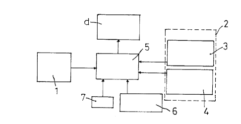
Figure 1 is a biock diagram of the system which is the subject of the invention.
Figure 2 is a l~u~tf~ellldliull in CûOI iilldl~s of the plot of a curve of a route to
be covered by tha vehicle.
Figure 3 is a Cul I l,Jdl ..t;ve rtfprt,~f lldliul ~ between the curve in figure 2 and the
actual curve obtained for a practicai implement- ation of the system.
Figure 4 is a comparative, tf,JI t~tfl lldliUI I between the curve in figure 2 and the
actual curve obtained through another practical i~ul~ entdllull of the system.
. 2~62830
In what follows, we describe an example of practical i, l Iyleme~ ation of
the present invention which is not limitative. We do not in any way discount
other forms of i" I,ule n ,u, l~d~iUn in which additional changes are introduced which
do not detract from the fullddlllellLdl principle; on the contrary, the present
invention also embraces all its variants.
In figure 1 we see:
- A memory module (1~ containing the ill~ulllldliun on the journey which the
vehicle can carry out. The joumey is divided into sections, each section being
identified by its pd,d",ulu,a (absolute position, radius (R) of section, length of
section).
- A set of sensors (2), for example two, which give three dynamic pdldlllULtU~
- Recorder sensitive to movement in a curve (3), for example a sensor to
measure the speed of turn of the vehicle in a bend (angular velocity of the
vehicle related to a perpendicular axis in the plane of movement). The speed
of turn of the vehicle in a bend can be obtained indirectly with the data comingfrom recorders based upon measuirement of lateral a~celerdtiol1s, lateral
dl:,lJldcelllullL, of the suspenslon elements, etc.
In physical and IlldL1l~llldLicdl terms, these variables are related to each
other, such that the pu~iLio~ 9 of the sensor or its nature can be optional,
provided that its a~r~ ~ 1 iS as indicated.
- A relative position recorder (4) to measure the variation in position of the
vehicle and its absolute velocity in the direction of movement. By way of
example, this sensor is fitted in one or more wheels of the vehicle, in such case
Involving an encoder which reports the angle through which the wheel has
turned in relation to the chassis of the vehicle. This measure-ment directly
~ 21~8~0
provides the variation in position of the vehicle. The absolute speed in the
direction of movement is obtained by passing the previous signal through a
frequency-voltage converter or also by means of a pulse counter for constant
intervals of time.
- A control unit CPU (5) with calculating capacity sufficient to evaluate the
control algorithms which the system needs and to supply the necessary data
(d) for example, position and velocity.
The basic system can be supl.le",e~ d and improved by two other
elements whose i, I-,ur ,uul dtiU n iS optional. One could add one or the other, both
or neither, depending upon the p 3~ " "''i for their use. Although not essentialfor the operation of the system, their use improves the robustness and ease of
use of the ultimate system. They are:
- Beacon recording equipment (6). This equipment records a series of
beacons placed along the route to be followed at points whose precise absolute
position is known. When the equipment detects a beacon, it notifies the CPU
(5) of the system directly and this consults its memory (1 ) to find the
cu,,~,uùnd-ing absolute posltion. The beacons used can be active (with
electrical col"leulion to an external or internal power supply source) and/or
passive (without electrical col " le~,tion to any power supply source).
- GPS (~qlobal pusilior,i"g system) (7). Global pu~;liol ,i"g systems are
equipment able to detect the absolute position of a receiver located at any polnt
on the earth. They utilise Illrulllldlioll obtained from satellites which circle the
earth in non-geo:,ldliolldl~ orbits. When the vehicle is stationary, the
i"f~ ", IdliUI I obtained from a GPS receiver allows an initial value to be obtained.
~62~30
In what follows we describe an example of practical i"lple~ "L-ation in
operation.
The vehicle commences to travel from an initial absolute position which
has been provided by automatic means (end of track, beacon, GPS, for
example) or by manual means (keyboard). Afterwards the control unit (5) uses
the illrulllldlion obtained from the relative position sensor (4) to update the
absolute position of the vehicle. Measurements like this sensor (4) can be
affected by various sources of error, such as: wear of the measurement wheel,
variations in diameter of the wheel, variations in the course followed by the
wheel, skidding during the phases of traction and braking of the vehicle, etc.
This means that measurements of absolute position obtained with the positlon
sensor (4) may not be entirely accurate. In order to improve accuracy, the
system il,Co,,uu~ u~, algorithms intended to correct the position of the vehiclecalculated with the i"ru,ll -:1 from the position measuring unit. These
correction algorithms are based upon the idel lLiriudLiul ,/pdl d~ L~I ~ of the actual
curves via analysis of the dynamic operating data obtained from the signals
received from sensors (3, 4) ar!d by comparing them with the L;,eol~tical data
for the ~ournay incorpor~ted b~rul~hdlld in the memory module (1).
This analysis consists of adjusting the profile in cuordi, IcL~ of the signal
received via sensors ~3 and 4) for an actual curve with the Lheo,~i~icdl profile of
the same curve which has been recorded in the memory (1). This adjustment
can be based upon achieving the mlnimum error between the two curves, the
theoret-ical one and the exlJeli",t:"Ldl one, according to the cool.lilldL~s.
Below we set out, by way of example, two methods of adjustment which
can be used. One is based upon adjustment by centre of gravity and the other
is based upon adjustment of the transition curve:
~. ~
- c~oq
216~o~0
- Method 1: adjustment of the centre of gravity (figures 2 and 3).
Along the routa there are a number of curves which, due to their
ulldld~ , basically because they are greater than a pre-fixed radius
threshold, have been taken as correction curves. We know their radius of
curvature (R), the length of the transition curves on entry (Lti) and on exit (Ltf)
and the length of the curve (Lcu), as can be seen in figure 2 (theoretical curve(ct)) as such, in which the ordinates are the inverse radius (I/R) and the
abscissas are their lengths indicating the absolute position (Pa).
With the data for the curve referred to previousiy, one can obtain the
centre of gravity (cdg) of the figura compared with an axis, for example, the
ordinate axis.
The vehicle continually records the signals obtained from the curve
detection sensor (3), measuring the angular velocity in the bend (fidot) and from
the position recorder (4) which supplies the movement velocity (vel) at constantintervals of di:~jJIdC~ (deltas). When tha vehicle is d,UI~l uaL.I ,i"g a
correction curve, with the data obtained from the sensors/recorders (3), (4)
operates giving rise to the figures i~p,~ ,lti"g the actual curve (cr~ with the
actual figures of radius of curvature and position. This operation is carried out
for all the samples found in the journey where it is assumed that there is the
curve of correction with a margin of di:,l,lace,l,t",l in front of and behind the
curve, i.e. the sampling of data co"""tli,.,es a little before the curve and
finishes a little after it (zone m). In figure 3 one can see the culll~d~ on
between the profile of the actual measurement (cr) and the Lheult:liudl data (ct)
of a curve In which the absolute position of the vehicle is in advance of the
U,eor~tical one.
After this, and after the entire correction curve has been passed through,
the centre of gravitv (cdgr) is calculated for the "Idll~er"~llical real curve
~1628~0
compared with the beginning, by means of a conventional mathematical
function.
This real value for the centre of gravity (cdgr) is compared with the
Ll ,eo, t:Licdl value (cdgt) which is stored in the memory. The difference between
the real value and the theoretical one pro-vides the correction (corr) between
the real position of the vehicle and the theoretical one.
corr = cdgr - cdgt
Before the absolute position data for the vehicle is updated with the new
position, a security test is carried out: the absolute value of the correction
(corr) must be below a threshold correction value (corr.um.). Should this not
be the case, tha correction (corr) is made equal to the value of the threshold
correction, with the sign of corr.
.
Once this check has been completed, the absolute position value (pos-
abs) is renewed in the following manner:
pos-abs = pos.abs-conr
The absolute position value will continue to be renewed using this new
value.
Method 2: adJustment of the transition curve.
This variant is based upon adjustment of the transition curve, both on
entry and on exit. Let us assume the circumstances in figure 4 in which the
vehicle will be ahead of the theoreticai route.
216283~
Now the correction algorithm will attempt to calculate the value of corr
corr= cdgr-cdgt
using as basis an adjustment depending upon the minimum error between the
actual curve and an incline parallel to that of the theoretical curve. The method
is exactly the same as tha previous orie, except that in that part of the
calculation of cdg-cdgr it is the distance which exists between the reference for
the measurements and the positlon in the abscissas of the centre of gravity of
the incline parallel (rp) to the theoretical incline ~rt) which provides the minimum
error adjustment with the actual curve (cr).
:
If the system is equipped with beacon r~coyl,ilioll facllities (6) the
following process will be carried out in parallel to the previous one.
1. The fact that beacon is being passed is r-coy"bed and its reference is
deterrnined.
2. With the beacon reference the data base for beacons in the memory (1) Is
consulted and the absolute position ~ o.~ d with the beacon in question is
obtained (pos.bal).
3. From this moment, the figure for the absolute position of the vehicle will bethe absolute position vaiue ~Cso~ pd with the beacon.
pos.abs= pos.bal
if in its turn the system has a GPS p~, one can either carry out a
process analogous to the previous one, or a security process for the benefit of
the updated i"fur,l ,dLion. The steps to be taken are as follows:
21~28~0
1. When the vehicle is stationary the ill~UUll.~'iJU received by the GPS
(longitude and latitude of the position of the vehicle) is processed during a
certain lapse of time and a measurement is calculated of the coùldilldL~s of
longitude and latitude.
2. With the coonii, IcL~ already measured, the data base of the memory of the
system is consulted and with these Gooldi, Idt~ds there is dssooidLt:d a value for
the absolute position of the vehicle (pos.gps).
3. The correction (corr) is calculated as the difference between the actual
position value (pos.abs) and the position obtained through the GPS (pos.gps).
corr = (pos.abs-pos.gps).
4. If the correction value is below a threshold value for the GPS cu~ uLiu~ ~s
(corr-um.gps) the data for the actual position (pos.abs) is to be taken as valid.
This threshold value is strictly llnked with the accuracy of the GPS. Otherwise,the updated value for the position (pos.abs) is replaced by the GSP valus
(pos.9ps~.