Language selection

Search

Patent 2163343 Summary

Third-party information liability

Some of the information on this Web page has been provided by external sources. The Government of Canada is not responsible for the accuracy, reliability or currency of the information supplied by external sources. Users wishing to rely upon this information should consult directly with the source of the information. Content provided by external sources is not subject to official languages, privacy and accessibility requirements.

Claims and Abstract availability

Any discrepancies in the text and image of the Claims and Abstract are due to differing posting times. Text of the Claims and Abstract are posted:

  • At the time the application is open to public inspection;
  • At the time of issue of the patent (grant).
(12) Patent Application: (11) CA 2163343
(54) English Title: METHOD AND APPARATUS FOR DETERMINING THE LOCATION OF A WORK IMPLEMENT
(54) French Title: PROCEDE ET APPAREIL DE DETERMINATION DE LA POSITION D'UN OUTIL DE TRAVAIL
Status: Dead
Bibliographic Data
(51) International Patent Classification (IPC):
  • E21B 21/06 (2006.01)
  • E02F 3/43 (2006.01)
  • E02F 3/42 (2006.01)
(72) Inventors :
  • GUDAT, ADAM J. (United States of America)
  • HENDERSON, DANIEL E. (United States of America)
  • SAHM, WILLIAM C. (United States of America)
(73) Owners :
  • CATERPILLAR INC. (United States of America)
(71) Applicants :
(74) Agent: KIRBY EADES GALE BAKER
(74) Associate agent:
(45) Issued:
(86) PCT Filing Date: 1995-04-27
(87) Open to Public Inspection: 1995-11-16
Availability of licence: N/A
(25) Language of filing: English

Patent Cooperation Treaty (PCT): Yes
(86) PCT Filing Number: PCT/US1995/005608
(87) International Publication Number: WO1995/030817
(85) National Entry: 1995-11-20

(30) Application Priority Data:
Application No. Country/Territory Date
240,348 United States of America 1994-05-10

Abstracts

English Abstract


An apparatus (702, 704, 706, 708, 802, 804, 806, 904, 906, 908, 910, 912) for determining the location of a work implement (102)
at a work site is provided. The appartus (702, 704, 706, 708, 802, 804, 806, 904, 906, 908, 910, 912) includes an undercarriage (116), a
car body (106) rotatably connected to the undercarriage (116), a boom (104) connected to the car body (106), a stick (110) connected to
the boom (104), a work implement (108) connected to the stick (110), and a positioning system (802, 804, 806) including a receiver (202)
connected to the stick (110) and a processor (704, 810, 818, 824) for determining the location of the receiver (202) in three dimensional
space at a plurality of points as the car body (106) is rotated and for determining the location and orientation of the work implement (108).


French Abstract

L'invention concerne un équipement (702, 704, 706, 708, 802, 804, 806, 904, 906, 908, 910, 912) destiné à déterminer la position d'un outil de travail (102) sur un chantier. Ledit équipement (702, 704, 706, 708, 802, 804, 806, 904, 906, 908, 910, 912) comporte un train chenillé (116), une caisse de véhicule (106) reliée rotative au train chenillé (116), une flèche (104) reliée à la caisse de véhicule (106), un bras (110) relié à la flèche (104), un outil de travail (108) relié au bras (110), ainsi qu'un système de détermination de position (802, 804, 806) comportant un récepteur (202) relié au bras (110) ainsi qu'un processeur (704, 810, 818, 824) destiné à déterminer la position du récepteur (202) dans un espace tridimensionnel au niveau d'une pluralité de points à mesure que la caisse de véhicule (106) tourne, et à déterminer la position ainsi que l'orientation de l'outil de travail (108).

Claims

Note: Claims are shown in the official language in which they were submitted.


-39-

Claims

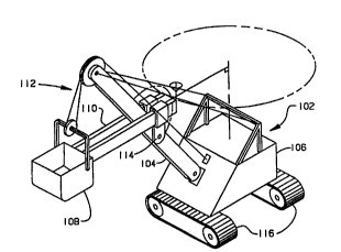
1. An apparatus (702, 704, 706, 708, 802, 804,
806, 904, 906, 908, 910, 912) for determining the location
of a digging implement (102) at a work site,
comprising:
an undercarriage (116);
a car body (106) rotatably connected to said
undercarriage (116);
a boom (104) connected to said car body
(106);
a stick (110) connected to said boom (104);
a work implement (108) connected to said
stick (110);
means (708, 830, 914) for rotating said car
body (106); and
a positioning system including a receiver
(202) connected to said stick (110) and a processing
means (704, 810, 818, 824) for determining the location
of said receiver (202) in three dimensional space at a
plurality of points as said car body (106) is rotated
and for determining the location and orientation of
said work implement (108) in response to the location
of said plurality of points.

2. An apparatus (702,704,706,708,802,804,
806,904,906,908,910,912), as set forth in claim 1,
wherein said processing means (704,810,818,824)
includes means (704,824) for determining the center
and radius of rotation of said receiver (202) as said
car body (106) rotates and the height of the plane of
rotation of said receiver (202) above the ground.

3. An apparatus (702,704,706,708,802,804,
806, 904, 906, 908, 910, 912), as set forth in claim 1,

- 40 -

wherein said stick (110) is pivotally and slidably
connected to said boom (104) .

4. An apparatus (702,704,706,708,802,804,
806,904,906,908,910,912), as set forth in claim 1,
including a storage device (706,824) in which a site
survey of the work site is stored; and
display means (708,814,830) for indicating
the location of said work implement (108) in the work
site.

5. An apparatus (702,704,706,708,802,804,
806,904,906,908,910,912), as set forth in claim 4,
wherein said display means (708,814,830) includes
means (708,814,830) for displaying ore locations and
overburden locations at the work site.

6. An apparatus (702,704,706,708,802,804,
806,904,906,908,910,912), as set forth in claim 4,
wherein said display means (708,814,830) includes
means (708,814,830) for displaying areas that remain
to be excavated and areas that have been excavated.

7. An apparatus (702,704,706,708,802,804,
806,904,906,908,910,912), as set forth in claim 4,
wherein said display means (708,814,830) includes
means (708,814,830) for indicating bench slope and
elevation.

8. An apparatus (702,704,706,708,802,804,
806,904,906,908,910,912), as set forth in claim 1,
including means ( 824) for determining when said work
implement (108) is being loaded.

-41-

9. An apparatus (702,704,706,708,802,804,
806,904,906,908,910,912), as set forth in claim 1,
wherein said receiver (202) is located substantially
on a centerline extending through said stick (110) in
a plane substantially perpendicular to the plane of
rotation of said car body (106).

10. An apparatus (702,704,706,708,802,804,
806,904,906,908,910,912), as set forth in claim 1,
where wherein said receiver (202) is substantially
displaced laterally from a centerline extending
through said stick (110) in a plane being
substantially perpendicular to the plane of rotation
of said car body (106).

11. An apparatus (702,704,706,708,802,804,
806,904,906,908,910,912) for determining the location
of a digging implement (108) at a work site,
comprising:
an undercarriage (116);
a car body (106) rotatably connected to said
undercarriage (116);
a boom (104) connected to said car body
(106);
a stick (110) connected to said boom ( 104);
a work implement (108) connected to said
stick (110);
means (708,830,914) for rotating said car
body (106);
a positioning system including a receiver
(202) connected to said stick (110);
an initialization means (802,804,806) for
determining the location and orientation of said car
body (106) when the undercarriage (116) has been
moved, said initialization means (802,804,806)

- 42 -

including a processing means (704,810,818,824) for
determining the location of said receiver (202) in
three dimensional space at a plurality of points as
said car body (106) is rotated and determining the
location and orientation of said work implement (108)
in response to the location of said plurality of
points; and
means (804,806) for tracking the location of
said work implement (108) throughout a work cycle in
response to the location of said receiver (202).

12. An apparatus (702,704,706,708,802,804,
806,904,906,908,910,912), as set forth in claim 11,
including means (804,806) for tracking the location of
the digging implement (108) as the undercarriage (116)
is moved.

13. An apparatus (702,704,706,708,802,804,
806,904,906,908,910,912), as set forth in claim 11,
wherein said stick (110) is rotatably and slidably
connected to said boom (104).

14. An apparatus ( 702,704,706,708,802,804,
806,904,906,908,910,912), as set forth in claim 11,
wherein said stick (110) is at a known point of
extension during initialization.

15. An apparatus (702,704,706,708,802,804,
806,904,906,908,910,912) for determining the location
of a digging implement (108) at a work site,
comprising:
an undercarriage ( 116);
a car body (106) rotatably connected to said
undercarriage (116);
a boom (104) connected to said car body (106);

- 43 -

a stick (110) connected to said boom (104);
a work implement (108) connected to said
stick (110);
means (708,830,914) for rotating said car
body (106);
means (708,830,914) for applying force to
said work implement (102);
means (824) for sensing power being
delivered to said work implement (102) and
responsively producing a digging signal;
a positioning system (802,804,806) including
a receiver (202) connected to said stick (110) and a
processing means (704,810,818,824) for determining the
location of said receiver (202) in three dimensional
space at a plurality of points;
means (804,806) for determining the location
of said work implement (108) in response to the
location of said plurality of points; and
means (706,826,908,910) for determining the
location of material being excavated from the work
site in response to said digging signal and the
location of said work implement (108).

16. An apparatus (702,704,706,708,802,804,
806,904,906,908,910,912), as set forth in claim 15,
including a storage device (706,824) in which a site
survey of the work site is stored; and
display means (708,814,830) for indicating
the location of said work implement (108) in the work
site.

17. An apparatus (702,704,706,708,802,804,
806,904,906,908,910,912), as set forth in claim 16,
wherein said display means (708,814,830) includes

- 44 -

means (708,814,830) for displaying ore locations and
overburden locations at the work site.

18. An apparatus (702,704,706,708,802,804,
806,904,906,908,910,912), as set forth in claim 16,
wherein said display means (708,814,830) includes
means (708,814,830) for displaying areas that remain
to be excavated and areas that have been excavated.

19. An apparatus (702,704,706,708,802,804,
806,904,906,908,910,912), as set forth in claim 16,
wherein said display means (708,814,830) includes
means (708,814,830) for indicating bench slope and
elevation.

20. An apparatus (702,704,706,708,802,804,
806,904,906,908,910,912), as set forth in claim 15,
including means ( 824) for determining when said work
implement (108) is being loaded.

21. A method (602,604,606,608,610,612,614)
for determining the location of a mining shovel (102)
at a work site, the mining shovel (102) including an
undercarriage (116), a car body (106) rotatably
connected to the undercarriage (116), a boom (104)
connected to the car body (106), a stick (110)
connected to the boom (104), and a work implement
(108) connected to the stick (110), comprising the
steps of:
rotating the car body (106);
receiving signals from an external reference
source (802);
determining the position of a point on the
stick (110) in response to the received signals;


-45-

determining the location of the point on the
stick (110) in three dimensional space at a plurality
of points as said car body (106) is rotated; and
determining the location and orientation of
the work implement (108) in response to the location
of the plurality of points.

22. A method (602,604,606,608,610,612,614),
as set forth in claim 21, including the steps of
determining the center and radius of rotation of said
receiver (202) as said car body (106) rotates and the
height of the plane of rotation of said receiver (202)
above the ground.

23. A method (602,604,606,608,610,612,614),
as set forth in claim 21, including the step of
displaying the location of the work implement (108) in
the work site.

24. A method (602,604,606,608,610,612,614),
as set forth in claim 23, including the step of
displaying ore locations and overburden locations at
the work site.

25. A method (602,604,606,608,610,612,614),
as set forth in claim 23, including the step of
displaying areas that remain to be excavated and areas
that have been excavated.

26. A method (602,604,606,608,610,612,614),
as set forth in claim 21, including the step of
determining when the work implement (108) is being
loaded.

-46-

27. A method (602,604,606,608,610,612,614)
for determining the location of a mining shovel (102)
at a work site, the mining shovel (102) including an
undercarriage (116), a car body (106) rotatably
connected to the undercarriage (116), a boom (104)
connected to the car body (106), a stick (110)
connected to the boom (104), and a work implement
(108) connected to the stick (110), comprising the
steps of:
rotating the car body (106);
receiving signals from an external reference
source (802);
determining the position of a point on the
stick (110) in response to the received signals;
initializing the determining the location
and orientation of the car body (106) after the
undercarriage (116) has been moved, said initializing
step including the steps of determining the location
of said point on the stick (110) in three dimensional
space at a plurality of points as said car body (106)
is rotated and determining the location and
orientation of the work implement (108) in response to
the location of the plurality of points; and
tracking the location of the work implement
(108) throughout a work cycle in response to the
location of the point on the stick (110).

28. A method (602,604,606,608,610,612,614),
as set forth in claim 27, including the step of
tracking the location of the digging implement (102)
as the undercarriage (116) is moved.

29. A method (602,604,606,608,610,612,614)
for determining the location of a mining shovel (102)
at a work site, the mining shovel (102) including an


- 47 -

undercarriage (116), a car body (106) rotatably
connected to the undercarriage (116), a boom (104)
connected to the car body (106), a stick (110)
connected to the boom (104), and a work implement
(108) connected to the stick (110), comprising the
steps of:
rotating the car body (106);
receiving signals from an external reference
source (802);
determining the position of a point on the
stick (110) in response to the received signals;
determining the location of the point on the
stick (110) in three dimensional space at a plurality
of points as said car body (106) is rotated; and
determining the location of the work
implement (108) in response to the location of the
plurality of points.
applying force to the work implement (108);
sensing the amount of power being delivered
to the work implement (108) and responsively producing
a digging signal; and
determining the location of material being
excavated from the work site in response to the
digging signal and the location of the work implement
(108).

30. A method (602,604,606,608,610,612,614),
as set forth in claim 29, including the step of
displaying the location of the work implement (108) in
the work site.

31. A method (602,604,606,608,610,612,614),
as set forth in claim 30, including the step of
displaying ore locations and overburden locations at
the work site.


-48-

32. A method (602,604,606,608,610,612,614),
as set forth in claim 30, including the step of
displaying areas that remain to be excavated and areas
that have been excavated.

33. A method (602,604,606,608,610,612,614),
as set forth in claim 30, including the step of
indicating bench slope and elevation.

34. A method (602,604,606,608,610,612,614),
as set forth in claim 29, the step of determining when
said work implement (108) is being loaded.

Description

Note: Descriptions are shown in the official language in which they were submitted.


~ WO95/30817 PCT~$95/05608
-- 2 1 63343

Descri~tion

Method and Apparatus for Determinina the Location
of a Work Implement

Technical Field
The invention relates generally to control
of work machines, and more particularly, to a method
and apparatus for determining the location and
orientation of a work implement in response to an
external reference.

Backqround Art
Work machines such as mining shovels and the
like are used for excavation work. These excavating
machines have work implements which consist of a boom,
a stick and a bucket. The stick and bucket are
controllably actuated by a set of cables and gear
drives. In the drawing shown in Fig. 1, a mining
shovel 102 is shown in which the boom 104 r~m~l n.~ in a
substantially fixed position with respect to the car
body 106, the bucket 108 is fixed to the stick 110,
and the stick llo is movable with respect to the boom
104 in response to hoist cables 112 and a gear drive
included in a yoke 114. An operator typically
manipulates the work implement to perform a sequence
of distinct functions which constitute a complete
excavation work cycle.
Prior art monitoring and control systems for
linkage type machines require multiple sensors to
determine the orientation and configuration of the
implement linkage or bucket. Linkage sensors such as
yo-yo devices and rotary sensors mounted on linkage
members moving relative to each other, in general,
have not proved to have long life. Also, if not only

WO95/30817 2 1 6 3 3 4 3 PCT/US95/05608 ~

--2 --

linkage orientation and configuration with respect to
the work machine is required but also position and
orientation of the work machine itself within the work
site, then separate sensors and systems are required
to provide the additional information.
For purposes of understanding the invention,
it is important to understand the following typical
characteristics of large mining shovels 102: a) The
end of the stick 110 furthest away from the bucket 108
does not pass through the boom 104; b) By moving the
stick 110 in or out fully, it is easy to position the
linkage so there is a known distance between the end
of the stick 110 and the center of rotation of the
stick yoke 114; and c) The shovel undercarriage 116
will not move when the operator is digging since the
same power supply cannot be used for travel and
digging simultaneously.
In mining operations, the current practice
of delineating ore from waste material or geographic
boundaries such as between adjacent properties is by
use of flags, stakes, or paint stripes on the material
to provide a visual reference to the operator. This
practice is less than ideal because flags, stakes, and
paint stripes can all be moved or destroyed during
normal mining operations plus they may be difficult to
see at night.
Ramifications of an operator not following
the flagged or staked setup plan can include sending
waste material instead of ore to processing, sending
ore to be disposed instead of waste material, and/or
incorrectly identifying the property from which a load
of ore was obtained.

~ WO95/30817 2 1 6 3 3 4 3 PCT~S95/05608

--3--

The present invention is directed to
overcoming one or more of the problems set forth
above.

Disclosure of the Invention
In one aspect of the invention, an apparatus
for determining the location of a work implement at a
work site is provided. The apparatus includes an
undercarriage, a car body rotatably connected to the
undercarriage, a boom connected to the car body, a
stick connected to the boom, a work implement
connected to the stick, and a positioning system
including a receiver connected to the stick and a
processor for determining the location of the receiver
in three ~lmen.qional space at a plurality of points as
~he car body is rotated and for determining the`
location and orientation of the work implement.
In a second aspect of the invention, a
method is provided for determining the location of a
mining shovel at a work site, the mining shovel
including an undercarriage, a car body rotatably
connected to the undercarriage, a boom connected to
the car body, a stick connected to the boom, and a
work implement connected to the stick. The method
includes the steps of rotating the car body, receiving
signals from an external reference source, determining
the position of a point on the stick in response to
the received signals, determining the location of the
point on the stick in three dimensional space at a
plurality of points as said car body is rotated, and
determining the location and orientation of the work
lmplement in response to the location of the plurality
of points.

WO95/30817 2 1 6 3 3 4 3 PCT~S95/05608 ~


The invention also includes other features
and advantages that will become apparent from a more
detailed study of the drawings and specification.

Brief Descri~tion of the Drawinqs
For a better understanding of the invention,
reference may be made to the accompanying drawings, in
which:
Fig. 1 is a diagrammatic illustration of a
cable mining shovel;
Fig. 2 is a schematic illustration of a
mining shovel operating in a work site;
Fig. 3 is a schematic illustration of a
mining shovel operating in a work site;
Fig. 4 is a schematic illustration of a
mining shovel operating on a work bench;
Fig. 5 is a schematic illustration of a
mining shovel operating in a work sitei
Fig. 6 is a block diagram describing the
interrelated system;
Fig. 7 is a block diagram describing the
interrelated system;
Fig. 8 is a block diagram describing the
interrelated system;
Fig. 9 is a block diagram of a machine
control;
Fig. 10 illustrates the geometry on which
portions of the system is based;
Figs. lla and llb illustrates the stick and
bucket in various positions with the receiver at
different locations on the stick;
Figs. 12a through 12i illustrate a flow
chart of an algorithm used in an embodiment of the
invention;
Fig. 13 illustrates the bench screen;

~ WO95/30817 2 1 6 3 3 4 3 PCT~S95/05608

--5--

Fig. 14 illustrates the ore screen;
Figs. 15a-c illustrate a flow chart of an
algorithm used in an embodiment of the invention; and
Figs. 16a and 16b illustrate a flow chart of
an algorithm used in an embodiment of the invention.

Best Mode for Carryinq Out the Invention
A mining shovel 102 is shown schematically
in Fig. 2 with a receiver 202 for a three ~;m~nqional
positioning system connected to the stick 110. In the
mining shovel of Fig. 1, the stick 110 is shown to
include box frames extending through the yoke 114 on
both sides of the boom 104. In this embodiment, the
receiver 202 is laterally displaced from a centerline
of the stick extending through said stick in a plane
that is substantially perpendicular to the plane of
rotation of the car body 106. In an alternative
embodiment, the stick 110 extends through the center
of the boom 104 and the receiver 202 is located on or
near the centerline of the stick 110.
The receiver 202 is advantageously connected
to the stick 110 such that the antenna orientation
does not change as the stick pivots with respect to
the boom. Without such compensation for changes in
orientation of the stick, the field of view of the
receiver 202 would change as the stick 110 pivots
about the boom 104 so that at some stick positions,
the receiver 202 would be unable to receive signals
from satellites in some portions of the sky.
In the preferred embodiment, the receiver
mounting is a pendulum type mounting including a pivot
with the receiver 202 being elevationally above the
pivot and a heavy weight (not shown) located
elevationally below the pivot. The weight and pivot
maintain the receiver 202 in substantially the same

WO95/30817 2 1 6 3 3 4 3 PCT~S95/05608 ~

--6--

orientatlon even though the stick to which it is
mounted pivots about the boom 104. A small portion of
the sky is still obscured if the car body 106 is
canted from the horizontal in the transverse
direction. However, in most operations this effect is
insignificant. To correct any error caused by this
effect, a more complex arrangement is included, such
as a bracket extending from the stick with a ball-
socket arrangement having the receiver 202 connected
to the ball above the socket and the heavy weight
connected to the ball below the socket. In this way,
the weight prevents the orientation of the receiver
202 from being changed along any axis when the machine
is within most normal ranges of operation. Other,
more complex arrangements to maintain the orientation
of the receiver 202 are also suitable for use in
connection with the invention without deviating from
its scope.
Fig. 2 diagrammatically illustrates
operation of the mining shovel 102 at a work site.
The target area 204 represents the material to be
excavated by the mining shovel 102 and may be ore,
overburden, or a combination of ore and overburden.
In typical operation, the machine operator manipulates
2S the controls for the undercarriage 116 to position the
mining shovel 102 near the target area 204. Once in
position, the operator controls the swing, hoist, and
crowd controls to excavate material from the target
area 204 and load haulage trucks that remove the
material to a waste pile or an ore processing site.

~ W095/30817 2 1 6 3 3 4 3 PCT~S95/05608


As shown in Fig. 3, the swing controls cause
the car body 106 to rotate about an axis of rotation
such that the receiver 202 travels through a swing
arc. The hoist control causes the hoist cables 112 to
rotate the stick about the yoke pivot of rotation such
that the receiver traces a hoist arc. The crowd
control causes the stick extend and retract through
the yoke 114. Note that as the stick is extended or
retracted, the swing arc and the hoist arc move with
respect to the axis of rotation and also have
different radii.
Fig. 4 illustrates the slope of the work
surface, known in the art as a bench. Mine managers
develop plans for excavating ore and overburden that
include bench elevation and slope. In operation,
however, the actual elevation and slope of the bench
may differ from plan. This can result in excavation
of the wrong material or a lack of correct information
being provided to mine managers and planners. To
solve this problem in the prior art, surveys of the
bench are made and either the mining shovel or other
support machines, such as track-type tractors or wheel
loaders, are used to groom the bench to the proper
slope and elevation.
Fig. 5 shows the mining shovel 102
excavating material from the target area 204. In most
digging operations by mining shovels, the center of
lhe bucket travels substantially more in the vertical
direction with respect to the car body than in the
horizontal direction.
It should also be understood that mining
shovels exert substantially more energy when the
machine is excavating material than when the bucket
and linkage are not engaged with material. This
allows an on-board system to sense when the mining

WO95/30817 2 1 63343 PCT~S95/05608 ~
--8--

shovel is digging by sensing the power being expended
by the hoist and crowd devices.
Turning now to Figure 6, the method of the
present invention is shown schematically. Using a
known three-dimensional positioning system with an
external reference, for example (but not limited to)
3-D laser, GPS, GPS/laser combinations, radio
triangulation, microwave, or radar, receiver 202
position coordinates are determined in block 602 as
the machine operates within the work site. These
coordinates are instantaneously supplied as a series
of discrete points to a differencing algorithm at 604.
The differencing algorithm calculates the receiver
position and path in real time. Digitized models of
the actual and desired site geographies are loaded or
stored at block 606, an accessible digital storage and
retrieval facility, for example a local digital
computer. The differencing algorithm 604 retrieves,
manipulates and updates the site models from 606 and
generates at 608 a dynamic site database of the
difference between the actual site and the desired
site model, updating the actual site model in real-
time as new position information is received from
block 602. This dynamically updated site model is
then made available to the operator in display step
610, providing real time position and site geography/
topography updates in human readable form. Using the
information from the display the operator can
efficiently monitor and direct the manual control of
the machine at 612.
Additionally, or alternately, the dynamic
update information can be provided to an automatic
machine control system at 614. The controls can
provide an operator assist to m;n;m; ze machine work
and limit the manual controls if the operator's

~ WO95/30817 2 1 6 3 3 4 3 PCT~S95/05608

_9_

proposed action would, for example, overload the
machine. Alternately, the site update information
from the dynamic database can be used to provide fully
automatic machine/tool control.
Referring now to Figure 7, an apparatus
which can be used in connection with the receipt and
processing of GPS signals to carry out the present
invention is shown in block diagram form comprising a
GPS receiver apparatus 702 with a local reference
antenna and a satellite antenna; a digital processor
704 employing a differencing algorithm, and connected
to receive position signals from 702; a digital
storage and retrieval facility 706 accessed and
updated by processor 704, and an operator display
and/or automatic machine controls at 708 receiving
signals from processor 704.
GPS receiver system 702 includes a satellite
antenna receiving signals from global positioning
satellites, and a local reference antenna. The GPS
receiver system 702 uses position signals from the
satellite antenna and differential correction signals
from the local reference antenna to generate position
coordinate data in three-~lmen~ions to centimeter
accuracy for moving objects. Alternatively, raw data
from the reference antenna can be processed by the
system to determine the coordinate data.
This position information is supplied to
digital processor 704 on a real-time basis as the
coordinate sampling rate of the GPS receiver 702
permits. The digital storage facility 706 stores a
first site model of the desired excavation, for
example according to a mining engineer's plan, and a
- ~econd digitized site model of the actual site
geography, for example as initially surveyed. The
site model corresponding to the actual site geography

WO 95/30817 2 1 6 3 3 4 3 PCT~S9S/05608 ~

-10--

can be accessed and updated in real time by digital
processor 704 as it receives new position information
from GPS receiver 702.
Digital processor 704 further generates
signals representing the difference between the
continuously-updated actual site model and the mining
engineer's plan. These signals are provided to the
operator display and/or automatic machine controls at
708 to direct the operation of the machine over the
site to bring the updated actual site model into
conformity with the plan. The operator display 708,
for example, provides one or more visual
representations of the difference between the actual,
continuously-updated site model and the desired site
model or ore locations to guide the operator in
excavating the desired material and in directing
loaded trucks to deliver the loads to either an
overburden pile or to the ore processor.
Referring now to Figure 8, a more detailed
schematic of a system according to Figure 7 is shown
using kinematic GPS for position reference signals. A
base reference module 802 and a position module 804
together determine the three-~;m~n~ional coordinates
of the receiver 202 relative to the site, while an
update/control module 806 converts this position
information into real time representations of the
machine, bucket, and work site which can be used to
accurately monitor and control the machine.
Base reference module 802 includes a
stationary GPS receiver 808; a computer 810 receiving
input from receiver 808; reference receiver GPS
software 812, temporarily or permanently stored in the
computer 810; a standard computer monitor screen 814;
and a digital transceiver-type radio 816 connected to
3 5 the computer and capable of transmitting a digital

~ WO95/30817 2 1 6 3 3 4 3 PCT~S95/05608

--11--

data stream. In the illustrative embodiment base
reference receiver 808 is a high accuracy kinematic
GPS receiver; computer 810 for example is a 486DX
computer with a hard drive, 8 megabyte RAM, two serial
communication ports, a printer port, an external
monitor port, and an external keyboard port; monitor
screen 814 is a passive matrix color LCD or any other
suitable display type, such as color VGA; and radio
816 is a commercially available digital data
transceiver.
Position module 804 comprises a matching
kinematic GPS receiver 202, a matching computer 818
receiving input from receiver 202, kinematic GPS
software 820 stored permanently or temporarily in
computer 818, and a matching transceiver-type digital
radio 822 which receives signals from radio 816 in
base reference module 802. In the illustrative
embodiment position module 804 is located on the
mining shovel to move with it over the work site.
Machine and bucket update/control module
806, also carried on board the machine in the
illustrated embodiment, includes an additional
computer 824, receiving input from position module
804; one or more digitized site models 826 digitally
stored or loaded into the computer memory; a dynamic
database update module 828, also stored or loaded into
the memory of computer 824; and an operator interface
830 including a color display screen connected to the
computer 824. Instead of, or in addition to, operator
interface 830, an automatic machine controls can be
connected to the computer to receive signals which
operate the machine in an autonomous or semi-
autonomous manner.
To provide further information regarding
operation of the mining shovel 102 to the computer

WO95/30817 2 1 6 3 3 4 3 PCT~S9J/05~08 ~

-12-

824, a hoist power sensor 832 is included providing an
indication of the amount of power being exerted by the
electric motor(s) driving the hoist cables 112. A
crowd power sensor 834 is included to provide a signal
indicative of the amount of power exerted by the
electric motor(s) used to extend and retract the stick
110. A travel current sensor 836 is advantageously a
switch for indicating when the undercarriage 116 is
being moved by the electric travel motor (not shown).
A forward/reverse indicator 838 indicates the
direction of travel selected by the operator. A swing
current sensor 840 provides a signal to indicate when
the swing motor is causing the car body 106 to rotate.
A bucket dump sensor 842 is included to indicate when
the operator actuates a mechanism to cause the bucket
108 to discharge its load. A truck loaded indicator
844 is advantageously a push button switch located in
the operator compartment which the operator depresses
when a truck has been completely loaded. In the
preferred embodiment, this push button switch also
activates a horn to signal the truck operator that the
truck is fully loaded and should be driven to the dump
site. As is well-known in the art, lights are often
included on large mining trucks to indicate to the
shovel operator when the truck is fully loaded. The
load indicating lights operate in response to the
truck payload monitoring system.
Although update/control module 806 is here
shown mounted on the mobile machine, some or all
portions may be stationed remotely. For example,
computer 824, site model(s) 826, and dynamic database
828 could be connected by radio data link to position
module 804 and operator interface 830. Position and
site update information can then be broadcast to and

WO95/30~17 _l3_ PCT~S95/0560


from the machine for display or use by operators or
supervisors both on and off the machine.
Base reference station 802 is fixed at a
point of known three-dimensional coordinates relative
5 to the work site. Through receiver 808 base reference
station 802 receives position information from a GPS
satellite constellation, using the reference GPS
software 812 to derive an instantaneous error quantity
or correction factor in known manner. This correction
factor is broadcast from base station 802 to position
,station 804 on the mobile machine via radio link
816,822. Alternatively, raw position data can be
transmitted from base station 802 to position station
804 via radio link 816,822, and processed by computer
818.
Machine-mounted receiver 202 receives
position information from the satellite constellation,
while the kinematic GPS software 820 combines the
signal from receiver 202 and the correction factor
20 from base reference 802 to determine the position of
receiver 202 relative to base reference 802 and the
work site within a few centimeters. This position
information is three-dimensional (e.g., latitude,
longitude and elevation) and is available on a point-
25 by-point basis according to the sampling rate of the
GPS system.
Referring to update/control module 806, once
the digitized plans or models of the site have been
loaded into computer 824, dynamic database 828
30 generates signals representative of the difference
between actual and desired site geography to display
this difference graphically on operator interface 830.
For example, profile and/or plan views of the actual
and desired site models are combined on screen 830 and
35 the elevational difference between their surfaces and

WO95/30817 2 1 6 3 3 4 3 PCT~S95/05608 ~
-14-

the relative ore content of material in different
areas are indicated. Using the position information
received from position module 804, the database 828
also generates a graphic icon of the machine
5 superimposed on the actual site model on operator
interface 830 corresponding to the actual position and
direction of the machine on the site.
Because the sampling rate of the position
module 804 results in a time/distance delay between
position coordinate points as the machine operates,
the dynamic database 828 of the present invention uses
a differencing algorithm to determine and update in
real-time the path of the receiver 202.
With the knowledge of the bucket's exact
position relative to the site, a digitized view of the
site, and the machine's progress relative thereto, the
operator can maneuver the bucket to excavate material
without having to rely on physical markers placed over
the surface of the site. And, as the operator
operates the machine within the work site the dynamic
database 828 continues to read and manipulate incoming
position information from module 804 to dynamically
update both the machine's position relative to the
site and the position and orientation of the bucket.
The mining shovel 102 is e~uipped with a
positioning system capable of determining the position
of the machine and/or its bucket 108 with a high
degree of accuracy, in the preferred embodiment a
phase differential GPS receiver 202 located on the
machine at fixed, known coordinates relative to the
stick 110. Machine-mounted receiver 202 receives
position signals from a GPS constellation and an
error/correction signal from base reference 808 via
radio link 816,822 as described in Figure 8. Machine-
mounted receiver 202 uses both the satellite signals

~ WO95/30817 2 1 63343 PCT~S95/05608

-15-

and the error/correction signal from base reference
808 to accurately determine its position in three-
dimensional space. Alternatively, raw position data
can be transmitted from base reference 808, and
processed in known fashion by the machine-mounted
receiver system to achieve the same result.
Information on kinematic GPS and a system suitable for
use with the present invention can be found, for
example, in U.S. Patent No. 4,812,991 dated March 14,
1989 and U.S. Patent No. 4,963,889 dated October 16,
1990, both to Hatch. Using kinematic GPS or other
suitable three-dimensional position signals from an
external reference, the location of receiver 202 can
be accurately determined on a point-by-point basis
within a few centimeters as the mining shovel 102
operates within the work site. The present sampling
rate for coordinate points using the illustrative
positioning system is approximately one point per
second.
The coordinates of base receiver 808 can be
determined in any known fashion, such as GPS
positioning or conventional surveying. Steps are also
being taken in this and other countries to place GPS
references at fixed, nationally surveyed sites such as
airports. If the reference station is within range
(currently approximately 20 miles) of such a
nationally surveyed site and local GPS receiver, that
:Local receiver can be used as a base reference.
Optionally, a portable receiver such as 808, having a
tripod-mounted GPS receiver, and a rebroadcast
transmitter can be used. The portable receiver 808 is
surveyed in place at or near the work site.
In the preferred embodiment, the work site
nas previously been surveyed to provide a detailed
topographic design showing the mining engineer~s

WO95/30817 2 1 6 3 3 4 3 PCT~S95/05608
-16-

finished site plan overlaid on the original site
topography including ore location and overburden
location in both plan and profile view. The creation
of geographic or topographic designs of sites such as
landfills, mines, and construction sites with optical
surveying and other techniques is a well-known art;
reference points are plotted on a grid over the site,
and then connected or filled in to produce the site
contours on the design. The greater the number of
reference points taken, the greater the detail of the
map.
Systems and software are currently available
to produce digitized, three-dimensional maps of a
geographic site. For example, the mining engineer's
site plan can be converted into three-~lm~n~ional
digitized models of the original site geography or
topography. The site contours and ore locations can
be overlaid with a reference grid of uniform grid
elements in known fashion. The digitized site plans
can be superimposed, viewed in two or three dimensions
from various angles (e.g., profile and plan), and
color coded to designate areas in which the site needs
to be excavated, ore location of various quality, and
overburden location. Available software can also make
cost estimates and identify various site features and
obstacles above or below ground.
However the work site is surveyed, and
whether the machine operators and their supervisors
are working from a paper design or a digitized site
plan, the prior practice is to physically stake out
the various contours or reference points of the site
with marked instructions for the machine operators.
Using the stakes and markings for reference, the
operators must estimate by sight where and how much to
excavate. Periodically during this process the

~ WO95/30817 2 1 6 3 3 4 3 PCT~S9S/05608
-17-

operator's progress is manually checked to coordinate
the contouring operations in static, step-by-step
fashion until the final contour is achieved. This
manual periodic updating and checking is labor-
intensive, time consuming, and inherently providesless than ideal results.
Moreover, when it is desired to revise the
design or digitized site model as an indicator of
progress to date and work to go, the site must again
be statically surveyed and the design or digitized
site model m~nl~lly corrected off-site in a non-real
time manner.
To eliminate the drawbacks of prior art
static surveying and updating methods, the present
invention integrates accurate three-dimensional
positioning and digitized site mapping with a
dynamically updated database and operator display for
real-time monitoring and control of the site 12 and
machine 10.
Referring now to Figure 9, a system
according to the present invention is schematically
shown for closed-loop automatic control of one or more
machine or tool operating systems. While the
embodiment of Figure 9 is capable of use with or
without a supplemental operator display as described
above, for purposes of this illustration only
automatic machine controls are shown. A suitable
digital processing facility, for example a computer as
described in the foregoing embodiments, containing the
algorithms of the dynamic database of the invention is
shown at 904. The dynamic database 904 receives 3-D
instantaneous position information from GPS receiver
system 906. The desired digitized site model 908 is
loaded or stored in the database of computer 904 in
any suitable manner, for example on a suitable disk

WO95/30817 2 1 6 3 3 4 3 PCT~S95/05608 ~

-18-

memory. Automatic machine control module 912 contains
machine controls 914 connected to operate, for
example, steering, tool and drive systems 916,918,920
on the mining shovel 102. Automatic machine controls
914 are capable of receiving signals from the dynamic
database in computer 904 representing the difference
between the actual site model 910 and the desired site
model 908 to operate the steering, tool and drive
systems of the machine to bring the actual site model
into conformity with the desired site model. As the
automatic machine controls 914 operate the various
steering, tool and drive systems of the machine, the
alterations made to the site and the current position
and direction of the machine are received, read and
manipulated by the dynamic database at 904 to update
the actual site model. The actual site update
information is received by database 904, which
correspondingly updates the signals delivered to
machine controls 914 for operation of the steering,
tool and drive systems of the machine as it progresses
over the site to bring the actual site model into
conformity with the desired site model.
Turning now to the illustration of Fig. 10,
the calculation of the location and orientation of the
car body 106 and the location of the bucket 108 which
is performed by the computer 824 is described. As
described below, ~oll and pitch of an excavator refers
to the side-side and fore-aft slope. Since a shovel
rotates, roll and pitch continually varies from the
operator's perspective in many operating environments.
Therefore, the equation of the plane upon which the
car body 106 rotates is calculated, and from this
equation, the slope, or roll and pitch, can be
displayed using whatever frame of reference is
desired. The two most common frames of reference

~ WO95/30317 2 1 6 3 3 4 3 PCT~S95/05608

--19--

would be to display the surface using perpendicular
axes determined by N-S and E-W, or along and
transverse to the machines fore-aft axis.
The calculations listed below determine the
equation of a plane from the x, y, and z coordinates
of 3 points sampled by the receiver 202. For ease of
understanding, arbitrary values were selected to
provide sample calculations; however, none of the
values used should in any way limit the generality of
the invention and these formulae.

To calculate the Plane of Rotation Through 3 Sampled
Points:

15 ptl = (ptlx,ptly,ptlz) (1,1,3) PNT1
pt2 = (pt2x,pt2y,pt2z) (7,2,2) PNT2
pt3 = (pt3x,pt3y,pt3z) (2,5,1) PNT3
ptlx*A + ptly*B + ptlz*C + D = 0
Pt2x*A + pt2y*B + pt2z*c + D = 0
Pt3x*A + pt3y*B + pt3z*c + D = o

By solving the above formulae, the following solution
is obtained:

-.02439*pt_x-.13414*pt_y-.28049*pt_z + 1 = 0

For a simple example, assume an operator is
facing North (positive y direction in this example).
The side-side roll is calculated by picking any two x
values on a plane perpendicular to the direction and
calculating the z values.

WO95/30817 2 1 6 3 3 4 3 PCT~S95/05608 ~

-20-

For x = 0, y = 0, z = 3.56519
x = 7, y = 0, z = 2.9565
Side-Side roll = (2.9565-3.56519)/(7-0) = .08696
with West higher than East
= 4.96 degrees

Similarly, the fore-aft pitch can be calculated;
For x = 7, y = 0, z = 3.56519
x = 7, y = 5, z = 1.17402
Fore-aft pitch = ((1.17402-3.56519)/(5) = .47823
with South higher than North
= 25.56 degrees

In the preferred embodiment, the center of
rotation of the arc described by the rotation of the
antenna and 3 sampled points is determined by locating
the intersection of 3 planes. One plane is determined
by the rotation of the antenna. A second plane is
perpendicular to and extending through the midpoint of
a line connecting pt 1 and pt 2. A third plane is
perpendicular to and extending through the midpoint of
a line connecting pt 2 to pt 3. Sample calculations
to determine the center of rotation of the antenna
rotation are listed below.
Calculate the Plane Perpendicular to Line From ptl and
pt2 Through the Midpoint

ptl = (ptlx,ptly,ptlz) (1,1,3)
pt2 = (pt2x,pt2y,pt2z) (7,2,2)

midpt_1_2 = ( (ptlx+pt2x)/2, (ptly+pt2y)/2,
(ptlz+pt2z)/2)

midpt_1_2 = ( 4,1.5,2.5 )

~ WO95/308l7 2 1 6 3 3 4 3 PCT~S95/05608


dir_num_x = pt2x - ptlx = 6
dir_num_y = pt2y - ptly = 1
dir_num-z = pt2z - ptlz = -1

where dir_num_x, dir_num_y, and dir_num_z refer to the
direction number of x, y, and z, respectively.

0=dir_num_x*(X-midpt_1_2_x)+dir_num_y*(Y-
midpt_l_2_y)+dir_num_z*(Z-midpt-l-2-z)
where midpt_l_2_x, midpt_l_2_y, and midpt_l_2_z refer
to the x, y, and z coordinates, respectively, of the
midpoint of the line connecting ptl and pt2.

Solving for the equation of the plane provides:

0 = 6pt_x + pt_y - pt_z - 23

Similarly, calculate the Plane Perpendicular to Line
From pt2 and pt3 Through the Midpoint.

pt2 = (pt2x,pt2y,pt2z) (7,2,2)
pt3 = (pt3x,pt3y,pt3z) (2,5,1)

midpt_2_3 = ( (pt2x+pt3x)/2, (pt2y+pt3y)/2,
(pt2z+pt3z)/2)

midpt_2_3 = ( 4.5,3.5,1.5 )

dir_num_x = pt3x - pt2x = -5
dir_num_y = pt3y - pt2y = 3
dir_num-z = pt3z - pt2z = -1

0=dir_num_x*(X-midpt_2_3_x)+dir_num_y*(Y-
midpt_2_3_y)+dir_num_z*(Z-midpt_2_3_z)

WO95/30817 2 1 6 3 3 4 3 PCT~S95/05608 ~

-22-

0 = -5pt_x + 3pt_y - pt_z + 13.5

Calculate Point of Intersection Between Plane of
Rotation, Plane Perpendicular to Midpoint Ptl_2, and
Plane Perpendicular to Midpoint Pt2_3

-.02439*pt_x -.13414*pt_y-.28049*pt_z + 1 = 0
= Plane of Rotation

6pt_x + pt_y- pt_z - 23 - 0
= Plane Perp to Midpt Ptl_2

-5pt_x + 3pt_y- pt_z + 13.5 = 0
= Plane Perp to Midpt Pt2_3
23pt_y - llpt_z - 34 = 0
= Intersection of the 2 Planes through Midpoints

To calculate the point of the center of rotation of
the receiver:

-.02439*pt_x-.13414*pt_y -.28049*pt_z + 1 = 0
6pt_x+ pt_y - pt_z - 23 = 0

pt_y = -2.1876pt_z + 6.96909

pt_z_ant_rot_center = 2.05968
pt_y_ant_rot_center = (llpt_z + 34)/23 = 2.46333
pt_x_ant_rot_center = (-pt_y + pt_z + 23)/6 = 3.76606
Once the center of rotation is known, the
distance to any of the previously sampled 3 points is
the radius of the antenna rotation. For the shovel
system in which the antenna is mounted to the linkage,

~ w09s/30gl7 2 1 6 3 3 4 3 PCT~S95/05608


this radius will be a function of the height of
antenna rotation above the ground.

Calculate The Radius of the Arc of the antenna
rotation.

radius = ((pt_x_ant_rot_center-ptlx)A2+
(pt_y_ant_rot_center-ptly)A2+
(pt_z_ant_rot_center-ptlz)^2) A . 5
According to the above sample calculations,
radius = 3.26751

Once the height of antenna rotation above
the ground is determined from a look up table or
equation which contains basic linkage data (or a fixed
distance if the antenna is mounted on the carbody),
the intersection of the line of carbody rotation and
the ground can be calculated. This point is important
because the z coordinate indicates the elevation of
the ground directly beneath the machine which can be
compared to the desired bench height.

Calculate the Point of Intersection with the Ground.
From the machine geometry, a table or equation is
provided in the memory associated with the computer
824 for correlating the radius of antenna rotation to
the distance from the plane of antenna rotation to the
ground. Note by reference to Fig. 3 that when the
stick 110 is at a known point of extension or
retraction, the radius of antenna rotation corresponds
- to a unique height of the plane of rotation above the
ground, provided the bucket is not hoisted above a
point at which the stick is substantially horizontal

WO95/30817 2 1 6 3 3 4 3 PCT~S95/05608 ~
-24-

with respect to the plane of rotation. In the
preferred embodiment, the known point of extension or
retraction is the fully extended or fully retracted
position.
s


Assume now that the following values were included in
the radius versus height look-up table:

height = 5 for radius = 3.26751
The equation of a line perpendicular to the plane
through the center of antenna rotation as derived
above is:

-.02439*pt_x-.13414*pt_y-.28049*pt_z + 1 = 0

pt x ant rot center = 3 76606
pt_y_ant_rot_center = 2.46333
pt_z ant rot center = 2.05968_
pt_x_gnd_rot_center = 3.76606 - .02439t
pt_y_gnd_rot_center = 2.46333 - .13414t
pt_z_gnd_rot_center = 2.05968 - .28049t

height = 5 = ((-.02439t) 2 + (.13414t) 2 +
(.28049t) 2) .5
5 = .31187t ; t = 16.03231

pt_x_gnd_rot_center = 3.76606 - .02439t = 3.37503
pt_y_gnd_rot_center = 2.46333 - .13414t = .31276
pt_z_gnd_rot_center = 2.05968 - .28049t = 2.43722

Where pt_x_gnd_rot_center, pt_y_gnd_rot_center, and
pt_z_gnd_rot_center are the coordinates in x, y, and

~ WO95/30817 2 1 6 3 3 4 3 PCT~S95/05608

-25-

z, respectively, of the intersection of the axis of
rotation with the ground.

Now, enough information is known to display
the shovel location and linkage position relative to
t:he surroundings. With a known location and
orientation of the shovel, each point of the receiver
202 defines a unique location of the bucket 108. As
the shovel works and rotates, the angular rotation can
also be calculated and displayed.
At first, it would seem that since the line
of rotation is known and the coordinates of the GPS
antenna are continually being sampled, that the plan
view could be displayed simply by monitoring the X, y
coordinates of the antenna relative to the center of
rotation. However, since the present invention is a
general system in which the antenna does not have to
be mounted along the linkage axis, it is possible to
have identical x,y antenna coordinates for different
carbody rotations. This possible outcome is
illustrated in Figs. lla and llb.
Fig. lla illustrates the receiver 202
]ocated off the centerline of the stick. In this
embodiment, it can be seen that if the car body
rotates at the same time the stick is retracted, the
angular offset of the receiver from its original
location is substantially different from the angular
movement of the stick itself, represented by the angle
theta. Fig. llb, on the other hand, illustrates an
embodiment in which the receiver 202 is connected to
the stick along its centerline. In this case, the
angular offset of the receiver 202 from its original
location is also equal to theta.
To compensate for the case illustrated in
Fig. lla, a plane is calculated through each sampled

WO9S/30817 2 1 6 3 3 4 3 PCT~S95/05G08
-26-

point and 2 fixed points along the axis of rotation,
the center of rotation of the initial antenna arc and
the intersection of the line of rotation with the
ground. Sample angle calculations are shown below.


To calculate the rotation angle of the carbody from
ptl to pt2:

pt_x_ant_rot_center = 3.76606 PNT4
pt_y_ant_rot_center = 2.46333 PNT4
pt_z_ant_rot_center = 2.05968 PNT4
¦- These points
pt_x_gnd_rot_center = 3.37503 PNT5 ¦ are fixed for
pt_y_gnd_rot_center = .31276 PNT5 ¦ a given load-
pt_z_gnd_rot_center = 2.43722 PNT5 1 ing location.

ptlx = 1.0 PNTl
ptly = 1.0 PNTl
ptlz = 3.0 PNTl

3.76606A + 2.46333B + 2.05968C + D = 0
3.37503A + .31276B - 2.43722C + D = 0
A + B + 3C + D - 0
Solving provides:

-.72136x + 1.07387y - .45083z + 1 = 0
Al Bl Cl Dl
pt_x_ant_rot_center = 3.76606 PNT4
pt_y_ant_rot_center = 2.46333 PNT4
pt_z_ant_rot_center = 2.05968 PNT4
¦- These points
pt_x_gnd_rot_center = 3.37503 PNT5 ¦ are fixed for

~ WO95/30817 2 1 6 3 3 4 3 PCT~S95/05608

-27-

pt_y_gnd_rot_center = .31276 PNT5 ¦ a given load-
pt_z_gnd_rot_center = 2.43722 PNT5 1 ing location.

pt6x = 1.16048 PNT6
pt6y = .78234 PNT6
pt6z = 3.09014 PNT6

3.76606A + 2.46333B + 2.05968C + D = 0
3.37503A + .31276B - 2.43722C + D = 0
1.16048A + .78234B + 3.09014C + D = 0

-.5708x + .70838y - .28848z + 1 = 0
A2 B2 C2 D2
cos (theta) =

(AlA2 + BlB2 + ClC2 ) A 2) A , 5
((Al 2+B1 2+C1 2)) .5 * ((A2 2+C2 2)) .5

cos (theta) =
((-.72136*-.5708+1.07387*.70838-.45083*-.28848) 2) .5

((-.72136) 2+1.07387 2+(-.45083) 2) .5* ((-.5708) 2 +
.70838 2+(-.28848 2)) .5
cos(theta) = .99622

theta = 4.9862 degrees

Where theta = the angle between planes defined by
points 4, 5, 6 and points 1, 4, 5 plus Beta 1 minus
Beta 6.

A flow chart of an algorithm to be executed
by the computer 824 in one embodiment of the invention

WO95/30817 2 1 6 3 3 4 3 PCT~S95/05608 ~

-28-

is illustrated in Figs. 12a - 12i. The GPS reference
station 802, the mining shovel 102, and the on-board
electronics are powered up at block 1202. The shovel
geometry and site data are uploaded to the computer
824 form the data base 828 in blocks 1204 and 1206,
respectively. The variables and flags listed in block
1208 are initialized. The GPS position of the
receiver 202 is sampled and time stamped at block
1210. The signals from the hoist power sensor 832,
crowd power sensor 834, travel current sensor 836,
forward/reverse indicator 838, swing current sensor
840, bucket dumped sensor 842, and truck loaded
indicator 844 are sampled at blocks 1212-1224,
respectively.
If travel current is greater than zero at
block 1226 thus indicating that the undercarriage is
moving, then the static_setup and rotation_setup flags
are set equal to "false" and control passes to block
1262. Similarly if rotation_setup is true at block
1228 thus indicating that the rotation setup at that
location has been completed, control passes to block
1262. If static_setup is true at block 1230 thus
indicating that the static_setup has been completed,
then control passes to block 1238.
At block 1232, the operator is prompted via
the operator interface 830 to use the crowd control to
move the stick to either the full in or full out
position. Whether full in or full out is selected is
a simple matter of design choice for the system
designer. The operator then uses a keypad included in
the operator interface to indicate that the stick has
been moved to the requested position. When the
ready_for_static flag is therefore set equal to
"true", the receiver 202 location is sampled and
averaged for a predetermined length of time. The

~ WO95/30~17 2 1 6 3 3 4 3 PCT~S95/0~608

-29-

phrase "static setup complete" is then displayed on
the operator interface 830 and the static_setup flag
is set equal to "true" at block 1236.
At block 1238, the operator interface 830
displays the message "swing car body". The operator
:is instructed that the hoist, crowd, and travel
controls are not to be manipulated during swing. When
swing_current is sensed to exceed zero, receiver 202
locations derived by the kinematic GPS system are
stored at regular intervals until the operator
indicates via the keypad that rotation sampling is
complete at block 1242. The operator interface 830
then indicates the ~'rotation setup is complete" and
the rotation_setup flag is set equal to "true". The
shovel_position_count is incremented at block 1246.
The plane of rotation of the receiver 202 is
calculated in block 1248 as described above in
connection with Fig. 10. The computer 824 then
calculates at block 1250 a look-up table of the fore-
aft pitch and side-side roll of the car body for the
360 degrees of rotation. Alternatively, the North-
South inclination and East-West inclination of the car
body is displayed on the operator interface 830.
At blocks 1252 and 1254, the center of
rotation of the plane of receiver rotation and the
radius of the arc described by the receiver 202
movement are calculated as described above in
connection with Fig. 10. The equation of the line of
rotation perpendicular to the plane of the car body
106 is calculated at block 1256 and the distance from
the center of rotation of the receiver 202 from the
ground is calculated at block 1258. The coordinates
- of the intersection of the line of rotation with the
ground is determined at block 1260. At block 1262,
the location of the bucket 108 is determined in

WO95/30817 2 1 6 3 3 4 3 PCT~S95/O~Go8 ~
-30-

response to the location of the receiver 202 and the
above calculated values.
If travel current is greater than zero at
block 1264, then the current and last recelver
positions are used to calculate the location of the
mining shovel 102. In the preferred embodiment, it is
assumed that travel occurs only when front of the car
body 106 is facing in the direction of undercarriage
travel. This assumption allows ease of tracking of
the shovel during travel.
Alternatively, the position of the work
machine is only calculated, and the machine displayed
at the work site, in response to the sampled points
fitting the definition of a circle. This generally
will occur only when the carbody rotates and the
undercarriage is stationary.
At block 1266, the shovel and bucket
relative to the work site are displayed. As shown in
Figs. 13 and 14, a bench screen and an ore screen are
displayed on the operator interface 830. A production
screen is also available for display in text form
including the number of trucks loaded, the number of
bucket loads, the average time required to load a
truck, average bucket location during loading of a
truck, the grade of ore being excavated, payload
excavated and the like.
The bench screen shown in Fig. 13
illustrates a plan view of the mining shovel 102 in
the work site with various ranges of elevation with
respect to the plan bench elevation being designated
by a plurality of colors. A bar graph is also
illustrated in the upper left hand area of the
operator interface indicating the elevation with
respect to desired bench elevation of the point of
intersection of the axis of rotation with the ground.

WO95/303l7 31 PCT~595/~56~8


The lower portion of the operator interface 830 also
indicates the fore-aft pitch and the side-side roll of
~he car body. The left hand portion of the
illustration may be designed as either a touch screen
or a separate key pad for selecting the available
display screens.
The ore screen shown in Fig. 14 illustrates
both a plan and profile view of the mining shovel 102
in the work site with overburden and ore indicated by
various colors. Different grades of ore may also be
designated by different colors on the display. Areas
that have already been excavated are indicated by
still a different color. A bar graph is also
illustrated in the upper left hand area of the
operator interface indicating the elevation with
respect to desired bench elevation of the point of
intersection of the axis of rotation with the ground.
The lower portion of the operator interface 830 also
indicates the fore-aft pitch and the side-side roll of
the car body. The left hand portion of the
illustration may be designed as either a touch screen
or a separate key pad for selecting the available
display screens.
Returning now to the flow chart of Fig. 12,
block 1268 determines whether the sensed crowd or
hoist power is greater than respective setpoint values
to indicate that the bucket 108 has entered the
material and is excavating. If the shovel is not
digging, control passes to block 1272. If the shovel
is excavating material, the bucket_loading flag is set
to "true", the bucket_load_count is incremented, and
the bucket_dumped_command flag is set to "false". At
block 1272, the center of the bucket or cutting edge
is calculated and stored for each sample of receiver
location as long as the bucket_loading flag is "true".

WO95/30817 2 1 6 3 3 4 3 PCT~S95/05608 ~

-32-

If swing_current is greater than zero, then
the bucket_loading flag is set to "false" at block
1274 and the payload is determined at block 1275. As
is understood by those skilled in the art, payload is
determined at block 1275 in response to the hoist
power signal, shovel geometry, and stick/bucket
position obtained from the present invention. The
average center of bucket or cutting edge location for
the bucket loading cycle just completed is calculated
at block 1276. Using the shovel geometry imported in
block 1204, the area that has been excavated is
determined in response to the average center of bucket
or cutting edge location and the ~lmen~ions of the
bucket. If the swing_current is substantially zero,
control passes back to block 1210.
If truck_loaded_signal flag is "true", then
the average center of bucket or cutting edge location
for the just completed loading cycle is stored and the
display is updated at blocks 1278 and 1282.
Otherwise, control passes to block 1210. The data is
stored for a permanent record at block 1284. The
truck loaded signal flag is set to "false" and the
truck_load_count is incremented at block 1286.
Control then returns to block 1210.
Turning now to Figs. 15a-c and 16a-b, an
alternative method of indicating the location of
material having been excavated by the shovel is
illustrated in flow chart form and is advantageously
included in the calculations of block 1276. As
described above, the work site is displayed in grid
form. An accurate determination of the grid squares
through which the bucket 108 passes is necessary to
provide real time updates of the operator's work on
the dynamic site plan. The size of the grid elements
on the digitized site plan is fixed, and although the

~ WO95t30317 2 1 6 3 3 43 PCT~S95/05608
-33-

width of several grid elements can be matched evenly
to the width of the bucket, the blade will not always
completely cover a particular grid element. Even if
the bucket width is an exact multiple of grid element
width, it is rare that the machine would travel in a
direction aligned with the grid elements so as to
completely cover every element in its path.
To remedy this problem, in Figs. 15a-c a
~ubroutine determines the path of the operative
portion of the bucket 108 relative to the site plan
grid. At step 1502 in Fig. 15a, the module determines
whether the machine-mounted receiver position has
changed latitudinally or longitudinally (in the x or y
directions in an [x, y, z] coordinate system) relative
~o the site. If yes, the system at step 1504
determines whether this is the first system loop. If
~he present loop is not the first loop, the
machine/bucket path determined and displayed from the
previous loops is erased at step 1506 for updating in
the present loop. If the present loop is the first
loop, step 1506 is simply bypassed, as there is no
machine path history to erase.
At step 1508 the mining shovel 102 and
bucket 108 are initially drawn. If already drawn, the
rnining shovel 102 and bucket 108 are erased from the
previous position on the site model plan at step 1510.
At step 1512 the system determines whether the bucket
center's current position coordinates are outside the
grid element occupied in the last system loop.
If at step 1512 the position of the machine
has not changed, for example if the shovel is parked
or idling, the system proceeds to steps 1520-1528.
If at step 1512 the position of the machine
relative to the site plan grid has changed, the system
proceeds to step 1514 where it designates "effective"

WO95/30817 2 1 6 3 3 4 3 PCT~S95/05608 ~


bucket ends inboard from the actual bucket ends. In
the illustrated embodiment the effective bucket ends
are recognized by the differencing algorithm as
inboard from the actual ends a distance approximately
one half the width of a grid element. For example, if
the actual bucket 108 is 10.0 feet long, corresponding
to five 2.0 ft. x 2.0 ft grid elements, the effective
locations of the bucket ends are calculated at step
1514 one foot inboard from each actual end. If the
effective (non-actual) bucket ends contact or pass
over any portion of a grid element on the digitized
site model, that grid element is read and manipulated
by the differencing algorithm as having been
excavated, since in actuality at least one half of
that grid element was actually passed over by the
bucket. Of course, the amount of bucket end offset
can vary depending on the size of the grid elements
and the desired margin of error in determining whether
the bucket has excavated a grid element. For example,
it is possible to set the effective tool parameters
equal to the actual tool parameters, although the
smaller effective parameters of the illustrated
embodiment are preferred.
At step 1516 the system determines whether
the bucket has moved since the last system loop. If
the bucket has moved, the system proceeds to step 1518
to determine the real-time path of the bucket over the
site plan grid in a manner described in further detail
below with reference to Fig. 16. If at step 1516 the
bucket has not moved since the last system loop, the
system bypasses step 1518. At step 1520 the system
uses the above-determined receiver path information to
calculate the machine icon position and orientation.
At step 1522 this information is used to determine the
current or actual site geography and the desired site

~ WO95/30817 2 1 6 3 3 4 3 PCT~S95/05608
-35-

geography profiles. At step 1524 these images are
displayed on the operator interface 830 in either the
bench screen or the ore screen. At step 1528 the
system next draws the mining shovel and bucket on the
operator interface 830 to reflect the most recent
machine movement and site alterations in the path of
t:he bucket.
Referring back to step 1502 of the
subroutine, if there has been no significant change in
the bucket's position since the last measurement, the
bucket position, tracking and updating steps 1504-1528
are bypassed.
The option is available to the operator to
stop the system as described above, for example at the
end of the day or at lunchtime. If the operator
chooses to stop the system, the system stores the
current database in a file on a suitable digital
storage medium in the system computer, for example, a
permanent or removable disk. The operations of the
differencing module are terminated, and the operator
is returned to the computer operating system. If the
operator does not quit the system, it returns to take
subsequent position readings from the serial port
connected to position module 804, and the system loop
repeats itself.
The subroutine for step 1518 in Fig. 15c
which updates the bucket path and current site plan is
shown in further detail in Figs. 16a-b. While the
algorithm of step 1514 compensates for the lack of
complete correspondence between the width of the
machine or tool and the number of grid elements
completely traversed by the machine or tool, the
distance and direction changes which the machine/tool
makes between GPS position readings results in a loss
of real time update information over a portion of the

WO95/30817 -36- PCT~S95/05608


machine's travel. This is particularly acute where
implement travel speed is high relative to the grid
elements of the site plan. For example, where the
grid elements are one meter square and the sampling
rate of the position system is one coordinate sample
per second, an implement traveling at 18 kilometers
per hour travels approximately five meters or five
grid squares between position samplings. Accordingly,
there is no real time information with respect to at
least the intermediate three of the five grid squares
covered by the machine.
To solve this problem a "fill in the
polygon" algorithm is used in step 1518 to estimate
the path traversed by the bucket 108 between
coordinate samplings. In Fig. 16, the algorithm at
step 1518a locates a rectangle on the site plan grid
surface defined by the effective ends of the bucket
108 at positions (xl, Y1) and (x2, Y2) and coordinate
position (xO, yO). At steps 1518b, 1518c and 1518f a
search algorithm searches within the rectangle's
borders for those grid elements within a polygon
defined between the two bucket positions; i.e., those
grid elements traversed by the bucket between its
effective ends.
At steps 1518d and 1518e these recently-
traversed grid elements are "painted", shaded, marked
or otherwise updated to inform the operator that the~e
grid elements have been excavated. In step 1518d the
ground elevation or z-axis coordinate of the grid
elements is updated at coordinate (x2, Y2). In step
1518e, the bench screen is updated such that a current
elevation greater than the target elevation results in
the grid elements being, for example, colored red. A
current elevation equal to the target elevation
results in the grid elements being, for example,

~ WO95/30817 2 1 6 3 3 4 3 PCT~S95/05608

-37-

colored yellow. A current elevation less than the
target elevation results in the grid elements being,
for example, colored blue. On the operator interface
830 the update appears as the ]ust-traversed swath of
grid elements behind the bucket, colored or otherwise
visually updated.
While the system and method of the
illustrated embodiment of Fig. 15a-c and 16a-b are
directed to providing real time machine position and
site update information via a visual operator display,
it will be understood by those skilled in the art that
the signals generated which represent the machine
position and site update information can be used in a
non-visual manner to operate known automatic machine
controls.

Industrial Ap~licabilitY
In operation the present invention provides
a simple system for determining the location and
orientation of the mining shovel 106 and bucket 108.
with minimal instrumentation on the shovel. In
particular, a single GPS receiver 202 is used to
provide all of the relevant shovel and bucket location
information. The system also displays the shovel and
bucket location in the work site with bench elevation
and ore locations also indicated to provide a visual
indication of the work to be performed without the
need for stakes, flags, or other surface markers. The
operator can therefore monitor the bucket location
during actual operation relative to any established
boundaries such as ore/waste boundaries and/or
property boundaries. Records are also maintained of
the material excavated by determining the location of
the shovel including the bucket relative to the
material. Advantageously, the GPS antenna is located

WO95/30817 2 1 6 3 3 4 3 PCT~S95/05608


far enough away from the material being loaded into
the bucket and far enough away from any moving shovel
parts that the antenna will not be subjected to
damage.
The illustrated embodiments provide an
understanding of the broad principles of the
invention, and disclose in detail a preferred
application, and are not intended to be limiting.
Many other modifications or applications of the
invention can be made and still lie within the scope
of the appended claims.
Other aspects, objects, and advantages of
this invention can be obtained from a study of the
drawings, the disclosure, and the appended claims.


Representative Drawing
A single figure which represents the drawing illustrating the invention.
Administrative Status

For a clearer understanding of the status of the application/patent presented on this page, the site Disclaimer , as well as the definitions for Patent , Administrative Status , Maintenance Fee  and Payment History  should be consulted.

Administrative Status

Title Date
Forecasted Issue Date Unavailable
(86) PCT Filing Date 1995-04-27
(87) PCT Publication Date 1995-11-16
(85) National Entry 1995-11-20
Dead Application 2003-04-28

Abandonment History

Abandonment Date Reason Reinstatement Date
2002-04-29 FAILURE TO REQUEST EXAMINATION
2002-04-29 FAILURE TO PAY APPLICATION MAINTENANCE FEE

Payment History

Fee Type Anniversary Year Due Date Amount Paid Paid Date
Application Fee $0.00 1995-11-20
Registration of a document - section 124 $0.00 1996-02-15
Maintenance Fee - Application - New Act 2 1997-04-28 $100.00 1997-03-18
Maintenance Fee - Application - New Act 3 1998-04-27 $100.00 1998-03-19
Maintenance Fee - Application - New Act 4 1999-04-27 $100.00 1999-03-01
Maintenance Fee - Application - New Act 5 2000-04-27 $150.00 2000-03-10
Maintenance Fee - Application - New Act 6 2001-04-27 $150.00 2001-03-19
Owners on Record

Note: Records showing the ownership history in alphabetical order.

Current Owners on Record
CATERPILLAR INC.
Past Owners on Record
GUDAT, ADAM J.
HENDERSON, DANIEL E.
SAHM, WILLIAM C.
Past Owners that do not appear in the "Owners on Record" listing will appear in other documentation within the application.
Documents

To view selected files, please enter reCAPTCHA code :


To view images, click a link in the Document Description column. To download the documents, select one or more checkboxes in the first column and then click the "Download Selected in PDF format (Zip Archive)" or the "Download Selected as Single PDF" button.

List of published and non-published patent-specific documents on the CPD .

If you have any difficulty accessing content, you can call the Client Service Centre at 1-866-997-1936 or send them an e-mail at CIPO Client Service Centre.


Document
Description 
Date
(yyyy-mm-dd) 
Number of pages   Size of Image (KB) 
International Preliminary Examination Report 1995-11-20 1 47
Representative Drawing 1998-04-14 1 10
Description 1995-11-16 38 1,542
Cover Page 1996-04-10 1 17
Abstract 1995-11-16 1 50
Claims 1995-11-16 10 332
Drawings 1995-11-16 27 507
Fees 1997-03-18 1 60