Note: Descriptions are shown in the official language in which they were submitted.
CA 02165017 2006-05-03
:... _ _.._ _ __
DRILILfNG SYSTEM WITH DOWN)dOLE APPARATUS FOR
TRANSFORMING MULTIPLE DOW~tI~OLE SENSQR MEASUREME1~1TS
INTO PA.RANIETEIZS OP INTEREST AN)D FOR CAUSING T1~E DRILLING
DlltECTION CHANGE IN RESPONSE TI~ERETD
BACKGROUND OF THE INVENtlOlll
1. Feld of the _ vention
The present invention relates generally to drilling systems and more
particularly to a system of drilling boreholes having a measurement-while-
drilling
("MWLI") system wherein drilling and formation data and parameters
determined from various downhole measuring devices are transformed
downhole into selected parameters of interest or "answers" which are
telemetered to the surface or stored downhole for subsequent retrieval or
both.
In an alternate embodiment, measurements are depth-correlated, utilizing depth
measurements made downhole for improving accuracy of the measurements
and the parameters of interest The measurements andlor parameters are also
correlated with stored reference data for providing additional informatlor~
pertaining to the drilling operations and the formation characteristics. The
system also is adapted to determine the drill bit location relative to the
desired
drilling path and to adjust the drilling activity downhole based on such
determination.
2 Bac~Cg~rQUnd of the Art
To obtain hydrocarbons such as oil and gas, boreholes are drilled by
rotating a drill bit attaohed at a drill string end. A large proportion of the
current drilling activity involves directional drilling, i.e" drilling
deviated and
hor~~zontal bareholes to increase the h~rdrocarbon production and/or to
withdraw
216 5 0 ~. '~
additional hydrocarbons from the earth's formations. Modern directional
drilling
systems generally employ a drill pipe having a drill bit at the bottom that is
rotated by a drill motor (commonly referred to .as the "mud motor").
Pressurized drilling fluid (commonly known as the "mud" or "drilling mud") is
pumped into the drill pipe to rotate the drill motor and to provide
lubrication to
various members of the drill string including the drill flit. As required the
drill
pipe is rotated by a prime mover, such as a motor, to facilitate directional
drilling and to drill vertical boreholes.
A plurality of downhole devices are placed in close proximity to the drill
bit to measure formation properties, downhole operating parameters associated
with the drill string and to navigate the drill bit along a desired drill
path.
Downhole devices, frequently referred to as the measurement-while-drilling
("MWD") devices, are typically coupled between the drill bit and the drill
pipe
along with the mud motor, kick-off device and stabilizers. For convenience,
all
such devices are collectively sometimes referred herein as the "downhole
subassembly. " The MWD devices typically include sensors for measuring
downhole temperature and pressure, an inclination measuring device for
determining the inclination of a portion of the drill string,, a resistivity
measuring
device to determine the presence of hydrocarbons against water, and devices
for determining the formation porosity, density and formation fluid
conditions.
Prior to drilling a borehole, substantial information about the subsurface
formations is obtained from seismic surveys, offset wells, and prior drilled
2
2165~1'~
boreholes in the vicinity of the current borehole. The borehole is then
usually
drilled along a predetermined path based upon such prior information. During
the borehole drilling, the downhole subassembly transmits information about
the various downhole parameters, which are typically analyzed and correlated
with other parameters at the surface to decide whether the drilling path needs
to be adjusted. To adjust the drilling path, the drill string is usually
retrieved
from the borehole and then certain mechanical devices, such as kick-off
subassemblies and stabilizers, are adjusted to alter the drilling direction.
Stopping the drilling operation and retrieving the drill string to adjust the
drilling
direction results in great expense. Additionally, surface-measured downhole
depth of the drill bit is typically utilized to take correcaive actions.
Surface-
measured depth readings rely on the drill pipe length, which over several
thousand feet may have an error of several feet ( 15 to~ 50 feet) from the
true
location, which is highly undesirable, especially for horizontal drilling
through
relatively narrow formations. Thus, it is desirable to have a drilling system
which provides more accurate measure of the depth of the downhole
subassembly and means for adjusting the drilling direction without retrieving
the
drill string from the borehole.
The downhole subassembly usually transmits information about the
various downhole parameters to the surface by an uplink telemetry via the mud
column in the drill string or electromagnetic means. The current telemetry
systems such as the mud-pulse telemetry systems are <;apable of transmitting
3
ms5o~~
typically one bit per second, which greatly limits the ability to transmit a
vast
amount of useful information about the downhole formations and downhole
conditions to the surface during the drilling operation.
To accurately determine the properties of the formations along the
borehole, such as porosity, permeability, hydrocarbon saturation and other
geophysical properties and the borehole profile, the drilling activity is
intermittently stopped, the drill string is retrieved and wireline logs are
obtained
by traversing wireline tools through the borehole. The wireline tools contain
a
set of downhole devices such as resistivity devices, porosity and permeability
measuring devices and acoustic devices. Such devices transmit a vast amount
of data relating to the formations and the downhole conditions via a high
transmission rate telemeter system to the surface, where the data is
transformed into certain parameters of interest, which parameters are then
utilized to aid in the drilling of the borehole and to determine the formation
lithology, producibility of the pay zones, etc. The wireline systems provide a
method for conveying the devices in the borehole and means for transmitting
data at very high data rates.
Current wireline systems contain multiple :>ensors and complex
processing algorithms to determine formation properties along the borehole.
Examples include electromagnetic sensors comprising multiple transmitters and
multiple receivers which measure attenuation and phase shift of the
transmitted
signals as they traverse the formation. Acoustic sensors which measure
4
~is5o~~~
attenuation, phase shift and the full wave form of acoustic signals traversing
the formation and borehole are also used. Nuclear sensors are used to measure
the natural gamma ray energy spectrum of the formation which is indicative of
shale content, shale type and other parameters of interest. Nuclear sensors
comprising chemical neutron or isotopic gamma ray aources and neutron or
gamma ray detectors are used to measure a plurality of geophysical parameters.
Pulsed neutron sources and gamma ray accelerators are used in other types of
nuclear sensors. All of the aforementioned sensors used in the wireline tools
are data intensive. When such measurements are made simultaneously with a
single pass of a multiple sensor wireline device along the borehole, massive
amounts of raw data are generated per depth interval of borehole traversed.
With some wireline systems, raw sensor data are transmitted to the
surface of the earth over the logging cable for subsequent processing to
obtain
the multiple parameters of interest. As examples, current wireline telemetry
systems using seven conductor electrical logging cable can telemeter data to
the surface at a rate of 500 kilobits to 1000 kilobits per second. Use of
fiber
optic cables substantially increases the data transmission rate, Such wireline
telemetry systems have large telemetry bandwidths which enable the use of
multiple sensors and transmission of the data to the surface for processing.
However, in boreholes in which the pressures of the well is above
atmospheric pressure at the surface, the logging cable must pass through a
pressure-containing device known in the art as a "lubricator." The cross
~is5~~.~
sectional area of current multiple conductor and fiber optic cables is such
that
the lubricator cannot contain surface well pressures of several thousand psi
and
still permit the cable to move freely through the lubricator. Single conductor
cables have smaller cross-sectional areas which allow the lubricator to
maintain
pressure control and also allow the cable to move freely through the
lubricator.
Therefore, smaller diameter single-conductor cables are usually used in such
high pressure wells. Telemetry bandwidths of single conductor wireline
systems are substantially lower than those comprising seven conductors or
fiber optic cables.
Simultaneous measurements using multiple, data-intensive sensors can
generate amounts of raw data which exceed the telemetry capacities of single
conductor wireline systems. As a result, the raw data is sometimes
compressed before being telemetered to the surface, which results in a loss of
vertical resolution of the measurements and/or a degradation in accuracy of
the
measurements. Vertical resolution and accuracy can be preserved by
correlating multiple measurements downhole in such wireline systems.
Wireline logs from existing wells are frequently correlated to select
locations and borehole profiles of subsequent wells. For example, log
correlations often define the presence of faults and aid in the delineation
and
mapping of fault blocks. Log correlations can also reweal anomalies such as
localized structures or "lenses" which might act as traps for hydrocarbons.
However, such wireline correlations often do not reveal critical structural
6
2~65~1~
aspects of the field as will be illustrated and further discussed in
subsequent
sections of this disclosure., Correlation of measurements during drilling of
the
borehole can provide more accurate measure of such anomalies. It is therefore
desirable to determine parameters of interest downhole and correlate such
parameters of interest with prior well logs during the drilling operation.
Seismic data are frequently used in developing existing oil and gas fields.
Seismic data are usually the prime source of information upon which decisions
are based in choosing locations for exploratory or "wild cat" wells, but
seismic
data are also used in the development of existing fields. The correlation of
well
log data and seismic data can be used to detect structural anomalies which
would go undetected with conventional well log correlation methods. The
spatial resolution of seismic measurements is poor when compared to wireline
measurements. Although well log and seismic correlations are used to select
locations and target zones of development wells, poor spatial resolution
presents a problem in defining the target formatian with the accuracy and
precision required by the driller. Correlation of downhole-computed parameters
of interest with seismic data during drilling of the borehole can address some
of these problems. The results may be stored downhole for later retrieval
and/or selectively transmitted uphole during drilling of the borehole.
Thus, there is a great need to determine various parameters of interest
downhole during the drilling of boreholes because massive data generated by
the sensors cannot be transmitted uphole during the drilling operation. As
7
~is~o~~
noted earlier, wireline logs are typically made intermittently during the
drilling
operation and such logging requires that the drill string be removed from the
borehole prior to logging. Logging after completion of the drilling operation
often reveals that the target formation or formations have been missed. In
addition, unexpected zones such as high pressure formations or salt zones, can
be encountered during the drilling operation. These formations and zones can
add costly delays to the drilling operation and endanger drilling personnel
and
equipment. Also, damage to the borehole can occur during logging and drilling
rig time and logging equipment time is Wasted during stand-by periods for each
operation.
Many of the above-noted problems can be overcome by measuring
various formation-evaluatian and drilling parameters during the actual
borehcsle
drilling operation. Formation evaluation via measurements-while-drilling (MWD)
logs combined with offset wireline logs and seismic data can provide, in real
time, information on anomalies, such as fault planes or formation lenses. Such
measurements can also indicate to the driller that high-pressure formations or
salt zones are being penetrated, thereby giving the driller time to take
remedial
steps, such as adjusting the weight and salinity of the drilling fluid, before
these zones adversely affect the drilling operation. Real-time measures of
drilling dynamics data provide the driller with information concerning the
efficiency of the drilling operation. Furthermore, borehole directional
information, combined with real-time formation evaluation parameters, offset
8
~is~o~ ~
wireline log data and seismic data can be extremely useful in assisting the
driller in reaching the targeted zone of interest. These and other
applications
involving the correlation of offset wireline data, seismic data and any other
type
of reference data with measurements made while drilling will be discussed
further herein.
These MWD systems provided directional information and a limited
number of formation evaluation type measurements. In the past decade,
additional sensors and services have been added. In many respects, the
sophistication of the sensors is comparable to their wireline counterparts in
spite of the harsh environment experienced in using such sensors in the
drilling
environment. Current MWD systems do not combine multiple sensor
measurements because current MWD telemetry does not have the capacity to
simultaneously transmit a plurality of full acoustic wave forms or gamma ray
energy spectra or electromagnetic wave attenuation and phase shift data, or a
combination thereof, to the surface for processing to determine parameters of
interest at intervals sufficient to obtain the required vertical resolution of
the
penetrated formations. The simultaneous transmission of drilling management
sensor information such as directional information, weight on the drill bit,
and
other non formation evaluation type measurements further overloads current
MWD telemetry transmission rates, which are of the order of 2 to 60 bits per
second. Furthermore, it is not feasible to store copious amounts of raw
downhole sensor data for subsequent retrieval and processing due to relatively
9
216501'
limited storage capacity of current MWD systems.
MWD means for making multiple formation and borehole evaluation type
parametric determinations comparable to currentwireline measurements require
the computation of the desired parameters downhole, and the transmission of
the computed parameters of interest to the surface. By using downhole
computational means and methods, the transmission requirements are reduced
by orders of magnitude in that only "answers" are telemetered rather than raw
data. This type of downhole computation is also applicable to other types of
non- formation evaluation type measurements such as signals indicative of the
operational characteristics of the downhole equipment as well as measurements
indicative of drilling direction and efficiency.
There are numerous references in the prior art directed toward the
measurement of formation parameters while drilling and the use of these
measurements to "steer" the drill bit within a formation of specified
characteristics. An exemplary system is disclosecl in U.S. Patent No.
5,163,521 to Randal H. Pustanky et al. One basic technique comprises the
transmission of measured formation parameters to the surface in real-time
thereby allowing the driller to compare measured and targeted formation
parameters and to manually adjust the direction of drilling based upon this
comparison by the use of directional commands from the surface. A second
basic technique comprises the continuous comparison of measured and target
formation parameters downhole and the automatic adjustment of the drilling
~ls5a~~
direction based upon these comparisons. United States Patent No. 5,332,048
to Lance D. Underwood et al teaches the measurement of geological
parameters while drilling, the use of a downhole microcontroller which is
preprogrammed with a desired range of formation characteristics or with the
desired borehole inclination or target area, the continuous comparison of
measured and preprogrammed formation characteristics, and the adjustment
(either automatically or by commands from the surface) of the drilling
direction
based upon these comparisons. The formation evaluation features of this and
other references directed toward "geosteering" are rather fundamental in that
they are designed to identify the formation that is being penetrated (e.g.
sand
or shale) for steering purposes rather than to perform a detailed analysis of
the
formation.
SUMMARY OF THE INVENTION
The current invention is directed toward the use of a downhole computer
within a measurement-while-drilling (MWD) device to process data from the
response of a plurality of sensors of different types. ThE: basic concepts of
the
invention are also applicable to wireline operations, particularly where the
number of sensors and the raw data output of these sensors exceed available
wireline telemetry capacity. Types of sensors applicable to the invention
include, but are not limited to, electromagnetic, acoustic, nuclear,
directional,
temperature and pressure. Sensor measurements are made essentially
11
21fi~~~'~
simultaneously with each sensor, and the sensor responses are processed using
the computational means within a downhole subassembly to obtain measures
of formation and other properties and functions of interest, These computed
parameters or "answers" are then transmitted to the surface by a suitable
MWD telemetry system such as a mud-pulsed system. In an alternate
embodiment, the answers are stored in a first downhole storage means of the
MWD system for subsequent retrieval when the drill string is removed or
"tripped" from the borehole. In still another embodiment, the answers are both
telemetered to the surface and simultaneously stored within the first downhole
storage means.
The current invention is further directed toward the downhole
combination of reference data, stored within a second downhole storage
means, with measured sensor data using downhole computing means to
determine additional parameters of interest. This embodiment of the invention
is used (a) to improve measurements of formation characteristics, locations of
the sensors within the formations, directional and drilling dynamics
parameters
of interest while drilling, (b) to provide real time corrE~lation between
these
MWD parameters of interest and reference data such as offset wireline logs,
drilling objective data, and seismic data and (c) to store and compare
parameters made during subsequent passes of formations within a given
borehole where such comparisons are indicative of permeability and other
properties. Some features of this embodiment of the invention are applicable
12
21fi50~'~
to wireline logging operatians. In general, aspects of this embodiment are
again
applicable to any wireline system in which telemetry capacity is small with
respect to the volume of measured raw data. In particular, the invention is
applicable to wireline systems utilizing a single conductor logging cable for
logging high pressure wells.
Preferably, the system includes a downhole subassembly comprising a
computer, one or more sensors, and telemetry means to transmit parameters
of interest to the surface. For purposes of definition, the term "sensor"
includes both the transmitter and receiver components of acoustic and
electromagnetic sensors and the source and detector components of induced
nuclear sensors. The subassembly further comprises memory means,
preferably a first and a second memory means, which may be a partitioned
memory which is an integral part of the computer or, alternatively, separate
downhole memory modules cooperating with the computer. In addition, the
downhole subassembly comprises power sources and control circuitry to
operate the computer, sensors, telemetry and memory means. The downhole
subassembly is preferably located in close proximity to the drill bit and is
preferably an integral part of a drill collar.
The downhole computer is programmed to process measured data from
the multiple sensors of different types using a predetermined sensor response
relationship. The sensor response relationship for any particular combination
of sensors is preferably formulated as a response matrix. During actual
drilling
13
zls5o~~
operations, raw data are recorded by one or more sensors during a sample time
period. These data are next correlated to a common measure point and then
preferably arranged into a data matrix by the downhole computer and stored
temporarily within the computer along with the depth of the common measure
point at which the measurements were made. The parameters of interest are
then determined from the product of the response matrix and the data matrix,
with the matrix multiplication being performed within the downhole computer.
Raw sensor data from all sensors are processed in parallel rather than
serially
processing the response of each sensor. The computedl parameters of interest
and corresponding depth are then telemetered to the surface, using a system
such as a mud-pulse telemetry system, and recorded at the surface as a
function of depth at which they were determined. Alternatively, the parameters
of interest can be stored in a first downhole memory for subsequent retrieval
at the surface, or simultaneously telemetered to the :>urface and stored for
subsequent retrieval. Methods other than the previously described matrix
manipulation method can be used to combine raw sensor data to obtain the
parameters of interest.
An advantage of the invention, as disclosed to thus pointy over prior art
MWD systems is that a plurality of data-intensive formation sensors can be
employed. Copious amounts of raw data are processed downhole resulting in
a substantially reduced amount of data in the form of parameters of interest
or
"answers" which does not exceed current MWD telemetry and storage
14
~is~o~~
capacity. A further advantage of the invention is that parallel processing
means
can be employed using the downhole computer or computers thereby increasing
the accuracy and precision of the parameters of interest. A still further
advantage of the invention is that the effective use of available telemetry
and
storage capacity by means of downhole computations leaves telemetry and
storage capacity available for additional, non-formation evaluation type
parameters such as drilling dynamics data and the operational status of the
downhole measuring systems. Other advantages will become apparent in
subsequent sections of this disclosure.
An alternative embodiment of the invention includes real-time correlation
of previously discussed parameters of interest measured within a given
"drilling" well with "external" geological or geophysical type reference data.
This type of reference data may comprise offset wireline or MWD logs, drilling
target parameters or seismic data. Many data processing methods can benefit
from apriori knowledge of expected, measured or calculated values and their
correlation. For example, covariance matrices computed from other wells and
methods which utilize real-time data, statistics on prior data and downhole
subassembly characteristics. These reference data are stored in a second
downhole storage memory which may be a separate module or may be a
partitioned part of integral downhole computer storage made available by the
use of previously discussed downhole processing means to reduce voluminous
raw sensor data to parameters of interest. By correlating, in real-time,
drilling
2ls~c~ ~.~~
well parameters of interest with external reference data, unexpected anomalies
encountered in drilling such as faults can be deteci:ed in real time. Such
correlations can greatly improve the overall drilling management program and
in particular aid the driller in reaching the targeted zone in the most
efficient
manner. The methods and apparatus for obtaining these advantages, along
with specific examples, will be detailed in subsequent sections of this
disclosure.
Reference data may comprise parameters of interest made in the drilling
well during earlier passes of the downhole subassernbly. If the measured
parameters of interest are affected at least in part by the near borehole zone
which is "invaded" by the drilling fluid, sequential "time-lapse" measurements
within the drilling well yield information on the rate of invasion of the
drilling
fluid which, in turn, can be related to the permeability andlor producibility
of
the formation. It is not feasible to make such measurements using wireline
technology because of operational, technical and costs constraints.
Reference data may also comprise additional response matrices or other
means for transforming raw sensor data into parameters of interest.
Commands from the surface can vary data conversion means based upon
drilling conditions or other factors thereby improving determinations of the
parameters of interest. A two-way MWD telemetry system suitable for
transferring downlink commands is required. The two-way communication
system can use the drill pipe as a communication path for acoustic waves of
16
21650f ?
different carrier frequencies between the downhole and uphole terminals of the
communication system. The preferred two-way communication system
employs the drilling mud column as a communication path. Pressure pulses at
different carrier frequencies are induced by the downlink and uplink
transmitter
elements of the communication system. Uplink and downlink data modulate
the respective carrier frequencies thereby allowing data to be transmitted
uphole and downhole over the common mud column communication path.
An advantage over prior art of this invention is that parameters of
interest are correlated downhole with reference data is that unexpected
geological anomalies can be detected in real time. An additional advantage is
that seismic data can be tied in with logging data during the drilling of a
well.
A further advantage is that extended drilling within a given well can be
obtained
to a high degree of accuracy by making multiple passes along the borehole with
the downhole subassembly. A still further advantage is that drilling dynamics
measurements from prior passes of the downhole subassembly along the
borehole can be used as reference data to optimize i:he drilling program to
extend the well to total depth. An additional advantage is that indications
that
the target formation has been reached can be obtained in real-time. A still
further advantage is that accuracy and precision of computed parameters of
interest can be optimized by storing additional sensor response matrices as
reference data. A further advantage is that relatively deep penetrating
sensors
can be used to obtain information about subsurface formations lying ahead of
17
21650 '~
the drill bit. These advantages will be expanded upon in subsequent sections
of this disclosure.
Examples of the more important features of the invention have been
summarized rather broadly in order that the detailed description thereof that
follows may be better understood, and in order that the contributions to the
art
may be appreciated. There are, of course, additional features of the invention
that will be described hereinafter and which will form the subject of the
claims
appended hereto.
BRIEF DESCRIPTION OF THE DRAWINGS
For detailed understanding of the present invention, references should be
made to the following detailed description of the preferred embodiment, taken
in conjunction with the accompanying drawings, in which like elements have
been given like numerals, wherein:
FIG. 1a shows a schematic diagram of a drilling system which employs
the apparatus of the current invention in an measurement-while-drilling
embodiment;
FIG. 1 b shows a schematic diagram of a drill string containing a drill bit,
mud motor, depth measurement device, deflection devices, sensors for
measuring formation properties and borehole conditions, and downhole
telemetry, according to one embodiment of the present: invention;
18
21~65(f 1
FIG. 1c shows a schematic diagram of an .embodiment of certain
deflection devices placed in relation to each other in a downhole assembly;
FIG. 1d shows the present invention in a wireline logging embodiment;
FIG. 2a shows a functional block diagram of the major downhole
elements of the system of the present invention;
FIG. 2b shows a generalized flow diagram for determining parameters of
interest by utilizing a downhole computer;
FIGS. 3a and 3b illustrate graphically the response of two sensors and
the functional dependence of these responses upon downhole parameters;
FIGS. 4a - 4c illustrate the combination of MWD log data and offset log
reference data to ensure that the drilling program is meeting predetermined
objectives;
FIGS. 5a - 5c illustrate the combination of MWD log data, offset log data
and seismic data to ensure that the drilling programs is meeting predetermined
objectives; and
FIG. 6 shows a functional block diagram of control circuits for the
downhole control of deflection devices shown in FIG. 1c.
FIGS. 7a - 7d show logs of certain parameter measured downhole by the
system shown in FIG. 1a and corresponding downhole-computed parameters
of interest.
FIG. 7e shows a schematic diagram of a borehole path maintained by the
19
21~50~'~~
system of the present invention as a function of the downhole-computed
parameters of interest.
FIG. 8 shows the system of FIG. 1 a with major elements of a two-way
data communication between the downhole subassembly and the surface
processing equipment.
FIG. 9 shows examples of mud pulses for use with the two-way data
communication system of FIG. 8.
FIG. 10 shows an embodiment of a variable frequency modulator
downlink transmitter for use with the system of the present invention.
DETAILED DESCRIPTION OF THE PREFERRED EMBODIMENTS
TYPICAL MWD EMBODIMENTS OF THE INVENTION
FIG. 1a shows a schematic diagram of a measurement-while-drilling
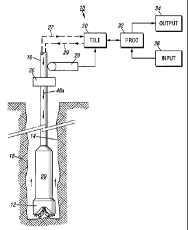
(MWD) embodiment of the system 10 of the present invention. It includes a
downhole subassembly 20 that is suspended within them borehole 14 by a drill
string 16 during drilling of the borehole 14. The downhole subassembly 20 is
positioned as close as practical to the drill bit 12. The drill bit 12 is
rotated by
a downhole motor contained in the downhole subassembly and/or by rotating
the drill string by a surface prime mover to drill the borehole 14 in the
earth
CA 02165017 2005-O1-13
formation 18. For simplicity, the prime mover and other components of the
surface drilling rig are not shown. A preferred embodiment of the downhole
assembly 20 comprising various sensors and devices will be described later
with reference to FIGS. 1 b and 1 c.
Data from the downhole subassembly 20 are telemetered by a downhole
telemetry system (not,shown) in the downhole subassembly 20 to an uphole
telemetry element 30. The uplink data telemetry path is indicated by the
broken line 27. Data from the downhole subassembly 20 are received by the
uphole telemetry element 30 and passed to a surface processor 32. A
processor 32 controls the output 34 such that the parameters of interest are
recorded and displayed in the desired manner which is usually a plot of the
parameters of interest as a function of depth within the borehole at which
they
are determined.
The processor 32 also receives input data from the input element 36
which are telemetered downhole by a downlink telemetry path denoted by the
broken line 29 to the downhole subassembly 20. The use of a two-way
communication system is especially useful in changing reference data such as
offset well data or even sensor response model data during the actual drilling
operation: The system 10 also includes surface depth measurement system;
21
21G501'~
such as a depth measure wheel and associated circuitry 28. A depth
measurement system (not shown) also is included in the downhole
subassembly 20 which enable a downhole computer to more accurately
correlate or compute various sensor measurements and parameters of interest
to their respective depths or true locations within them borehole 14 at which
such measurements are made.
FIG. 1b shows a preferred arrangement of the various devices and
sensors contained in the downhole assembly 20, which is coupled between the
drill bit 12 and the drill pipe 16. The downhole assembly 20 preferably
contains a drill motor or mud motor 210 that is operatively coupled to the
drill
bit 12 via a drive shaft (not shown) disposed in a bearing assembly 212 which
rotates the drill bit 12 when a pressurized drilling fluid 46a is passed
through
the mud motor 210. The bearing assembly 212 supports the radial and axial
forces of the drill bit 12, the downthrust of the drill motor 210 and the
reactive
upward loading from the applied weight on bit. A lower stabilizer 214,
preferably placed over the bearing assembly 212, acts as a centralizer for the
lowermost portion of the mud-motor assembly. In applications requiring
drilling
only vertical boreholes, usually no drill motor is used and the drill bit is
rotated
by rotating the drill pipe by a prime mover at the earth's surface.
The downhole assembly 20 preferably contains a plurality of sensors for
providing measurements for various formation parameters and downhole
conditions, a depth measuring device, and downhole gE~osteering devices that
22
CA 02165017 2005-O1-13
enable altering drilling direction without requiring retrieval of the drill
string.
The embodiment of ]=IG. 1b shows a kick-off assembly 224 and an~ upper
stabilizer 226 placed between the drill motor 210 and the bearing assembly
212. The function and operation of the stabilizers and the kick-off assembly
in the context of this invention will be described later with reference to
FIG. 1 c.
The downhole assembly preferably has a module, generally referred by the
numeral 216, placed above the kick-off subassembly 224 and the upper
stabilizer 226. This module includes a resistivity device 218 for determining
the formation resistivity near and/or in front of the drill bit 12, a gamma
ray
device 220 for measuring the formation gamma ray intensity and an
inclinometer 222 for measuring inclination of the module 216.
The resistivity measuring device 218 preferably is of the type described
in the United States Patent No. 5,001,675.
This patent describes a
propagation resistivity device having one or more pairs of transmitting
antennas
218a' and 218a" spaced from one or more pairs of receiving antennas 218b'
and 218b". Magnetic dipoles are employed which operate in the medium
frequency and lower high frequency spectrum. In operation, the transmitted
electromagnetic waves are perturbed as they propagate through the formation
surrounding the resistivity device.218. The receiving antennas 218b' and
218b" detect the perturbed electromagnetic waves. Formation resistivity is
derived from the phase and amplitude-of the detected signals. The detected
23
CA 02165017 2005-O1-13
signals are processed by a downhole circuit contained within the downhole
assembly 20. The gamma ray device 220 and the inclinometer 222 are suitably
placed along the resistivity measuring device 218 in the module 216.
However, the inclinometer and gamma ray device may be placed at any other
suitable place in the downhole assembly.
The downhole assembly 20 preferably contains an inertial guidance
device, such as a gyroscopic device 230, for determining the position of a
known point in the downhole subassembly 20 during the drilling of the borehole
14: Any other suitable depth measuring device, such as a magnetometer, may
be deployed in the downhole subassembly for the purpose of this invention.
In addition, a formation porosity measuring device and a formation density
measuring device, collectively denoted herein by the numeral 240, are provided
above the drill motor 210.
The present system preferably utilizes a formation porosity measurement
device, such as that disclosed in the United States Patent No. 5,144,126.
This device employs a neutron emission source and a detector for
measuring the resulting scattered neutrons. In use, fast neutrons are emitted
into the surrounding formation. A suitable detector measures the neutron
energy delay due to interaction with hydrogen atoms present in the formation.
The device measures the neutron porosity (f?h) of the formation. Other
examples of nuclear logging devices are..disclosed in United States Patent
Nos.
24
CA 02165017 2005-O1-13
~.
5,126;564 and 5,083,124.
The formation density device preferably is the nuclear density device
disclosed in the United States Patent No. 5,134,285.
Suc h a device
employs a gamma ray source and a detector. In use, gamma rays emitted from
the source enter the formation where they interact with the formation and
attenuate. The attenuation of the gamma rays is measured by a suitable
detector from which density of the formation is determined.
In addition to the sensors described above, the system 10 of the present
invention contains .a number of other sensors, such as sensors for determining
downhole temperatures, pressure, drill bit. rotational speed, fluid flow rate
through the mud motor, etc.
The downhole assembly 20 also contains devices which may be
activated downhole as a function of the downhole computed parameters of
interest alone or in combination with surface transmitted signals to adjust
the
drilling direction without retrieving the drill string from the borehole, as
is
commonly done in the prior art. This is achieved in the present invention by
utilizing downhole adjustable devices, such as the stabilizers and kick-off
assembly. One arrangement of such devices is shown in FIG. 1 c.
Referring to FIG. 1c, the deflection device 250 contains an adjustable bit
subassembly 252 that is coupled directly to the drill bit 12. The drill bit
subassembly 252 has an associated...oontrol means which upon receiving
2ls~o~r~
appropriate command signals causes the drill bit 12 to turn from a current
position 252' to a desired position 252" as shown in the exploded view of FIG.
1c1. Such a device allows changing the drill bit direcaion relative to a fixed
tool. Typically, the drill bit subassembly 250 can effect relatively smaller
changes in the drilling course.
To effect greater drill bit directional changes or steering while drilling,
the
downhole assembly is provided with downhole adjustable lower and upper
stabilizers 214 and 226 and an adjustable kick-off subassembly 224. The lower
and upper stabilizers 214 and 226 preferably have a plurality of associated
independently adjustable pads 214a and 226a as shown in the exploded figures
1c2 and 1c3. Each adjustable pad is adapted to be radially extended and
contracted to any desired position by means within the downhole subassembly
20, such as hydraulic means and/or electro-mechanical means, such as an
electric motor. Alternatively, the stabilizer pads may be made to move in
unison and extended or contracted to desired positions. The kick-off
subassembly 224 is designed so that it may be turned at a deflection point
224a to a desired angle, as shown by the dotted lines 224a' in the exploded
view of FIG. 1c4. The adjustable pads 214a and 226a and the kick-off
subassembly 224 are controlled by their respective means which are responsive
to selected downhole signals executed by a downhole computer and/or signals
transmitted from a surface device. The lower adjustable pads 214, upper
adjustable pads 226 and kick-off subassembly 224 define a three point
26
CA 02165017 2005-O1-13
geometry, which enables steering the drill bit in any desired direction.
.. In the above-described preferred embodiment, the mud motor 210
transfers power to the drill bit 12 via one or more hollow shafts that run
through. the module 216. The hollow shaft enables the drilling fluid to pass
from the mud motor 210 to the drill bit 12. In an alternative embodiment of
the downhole subassembly 20, the mud motor 210 may be coupled below the
resistivity measuring device 218 or~at any other suitable place. The system of
the present invention also includes a suitable means, such as a bypass valve
(not shown), which may be activated by the downhole computer during the
drilling operation to control the fluid flow through the mud motor and, thus,
_
control the rotational speed of the mud motor and. hence the drill bit 12.
The various components of the downhole assembly 20 are preferably
interconnected modules, each such module containing various sensors and
devices. Each module is contained in a fluid tight housing which shields the
internal elements thereof from the borehole environment. A modular
construction is described in the U.S. Patent No. 5,456,106,
FIG. 1d the system of the present invention in a wireline embodiment,
generally designated by numeral 10'. The downhole subassembly 20 is
suspended within borehole 14 by the wireline 17. Casing 19 is positioned in
the upper portion of the borehole 14. The annulus between the casing 19 and
the borehole 14 is filled with cement which provides a hydraulic and pressure
27
2ls~a~~
seal. A lubricator 22 is affixed to the top of the casing 17 thereby providing
a conduit through which the wireline 19 passes and also providing a means of
containing any pressure within the borehole 14. The wireline 17 passes over
a calibrated depth measure wheel 28' and is attached to a draw works (not
shown). The depth measure wheel 28' performs the same functions as the
depth measure wheel 28 described previously in the MWD embodiment of the
invention. The draw works cooperates with the wireline to convey the
downhole subassembly 20 along the borehole 14 in a manner well known in the
art. As mentioned previously, the wireline also provides a communication path
between the downhoie subassembly 20 and the surface telemetry unit 30.
FIG. 2a shows a functional block diagram of they major elements of the
downhole assembly 20 and further illustrates with arrows the paths of
cooperation between such elements. It should be understood that FIG. 2a
illustrates only one arrangement of the elements and one system for
cooperation between such elements. Other equally effective arrangements may
be utilized to practice the invention. A predetermined number of discrete data
point outputs from the sensors 52 are stored within a buffer which, in FIG.
2a,
is included as a partitioned portion of the memory capacity of a computer 50.
The computer 50 preferably comprises commercialh~ available solid state
devices which are applicable to the borehole environment. Alternatively, the
buffer storage means can comprise a separate memory element (not shown).
The sensor response relationships or "models" are stored within memory 48
28
21G501'~
which preferably comprises commercially available solid state storage devices
suitable for the borehole environment. In addition, other reference data such
as seismic data, offset well log data statistics computed therefrom, and
predetermined drilling path also are stored in the memory 48. A two way
communication link exists between the memory 48 and the computer 50. The
responses from sensors 52 are transmitted to the computer 50 wherein they
are transformed into parameters of interest using methods which will be
detailed in a subsequent section hereof.
The computer 50 also is operatively coupled to certain downhole
controllable devices d1 - dm, such as adjustable stabilizers and kick-off
subassembly for geosteering and to a flow control device for controlling the
fluid flow through the drill motor for controlling the drill bit rotational
speed.
The sensors 52 are usually axially spaced within the downhole
subassembly 20 and operate simultaneously. The sensors 52, therefore, do not
provide measurement corresponding to the same borehole location at the same
time. Therefore, before combining the sensor data, the computer 50 shifts the
raw sensor data to a common reference point, i.e. depth correlates such data,
preferably by utilizing depth measurements made by the downhole depth
measurement device contained in the downhole subassembly 20. Also,
different sensors 52 usually do not exhibit the same vertical resolution. The
computer, therefore, is pragrammed to perform vertical resolution matching
before combining the sensar data. Any suitable method known in the art can
29
21s5o~~
be used to depth shift and resolution match the raw sensor data. Once
computed from the depth shifted and resolution matched raw data, the
parameters of interest are then passed to the down hole portion of the
telemetry system 42 and subsequently telemetered to the surface by a suitable
uplink telemetry means illustrated conceptually by the broken line 27. The
power sources 44 supply power to the telemetry element 42, the computer 50,
the memory modules 46 and 48 and associated control circuits (not shown),
and the sensors 52 and associated control circuits (not shown). Information
from the surface is transmitted over the downlink telemetry path illustrated
conceptually by the broken line 29 to the downhole~ receiving element of
downhole telemetry unit 42, and then transmitted to the storage means 48.
In the MWD embodiment, the telemetry transmission path between the
downhole telemetry unit 42 and the uphole telemetry unit 30 is the drilling
mud
column in the preferred embodiment.
FIG. 2b shows a generalized flow chart of determining parameters of
interest downhole and the utilization of such parameters in the context of
this
invention. The individual sensors, such as the porosity, density, resistivity
and
gamma ray devices obtain base sensor measurement and calculate their
respective parameters. For example the neutron porosity device may provide
the value of the formation nuclear porosity (1?~~) and the density device may
provide the formation density. Such sensor measurements are retrieved by the
computer according to programmed instruction for determining the parameters
~~s~o~~~
of interest. The computer receives depth measurements from the downhole
depth device 230 (FIG. 1b) and/or from the surface processor 32 (FIG. 1a) and
correlates the sensor measurements to their respective true borehole depth as
shown by the box 314. The downhole computer then matches the resolution
of the depth correlated measurements. For example, neutron porosity on a
sandstone matrix at a given depth resolution is matched to other sensor
measurements in the downhole assembly.
The computer then transforms or convolves .a selected number of
measurements to determine desired parameters of interest or answers as
shown by the block 318. The parameters of interest may include parameters
such as the water saturation (SW), true formation porosity obtained from the
neutron porosity f~X~ and the formation density from the density device,
flushed
zone saturation, volume of shale in the formation (Vsh),. recovery factor
index
( "RFI"), amount of the drill string direction deviation from a desired
borehole
path, etc. The computer also may be adapted to compare the borehole
formation logs with prior well logs and seismic data stored in downhole memory
and to cause the deflection elements (see FIG. 1b) to adjust the drilling
direction. The computer 50 transmits selected answers to the surface 330 and
takes certain corrective actions 332, such as correcting the drilling
direction
and adjusting the drill bit rotational speed by adjusting the fluid flow
through
the drill motor. The surface processor 32 receives the data from the downhole
computer via the downhole telemetry and may send signals downhole to alter
31
2lfi~~l~'
the downhole stored models and information, causing t:he downhole computer
to take certain actions as generally shown by block 334. In one embodiment,
the system described here is a closed loop system, in that the answers
computed downhole may be adapted to cooperate with surface signals and may
be utilized alone or in conjunction with external information to take certain
action downhole during the drilling operations. The computed answers and
other information is preferably stored downhole for later retrieval and
further
processing.
For clarity and ease of understanding, the determination of parameters
of interest downhole from the various downhole assembly sensors will now be
described by way of a examples. It will, however, be understood that the
present invention is not limited to such specific exampNes.
DATA ACQUISITION AND PROCESSING
For ease of understanding, an overview of the general data acquisition
and processing methodology used in this invention is described first followed
by details of the methodology.
The downhole computer 50 is programmed to process measured data
from the multiple sensors of different types using predetermined sensor
response relationships. As an example, assume that the downhole
subassembly contains sensors for detecting scattered gamma radiation spectra,
32
thermal neutron flux, attenuation and phase shift of electromagnetic
radiation,
acoustic travel time, and an inclinometer and a three axis accelerometer. The
response characteristics for any particular combination of sensors is
preferably
formulated in the form of a response matrix. The response matrix is generated
for any particular combination of sensors either with measurements within
environmental test formations of known borehole and formation characteristics,
or mathematical modeling of the tool sensor responses under known conditions,
or both. The response matrix is programmed within the downhole computer.
The response matrix may change as borehole conditions change. The current
invention provides means far changing the response matrix while drilling as
will
be disclosed in a following section. During actual drilling operations, raw
data
are recorded by one or more sensors during a sample tune period. These data
are next correlated to a common measure point and then arranged into a data
matrix by the downhole computer and stored temporarily within the computer
along with the depth of the common measure point at which the sensor
measurements were made. The parameters of interest are then determined
from the product of the response matrix and the data matrix, with the matrix
multiplication being performed within the downhole computer.
For purposes of illustration, further assume that the response matrix
contains m rows and n columns and that the data matrix is one dimensional
containing "m" rows. The parameter matrix would be a one dimensional matrix
containing "n" rows. Each element of the parameter matrix represents a
33
2~.65~~. 'l
computed parameter of interest. The computed parameters of interest and
corresponding depth are then telemetered to the surface using a system such
as a mud-pulse telemetry system and recorded at the surface as a function of
depth within the borehole, or alternatively stored in a first downhole memory
for subsequent retrieval at the surface, or simultaneously transmitted to the
surface and stored in the first downhole memory me<~ns. Using the sensor
array defined above, the elements of the parameter matrix might represent the
resistivity, dielectric constant, bulk density, effective porosity and
hydrocarbon
saturation of the formation, the diameter of the borehole and the azimuth and
inclination of the downhole subassembly.
It should be understood that m, the number of measured raw data points,
is equal to or greater than n, the number of parametE~rs of interest. In the
examples of multiple phase and attenuation measurements, multiple gamma ray
and neutron spectral measurements, and full wave acoustic measurements, the
number m is orders of magnitude greater than n. It should also be understood
that a plurality of raw data rneasurements can be obtainE~d from a single
sensor
such as a single electromagnetic transmitter-receiver array with the
transmitter
operating at a plurality of frequencies. Using current: MWD telemetry and
storage capacities, only the n parameters of intere:>t can be effectively
telemetered or stored thereby requiring that each parameter of interest be
computed downhole at each depth interval. Bandwidth and storage limitations
prevent telemetering and storage, respectively, of the raw data measurements
34
~16~~i1~r
m.
Methods other than the previously described matrix manipulation method
may also be used to combine raw sensor data with operational characteristics
of the sensors to obtain parameters of interest. Parallel processing computing
means are ideally suited for processing or "reducing" large amounts of
measured data to relatively small amounts of processed or '"answer" data.
Emerging neural network technology is likewise suited for performing the
stated tasks in a most efficient manner.
The processing of raw downhole sensor data will be illustrated using a
relatively small number of downhole sensors 52. Assume that the downhole
subassembly 20 comprises:
(1) a natural gamma ray sensor which measures the total or gross
natural gamma radiation emitted by the formation;
(2) a spectral gamma ray sensor which measures natural gamma
radiation emitted by the formation falling within a plurality "wr" of energy
ranges or energy "windows ";
(3) a chemical source of neutrons such as Americium-beryllium
(AmBe) with a thermal neutron detector axially spaced a relatively short
distance from the source of neutrons;
(4) the same type source of neutrons with a thermal neutron detector
axially spaced a relatively long distance from the source of neutrons;
(5) an isotopic source of gamma radiation such as cesium-137 ('3'Cs)
21~50.I'~
with a gamma ray detector axially spaced a relatively short distance from the
source of gamma radiation with which scattered gamma radiation from the
isotopic source is measured;
(6) the same type isotopic source of gamma radiation with a gamma
ray detector axially spaced a relatively long distance from the source of
neutrons with which scattered gamma radiation from the isotopic source is
measured; and
(7) an acoustic sensor for measuring the distance or "stand-off"
between the wall of the downhole subassembly 20 and ithe wall of the borehole
14.
The gross gamma ray activity of the formation is used as an indicator of
the amount of shale within the formation and the spectral natural gamma ray
detector is used to classify types of shale and to aid in the identification
of
other constituents of the formation. The neutron sourcE~ and short-spaced and
long-spaced thermal neutron detectors are used as an indicator of formation
porosity. Likewise, the gamma ray source and long and short spaced gamma
ray detectors are used to measure the bulk density of the formation which
measurements, in turn, is used to make a second detE~rmination of porosity.
Finally, stand-off of the downhole subassembly is .determined using the
acoustic stand-off sensor. These stand-off measurements are then used to
correct the porosity and bulk density measurements for the adverse effects of
sta nd-off.
36
~lfi~fl~,
Individual Sensor Responses
The responses of each of the above sensors are, hawever, not a sole
function of the parameter of interest being calculated from the response. As
probably the most simple example of this phenomena, the response of the
gross natural gamma ray sensor is not only a function of the shale content of
the formation but also a function of the other constituents of the formation
which emit gamma radiation and, to a lesser extent, a function of the porosity
of the formation.
Details of the data processing methods will now be presented using the
following terminology:
~e = the effective porosity of the formation;
Vsh = the shale fraction of the formation;
fq = the fractional mineralogical constituents of the formation where q = 1,2,
..., p; and
~e + Vsh + f, + f2 + ... fp = 1Ø
The responses of the various sensors used in the example are:
C9, = the count rate measured by the gross natural gamma ray detector;
Cs~,," = the count rate measures by the spectral natural gamma ray detector in
window v = 1,2, ..., w;
C~,s, = the count rate measured in the short spaced thermal neutron detector;
C~,,s = the count rate measured in the long spaced thermal neutron detector;
37
2ls~o~ '~
Csgr.ss = the count rate measured in the short spaced scattered gamma ray
detector;
C'sgt.ls = the count rate measured in the long spaced scattered gamma ray
detector; and
Th - the series of acoustic travel times used to compute downhole
subassembly stand-off.
Subassembly stand-off is preferably measured by (a) employing a
transducer to transmit a train of acoustic pulses azimuthally around the
borehole and (b) measuring the travel time of each pulse as it reflects from
the
borehole wall and returns to the transducer.
As stated previously, the response of the gross natural gamma ray
sensor is not only a function of Vsh but also a function of fde and the
natural
gamma ray activity of the rock matrix constituents fq. For brevity, the
constituents fq will be referred to as a group representing the rock matrix
using
the symbol "Ma". Stated mathematically, C9,(V,,,,O.,Ma~ = F(Vsh,~~,Ma) where
F(Vsh,~e,Ma) is a functional relationship illustrated hypothetically in FIG
3a. The
shale fraction Vsh is plotted on the ordinate 80 as a function of measured
count
rate C9~ which is plotted on the abscissa 70. This functional relationship is
presented for three different rock matrices May, Ma2 and Ma3 represented by
the curves 64, 66 and 68, respectively. The three curves are for formations
with fd~ = 0 and are also for a specific type of shale with a given gamma ray
activity per unit volume. All curves converge at point 60 at Vsh = 1.0 ( 100%
38
21fi5fl~'l
shale formation) with a corresponding count rate identified by the numeral 62.
For a different type of shale, the point of convergence for Vsh = 1.0 might
yield
a count rate shale which is greater or less than the count rate identified by
the
numeral 62. As the porosity of the formation increases, the functional
relationship between Vsh and C9, changes. Using the matrix Ma3 as an example,
the curve will be displaced to the left with increasing ~e as depicted by the
broken line curve 74. This, of course, assumes that the pore space of the
formation is filled with fluid which is lower in gamma ray activity per unit
volume than the rock matrix Ma3. Based upon the hypothetical example shown
in FIG. 3a, the functional response "model" for the gross natural gamma ray
sensor can be written as
Cg~(Vsn,~e~Me) = F(Vsn,~.,M~)
- K9~ I(a,Vsn '+ b,Vsh2) + c,Ma(1. 0- ~~ - Vsh)1
where K9~ is a constant depending upon the size and efficiency of the gamma
ray detector, a,, b,, and c, are constants, and Ma is ithe gamma count rate
emitted per unit volume of the rock matrix. The terms Kg,, a,, b~, and c~ are
"known" calibration constants which are either determined by operating the
sensor in known test formations or are calculated using mathematical models
of the sensors. The terms Vie, Vsh and Ma (or more specifically the major
constituents fq of the rock matrix M,) are the "unknown" parameters of
interest
to be determined. Cg, is, of course, a "measured" quantity.
FIG. 3b illustrates a hypothetical functional relationship between the
39
21~65~~
count rate C~,ss measured by the short spaced thermal neutron detector and
~,~.
Curves 92 and 94 illustrate this relationship for two rock matrices Me~ and
Ma2,
respectively. For both curves Vsh = 0.0 and there is no stand-off between the
downhole subassembly 20 and the wall of the borehole 14. Defining dso as the
stand-off distance, dso = 0.0 for both curves 92 and 94. As Vsh increases in
the formation, the curve will move to the left as depicted by the broken curve
96. Most shales contain neutron absorbers in a greater concentration than
most rock matrices. For a given true effective porosity, the measured count
rate C~,~S will, therefore, decrease as Vsh increases moving the curve to the
left
as illustrated. As the downhole subassembly stands-off from the borehole wall
in a liquid filled borehole, the sensor "sees" the intervening liquid as a
portion
of the formation with 100% porosity. As a result, the measured count rate
decreases for a given true formation porosity as d$a increases. Using as an
example the curve 94 for the rock matrix Ma2, the curve will move to the left
with increasing dso as depicted by the broken line curve 9$. The measured
count rate C~,sS is, therefore, a function of fr~~ as well as Vsh, Ma and dso.
There
are other parameters which affect C~,SS such as the "excavation effect" as
presented by F. Segesman and O. Liu (SPWLA Symposium, Dallas, May 2-5,
1971 ), but this effect is relatively small. In addition, a gas filled
borehole will
drastically affect the response of the thermal neutron detector although this
is
not common in MWD operations and relatively rare in wireline operations. For
purposes of illustration, it can be stated mathematically that
21fi5~~.~
Cn.ss(~.~Vsh~Ma,dso) = F(f~e~Vsh.Manso) where
(2) F(~~,Vsh,Ma,dso) = K~.ss ((az e~b2H~ + c2 ea2~sh)
+ e2F(Ma,Vsh+ f2F(dso,f~~)1
where K~,ss is a known constant which is a function of the neutron source
strength and the thermal neutron detector size and sensitivity, and a2, b2,
c2,
d2, e2, and f2 are also "known" calibration constants either measured by
operating the sensor in known test formations or computed by mathematical
modeling of the sensor. F(M,, Vsh) is a known functional relationship
expressing
the effects of Ma and V~h upon C~,ss, and F(dso,fd,) is a known functional
relationship expressing the effects of dso and He upon C~,55.
Following procedures outlined above, specific sensor models are obtained
for the remaining sensors in the illustrative example and, for brevity, will
be
summarized as follows using previously defined nomenclature:
(3) Cs9,,"(Vsh,Ple,Ma) = F,~ (Vsh~f~B,Ma) for v = 1,2,...w
C~.n(1~~.Vah~Ma,dso) = F~(~,~,Vsh,Ma,dso)
Cagr, ss(~e~Vsh~Ma,dso,dmud) - F(~e~VshrMa,dso,dmud)
Csgr.ls(~e~Vsh~Ma,Clso.dmua) = F~(~~~Vh~M~~Ds°.dm~a
dso(T~~dm~a) - F(T~~dm~a) for i = 1, ... h
where dm~a is defined as the density of the drilling mucl.
Combination Sensor Responses
To continue the data processing example, assume that m raw sensor
41
2~s~oi~
responses are measured and that the parameters of interest are l~Je, Vsh and
three mineralogical constituents f,, f2, and f3 which include the rock matrix
Ma.
In the preferred embodiment, the individual sensor response models as defined
in the equation set (1 ) through (7) are rearranged into a system response
model
which, for the example being presented, can be written as a 5 x m system
response matrix [S] such that
($) IPl = (S1 x (Dl
where [D] is the m measured raw sensor responses expressed as a m x 1 data
matrix and [P] is a 5 x 1 matrix comprising the five parameters of interest,
namely f~~, Vsh, f~, f2, and f3. The system response matrix [S] is stored
Within
memory 48. The matrix multiplication of equation (8) is performed within the
computer 50 and only the five exemplary parameters of interest are telemetered
to the surface, or stored within memory 46 for subsequent retrieval, or both.
The number of energy windows used in the spectral natural gamma ray system
is usually at least three but can be as great as ten or twelve or even more.
The
number of acoustic travel time measurements Th, for each stand-off
determination can be quite large. These measurements combined with other
sensor measurements discussed in detail can yield data rnatrices [D]
containing
fifty or more elements (i.e. m ~ 50). Even using the relatively small subset
of
sensors, it is apparent that downhole processing oi~ raw data to obtain
parameters of interest reduces the volume of data that nnust be telemetered or
stored by more than an order of magnitude. As an e~c:ample, the previously
42
216501
mentioned simplified subsurface map or matrix can be updated and use
combined values representing specific variations in lithology with minimal or
reduced amounts of memory.
As noted earlier, the downhole subassembly also contains an array of
multiple electromagnetic transmitters and multiple receivers. Measurements
from these arrays are used primarily to determine the resistivity and
dielectric
constant of the formation which, when combined with other parameters, yield
formation hydrocarbon saturation. If one or more acoustic transmitters and
receivers are employed to obtain a third, independent porosity determination,
large quantities of raw data will be used to compute a single "acoustic"
porosity data point. If, therefore, a full set of formation evaluation and
directional sensors are employed in the downhole subassembly 20, it would not
be unusual for the number of raw data measurements m to exceed the number
of parameters of interest n computed from these measurements by several
orders of magnitude. Considering the available bandwidth available in current
MWD systems, it is apparent that the transmission and processing of raw data
at the surface while preserving reasonable vertical resolution would not be
possible. Wireline quality "combination" logs can be obtained from the
responses of sensors of multiple types only if processing is performed
downhole. The same applies for storing data for subsequent retrieval. Current
MWD downhole storage capacities can handle only computed parameters of
interest rather than raw data.
43
The computed parameters of interest may be further used by the
downhole computer as an input to determine other parameters of interest. For
example, V,h may be used to discriminate porosity and resistivity data to
determine whether the formation being logged or drilled is a reservoir or non-
reservoir rock. Vsh also may be used to as a determinate to modify the
transmission sequence of data uphole. For example,, when Vsh is below a
predefined value, say 0.2, the transmission sequence would be preferential to
convolved answers and when VS,, is above the predetermined value, then it may
be desirable to transmit sensor data from a selected sensors for use in real
time
by the surface processor. Additionally, important answers such as water
saturation "SW", flushed zone saturation "Sxo" and recovery factor indicator
"RFI", which are typically determined by utilizing wireline measurements, may
be determined downhole during the drilling operations by utilizing other
parameters of interest. An example of determining such answers is given
below.
Determination of SW, Sxo and RFI is dependant upon the porosity of the
formation. The formation porosity fd' may be derived from the nuclear porosity
device and the density device contained in the downhole subassembly as;
~d - Vrma ' PbOIPma ~ pfd
where typical matrix densities pme for various rock types and fluid densities
pf
for various fluid are predefined. p6 is the bulk denaity determined by a
downhole sensor. The determination of the density porosity from the density
44
~ls5o~~~
assumes a knowledge of the matrix density and the fluid density. The matrix
density may be determined from a density/neutron cross-plot or from a
density/photoelectric cross-plot, which methods are known in the art. Matrix
pme and fluid pf densities may be preprogrammed and/or downloaded real time
into the downhole computer. This enables updating such correction and
characterization parameters as required, which is important in MWD
applications, because the downhole environment constantly changes during the
drilling operations.
A reasonable approximation of true porosity fdt in Iliquid-filled zones is the
average of the porosities determined by the neutron (k7~) and density (~d)
measuring devices, i.e.,
~t = (~~ + fd~d)/2
An approximation of true porosity in gas-bearing formations is
2 + ~d2~/2~0.5
Determination of gas bearing formations may be effected downhole by
recognizing the "gas crossover effect" in reservoir rock exhibited on the
neutron
and density porosity logs. The presence of neutron - clensity crossover may
be configured as a single bit flag for transmission uphole and used as an
input
for selection of a porosity determination relationship.
With the downhole determination of the true porosity fit, the following
answers may determined as:
SW = o (~~~o.5/~t
~1650~'l
~~t) ~Rm~Rxo)~.5
RFI = Sxo - S 1-SW
where Rt, true resistivity, is measured from the deepest reading of the
resistivity device, and RW, resistivity of the water pores, is preprogrammed
in
the downhole computer and may be updated as the drilling proceeds. Rxo,
resistivity of the invaded or flushed zone, is measured from the shallowest
reading of the resistivity device. The element "c" is a constant having
different
values for different rocks. For example c is 1.0 for Ilimestones and 0.9 for
sandstone. Rmf, resistivity of the mud filtrate, for various mud types may be
preprogrammed in the downhole computer and/or measured at the surface and
transmitted during the drilling operations. The value of the mud filtrate
resistivity Rmf is adjusted for downhole temperature effect by the computer
prior to its use by known empirical relationships, such as:
Downhole R,"f = Surface Rmf (T3 + 6.77)/ (Td + 6.77)
where Ts and Td, respectively, are the surface and downhole temperatures.
Advantages of the invention with respect to .determining formation
evaluation parameters over the prior art MWD systems are numerous, some of
which are outlined below. Other advantages will become apparent in the
application relating combining the downhole computed parameters of interest
with reference data and taking downhole corrective actions as a function of
such parameters.
( 1 ) A plurality of formation-evaluation sensors can be used since data
46
~165Q:~
processing is performed downhole and the use of limited MWD telemetry and
storage is optimized. Parallel, rather than serial, processing of data from
multiple types of sensors can be employed. Serial processing is common in
both current MWD and wireline systems. As a simple example, formation
porosities computed from acoustic travel time, neutron porosity and bulk
density measurements are currently processed serially in that environmental
corrections such as borehole size effects are first made to each measurement
and the environmentally corrected determinations are then combined to obtain
previously discussed formation lithology and improved formation porosity
measurements. The current invention allows the correction of all sensor
measurements in parallel for environmental effects and computes the desired
formation parameters simultaneously since the response matrix of the sensor
combination is used rather than three individual response relationships for
the
acoustic, neutron porosity and bulk density measurements, with subsequent
combination of parameters individually corrected for environmental effects.
This reduces propagation of error associated with environmental corrections
resulting in a more accurate and precise determination of parameters of
interest. Parallel processing is possible only through the use of downhole
computation because of data transmission and storage limitations.
(2) Only computed formation parameters of interest, rather than the
raw sensor data, are telemetered or stored. As a result, telemetry and storage
capacity is also available for the determination of additional, non-formation
47
zss5o~~
type, yet critically important parameters, such as drilling dynamics and the
operational status or "health" of all downhole measuring systems. This reduces
drilling costs and insures that measured data and resulting computations are
valid.
(31 Since downhole computation reduces the volume of data that
must be telemetered to the surface and since the telemetered data are
parameters of interest, real-time decisions can be made based upon these
measurements. As an example, in the drilling of horizontal boreholes within a
selected formation, real-time formation parameters are transmitted to the
surface. If these parameters indicate that the drill bit is approaching the
boundary of the selected formation or has passed out of the selected
formation,
the logs indicate this excursion in real time so that the driller can take
remedial
steps to return the bit to the selected formation. This is referred to as
"geosteering" in the industry and, again, is optimized by the current
invention
in that downhole computation and subsequent telemetering of only parameters
of interest does not exceed available band width.
(4) The quality of combination-type formation evaluation parameters
which can be determined with the current invention are comparable to wireline
measurements and thereby eliminate partially or completely the need to run
wireline logs at the completion of the drilling operation. This results in a
substantial cost savings in either the completion or abandonment of the well.
48
21650I'~
APPLICATIONS OF THE SYSTEM USING REFERENCE DATA
The following is presented as an overview example of the correlation of
parameters of interest determined within a drilling well with external
reference
data. For purposes of illustration, assume that the MWD subassembly 20
contains a plurality of sensors 52 whose responses can be combined in real-
time using previously discussed methods to obtain the parameters of interest
of formation porosity, lithology and resistivity. Assume further that
reference
data comprises porosity, lithology and resistivity logs from surrounding
wells,
as well as the dip and strike of certain formations of interest. This
information
is stored in the second downhole storage means 48 which will be referred to
as the reference data memory. The reference data contains sufficient
information to predict the depth within the drilling well at which formations
of
interest will be penetrated. Real-time measures of porosity, lithology and
resistivity in the drilling well are continuously compared or correlated with
porosity, lithology and resistivity, along with formation strike and dip
predicted
by the reference data. The degree of correlation or correlation coefficient is
telemetered to the surface. As long as correlation remains good, the driller
is
assured that the well is being drilled within the targeted fault block and
that a
fault plane has not been encountered. Should, however, the correlation
between the drilling and reference parameters suddenly degrade, the driller
must surmise that an unexpected fault plane has been penetrated. Changes in
49
ms5a~~
the drilling program can be made accordingly at the time the problem is
encountered. Without real-time correlation of drilling and reference data, a
significant amount of borehole could be drilled within the unexpected fault
block resulting in wasted time and money.
Specific examples of combining the stored reference data with the
parameters of interest measured during the drilling operations will now be
described. In the following examples, reference data will be of the form of
offset log data and seismic data. F1G. 4a illustrates the geographical
location
of three existing wells identified by the numerals 100, 110 and 120. North is
specified by the arrow 99. Combination natural gamma ray and resistivity logs
measured in the existing wells 100, 110 and 120 are shown in FIG. 4b across
the shale sand sequence of interest and are identified in general by the
numerals 100', 110' and 120', respectively. More specifically, the natural
gamma ray log 101 measured in well 100 shows the top of the sand labeled
"A1 " at a depth indicated by the numeral 102. The same gamma ray log
shows the top of a second sand labeled "B1 " at a depth indicated by the
numeral 104. The resistivity log measured in the same well and identified by
the numeral 103 indicates no increase in resistivity in the A1 sand indicating
that the sand is filled with saline water. The measured resistivity does show
an increase in resistivity 107 in the top of the B1 sand indicating that the
sand
is partially saturated with oil with an oil-water contact at the depth 106.
Turning next to the combination log 110' run in well 110, the A1 sand is again
216~01'~
seen on the gamma ray log 111 but with a top at a depth 112 which is
shallower than the corresponding A1 sand top in well 100. The B1 sand is also
clearly delineated by the gamma ray log 111 with a top at the depth 114 which
is likewise shallower than the top of the B1 sand in well 100. The resistivity
log 113 measured in well 110 shows an increase in resistivity 115 in the A1
sand indicating oil with an oil-water contact at the depth 116. The increase
in
resistivity 117 in the B1 sand likewise indicates partial oil saturation with
an oil-
water contact again at a depth 106. Finally, the combination natural gamma
ray and resistivity log measured in well 120 and identified in general by the
numeral 120' indicates the top of the A1 sand again at the depth 112, the oil-
water contact within the A1 sand again at the depth 116, the top of the B1
sand at the depth 114, and the oil-water contact within the B1 sand at the
depth 106.
By comparing the logs 100', 110' and 120' with the geographical
locations of the three wells 100, 110 and 120, it is apparent that the beds
are
dipping in an upward direction toward the north east as indicated by the arrow
140. It is desirable to locate the well to be drilled "up-dip" from the
existing
wells, and this optimum location is denoted by the numeral 130 in FIG. 4a.
FIG. 4c depicts a cross section X-X'-X" which includes existing wells 100 and
110 and the drilling well 130. The surface of the earth is identified by the
numeral 98. The proposed path 130' of the drilling well penetrates the A1
sand where the bottom of the sand is above the oil-water contact at the depth
51
21fi50~'~
116. Likewise, the proposed path of the drilling well penetrates the B1 sand
where the bottom of the sand is above the oil-water contact at the depth 106.
This location will, of course, maximize production from both sands.
It is desirable to store the entire logs 100', 110' and 120' within the
memory 48 of the downhole subassembly 20 such that the MWD logs 131 and
133 obtained while drilling the well 130 can be continuously compared with the
"reference" logs. This continuous comparison assures the driller that the
borehole is, in fact, being drilled along the planned path 130' and that no
unexpected discontinuities have been encountered. Available memory 48 will
usually prohibit the storing of the entire reference logs. Alternatively a
much
smaller set of reference data can be stored within the memory 48. This
abbreviated set of reference data includes the depths of the tops and bottoms
of the formations of interest, the strike and dips of these formations, the
projected tops and bottoms of these formations at the points of intersection
with the drilling well, and the log readings within the formations of interest
and
within adjacent beds. As an example, a combination MWD gamma ray and
resistivity log, indicated in general by the numeral 130', shows first that
the
drilling operation has reached a depth 136. In addition, the MWD gamma ray
log 131 and the MWD resistivity log 133 indicate that the A1 sand has been
penetrated with the top "up dip" at a depth 132 as predicted from the
extrapolation of the offset log data. The driller, based upon MWD
measurements and projections and log readings from offset log data, is assured
52
~'16!~!~ ~ y
that the drilling operation is proceeding as planned and that no formation
discontinuities have been encountered.
Attention is now turned to the use of offset well log and seismic
information as reference data. The locations of existing wells 100, 110 and
120 are again shown in FIG. 5a with north being indicated by the arrow 99 and
the northeast direction of upward dip of the formations of interest again
being
illustrated by the arrow 140. In this example, the formations are not
continuous but are interrupted by a fault 141. The top of the fault plane is
shown in FIG. 5a and lies between the locations of the existing wells and the
location of the drilling well 130'. FIG. 5b again depicts the cross-sectional
view
X-X'-X" which illustrates the down-thrust portion of the fault to the
northeast.
The A1 sand is sealed from its counterpart A2 sand on the down-thrust side of
the fault 141. The B1 sand is likewise sealed from its counterpart B2 sand on
the down-thrust side of the fault.
The drilling well 130' has been drilled to a depth indicated by the numeral
136' with the target depth being indicated by the point 180 and the intended
path for the borehole being designated by the broken line 178. The well plan
is to penetrate the oil bearing portions of the A1 and B1 sands near the fault
plane which will maximize the up dip production on the down-thrust side of the
fault 141. Prior to drilling, it is not known whether the A2 sand contains
oil.
As in the previous example, pertinent reference data from the logs of wells
100, 110 and 120 are stored within the memory 48 of the downhole
53
2165U1~~
subassembly 20. Preloaded offset well data can be enhanced by the
aforementioned "look ahead" sensor measurements. In addition, coordinates
of the fault plane are also stored within memory 48. Tops of the A2 and B2
sands, which can be determined with seismic data with much less resolution
than from log data (if it were available), are also stored within the memory
48.
FIG. 5c illustrates the MWD gamma ray and resistivity logs identified by the
numerals 231 and 233, respectively. The current drilling depth is designated
by the numeral 136'. The excursions 240 and 245 of the gamma ray log
indicate that the A1 and A2 sands were penetrated as predicted by the offset
log and seismic data. The low resistivity reading in the A2 sand indicates
that
this sand is saturated with saline water, at least at the intersection with
the
borehole 130'. MWD log readings predicted by the stored log and seismic
reference data from the current drilling depth 136' to the final or "total"
depth
180 are illustrated as broken curves 248 for the gamma ray log and broken
curve 246 for the resistivity log. If the actual MWD log readings agree with
the
predicted gamma ray and resistivity log readings 248 and 246, respectively,
the
driller is assured that the borehole is tracking the targeted path. Should
deviation between actual and predicted log readings occur, the driller has
early
warning that either drilling has deviated from the desired direction or
unexpected geological anomalies have been encountered.
In the foregoing examples, only gamma ray and resistivity measurements
were used as parameters of interest for brevity and that the invention as
54
2ls~o~~
disclosed allows many additional parameters of interest to be measured. In
addition, the two-way communication feature described previously allows
different parameters of interest to be selected while drilling and allows the
response models of the sensors to be changed while drilling should unexpected
geological features be encountered while drilling. In addition, drilling
direction
can be adjusted based upon geophysical parameters measured while drilling.
Some of the advantages over prior art of the embodiment of the
invention in which parameters of interest are correlated downhole with
reference data are briefly summarized as follows:
(1 ) The penetration of unexpected geological anomalies such as fault
planes and lenses can be detected in real-time allowing remedial steps to be
taken more quickly and cost effectively.
(2) Seismic data can be tied in with logging data during the actual
drilling of the well.
(3) Depth control of extended drilling within a given well can be
obtained to a high degree of accuracy by using data measured within the given
well during prior passes as reference data.
(4) Drilling dynamics measurements from prior passes within a given
well can be used as reference data to optimize the drilling program to extend
the well to total depth.
(5) Indications in real-time that the target formation has been reached
can be obtained by correlating reference data comprising geophysical
properties
21fi501 d
of the target formation with corresponding measured parameters of interest.
(61 The accuracy and precision of computed parameters of interest
within the drilling well can be optimized by storing additional sensor
response
matrices as reference data. If dictated by changes in environmental
conditions,
an alternate sensor response matrix can be used to compute improved
parameters of interest.
(7) Acoustic measurements provide the ability to obtain information
about the subsurface formations lying ahead of the drill bit. Such
measurements can be used to preset or precondition other shallow
measurements prior to the drill bit entering such zones. In addition, a simple
form of subsurface map or matrix can be created to enhance the preset
parameters for those shallow investigating sensors.
The use of the system of the invention for altering the drilling direction
without retrieving the drill string will now be described in more detail. In
one
embodiment the downhole computer has stored therein the predetermined
borehole path that is adapted to be updated by surface transmitted signals.
During the drilling of the borehole 74, the downhole computer continually
determines the true depth of the drill bit preferably from the downhole
computed depth measurements as described and determines any deviation
therefrom. If the deviation is greater than a predetermined amount, it causes
one or more of the downhole deflection devices, such as the adjustable
stabilizer pads and the adjustable bend, to correct the drilling direction.
FIG. 6a
56
~1651~:~"~
shows a functional block diagram for controlling the deflection devices. The
directional response function model for the particular downhole assembly being
used for drilling the borehole is programmed in the computer. The computer 50
cooperates with the sensing and control circuit 402 to cause the desired
actuating control circuits 404a-n to control their respective devices 406a-n,
in
response to programmed instructions and/or surface transmitted signals during
the drilling operations. The particular deflection devices chosen to adjust
the
drilling direction and the amount of change effected by each such device
depends upon the nature of the desired change. Thus, the system makes
closed loop decisions to adjust the downhole assembly to drill along a desired
path and/or along a particular pay zone.
FIGS. 7a-a show another example illustrating how the present system
may be utilized maintain the drilling within a desired pay zone 500. FIGS. 7a-
c
respectively show examples of the gamma ray logs as a function of the
borehole depth, preferably determined downhole. FIG. 7d shows water
saturation and RFI logs computed by the downhole computer as described
earlier. In FIGS. 7a-d, the parameter values are shown along the vertical
direction as a function of the borehole depth or location. Track 452 is the
gamma ray log with a shale bed at the top followed by a mixed sand shale
(fining) upward) sequence followed by a clean sand starting at depth of about
160 depth units. Tracks 454 and 456 respectively show the shallow and deep
resistivity values. Track 458 and 460 respectively are the neutron and density
57
zi65oi
porosities. The neutron and density crossover from 020 to 090 depth units
indicates a gas bearing zone. Tracks 462 and 464, respectively, depict
downhole computed answers for water saturation Sw and recovery factor index
RFI. FIG. 7e shows a horizontal portion of the borehole which relates to the
logs shown in FIGS. 7a-d.
Bed boundary avoidance can be predicted from monitoring acoustic
and/or the various resistivity responses. For example, at 200 depth units, the
deeper resistivity track 456 shows the influence of the nearby water zone 482.
When the downhole computer determines such a situation, it can cause the drill
string to change the drilling direction away from the water zone 482, which
may be done by adjusting one of the deflection devices as described earlier.
Once the underlying bed boundary has been successfully avoided, the optimal
position of the wellbore within the pay zone needs to be determined. To
accomplish this, the downhole computer may be programmed to analyze the
answer curves 462 and 464 to determine the borehole depth and the true
vertical depth of the optimal water saturation SW. The computer then continues
to control the drill string direction so as to maintain the drilling at the
optimal
vertical depth as shown by the curve or a predetermined range thereof.
Two-way Telemetry System
As described earlier, the system of the invention utilizes a two-way
58
zis5o:t'
communication system for transmitting data between the surface processor 32
and the downhole subassembly 20. The preferred two-way telemetry system
and its use in the system of this invention will now be described in detail
while
referring to FIGS. 1, 2, 8 - 10. For convenience the elements that correspond
between different figures are referred to by the same numerals,
FIG. 8 shows a schematic block diagram of the major components of the
surface telemetry element 30 shown in FIG. 1. In the present invention,
drilling
fluid or mud is the preferred communication medium and therefore the
description provided herein relates generally to a telemetry system utilizing
such
a medium. Other communication paths, however, may be utilized for this
invention.
Referring to FIG. 8, drilling mud 550a is drawn from a reservoir 550 by
a mud pump 548. The mud pump 548 circulates mud at a high pressure
through the standpipe conduit 544 and through the flexible kelly hose 532, to
the injector head 523 which terminates the upper end of the drill string. The
surface telemetry element 30 includes a downlink transmitter 540 and a uplink
receiver552. The downlink transmitter is preferably located between standpipe
conduit 544 and the flexible kelly hose 532. The downlink transmitter
preferably is a variable frequency modulator. It, however, may be a pulsed
modulator system, an acoustic wave generator, or a pressure pulsed system.
The uplink receiver 552 is positioned at a suitable place on the standpipe
544.
The operation of the transmitter and receiver will be described later.
59
2165(11'
A surge protector 46 is located between the standpipe 544 and the mud
ump 548 in order to reduce pulsation caused by the reciprocating action of the
pump. The drill string 16 is supported by a crown assembly 521 which
cooperates with a drawworks (not shown) to raise and lower and thereby
convey the drill string along the borehole 14. The drilling fluid is pumped
under pressure through the drill pipe, the downhole subassembly 20. The
drilling fluid exits the drill string at the drill bit 12 and returns to the
surface by
flowing through the borehole drill string annulus and returns to the mud pit
550
via the return pipe 519.
Data from the downhole subassembly 20 are transmitted to the surface
by a modulated signal induced downhole within the mud column and
subsequently detected at the surface by the uplink receiver 552. Data and
commands from the surface are transmitted simultaneously downhole as
frequency modulated wave train induced in the mud column by the downlink
variable frequency modulator transmitter 540 and subsequently detected
downhole by one or more pressure transducers. Signals from the depth
indicating device 28 are transmitted to the junction box 554 which cooperates
with the surface processor 32 as described later. The surface processor 32
cooperates with the downlink transmitter 540 through the junction box 554
and also receives signals from the uplink receiver 552 through the junction
box
554. n input/output unit 558 serves as means for entering the parameters into
the processor 32 as well as means for recording and displaying parameters of
21fi50a~1
interest determined by the system of the invention.
As shown in FIG. 2a, the downhole portion of the telemetry system has
a downlink receiver 42a and an uplink transmitter 42b. The downlink receiver
includes one or more pressure transducers and is preferably mounted in close
proximity to the downhole computer 50. The uplink transmitter, which
preferably has a poppet valve of a positive displacement mud pulse
transmission system, is designated by numeral 42b. Alternatively, the uplink
transmission system may comprise a variable frequency modulator, an acoustic
wave generator, or other pressure pulsing means compatible with the mud
column communication path. If other communication path are used, the
transmission and receiving means compatible with the selected communication
path are likewise used. The uplink communication path, which includes
frequency modulated pressure pulses induced within the mud column, is
illustrated conceptually by the dotted line 29. The downlink communication
path, which includes the frequency modulated pressure wave train induced
within the mud column by the variable frequency modulator transmitter, is
illustrated conceptually by the dashed line 27.
The use of the telemetry system of the present invention will now be
described. FIG. 9 shows three pressure wave trains within the mud column
with relative pressure amplitude being plotted as a function of time. The
curve
identified by the numeral 580 represents a frequency modulated signal induced
within the mud column by the positive pulse uplink transmitter 426. The curve
61
21s5o~F~
denoted by the numeral 582 represents a frequency modulated wave train
induced within the mud column by the downlink variable frequency modulator
transmitter 540. If wave trains 580 and 582 are simultaneously induced within
the mud column, a composite wave train represented by the curve 540. If
wave trains 580 and 582 are simultaneously induced within the mud column,
a composite wave train represented by the curve 584 will be detected by both
the uplink receiver 552 and the downlink receiver 42a. The composite wave
train is encrypted using methods and apparatus of the invention such that
uplink data can be extracted by the surface computer 32 and downlink data
can be extracted by the downhole computer 50. As an example, processing
at either the surface or downhole computers can be "tuned" to the desired
carrier frequencies. Stated another way variable frequency modulator type and
pulse type transmission sequences can reside on, and be decoded from, one
transmission channel.
An embodiment of the variable frequency modulator downlink transmitter
540 is shown in FIG. 10. The transmitter 540 is connected between the
standpipe 544 and the flexible kelly hose 532 preferably with knock on
connector 594 being used to connect with the stand pipe. This means for
connection permits easy access at the rig site for replacement and
configuration
of the internal transmitter/turbine assembly. The housing 592 is preferably
pressure rated at 20,000 psi and is approximately 2.5 feet in length or even
shorter so as not to interfere with the movement of the kelly hose 532. A
62
216501
handle 596 is provided for case in handling by personnel at the rig site. The
transmitter/turbine assembly, identified generally by the numeral 501, is
triaxially mounted within the housing 592. The transmitter portion of this
assembly, identified as a unit by the numeral 502, comprises a rotor/stator,
driving motor and electronic components used to regulate the modulation of the
carrier/data wave train. This section is sealed with o-rings 503 within the
housing 592 is accomplished by means of a cable in which one end penetrates
the housing 592 at the feed through 598 and contacts the transmitter at
internal connector 504. The turbine or power supplying section, 506 is located
"up stream" from the transmitter section 502. In this embossment, the flow
of the drilling mud provides power to the transmitter 502. In an alternate
embodiment, power is supplied directly to the transmitter 502. In an alternate
embodiment, power is supplied directly to the transmitter in parallel with the
data transmission cable through feed through 598 and connector 504. This
embodiment may, however, compromise the intrinsic safety of the device and
may also shorten the life of the drive motor unless a switch (not shown)
activated by the flow of the mud is employed. In another embodiment, a
switch (not shown) is used to activate the transmitter only when a
predetermined pressure level within the standpipe 44 is exceeded.
Use of the two-way telemetry system will now be described by way of
an example involving depth tracking and the transmission of data and
commands from the surface to illustrate the sequence of telemetry events.
63
21~5~1'
During the power-up phase of the drilling operation in which the mud pump is
activated and mud circulation is initiated, the downlink transmission sequence
sends the downhole computer reference parameters such as the absolute depth
at which the downhole assembly 20 is located within the borehole, the current
weight of the mud, and the resistivity of the mud. The latter two parameters
are used in the previously defined sensor response models and sensor
combination models which are stored within the second downhole storage
means. Additional information such as the command identifying which stored
sensor response models or, more importantly, which stored sensor combination
models should be used to process the raw sensor response data over the next
drilling interval. In addition, specific parameters within these models can be
changed to optimize the computation of parameters of interest. These data are
entered at the input/output unit 556 from which they are transferred to the
surface computer 556, the junction box 554 and then to the downlink variable
frequency modulator transmitter 540. simultaneously, "non-rotating"
information such as directional information is transmitted from the uplink
transmitter 574 and is received at the uplink receiver 552. The uplink
transmission sequence is programmed to transmit a single sync bit after the
initial downlink transmission sequence has been completed. This sync bit
confirms, at the surface, that the power-up transmission sequence has been
received and properly decoded by the downhole computer 64. The initial
power-up sequence as described, which involves relatively data intensive
64
z1650~.'~
transmissions, takes place while the drill string is not rotating and downhole
"noise" is at a minimum.
After the initial power-up transmissions and drill string rotation is
initiated, transmission sequences will switch to a single bit transmission
triggered by relative depth intervals measured by the depth indicator 28 or
230
(FIG. 1b). The previously described absolute depth measurement stored in a
time/depth file of the downhole computer 64 is reconciled with the transmitted
incremental depth indications, which allows the downhole computed
parameters of interest to be tracked with depth within the borehole at which
they are determined. In addition commands which are not data intensive can
be transmitted to the downhole subassembly 20 while drilling.
A typical downlink transmission sequence is summarized as follows:
TIME'S TRANSMISSION
seconds FREQUENCY (Hz) OPERATION
0 - 25 12.5 carrier Initiate
flow, power-up
sync downhole
computer.
- 25 12.5 -9 (3 bits/sec.) 45 bit absolute
depth, mud weight
mud resist., etc.
25 - 30 12.5 Re-sync downhole
computer
30 + 12.5-10 (up to 2 bits/sec) 1-10 Hz bit = + 1
foot of bit depth
30 + 12.5-15 (up to 2 bits/sec) 1-15 Hz bit = -1
foot of bit depth
ms~~~~
After the initial power-up sequence, the computed parameters of interest
are transmitted by the uplink transmitter 426 where they are sensed by the
uplink receiver 522, transferred to the junction box 554 and then to the
surface
computer 556 for possible additional processing and then to the input/output
unit 558 wherein they are displayed preferably as a function of depth thereby
forming a well log.
As discussed previously, the two-way communication system as
disclosed gives great flexibility in the management of data transmitted,
downlink as well as uplink. Many decisions can be made in real time that are
not possible using prior art systems. Finally, by changing key parameters of
sensor response models or sensor combination models, while drilling, the
accuracy and the precision of measured parameters of interest are maximized.
The processor 32, downhole computer 50 and the two-way
communication system described above cooperate to optimize. The use of
limited telemetry bandwidth or limited downhole storage capacity to transfer
to the surface (a) formation evaluation data, (b) data pertaining to the
drilling
operation and (c) downhole subassembly operations. Also, the accuracy and
precision of parameters computed downhole is optimized by adjusting models
and algorithms stoned downhole based upon changing environmental conditions
during the drilling operations. A method to achieve such optimization is
described below.
As discussed earlier, the downhole computer is used to transform raw
66
21~5~~~
sensor response data into formation evaluation, drilling dynamics and bottom
hole assembly parameters of interest. Transformation models may be divided
into two types. The first type will be referred to as "sensor response models"
for each sensor. As an example, a sensor response model for a nuclear sensor
compressing a neutron source and a thermal neutron detector is used to
transform the primary sensor measurement, which is counting rate, into an
"engineering" parameter which is related to the number of hydrogen nuclei per
unit volume of earth formation in the vicinity of the sensor. The second type
of transformation algorithm will be referred to as the "sensor combination
model" which, as an example, might comprise an algorithm for combining
hydrogen index determinations from a thermal neutron sensor with formation
acoustic compressional wave velocity from an acoustic sensor to yield the
parameters of interest which are formation porosity and formation lithology.
Sensor response and sensor combination models can reside in the
memory of the downhole computer 50. Preferably, these models are stored in
a second downhole storage means. This second downhole storage means
cooperates with the downhole computer and the downlink of the telemetry
system in a manner which will be detailed in following sections of the
disclosure. For certain parameters of interest, the corresponding depths
within
the borehole at which the raw sensor data are measured are also tracked.
Depth of the bottom hole assembly, is telemetered to the downhole
subassembly thereby providing means for assigning a corresponding measure
67
depth to each computed parameter of interest. By transforming raw sensor
data into parameters of interest or "answer", the total volume of data is
compressed thereby reducing demands on the system uplink telemetry and
downhole storage capacity. The two way communication link is used to
manage the acquisition and the transmission of data to the surface thereby
further optimizing the utilization of available uplink telemetry and downhole
storage capacity.
Changing conditions during the drilling operations change the
environmental conditions under which the downhole sensors operate. As an
example, it is usually necessary to adjust the weight of the drilling fluid or
"mud" rather frequently during the drilling operation. Changes in mud weight
and mud chemistry as a result of added weighting agents such as barite
(barium sulfate) can significantly affect the response characteristics of one
or
more of the downhole sensors. In order to obtain accurate and precise
measures of parameters of interest compute from these sensor responses, it is
necessary to vary the appropriate sensor response models and sensor
combination models stored either within the downhole computer or preferably
with a second downhole storage means. The downlink communication channel
provides means for making thee parametric changes from the surface without
interrupting the drilling operation. For purpose of illustration, changes will
be
categorized as one of three levels depending upon the amount of data that
must be transmitted. As an example, consider a sensor which responds
68
2~G5~~~'~
according to a first sensor response model if the drilling mud contains barite
and to a second sensor response model if the mud contains no barite. Both
sensor response models are stored in downhole memory. The active sensor
response model can therefore be changed by the transmission of a single bit
command from the surface. Such changes requiring minimal downlink
transmission will be classified as level one. As a second example, consider a
sensor whose response equation comprises a polynomial relationship which is
again stored downhole. The coefficients of the terms of the polynomial are a
function of the barite content of the mud. The values of the polynomial can be
changed based upon prior knowledge of mud barite content by using the
downlink telemetry. This requires the transmission of considerably more data
than the first example in order to properly define the coefficients and will
be
classified as lever two. As a third example, consider a plurality of sensors,
each of whose response is a function of the barite content of the mud. Here,
the entire combination response model which is stored downhole must be
varied as a function of the mud barite content. This involves the transmission
of a considerable amount of data and will be classified as level three.
Downlink
transmission can be made during different phases of the drilling operation
depending upon the level. As an example, it is desirable to perform level
three
and possibly level two transmissions when the drill string is not rotating.
This
minimizes interference from the drill string operational noise as will be
discussed in a following section.
69
ms5o~;~
As discussed in previous sections of this disclosure, the amount of raw
sensor response data generated per depth interval of borehole greatly exceeds
the corresponding volume of parameters of interest or "answer" data computed
from the sensor response data.
Using the downhole computer 50 of the current invention to transform
raw sensor response data into parameters of interest increases the usage
efficiency of limited bandwidth and downhole storage capacity of current MWD
systems.
The efficiency of usage can be further increased by using data
acquisition management and data transmission management techniques for
various classes of MWD parameters as discussed below. For purposes of
discussion, the classes of MWD parameters of interest are divided into three
categories which are ( 1 ) formation evaluation, (2) drilling dynamics and (3)
bottom hole assembly operations. Formation evaluation parameters include
formation porosity, hydrocarbon saturation, lithology, rock properties,
formation
dip and the like. Drilling dynamics include directional information,
information
concerning drill bit wear, bit vibration and stand-off from the borehole,
torque,
weight on the bit, speed of rotation, temperature, pressure inside and outside
of the drill string, and indications of bounce, sticking and slipping of the
drill bit.
The first two classes of MWD data are usually tracked as a function of
corresponding depth within the borehole. In operating MWD systems which
comprise sensors to measure all classifications of MWD measurements, it is
21654~.'~
usually not necessary to measure, process, telemeter and/or store the maximum
amount of formation evaluation information while the bit is penetrating the
targeted formation of interest, while information concerning drilling dynamics
may be of secondary importance. As additional examples, when penetrating
formations of little commercial potential such as thick shales, drilling
dynamic
information and possibly directional information may be of primary importance
while formation evaluation parameters are of secondary importance. When the
borehole direction is being charged and the drill string is not rotating,
directional
information is critical while formation evaluation parameters are of secondary
importance. During drill stem testing operations, bottom hole assembly
operations measurements are the prime parameters of interest while formation
evaluation and drilling dynamics measurements are not needed.
The invention allows the driller to control, in real-time from the surface,
the acquisition and transmission of the three classes of parameters of
interest.
This option is again provided by the downlink telemetry means between the
surface and the downhole subassembly containing the sensors. The driller can
select with downlink commands the sensor measurements and corresponding
computed parameters of interest to be transmitted to the surface, or stored
downhole, depending upon the particular phase of the drilling operation. As an
example, the acquisition and transmission of formation evaluation parameters
can be activated and the acquisition and transmission of drilling dynamics and
bottom hole assembly parameters can be suppressed by surface commands
71
21fi501~
transmitted over the downlink telemetry means. This devotes the full band
width capacity and the downhole storage capacity of the system to formation
evaluation parameters thereby yielding maximum vertical resolution of
formation parametric measurements. Similar selection commands can be sent
to optimize drilling dynamics measurements or bore hole assembly operations
measurements, or any desired combination of the three classes of MWD
measurements. In some circumstances, it might be desirable to telemeter only
the selected parameters of interest and store downhole all parameters of
interest for subsequent retrieval at the surface.
In summary, the current invention employs a two way communication
system between the surface and the downhole sensors of the MWD system.
The uplink portion comprises any type of MWD telemetry system, such as a
mud pulse system, to telemeter to the surface parameters of interest computed
downhole from the measured sensor response data. The downlink portion
provides means for sending selection commands to the downhole elements of
the system. These commands define which specific parameters of interest are
to be telemetered to the surface, or optionally stored in downhole memory, or
both. The telemetry downlink allows data acquisition management and data
transmission management techniques to be employed therebyfurtheroptimizing
the use of available capacity of the uplink telemetry as well as downhole
storage capacity. The downlink also provides means for varying parameters of
the sensor response models and the sensor combination models as a function
72
2165~~~
of mud weight, mud chemistry, mud resistivity, or any other parameter which
affects sensor response and which is measured at the surface. Furthermore,
drilling parameters such as weight on bit and torque, which are measured at
the
surface, can be telemetered to the downhole subassembly for use in
maximizing the effectiveness of the drilling operation.
SUMMARY
Several embodiments and applications of the invention have been
disclosed, either briefly or in detail using examples. There are additional
embodiments and applications of the invention which will be recognized by
those skilled in the arts. Some additional applications can alternatively be
summarized by categorizing inputs to the downhole computer 50, outputs from
the downhole computer 50 and benefits derived from the outputs of the
downhole computer 50.
The downlink element of the two-way communication system can be
used to input data into the downhole computer 50. Such data includes, but is
not limited to, real time data management commands which optimize the use
of the downhole storage capacity and the uplink telemetry capacity of the
system. Measurements made at the surface can also be input into the
downhole computing means. Such data comprises mud information, absolute
depth measurements, and other measurements which are made at the surface
73
and are utilized in subsequent downhole calculations.
Measurements from downhole sensors can provide formation evaluation
input data to the downhole computer 50. Formation evaluation input data
include responses of electromagnetic sensors comprising multiple antenna,
multiple receivers and multiple transmitter-receiver configurations. The
response data include the amplitude and phase of electromagnetic energy
emitted from transmitters as pulses or compensated waves. Formation
evaluation input data further include responses of nuclear sensors. Such
sensors can comprise either continuous or pulsed sources of neutrons and
detectors which respond to thermal neutrons, epithermal neutrons, fission
neutrons and to capture inelastic scatter gamma radiation resulting from the
neutrons interacting with nuclei in the borehole environs. Nuclear sensors can
also comprise continuous or pulsed sources of gamma radiation and detectors
which respond to gross gamma radiation or the energy spectra of gamma
radiation induced by these sources within the borehole environs. Nuclear
sensors can further comprise gamma ray detectors which respond to the gross
or energy spectrum of natural gamma radiation present within the borehole
environs. Multiple nuclear sensors can be employed. Formation evaluation
input data still further includes the responses of one or more acoustic
sensors.
Such sensors comprise one or more transmitters which emit focused or non-
focused pulses or trains of acoustic energy into the borehole environs and
receivers which respond to the amplitudes and travel times of various acoustic
74
~~s~~~.~
wave components induced within the borehole environs. Transmitters can emit
energy at one or more frequencies and one or more transmitter-receiver
spacings can be employed.
Measurements from downhole sensors can provide directional input data
for the downhole computer 50. Directional sensors can respond to
acceleration, pressure, temperature, flow of fluids into and out of the
borehole,
orientation of the downhole assembly within the borehole, internal navigation
signals and the strike and dip of beds penetrated by the drill bit.
Downhole sensors also provide a plurality of drilling dynamics input data
for the downhole computer 50. These data include mud properties such as the
temperature and pressure of the mud within and outside of the downhole
subassembly. Drilling dynamics sensors also respond to weight on the drill
bit,
the speed of rotation of the drill bit, as well as acceleration, torque,
vibration
and stand-off of the drill bit.
Downhole sensors also provide input data for the downhole computer 50
pertinent to various bottom hole assembly operations including formation
testing and controlled drill bit steering.
Data from external sources can be input to the downhole computer 50.
These data can comprise offset well log data, seismic data and directional
well
plan data which are stored within downhole memory means for retrieval as
needed by the downhole computer 50.
zls~o~~
Outputs from the Downhole Computer
The aforementioned data inputs to the downhole computer 50 are used
to derive environmental parameters of interest. These parameters include, but
are not limited to, properties of the mud, porosity of the formation, bulk
density
of the formation, liquid hydrocarbon saturation of the formation, gas
saturation
of the formation, rock properties of the formation, photoelectric factor of
the
formation, concentrations of elements within the formation, eccentricity of
the
downhole subassembly within the borehole, conditions of the drill bit, whirl
of
the drill bit, the efficiency of the drilling operation, bending of the drill
string,
rugosity and shape of the borehole, bit bounce, sticking and slippage of the
drill
string, the presence and thickness of mud cake, and formation permeability.
Benefits of the Derived Parameters of Interest
The use of multiple sensors allows some of the measurements mentioned
above to be "over-sampled", since computations are performed downhole. This
permits the use of various data analysis techniques to be employed which
results in improved precision, accuracy and vertical resolution of the derived
parameter or parameters of interest. Computations downhole reduce the
volume of measured or "raw" sensor data to less voluminous "answer" data
thereby maximizing the use of available uplink telemetry and downhole storage
capacity. Drilling efficiency is also improved in that the system allows the
telemetry of drilling related information to the surface in real time thereby
76
allowing the drilling operation to be modified as needed. This capability also
increases the overall reliability of the tool string. Parameters which are
indicative of the operational "health" of the downhole sensors or any other
element of the downhole assembly can be telemetered to the surface in real
time.
The uplink element of the telemetry unit 42 also permits real time
decisions concerning bottom hole operations to be made. Such decisions
include changing drilling dynamics, confirming various bottom hole operations,
and modifying the drilling program for safety reasons. Real time drilling
dynamics and formation evaluation parameters can be used in geosteering of
the drill bit.
By employing multiple types of sensors 52 downhole and by calculating
parameters of interest from the responses of these sensors downhole, parallel
computational techniques and parallel response correction techniques can be
employed, thereby increasing the accuracy and precision of the derived
parameters of interest. Increased accuracy, precision and vertical resolution
of
formation evaluation-type parameters of interest reduces the need for
comparable wireline measurements after drilling has been terminated. In
addition, it is advantageous to make many formation evaluation-type
measurements while drilling before the drilling fluid significantly invades
the
virgin formation.
While the foregoing disclosure is directed to the preferred embodiments
77
CA 02165017 2005-O1-13
w
of the invention, various modifiications will be apparent to those skilled in
the
art.
78