Note: Descriptions are shown in the official language in which they were submitted.
wo 95~04917 2 ~ 7 ~ PCT~S94107442
--1--
Description
Apparatus and Method for
Determining Terrestrial Position
Technical Field
This invention relates generally to an
apparatus and method for determining position and more
particularly to an apparatus and method for
determining the terrestrial position of a dynamic
reference point.
Backqround of the Invention
Today's construction site is designed by an
architect. The architect's designs are copied to
blueprints and are transmitted to the contractor. The
contractor will stake the area, i.e., survey the
undeveloped area and place stakes at predetermined
positions. The contractor, by comparing the
architect's plans and the results of the survey, will
determine the amount of dirt that needs to be removed
or placed at each marker to meet the design plans.
After this process, earthmoving vehicles,
e.g., bulldozers, scrapers, or excavators, are used to
remove or fill the areas around the stakes. An
unprocessed island is left remaining around the stake.
After all the areas have been processed, the site is
surveyed once again to confirm that the processed site
meets the design specifications.
The above process requires large amounts of
manual labor. The site has to be surveyed, staked,
processed and surveyed once again. Furthermore, only
a highly trained operator can efficiently operate the
vehicle to obtain the desired degree of accuracy.
Laser systems have been used in order to
provide a reference to the operator in performing this
process. Typically, the laser system emits a laser
WO95/04917 PCT~S94/07442
~6~ 2-
beam which is swept over the site in a plane. The
vehicle must be equipped with a suitable receiver.
The system is able to give the operator an indication
of the height of the vehicle and/or work implement
with reference to the laser beam.
However, the laser systems are limited by
the range of the laser, the sensitivity of the laser
detector and environmental limitations, e.g., rain.
Furthermore, the laser system gives an
indication of the relative height of the detector.
The height or position of the work implement is
determined through the geometry of the work implement.
The geometry of the work implement changes based on
the type of work implement and the relative positions
of the work implement's linkages. Also, the blade of
the work implement will wear over its life, changing
its geometry. All of these factors decrease the
accuracy of the operation of the vehicle.
In addition, the site must be manually
surveyed again after the site has been processed. In
order to accomplish this using the laser system, the
vehicle must be stopped at each point which must be
surveyed, the work implement must be set on the ground
surface, and a reading taken. All this has to be done
while the laser is in range. This is highly
inefficient.
The present invention is directed to
overcoming one or more of the problems, as set forth
above.
Disclosure of the Invention
In one aspect of the present invention, an
apparatus for determining the position of a dynamic
reference point located on the ground surface is
provided. The apparatus determines the terrestrial
wo 95~04917 ~ 2 7 ~ PCT~S94/07442
position of a terrestrial reference point located on
the apparatus and the location of the dynamic
reference point relative to a local reference point
located on the apparatus. The terrestrial position of
the dynamic reference point is determined as a
function of the terrestrial position of the
terrestrial reference point and the relative location
of the dynamic reference point.
In another aspect of the present invention,
a method for determining the terrestrial position of a
dynamic reference point on a site plan utilizing an
apparatus is provided. The method includes the steps
of determining the terrestrial position (Xt~yt~ Zt) of a
terrestrial reference point located on the apparatus
and determining the location (xm~ Yml Zm) Of the dynamic
reference point relative to a local reference point
located on the apparatus. The terrestrial position
(Xt,Yt,Zt) of the dynamic reference point is determined
as a function of the position of the terrestrial
reference point and the relative location of the local
reference point.
Brief DescriPtion of the Drawings
Fig. 1 is a diagrammatical illustration of a
work vehicle having a work implement with a blade,
shown as a track type tractor (TTT);
Fig. 2 is a diagrammatical illustration of a
front view of the TTT of Fig. 1;
Fig. 3 is a diagrammatical illustration of
an apparatus according to an embodiment of the present
invention;
Fig. 4 is a diagrammatical illustration of
the TTT of Fig. 1 including the apparatus of Fig. 3,
according to an embodiment of the present invention;
WO 95tO4gl7 PCT/US94/07442
Fig. 5 is a line illustration of the
apparatus of Fig. 3 shown illustrating a terrestrial
reference point, a local reference point and a dynamic
reference point;
Fig. 6 is an illustration of a two-
dimensional orientation sensor; and
Fig. 7 is a block diagram of the apparatus
of Fig. 3.
Best Mode for Carryin~ Out the Invention
With reference to Figs. 1-7, the present
invention is directed towards determining the
terrestrial position of a dynamic reference point.
In one embodiment, the present invention
includes an apparatus 302 for determining the
terrestrial position of a dynamic reference point on
the ground surface. The apparatus 302 may be
connected to a vehicle 102 or may be adapted to be
hand carried. The apparatus 302 is adapted to be
positioned over the dynamic reference point and to
determine its terrestrial position. By determining
the position of a series of dynamic reference points
over a site, real-time surveillance of a site plan may
be accomplished. Terrestrial position refers to
position relative to the Earth, i.e. a coordinate
system having an origin at the center of the Earth.
As used herein, terrestrial may also refer to a local
site coordinate system. Thus, the local site
reference coordinate system is fixed and
transformations between the Earth coordinate system
and the local site reference coordinate system is
easily accomplished.
- Typically, positions will be referred to in
Cartesian coordinates (X,Y,Z), however other reference
systems may be used.
WO9S/04gl7 ~ 2 7~ PCT~S94/07442
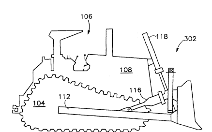
With reference to Fig. 1, an exemplary work
vehicle 102 is shown as a track type tractor (TTT).
However, the present invention may be adapted to other
types of earthmoving vehicles, e.g., scrapers, motor
graders, hydraulic excavators. In order to perform
real-time surveillance, the present invention may be
used with an earthmoving vehicle, as described below,
or a non-earthmoving vehicle, e.g., a pick-up truck.
The TTT 102 includes an undercarriage 104
which provides movement, an operator station 106, and
an engine 108. The TTT's work implement 110 includes
a push arm 112 on each side of the vehicle 102 (only
one is shown). A bulldozer blade 114 is rotatably
connected to the ends of the push arms 112. A pair of
tilt cylinders 116 provide movement of the blade 114
relative to the push arms 112. At least one lift
cylinder 118 provides movement of the blade 114
relative to the vehicle 102.
The blade's movement relative to the vehicle
are termed as pitch and tilt. Pitch refers to the
blade's front and back movement as shown in Fig. 1 and
labeled as G. As shown in Fig. 2 and labeled as F,
tilt refers to the blade's rotational movement. For
exemplary purposes only, the TTT 102 may have a
maximum tilt angle of 25- and a maximum pitch angle of
7.3-.
The TTT dimensions as labeled are:
A: length with blade straight
B: width
C: blade height
D: maximum digging depth
E: ground clearance at full lift
F: maximum tilt, and
G: maximum pitch.
WO 95/04gl7 PCT/US94/07442
--6--
~6~6~
In another embodiment, the apparatus 302 is
connected to a work vehicle 102 and is adapted to
determine the position of the work vehicle~s 102 work
implement 110 as it performs a fill or cut operation
or rests on the ground surface. With reference to
Fig. 4, the apparatus 302 is connected to the vehicle
102 on or near the work implement 110. The apparatus
302 is adapted to determine the terrestrial position
of a dynamic reference point behind the work
implement. The terrestrial position of the dynamic
reference point is used as an indication of the work
implement's position and/or topography of the site.
Referring to Figs. 3 and 5, the apparatus
302 includes a support member 304.
A means 306 determines the terrestrial
position of a terrestrial reference point 502 and
responsively produces a terrestrial position signal.
The terrestrial reference point position determining
means 306 is connected to the support member 304. In
the preferred embodiment, the terrestrial position
determining means 306 consists of a Global Positioning
System (GPS). A GPS 306 receives signals from a
constellation of man-made satellites orbiting the
earth and determines position relative to the Earth by
means of triangulation. Typically, a constellation
consists of 3-4 satellites. Preferably, the U.S.
Government's NAVSTAR GPS satellites are used. One
suitable GPS system is disclosed in U.S. Application
Serial Number 07/628,560 filed December 3, 1990 and
titled "Vehicle Position Determination System and
Method."
Returning to Fig. 3, the terrestrial
position determining means 306 includes a GPS antenna
308 and a GPS receiver 310. A suitable GPS antenna
308 is available from Magnavox Corp. of Torrance Ca as
WO95/04917 PCT~S94/07442
2 ~ q 3
--7--
model number 723010. In the preferred embodiment, the
antenna and pre-amp are mounted on the apparatus 302.
The GPS receiver is mounted elsewhere~on the vehicle.
The GPS receiver 310 is adapted to determine the
terrestrial position of the terrestrial reference
point which is typically located on the apparatus 302
or at the receiver 310.
A means 312 determines the location of the
dynamic reference point 506 relative to a local
reference point 504 located on the apparatus 302 and
responsively produces a local position signal. The
means 312 is connected to the support member 304.
In the preferred embodiment, the dynamic
reference point location determining means 312
includes an ultrasonic sensor 314. The ultrasonic
sensor 314 emits an ultrasonic wave aimed at the
dynamic reference point 506, receives a reflection of
the emitted wave and responsively determines the
distance between the ultrasonic sensor and the dynamic
reference point 506. The local reference point 504 is
located on the ultrasonic sensor 314 and is the point
from which the sensor measures the distance. One
suitable ultrasonic sensor 314 is available from Agtek
of Livermore, CA as model no. 9140.
In the preferred embodiment, the ultrasonic
sensor 314 includes a reference wire 316 to compensate
for temperature effects on the sensor's 314 accuracy.
The ultrasonic sensor 314 is adapted to determine the
distance to the ground and to calibrate its
measurements based on the measured and known distances
to the reference wire 316.
In the preferred embodiment, the dynamic
reference point location determining means 312
includes means 318 for determining the orientation of
the apparatus 302 with respect to the ground surface.
WO95/04gl7 PCT~S94/07442
2 ~6~ 3 -8-
In the preferred embodiment, the orientation of the
apparatus 302 is characterized in terms of pitch (~)
and tilt (~). If the apparatus 302 is connected to
the blade 114, as in Fig. 4, the pitch and tilt of the
apparatus 302 coincides with the pitch and tilt of the
blade 114 (see Figs. 1,2,4, and 5). The pitch and
tile of the apparatus 302 is used to determine the
location of an adjusted dynamic reference point 506'.
The terrestrial position of the dynamic reference
point is determined as a function of the measured tilt
and pitch (see below).
In the preferred embodiment, the orientation
determining means 318 includes a two dimensional
bubble sensor 320. With reference to Fig. 6, the two-
dimensional sensor 320 includes a casing 602 filled
with an electrically conductive fluid. A bubble or
pocket of gas 606, e.g., air, is trapped within the
casing 602. As the orientation of the apparatus 302
changes, the location of the bubble 606 moves within
the casing. The electrical impedance across thesensor 320 varies with the location of the bubble 606
and is proportional to the respective angles. The
sensor 320 measures the electrical impedance across
the casing on two perpendicular axes, as shown and
responsively determines the pitch and tilt angles. A
suitable 2-axis bubble sensor is available from
Spetron Glass and Electronics Inc of Hauppauge, NY as
model no. SP5000. In alternate embodiment, two single
axis sensors, model no. L-212t may be used.
Additionally, the present invention may alternately
use a pendulum type sensor.
With reference to Fig. 7, the apparatus 302
includes a controlling means 700. Preferably, the
controlling means 700 includes a microprocessor. In
wo 95/04917 ~ 2 7 3 PCT~S94/07442
the preferred embodiment, a notebook computer is used.
The controlling means 700 includes a means
- 702 for receiving the terrestrial position signal and
the local position signal, responsively determining
the terrestrial position of the dynam1c reference
point 506 and producing a dynamic reference point
terrestrial position signal.
In the preferred embodiment, the terrestrial
position of the dynamic reference point is determined
by the equations:
Xt = xt _ (hg + hS) sin
Yt = Yt -+ (hg + h5) sin ~
Zt = Zt ~ (hg + hS) (1 - sin2 ~ - sin2
15 ~) 1/2
where
Xt, Yt, Zt define the terrestrial position of the
dynamic reference point in Cartesian coordinates
xt, Yt, Zt define the terrestrial position of the
terrestrial reference point in Cartesian
coordinates;
h5 is the measured distance between the local
reference point and the dynamic reference point;
hg is the known distance between the terrestrial
reference point and the local reference point;
and
is the measured pitch angle; and
is the measured tilt angle.
A means 704 produces a desired reference
point position signal. In the preferred embodiment,
the desired reference point position signal producing
means 704 includes storage memory, e.g., random access
memory (RAM), erasable programmable read only memory
(EPROM), a fixed disk drive, a hard disk drive or
other suitable type of storage device. The storage
WO95/04917 PCT~S94/07442
10-
device retains the site plan including a series of
points on the site plane and their respective desired
terrestrial heights or positions. The desired
reference point position signal corresponds to the
desired height or position of the current dynamic
reference point according to the site plan.
A means 706 receives the desired reference
point position signal and the dynamic reference point
terrestrial position signal, compares the received
signals, and responsively producing a difference
signal. The difference signal corresponds to the
amount of material that has to be removed or filled in
order to meet the site plan specifications.
A storing means 708 receives signals and
stores the signals in a storage medium. The storing
means 708 may include any of the types of memory
listed above. The storing means 708 may be adapted to
download stored data to an external computer either
directly or through other means, e.g., a satellite
network. In one embodiment, the storing means 708
receives and stores the difference signal. In another
embodiment, the storing means 708 receives and stores
the dynamic reference point terrestrial position
signal.
A means 710 receives signal and displays the
information to the operator. In one embodiment, the
display means 710 receives the dynamic reference point
terrestrial position signal and responsively displays
dynamic reference point terrestrial position signal.
In another embodiment, the display means 710 receives
the difference signal and responsively displays the
difference signal. The display means 710 may display
the-received information in a number~of different
formats, e.g., a number, a graphic illustration
showing the information relative to~the site plane,
wo gs/04gl7 2 ~ ~ ~ 2 7 ~ PCT~S94/07442
and/or a graphic showing the difference. Other types
- of displays and/or formats are possible and the
present invention is not limited to any such type of
- display.
In an alternate embodiment, the information
may be relayed over a radio link to a remote location
for display and/or storage.
Industrial APPlicability
With reference to the drawings and in
operation the present invention or apparatus 302 is
adapted to determine the terrestrial position of a
dynamic reference point. As discussed above, the
dynamic reference point is preferably a point on the
ground surface and may be used to accomplish real-time
surveying of a site or may be used to determine the
position of a work vehicle's implement. The
terrestrial position of the dynamic reference point
506 is determined utilizing the apparatus 302
discussed above and the method described below.
First, the terrestrial position (Xt~yt~ Zt) of
a terrestrial reference point 502 is produced.
Preferably this is accomplished utilizing a global
position system (GPS). The GPS system includes a GPS
receiver 310 which receives electromagnetic signals
from orbiting satellites and determines the position
of a point on the receiver 310 (terrestrial reference
point 502) with respect to the Earth. "Terrestrial"
refers to a reference coordinate system. In one
embodiment, the terrestrial reference coordinate
system is centered at the Earth. The GPS receiver 310
determines positions relative to this coordinate
system. In another embodiment, the reference
coordinate system is fixed at the particular site. A
WO 95/04917 PCT/US94/07442
~6~7 3 -12-
simple transformation converts between the two
coordinate systems.
Second, the location (Xml Yml Zm) of the
dynamic reference point (506) relative to a local
reference point (504) located on the apparatus (302)
is determined and a local position signal is
responsively produced. In the preferred embodiment,
this step entails using an ultrasonic sensor 314 for
determining the distance (hS) between a local reference
point 504 located on the apparatus 302 and the dynamic
reference point and an orientation sensor 320 for
determining the tilt and pitch of the apparatus 302.
The local position signal is preferably indicative of
the determined distance, hS.
The terrestrial position (Xt~yt~ Zt) Of the
dynamic reference point is determined as a function of
the terrestrial position of the terrestrial reference
point, the distance between the local reference point
and the dynamic reference point and the orientation of
the apparatus 302 (see discussion above).
The terrestrial position of the dynamic
reference point maybe used as an indicator of tool
position or may be used as an indicator of the
topography of the work site.
In one embodiment, the apparatus 302 is
mounted on a vehicle, e.g., a pickup or a bulldozer.
The topography of the work site may be obtained by
driving over the work site. If done with the
bulldozer, this is accomplished with the blade in a
raised position.
Other aspects, objects, and features of the
present invention can be obtained from a study of the
drawings, the disclosure, and the appended claims.