Language selection

Search

Patent 2172546 Summary

Third-party information liability

Some of the information on this Web page has been provided by external sources. The Government of Canada is not responsible for the accuracy, reliability or currency of the information supplied by external sources. Users wishing to rely upon this information should consult directly with the source of the information. Content provided by external sources is not subject to official languages, privacy and accessibility requirements.

Claims and Abstract availability

Any discrepancies in the text and image of the Claims and Abstract are due to differing posting times. Text of the Claims and Abstract are posted:

  • At the time the application is open to public inspection;
  • At the time of issue of the patent (grant).
(12) Patent Application: (11) CA 2172546
(54) English Title: NAVIGATION SYSTEM USING RE-TRANSMITTED GPS
(54) French Title: SYSTEME DE NAVIGATION UTILISANT UN SIGNAL GPS RETRANSMIS
Status: Dead
Bibliographic Data
(51) International Patent Classification (IPC):
  • G01S 5/14 (2006.01)
  • G01S 5/00 (2006.01)
  • G01S 5/10 (2006.01)
  • H04B 7/195 (2006.01)
(72) Inventors :
  • AGUADO, MORTON M. (United States of America)
(73) Owners :
  • GRUMMAN AEROSPACE CORPORATION (United States of America)
(71) Applicants :
(74) Agent: RIDOUT & MAYBEE LLP
(74) Associate agent:
(45) Issued:
(86) PCT Filing Date: 1994-09-08
(87) Open to Public Inspection: 1995-03-30
Examination requested: 2001-08-15
Availability of licence: N/A
(25) Language of filing: English

Patent Cooperation Treaty (PCT): Yes
(86) PCT Filing Number: PCT/US1994/009536
(87) International Publication Number: WO1995/008778
(85) National Entry: 1996-03-22

(30) Application Priority Data:
Application No. Country/Territory Date
127,039 United States of America 1993-09-24

Abstracts

English Abstract


A system for measuring the relative positions of first and second units (1, 2) includes a re-transmitting apparatus at the first unit (1)
and a receiver at the second unit (2) capable of making simultaneous real-time comparisons of phase and frequency information contained in
first signals received directly from the satellites (3, 3', 3'', 3''') by the second unit (2) and second signals received from the satellites (3, 3',
3'', 3''') by the first unit (1) and immediately re-transmitted to the second unit (2) in their entirety without processing before transmission.


French Abstract

Système servant à mesurer les positions relatives d'une première et d'une deuxième unité (1, 2) et comprenant un dispositif de retransmission au niveau de la première unité (1) et un récepteur au niveau de la deuxième unité (2) pouvant effectuer des comparaisons simultanées en temps réel d'informations de phase et de fréquence contenues dans des premiers signaux reçus directement des satellites (3, 3', 3'', 3''') par la deuxième unité (2) et dans des deuxièmes signaux reçus des satellites (3, 3', 3'', 3''') par la première unité (1) et retransmis immédiatement à la deuxième (2) dans leur intégralité sans traitement avant retransmission.

Claims

Note: Claims are shown in the official language in which they were submitted.


21
Claims:


1. In a system for determining positions of a first unit
relative to a second unit of the type which includes means
for receiving signals from a plurality of satellites
deployed at spaced intervals within one or more
geostationary orbits, said satellites transmitting GPS
signals to first and second units whose relative positions
are to be determined, the improvement comprising means at
the first unit for retransmitting the signals in their
entirety, without delay, from said satellites to the second
unit; means at the second unit for receiving signals
directly from said satellites and for simultaneously
receiving the signals retransmitted from the first unit;
signal processing means connected to said receiving means
for performing a sample-by-sample comparison of the directly
received and retransmitted signals in order to extract
information, without input of additional position data,
concerning the relative positions of the first and second
units.


2. A system as claimed in claim 1, wherein said signal
processing means comprises means for computing a first set
of range measurements based on said retransmitted signals,
means for computing a second set of range measurements based
on the GPS signals received from said satellites, and means
for subtracting said respective range measurements in said


22

first and second sets to obtain a difference measurement
free of bias errors.

3. A system as claimed in claim 2, wherein said signal
processing means further comprises means for calculating a
set of double difference range measurements based on said
first and said second sets of range measurements, and
deriving the position of said first unit relative to said
second unit based on said double difference range
measurements.

4. A system as claimed in claim 3, wherein the double
difference range equations are derived from the following
equations:
.delta..DELTA.R12 = (R2'' - R2') (R1''- R1')
.delta..DELTA.R13 = (R3'' - R3') - (R1''- R1')
.delta..DELTA.R14 = (R4'' - R4') - (R1''- R1')
where R'i and R"i (i = 1 to 4) are respective first and second
pseudo-range measurements.

5. A system as claimed in claim 2, wherein said signal
processing means further comprises means for calculating a
set of double difference range measurements based on said
first and said second sets of range measurements;
means for computing a set of GPS carrier phase
measurements representing cumulative measurements of the
carrier phase to each of said satellites; and means for
calculating a set of double difference accumulated carrier

23

phase measurements based on said set of GPS carrier phase
measurements, the position of said first relative unit
relative to said second unit being derived based on said
double difference range measurements and said double
difference accumulated carrier phase measurements.


6. A system as claimed in claim 5, wherein the double
difference range equations are derived from the following
equations:

.delta..DELTA.R12 = (R2'' - R2') - (R1''- R1')
.delta..DELTA.R13 = (R3'' - R3') - (R1''- R1')
.delta..DELTA.R14 = (R4'' - R4') - (R1''- R1')
where R'i and R"i (i = 1 to 4) are respective first and
second pseudo-range measurements.


7. A system as claimed in claim 6, wherein said set of
double difference accumulated carrier phase measurements are
related to said set of double difference range measurements
by the following equations:

?.PHI.12 = [(R2" - R2') - (R1" - R1')] / 2 - N12
?.PHI.13 = [(R3" - R3') - (R1" - R1')] / 2 - N13
?.PHI.14 = [(R4" - R4') - (R1" - R1')] / 2 - N14

where ?.PHI.12, ?.PHI.13, ?.PHI.14 are the double difference accumulated
carrier phases for satellites 1 to 4, and N12, N13, N14 are the
initial integer phase ambiguities for satellites 1 to 4.


24
8. A system as recited in claim 1, wherein said plurality
of satellites comprises four satellites.


9. A system as recited in claim 1, wherein said receiving
means is a single receiver having a number of channels equal
to at least twice the number of said satellites, a first
half of said channels being dedicated to receiving the
signals from said satellites and a second half of said
channels being dedicated to receiving the signals re-
transmitted from the first unit.


10. A system as recited in claim 1, wherein said receiving
means includes a first receiver for receiving the signals
from said satellites and a second receiver for receiving the
signals re-transmitted from the first unit.


11. A system as recited in claim 1, wherein said receiving
means includes a receiver for receiving the signals from
said satellites and an interferometer for receiving and
extracting phase information from the signals re-transmitted
from the first unit.


12. A system as recited in claim 1, wherein the re-
transmitting means at said first unit includes a receiving

antenna for receiving signals from said satellites, an
amplifier for amplifying the signals from the receiving
antenna, and a transmitter for transmitting the signals in
their amplified state to the second unit.


13. A navigation system for use in conjunction with a
global positioning system, comprising:
a first user station having GPS signal re-
transmitting means; and
a second user station having a receiving means for
receiving simultaneously a first series of GPS signals from
a predetermined number of satellites along a signal path
extending directly between said satellites and said second
user station and a second series of GPS signals from the
same satellites along a signal path which passes through the
re-transmitting means at said first user station, and
a computing means for computing a first set of
range measurements based on said first series of GPS
signals, computing a second set of range measurements based
on second series of GPS signals, computing a set of
differential range measurements by subtracting respectively
said first set of range measurements from said second set of
range measurements, computing a set of double difference
range measurements by subtracting said differential range
measurements from one another, and deriving from said set of
double difference range measurements a position of the first
user station relative to said second user station.


14. A system as claimed in claim 13, wherein the
double difference range measurements for the respective
are obtained from the following equations:
.delta..DELTA.R12 = (R2'' - R2') - (R1''- R1')
.delta..DELTA.R13 = (R3'' - R3') - (R1''- R1')

26

.delta..DELTA.R14 = (R4'' - R4') - (R1''- R1')
where R'i and R"i (i = 1 to 4) are respective first and
second pseudo-range measurements.


15. A system as claimed in claim 14, wherein said computing
means computes a set of GPS carrier phase measurements
representing cumulative measurements of the carrier phase to
each of said satellites and then computes a set of double
difference accumulated carrier phase measurements based on
said set of GPS carrier phase measurements, the relationship
between said set of double difference accumulated carrier
phase measurements and said set of double difference range
measurements being given by the following equations:
?.PHI.12 = [(R2" - R2') - (R1" - R1')] / 2 - N12
?.PHI.13 = [(R3" - R3') - (R1" - R1')] / 2 - N13
?.PHI.14 = [(R4" - R4') - (R1" - R1')] / 2 - N14
where ?.PHI.12, ?.PHI.13, ?.PHI.14 are the double difference accumulated
carrier phases for satellites 1 to 4, and N12, N13, N14 are the
initial integer phase ambiguities for satellites 1 to 4, the
position of the first user station relative to the second
user station also being derived from said set of double
difference accumulated carrier phase measurements.


16. A navigation system as recited in claim 13, wherein
said predetermined number of satellites is four.


27

17. A navigation system as recited in claim 13, wherein
said receiving means is a single GPS receiver having a
number of channels equal to at least twice the number of
said satellites, a first half of said channels being
dedicated to receiving said first series of GPS signals and
a second half of said channels being dedicated to receiving
said second series of GPS signals.

18. A navigation system as recited in claim 13, wherein
said receiving means includes first and second GPS
receivers, said first GPS receiver receiving said first
series of GPS signals and said second GPS receiver receiving
said second series of GPS signals.

19. A navigation system as recited in claim 13, wherein
said receiving means includes a GPS receiver for receiving
said first series of GPS signals and an interferometer for
receiving and combining said second series of GPS signals.

20. A navigation system as recited in claim 13, wherein the
re-transmitting means at said first user station includes a
receiving antenna for receiving GPS signals from said
satellites, an amplifier for amplifying the GPS signals from
the receiving antenna, and a transmitter for transmitting
the GPS signals in their amplified state to the second user
station.

28

21. In a system for determining velocities of a first
unit relative to a second unit of the type which includes
means for receiving signals from a plurality of satellites
deployed at spaced intervals within one or more
geostationary orbits, said satellites transmitting GPS
signals to first and second units whose relative velocities
are to be determined, the improvement comprising means at
the first unit for retransmitting the signals in their
entirety, without delay, from said satellites to the second
unit; means at the second unit for receiving signals
directly from said satellites and for simultaneously
receiving the signals retransmitted from the first unit;
signal processing means connected to said receiving means
for performing a sample-by-sample comparison of the directly
received and retransmitted signals in order to extract
information, without input of additional position data,
concerning the relative velocities of the first and second
units.


22. A system as claimed in claim 21, wherein said signal
processing means comprises means for computing a first set
of velocity measurements based on said retransmitted
signals, means for computing a second set of velocity
measurements based on the GPS signals received from said
satellites, and means for subtracting said respective
velocity measurements in said first and second sets to
obtain a difference measurement free of bias errors.


29

23. A system as claimed in claim 21, wherein said
signal processing means further comprises means for
calculating a set of double difference velocity measurements
based on said first and said second sets of velocity
measurements, and deriving the velocity of said first unit
relative to said second unit based on said double difference
velocity measurements.

24. The system as claimed in claim 21, wherein said signal
processing means further comprises means for calculating a
set of double difference velocity measurements based on said
first and said second sets of velocity measurements, means
for computing a set of GPS carrier phase measurements
representing cumulative measurements of the carrier to each
of said satellites; and means for calculating a set of
double difference accumulated carrier phase measurements,
the position of said first unit relative to said second unit
being derived from said double difference velocity
measurements and said double difference accumulated carrier
phase measurements.

25. In a method of determining positions of a first unit
relative to a second unit of the type which includes the
step of receiving signals from a plurality of satellites
deployed at spaced intervals within one or more
geostationary orbits, the improvement comprising the steps
of retransmitting the signals in their entirety, without
delay, from said satellites to the second unit; receiving at


the second unit directly from said satellites and
simultaneously receiving the signals retransmitted from the
first unit; and performing a real time sample-by-sample
comparison of the directly received and retransmitted
signals in order to extract information, without input of
additional position data, concerning the relative positions
of the first and second units.


26. A method as claimed in claim 25, further comprising the
steps of computing a first set of range measurements based
on said retransmitted signals, means for computing a second
set of range measurements based on the GPS signals received
from said satellites, and means for subtracting said
respective range measurements in said first and second sets
to obtain a difference measurement free of bias errors.


27. A method as claimed in claim 26, further comprising the
steps of calculating a set of double difference range
measurements based on said first and said second sets of
range measurements, and deriving the position of said first
unit relative to said second unit based on said double
difference range measurements.


28. A method as claimed in claim 27, wherein the step of
calculating the set of double difference range measurements
comprises the step of computing .delta..DELTA.Rnx, .delta..DELTA.Rny, and .delta..DELTA.Rnz defined

as follows:
.delta..DELTA.R12 = (R2'' - R2') - (R1''- R1')

31

.delta..DELTA.R13 = (R3'' - R3') - (R1''- R1')
.delta..DELTA.R14 = (R4'' - R4') - (R1''- R1')
where R'i and R"i (i = 1 to 4) are respective first and second
pseudo-range measurements.


29. A method as claimed in claim 26, further comprising the
steps of: calculating a set of double difference range
measurements based on said first and said second sets of
range measurements; computing a set of GPS carrier phase
measurements representing cumulative measurements of the
carrier phase to each of said satellites, calculating a set
of double difference accumulated carrier phase measurements
based on said set of GPS carrier phase measurements; and
deriving the position of said first unit relative to said
second unit based on said double difference range
measurements and said double difference accumulated carrier
phase measurements.


30. A method as claimed in claim 29, wherein said double
difference range equations are given by:
.delta..DELTA.R12 = (R2'' - R2') - (R1''- R1')
.delta..DELTA.R13 = (R3'' - R3') - (R1''- R1')
.delta..DELTA.R14 = (R4'' - R4') - (R1''- R1')
where R'i and R"i (i - 1 to 4) are respective first and second
pseudo-range measurements.


31. A method as claimed in claim 30, wherein said set of
double difference accumulated carrier phase measurements are


32

related to said double difference range measurements
according to the following equations:
?.PHI.12 = [(R2" - R2') - (R1" - R1')] / 2 - N12
?.PHI.13 = [(R3" - R3') - (R1" - R1')] / 2 - N13
?.PHI.14 = [(R4" - R4') - (R1" - R1')] / 2 - N14
where ?.PHI.12, ?.PHI.13, ?.PHI.14 are the double difference accumulated
carrier phases for satellites 1 to 4, and N12, N13, N14 are the
initial integer phase ambiguities for satellites 1 to 4.

32. A method as claimed in claim 26, wherein the step of
receiving signals from a plurality of satellites comprises
the steps of receiving said signals from four satellites and
processing said signals separately using a common clock to
extract phase information indicative of ranges from the
respective signals.

33. A method as claimed in claim 27, wherein said step of
performing a comparison comprises the step of extracting a
phase difference by comparing a satellite-generated code in
the directly received signal with a satellite-generated code
in the retransmitted signal.

34. A method as claimed in claim 27, wherein the step of
retransmission comprises the step of shifting the
retransmitted signals to an L-band carrier different from
the direct signal carrier, or by shifting the retransmitted
signals to other, unused GPS codes, to avoid overlap.

33

35. A method for calculating a position of a first unit
relative to a second unit, comprising the steps of:
receiving at the second unit a first series of GPS
signals from a predetermined number of satellites, said
first series of GPS signals traversing signal paths
extending directly between said satellites and said second
point of interest;
receiving at the second unit a second series of
GPS signals from the same satellites, said second series of
GPS signals traversing signals paths which pass through a
re-transmitting means located at the first point of
interest;
computing a first set of range measurements based
on the first series of GPS signals;
computing a second set of range measurements based
on the second series of GPS signals;
computing a set of differential range measurements
by subtracting respectively said first set of range
measurements from said second set of range measurements;
computing a set of double difference range
measurements by subtracting said differential range
measurements from one another; and
deriving from said set of double difference range
measurements a position of the first user station relative
to said second user station.


34

36. A method as claimed in claim 35, wherein the step of
computing double difference range equations comprises the
step of computing .delta..DELTA.Rnx, .delta..DELTA.Rny, and .delta..DELTA.Rnz defined as follows:
.delta..DELTA.R12 = (R2'' - R2') - (R1''- R1')
.delta..DELTA.R13 = (R3'' - R3') - (R1''- R1')
.delta..DELTA.R14 = (R4'' - R4') - (R1''- R1')

where R'i and R"i (i = 1 to 4) are respective first and
second pseudo-range measurements.

37. A method as claimed in claim 35, wherein said set of
double difference accumulated carrier phase measurements are
related to said double difference range measurements
according to the following equations:
?.PHI.12 = [(R2" - R2') - (R1" - R1')] / 2 - N12
?.PHI.13 = [(R3" - R3') - (R1" - R1')] / 2 - N13
?.PHI.14 = [(R4 - R4') - (R1" - R1')] / 2 - N14
where ?.PHI.12, ?.PHI.13, ?.PHI.14 are the double difference accumulated
carrier phases for satellites 1 to 4, and N12, N13, N14 are the
initial integer phase ambiguities for satellites 1 to 4.

38. A method as claimed in claim 37, further comprising the
steps of: computing a set of GPS carrier phase measurements
representing cumulative measurements of the carrier phase to
each of said satellites; and calculating a set of double
difference accumulated carrier phase measurements based on
said set of GPS carrier phase measurements, said set of
double difference accumulated carrier phase measurements


being related to said double difference range measurements
according to the following equations:
?.PHI.12 = [(R2" - R2') - (R1" - R1')] / 2 - N12
?.PHI.13 = [(R3" - R3') - (R1" - R1')] / 2 - N13
?.PHI.14 = [(R4" - R4') - (R1" - R1')] / 2 - N14
where ?.PHI.12, ?.PHI.13, ?.PHI.14 are the double difference accumulated
carrier phases for satellites 1 to 4, and N12, N13, N14 are the
initial integer phase ambiguities for satellites 1 to 4, the
position of the first user station relative to the second
user station also being derived from the double difference
accumulated carrier phase measurements.


39. A method as claimed in claim 35, wherein the step of
receiving signals from a plurality of satellites comprises
the steps of receiving said signals from four satellites and
processing said signals separately using a common clock to
extract phase information indicative of ranges from the
respective signals.


40. A method as claimed in claim 35, wherein said step of
performing a comparison comprises the step of extracting a
phase difference by comparing a satellite-generated code in
the directly received signal with a satellite-generated code
in the retransmitted signal.


41. A method as claimed in claim 35, wherein the step of
retransmission comprises the step of shifting the


36

retransmitted signals to an L-band carrier different from
the direct signal carrier, or by shifting the retransmitted
signals to other, unused, GPS codes, to avoid overlap.


42. In a method of determining velocities of a first unit
relative to a second unit of the type which includes the
step of receiving signals from a plurality of satellites
deployed at spaced intervals within one or more
geostationary orbits, the improvement comprising the steps
of retransmitting the signals in their entirety, without
delay, from said satellites to the second unit; receiving at
the second unit directly from said satellites and
simultaneously receiving the signals retransmitted from the
first unit; and performing a real time sample-by-sample
comparison of the directly received and retransmitted
signals in order to extract information, without input of
additional velocity data, concerning the relative velocities
of the first and second units.


43. A method as claimed in claim 25, further comprising the
steps of computing a first set of velocity measurements
based on said retransmitted signals, means for computing a
second set of velocity measurements based on the GPS signals
received from said satellites, and means for subtracting
said respective velocity measurements in said first and
second sets to obtain a difference measurement free of bias
errors.


37

44. A method as claimed in claim 26, further comprising the
steps of calculating a set of double difference velocity
measurements based on said first and said second sets of
velocity measurements, and deriving the velocity of said
first unit relative to said second unit based on said double
difference velocity measurements.


45. A method as claimed in claim 26, further comprising the
steps of calculating a set of double difference velocity
measurements based on said first and said second sets of
velocity measurements, computing a set of GPS carrier phase
measurements representing cumulative measurements of the
carrier phase to each of said satellites, calculating a set
of double difference accumulated carrier phase measurements
based on said set of GPS carrier phase measurements, and
deriving the velocity of said first unit relative to said
second unit based on said double difference velocity
measurements and said double difference accumulated carrier
phase measurements.


Description

Note: Descriptions are shown in the official language in which they were submitted.


~VO 95/08778 ~ ... r- -: 2 1 7 2 5 4 6 PCT/USg4/09536
., ! t


Navigation System u~ing Re-Tr~nsmitted GPS

BACKGROUND OF THE I~V~N'110N

1. Field of the Invention
This invention generally relates to a navigation system
which uses satellites to compute position and velocity data
for guiding or tracking a variety of airborne, marine, and
land-based systems.

2. DescriPtion of Related Art
The accuracy of position-determining systems for
airborne, marine, and land-based systems has been greatly
increased with the advent of satellite ~chnslogy, and in
particular the Navigation Satellite Timing and Ranging
Global Positioning System (NAVSTAR GPS). In this system, a
total of 24 satellites are deployed, with four satellites in
each of six orbit planes, so that at least four satellites

W095/08778 / ;~- - 2 ~ 72546 PCT~Ss~/09536

come within the same field of view twenty-four hours a day
all over the world.

The general approach to utilizing GPS for navigation
purposes, known as absolute GPS, is simply to calculate the
range to the satellites in view by measuring the
transmission and receiving time in comparison with a clock
synchronized to the satellite clock given the position of
the satellite at the transmitting time. The accuracy of
this approach is approximately 15 meters spherical error
probable (SEP). In many applications, such as position and
velocity determination for the purpose of assisting
precision approaches during landing of aircraft, an accuracy
of 15 meters is insufficient.

In an attempt to improve the accuracy of GPS in
general, a t~chnique known as differential GPS has been
~ ed to eliminate those errors which are common to both
a user and the reference receivers. Differential GPS uses
a GPS receiver at a fixed surveyed site to compute fixed
bias corrections for the GPS satellite range measurements
based on the difference between the position calculated
using the reference receiver's GPS measurements and that
defined by the site survey. These bias correction
measurements are then commllnicated via a data link to a
vehicle whose position and/or velocity is to be determ~

W095/08778 ~~' " 2 l 7 2 5 4 6 PCT~S91/09~36
_ 3


While for many applications differential GPS navigation
represents an improvement over absolute GPS, it too has a
number of drawbacks. The need for a fixed survey site and
a communication link between the site and the subject
vehicle, as well as the latency and degradation of the
corrections with time, all limit the ability of differential
GPS to provide the very accurate position data reguired for
precision applications such as approach and l~n~in~
navigation requirements at airports.


A variation of the differential GPS teçhnique, in which
the GPS signal received at the subject vehicle is
retransmitted to the base site for comparison, has been
proposed in U.S. Patent No. 5,119,102. While similar to the
present invention in its use of retransmission, the
designers of this system have apparently failed to
appreciate the possibility of real-time comr~rison of
simultaneously received direct and retransmitted GPS
signals.


The core of their approach, receipt of the GPS signals,
time tagging with "Time of Arrival," ~e~oL~ing of the GPS
data, and subsequent transmission of the data at a slower
rate via a radio channel, are all llnn~c~s~ry and wasteful.
In contrast, this invention dispenses with all these

elements and provides a completely different approach to re-

transmission which will provide for substantially greaterefficiency and error reduction.


W095/08778 ~ 2 ~ 7 2 5 4 6 PCT~S94/09536 ~

The need for accurate navigation data is especially
acute in the case of automatic carrier landings, where the
runway is excee~;ngly short and narrow and extremely
unforgiving. The slightest miscalculation in the navigation
of the aircraft relative to the carrier runway could result
in disaster. Present systems, including absolute and
differential GPS, and the system disclosed in U.S. Patent
No. 5,119,102, are incapable of meeting the accuracy
requirements for such carrier landings.

SU~ARY OF THE I~V~N'1'10N
It is a first objective of the invention to provide a
satellite-based navigation system, and in particular a GPS
navigation system, which does not have the errors associated
with data generated by conventional absolute and
differential GPS navigation systems, resulting in the
generation of position and velocity measurements having
increased accuracy.

It is a second objective of the invention to provide a
satellite-based navigation system, and in particular a GPS
naYigation system, in which all n~ces-cAry calculations are
made at one user station using a single receiver, as opposed
to conventional absolute and differential GPS systems which
take range measurements to at least two user stations using
two different receivers, thereby eliminating receiver error
attributable to the use of two receivers and clock errors
attributable to the use of multiple GPS receiver clocks.

W095/08778 "~'t;~ , 2 1 72546 PCT~S94/09536
~ 5


It is a third objective of the present invention to
provide a satellite-based navigation system which is less
expensive to implement because it requires less hardware
than certain conventional satellite-based systems--only one
receiver as opposed to two, and because there is no need for
additional data or communications links between the receiver
and a surveyed site.


It is a fourth objective of the present invention to
provide a navigation system which uses satellites to compute
position information which can fulfill the navigation
accuracy requirements for precision approach and landing of
aircraft at airports or for automatic carrier landing.


These objectives are achieved by recasting the
navigation problem as a relative one where the GPS position
and velocity of one unit (e.g., an aircraft or landing
point) is computed relative to the other unit (landing point
or aircraft), and by maximizing the commonality of
equipment, satellites, and propagation path (for units in
the same proximity) into a single receiver on a measurement-

to-measurement basis, thus utilizing the full relative
navigation potential for error reduction and eliminating the
need to compute and communicate data between the two units

beyond the re-transmitted GPS signal.


The basic idea in this re-transmitted GPS approach is
to re-transmit the GPS data received from a set of

W095/08778 ; `` ~ 2 1 7 25 4 6 PCT~S94tO953

satellites at the antenna of one unit directly, as received,
to the second unit where the first and second units'
relative position and/or velocity are computed using data
derived from the same set of satellites. The re-
transmitting unit therefore acts only as a GPS signal pass-
through and no measurements need be made the first unit.

In a preferred Pmho~i~ent of the invention, the re-
transmitted data is processed by the second unit's GPS
receiver/computer, which effects a pseudo-range and a
pseudo-range rate measurement, from which it cu,..~Les the
first unit's position and velocity based on the re-
transmitted GPS data, and its own position and velocity
based on GPS data it receives directly. Since unit 2 makes
all the measurements simultaneously, it can choose
measurements to the same satellites to make the computation.
Effectively, the relative position and velocity computation
will be based on simultaneous measurements, taken to the
same satellites via two paths and processed in a common
receiver. Thus, errors common to both units c~ncel,
resulting in substantial error reduction on a sample-to-
sample ~asis.

Because the GPS landing data has been recast in
relative terms of one unit relative to another unit, the
absolute position of either unit is of no consequence, and
the need for a surveyed site is precluded unless a
particular application requires it.

2 1 72546
wo9slo8778 `, ~ PCT~S9~/09536

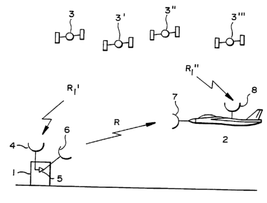
BRIEF DESCRIPTION OF THE DRAWINGS
Figure 1 is a schematic diagram showing a first
preferred embodiment of the navigation system of the present
invention wherein GPS signals are retransmitted from an
- 5 airport to an aircraft to allow the aircraft to compute its
position and velocity relative to the airport;

Figure 2 is a schematic diagram showing pseudo-ranges
computed by the navigation system of the present invention;
and

Figure 3 is a schematic diagram showing a second
preferred embodiment of the navigation system of the present
invention wherein GPS signals are retransmitted from an
aircraft to a carrier ship to allow the carrier ship to
compute the aircraft's position and velocity relative to the
ship.

Figure 4 is a schematic diagram showing a third
preferred embodiment of the navigation system of the present
invention wherein GPS signals are compared and more accurate
vertical data is derived using an interferometer.

DE~TT.~n DESCRIPTION OF THE PREFERRED EMBODlLI~NlS
Figure 1 is a schematic diagram of a satellite
navigation system arranged to determine the position of a
first unit 1 relative to a second unit 2, in which the first
unit is carried by an aircraft and the second unit is

~ogsl08778 2 1 7 2 5 4 6 PCT~Sg4/09536 ~

located at an airport, the relative positioning information
being used to assist the aircraft in making a precision
~ ng at the airport. It will of course be appreciated by
those skilled in the art that the system may be used in a
variety of contexts where precision navigation is required,
including land and marine vehicles, as well as both manned
and lln~nne~ airborne vehicles.

As shown in Fig. 1, the navigation system includes a
re-transmitting unit 1, a receiving unit 2, and four
lo satellites 3, 3', 3'', and 3''' in the field of view of the
first and second units. Additional satellites may also be
in view. Sa~ellites 3 are NAVSTAR GPS satellites deployed
at spaced intervals in predefined geostationary orbits,
although it is possible that other satellite systems may be
deployed in the r~L~Le to which the principles of the
invention could also be applied. Once such system could be
the Soviet Satellite Navigation System GLONASS which is
presently being deployed.

Each satellite 3'-3''' transmits a GPS range-finding
signal to all points within its field of view. By measuring
the propagation time of these signals, a user within this
field of view can determine the distance or range to the
respective satellites. ~heoretically, only three satellites
are required to calculate a three-dimensional position, but
the use of four satellites enables a fourth variable, the
GPS time correction factor TB, to be utilized to compensate

W095/08778 ;~ 2 1 7 2 5 4 6 PCT~S94/09536

for used satellite clock synchronization. If only two-
dimensional positions such as latitude and longitude are
required, three satellites are sufficient. A number of
satellites greater than four would provide further accuracy.

.


In the embodiment of Figure 1, re-transmitting unit 1
operates solely as a signal pass-through, sending the GPS
signals it detects from satellites 3 to receiving unit 2 in
their entirety for simultaneous processing with GPS signals
received by the receiving unit 2 directly from the
re pective satellites. Re-transmitting unit 1 neither
processes the GPS signals in any way nor performs range
measurements of any type. As a result, the hardware
required for unit 1 is very simple: a receiving antenna 4
for detecting the GPS signals transmitted from satellites
3-3''', an amplifier circuit 5 for amplifying the GPS
signals, and a transmitter 6 for re-transmitting the
amplified GPS signals to receiving unit 2. Those skilled in
the art will appreciate that an absolute range measurement
could be made at unit 1 by attaching a signal splitter (not
shown) at antenna 4 to redirect a portion of the detected
GPS signals into a GPS receiver/~u~Ler (not shown), which

in turn would compute the absolute position of unit 1 in GPS
coordinates, but such an addition to the retransmitting
arrangement would have no effect on the determination of
unit l's position relative to unit, by unit 2.

W095/08778 ~ C~ 2 1 7 2 5 4 6 PCT~Sg4/09536 ~


Unit 1 could also utilize the data block in the GPS
signal which is reserved for special messages by inserting
information such as an identification code into the GPS
signal during amplification.


Receiving unit 2 includes two multi-ch~nnp~ GPS
receivers connected to antPnn~ 7 and 8 for receiving
respectively the GPS signals re-transmitted from unit 1
(hereinafter called the "re-transmitted GPS signals") and
the GPS signals transmitted to unit 2 directly from
satellites 3 (hereinafter called the "direct GPS signals").
Each GPS receiver preferably includes at least four rhAn~els
for respectively receiving a GPS signal from each of the
four satellites 3-3'''. Means, however, must be provided
for synchronizing the clocks of the two receivers 50 tha~
~he time bias is the same for the measurements in both
receivers. This synchronization can be done in hardware or
in software by computing the TB or both receivers. The two
GPS receivers, however, may be replaced by a single GPS
receiver having at least eight channels, four of which would
be dedicated to receiving the direct GPS signals and four of
which would be dedicated to receiving the re-transmitted GPS
signals, and since all the channels use the same clock,
would not require the TB synchronization alluded to above.


Receiving unit 2 includes a signal processing unit

which processes the re-transmittal and direct signals
received by respective antennas 7 and 8 to derive the

WO9~t08778 ~; ",~ 7 2 5 4 6 PCT~S94/09536


11
position of receiving unit 2 relative to re-transmitting
unit 1 in three dimensional coordinates, as illustrated in
Figure 2. This process essentially involves deriving a set
of double difference pseudo-range measurements based on the
direct and re-transmitted GPS signals, and since all the
çh~n~els would use the same clock, would not require the TB
synchronization alluded to above.


The range R," between each of the four satellites and
receiving unit 2 along signal paths which extend directly
between each of the satellites and unit 2 is given by the
following relationship:


~ ~ R;'' + TB (1)


where i = 1 to 4 for four satellites, R;'' is the pc~ O
ranges from the respective satellites to unit 2, and TB is

the GPS time bias represented in units of range, which is
the same fixed constant for each satellite. A pseudo-range
measurement is one representing the range between the point
of tr~nc~iccion and the point of reception without regard to
the distance error, represented by the time bias constant.
In the equations above, Ri~ is the pseudo range, while Ri''
+ TB, for example, is the true range, i.e., the distance
between the point of transmission and the point of reception
- with the distance error factored in.

Woss/08778 .;~ 2 ~ 7 2 5 4 6 PCT~Ss4/09536

Similarly, the range ~r between each of the four
satellites and receiving unit 2 through a signal path which
passes through re-transmitting unit 1 is represented by the
relationship:

~ + TB + R (2)

where i = 1 to 4 in the case of four satellites, ~' is the
pseudo-range between each of the satellites and unit 2, TB
is again the GPS time bias for each of the satellites, and
R is the range ~etween re-transmitting unit 1 and receiving
unit 2.

This set of range equations is first combined by
subtracting respective equations in the set of true range
equations corresponding to the re-transmitted signal path
from equations in the set of true range equations
corresponding to the direct signal path, as follows:

~ Rjd Rj~ = Rj''-- R~'--R (3)

Difference equation ( 3 ) eliminates the time bias term
as an unknown in the equations and is made possible by the
use of the same four satellites for both units and the fact
that the same clock, that of receiver 2, can be used for
both pseudo-range calculations. Since the position of
receiving unit 2 relative to re-transmitting unit 1 can be
derived from the pseudo-range calculations R;' ' - ~', only

~ W095/08778 . 2 1 72 5 4 6 PCT~S94/oss36

13
one unknown R is left in the equation, and all bias-like
errors such as satellite clock ephmeris, propagation,
receiver, and others common to units 1 and 2 are eliminated
on a sample-to-sample basis. At this point, only the re-
5 transmission errors associated with R, the range between
unit 1 and unit 2.

To eliminate the range and the re-transmission errors,
including re-tr~s~i~cion multipath errors, the resulting
set of difference equations is then combined to obtain a set
of double difference range equations, derived by taking the
difference between pairs of first difference range
equations. The double difference taken produces three
equations given by:

. ~RI2 = tRz~ ~ R2 ) (R~ Rl') (4)
~RI3 = (R3'' - R3') - (R~''- Rl') (5)
8~RI4 = (R4'' - R4') - (Rl''- Rl') (6)

The quantities ~RI2~ ~RI3, and ~ARI4 represent the
double difference pseudo-range measurements from which the
three-dimensional position of unit 2 relative to unit 1 can
be determined.

In practice, the GPS signals received from satellites
- 3 by receiving unit 2 could be converted into pseudo-range
measurements R;' and R;'' in the conventional manner by
multiplying the speed of light by the difference between the

~` f ':
W095l08778 ~jf~ ; . PCT~S9~/09536
14 2 ~ 7254~ ~
transmission time and the arrival time of the GPS signals,
the time difference being obtained by measuring the phase
shift necessary to line up the satellite generated code in
a respective GPS signal with a correspon~ing receiver
generated code. However, even further error reduction can
be obtained with the double difference techn;que by lining
up the satellite-generated re-transmitted signal code with
the satellite generated directly received signal code in a
receiver designed for this type of measurement.


Those skilled in the art will appreciate that relative
velocity data free from bias and multipath errors also can
be calculated, in an analogous manner, by formulating a set
of double difference range rate measurements from the
following true range rate calculations obtained from doppler
shift measurements of the direct and re-transmitted GPS
signals relative satellite transmitted carrier frequency:


R,d = ~'' + TB


R,r = R;' + TB + R


As shown in Figure 4, to provide greater accuracy in
altitude determination or in the Z-direction, a vertical

interferometer which measures a carrier phase difference
between the retransmitted signals detected by ante~n~ 7'
and 7'' may be included at receiving unit 2. While the
inclusion of a vertical interferometer will introduce


W095l08778 ~ 2 1 7 2 5 4 6 PCT~Ss~/09536

ambiguities into the system, these ambiguities may be
resolved by the usual method of adding a third element.

Those skilled in the art will appreciate that the GPS
- signal carrier phase can be measured extremely accurately,
to substantially greater precision than the st~n~rd code
baæed measurement. By utilizing a GPS receiver that can
track the continuous GPS carrier phase, a cumulative measure
of the phase to each satellite can be provided in addition
to the st~n~rd, code based, pseudo-range measurement.

This phase measurement is ambiguous, however, by an
initial integer bias. This invention provides a means for
estimating the initial integer bias, in real time, based on
the essentially bias error free double difference pseudo-
range given previously.

The relationship between the double difference
accumulated carrier phase measurements and the code-based
pseudo-range measurements is given by the following three
relationships:

V~2 = [(R2" - R2') - (Rl" - R~')] / 2 - N~2
V~3 = [(R3'l - R3') - (R~" - R~')] / 2 - N~3
V~l4 = t(R4" - R4') - (R~" - R~')] / 2 - N~4

where V~_ = double difference accumulated carrier phase for
satellites m & n, ~ = GPS carrier wavelength, N is the

woss/08778 ~ ; 2 1 7 25 4 6 PCT~S94/09536

16
initial integer phase ambiguity for satellites m and n, and
the R's are the pseudo-range defined previously.

Given the phase and pseudo-range double difference
(divided by 2), simple averaging of the difference will
allow for the estimate of the three double difference phase
ambiguities, after which the very accurate double difference
phase measurements in combination with the bias-free pse~o-
range double differences will allow for even greater
precision in the calculation of the relative position and
velocity using this invention.

In order to prevent overlap between the re-transmitted
GPS signals and the direct GPS signals received by un~t 2,
which could result in a corruption of the position data, the
GPS signals being re-transmitted at unit 1 may be shifted to
an L-band carrier different from the carrier used in the
transmission of the direct GPS signals. This can be
accomplished by integrating low cost heterodyne electronics
into the re-transmission amplifier of unit 1, which will
shift the carrier frequency of the GPS signals on re-
transmission to an L-band frequency different from the that
used by the satellites. At unit 2, where the re-transmitted
GPS signals are received, low cost heterodyne electronics
could again be used to shift the re-transmitted GPS signals
back to the original GPS L-band frequency for reception by
the GPS receiver at unit 2. Any errors in~,od~ced by the
heterodyne will similarly effect all four re-transmitted

wosslo8778 ~ = \ 2 1 7 2 5 4 6 PCT~S94/09536

17
satellite signals and will cancel out in the double
difference computation.


Another method of preventing overlap, which is the
method GPS itself uses, could be to shift the satellite
signals being retransmitted to a different set of unused GPS
codes, which could be used exclusively for re-transmitted
GPS signals and would thereby identify the re-transmitted
signals as such.


Figure 3 illustrates a variation of the preferred
embodiment of the present invention in which the re-
transmitting unit is positioned on an aircraft and the
receiving unit is an aircraft carrier supplied with
information concerning the position of the incoming aircraft
during an automatic carrier landing. In this context, the
carrier receiving unit computes the GPS position and
velocity of the incoming aircraft relative to the flight
deck of the carrier in the same manner as described above
using the double difference technique to replace the
conventional carrier-based tracking radar.


In addition to the above-illustrated applications, the
navigation system of the present invention may also be used

in a variety of other contexts, such as for navigation
during roll-out after touchdown, aircraft to aircraft
position location (an entire relative navigational net can
be established using retransmitted GPS) and for ground

W095/08778 ~ ; 2 1 7 2 5 4 6 PCT~S94/09536
18
location of taxiing aircraft (in which case, retransmission
from the aircraft to the tower will allow the tower to
precisely locate each taxiing aircraft), and for providing
a base station with position and velocity data concerning
enroute, as opposed to landing, aircraft.


When the preferred system is used for providing a base
station with position and velocity information concerning
enroute aircraft travelling at substantial distances from
the base station, it may not be possible to derive the GPS
data supplied directly to the base and the GPS data
retransmitted from the enroute aircraft from the same
satellites, in which case it would be advantageous for the
base to select a set of satellites from the aircraft's reD
transmitted GPS data which gives the same GDOP as the set of
satellites used to provide the base with its own position
information from its direct reception of GPS data. Other
criterion could be used.


The navigation system of the present invention may also
be used to fulfill the navigation requirements for a missile
command guidance system. GPS retransmission on the missile
allows a controlling mother aircraft to compute the missile
position relative to the mother aircraft. The mother
aircraft then formulates missile guidance commands to a
target, the commands being previously defined in GPS
coordinates or by the mother aircraft's targeting sensor.

~WO 95/08778 ~ 7 2 5 4 6 PCT/US94/09S36

19
When applied to the fields of geodesy and surveying,
the receiving unit (unit 2) may be located at a fixed
surveyed site and the location of the re-transmitting unit
(unit 1) is located at the site to be surveyed. The
location of the site to be surveyed can then be computed
relative to the surveyed coordinates.


In search and rescue applications, the re-transmitting
unit would be carried by the persons to be rescued and the
re-transmitting unit would be carried by a search team. The
re-transmitting unit may consist of a hand-held unit having
two GPS receive/transmit ante~n~, an amplifier connecting
the two antennas, and a small battery. The search unit
would consist of the stAn~rd GPS configuration of a full
GPS unit with a common, multi-channel receiver for receiving
lS both the direct and re-transmitted GPS signals, and an extra
antenna to receive the re-transmitted GPS signal.


In yet another context, the retransmitted GPS
na~igation system of the present invention may be used for
both land and marine navigation, for example as the position
locating system in the propoce~ Department of Transportation
Intelligent Vehicle Highway System.


Finally, it is anticipated that numerous other
applications of the invention will occur to those skilled in
the art, and that numerous modifications and variations of
the above-described and illustrated embodiments will be

W095/08778 ~r~ 2 1 7 2 5 4 6 PCT~S94/09536

developed as the GPS system becomes fully deployed and
available to the public. Consequently, it is inten~ that
the invention not be construed as being limited to the
embodiments described and illustrated herein, but rather
that it be defined solely by the appended claims.


Representative Drawing
A single figure which represents the drawing illustrating the invention.
Administrative Status

For a clearer understanding of the status of the application/patent presented on this page, the site Disclaimer , as well as the definitions for Patent , Administrative Status , Maintenance Fee  and Payment History  should be consulted.

Administrative Status

Title Date
Forecasted Issue Date Unavailable
(86) PCT Filing Date 1994-09-08
(87) PCT Publication Date 1995-03-30
(85) National Entry 1996-03-22
Examination Requested 2001-08-15
Dead Application 2003-09-08

Abandonment History

Abandonment Date Reason Reinstatement Date
2002-09-09 FAILURE TO PAY APPLICATION MAINTENANCE FEE

Payment History

Fee Type Anniversary Year Due Date Amount Paid Paid Date
Application Fee $0.00 1996-03-22
Registration of a document - section 124 $0.00 1996-06-13
Maintenance Fee - Application - New Act 2 1996-09-09 $100.00 1996-08-21
Maintenance Fee - Application - New Act 3 1997-09-08 $100.00 1997-08-22
Maintenance Fee - Application - New Act 4 1998-09-08 $100.00 1998-08-24
Maintenance Fee - Application - New Act 5 1999-09-08 $150.00 1999-08-30
Maintenance Fee - Application - New Act 6 2000-09-08 $150.00 2000-09-08
Request for Examination $400.00 2001-08-15
Maintenance Fee - Application - New Act 7 2001-09-10 $150.00 2001-08-20
Owners on Record

Note: Records showing the ownership history in alphabetical order.

Current Owners on Record
GRUMMAN AEROSPACE CORPORATION
Past Owners on Record
AGUADO, MORTON M.
Past Owners that do not appear in the "Owners on Record" listing will appear in other documentation within the application.
Documents

To view selected files, please enter reCAPTCHA code :


To view images, click a link in the Document Description column. To download the documents, select one or more checkboxes in the first column and then click the "Download Selected in PDF format (Zip Archive)" or the "Download Selected as Single PDF" button.

List of published and non-published patent-specific documents on the CPD .

If you have any difficulty accessing content, you can call the Client Service Centre at 1-866-997-1936 or send them an e-mail at CIPO Client Service Centre.


Document
Description 
Date
(yyyy-mm-dd) 
Number of pages   Size of Image (KB) 
Claims 2001-10-10 17 1,148
Representative Drawing 1997-06-16 1 5
Representative Drawing 2002-08-29 1 5
Cover Page 2003-04-24 1 35
Cover Page 1996-06-28 1 17
Abstract 1995-03-30 1 43
Description 1995-03-30 20 700
Drawings 1995-03-30 2 27
Claims 1995-03-30 17 604
Fees 1998-08-24 1 38
Assignment 1996-03-22 8 606
PCT 1996-03-22 17 840
Prosecution-Amendment 2001-08-15 1 54
Correspondence 2003-03-10 1 38
Prosecution-Amendment 2003-09-15 1 32
Fees 2001-08-20 1 35
Fees 1997-08-22 1 33
Fees 1999-08-30 1 28
Fees 2000-09-08 1 33
Prosecution-Amendment 2004-09-27 2 48
Correspondence 2005-01-10 1 11
Correspondence 2005-01-10 2 55
Fees 1996-08-21 1 37