Note: Descriptions are shown in the official language in which they were submitted.
21 72588
NAVIGATION APPARATUS
BACKGROUND OF THE INVENTION
This invention relates to a navigation apparatus
which is capable of surveying and displaying the present
position of the user, by means of such surveying unit as a
global positioning system (GPS) employed.
DESCRIPTION OF RELATED ART
As conventional navigation apparatus, there have
been practically utilized arrangements in which a map
information obtainable by digitizing respective points of
roads of a map is stored in such memory medium as CD-ROM,
IC card and the like, the present position is surveyed by
means of such surveying device as GPS, and the position is
displayed on a display device to which the map information
of an area including the present position is read out,
which arrangement is referred to as an electronic map.
As another arrangement which does not constitute
the foregoing electronic map, on the other hand, there has
been disclosed in Japanese Patent Laid-Open Publication
No.- 6-138203 an arrangement in which a large number of
maps in which the map information is printed are stored, a
required one of the maps is taken out, and the present
position is displayed on the particular map.
In the case of the foregoing arrangement
employing the map information, however, it is required to
provide, in an evemt where the map information is stored
in the CD-ROM, a CD-ROM driving unit and corresponding
circuit for reading out stored data of the map information
2 1 72588
or, where the map information is stored in the IC card,
and IC card driving unit and a connector.
In this case, there has been a problem that the
storage of a huge number of the map information in such
memory medium as the CD-ROM or IC card has required much
costs and many hours. Particularly in the event where the
IC card is employed, the IC card has to be of a large
memory capacity, so as to elevate the costs. Further, the
CD-ROM driving unit required when CD-ROM is used has been
expensive enough for rendering the apparatus unable to be
inexpensive but readily able to be enlarged in dimensions.
In the known event of employing the map, there
has been a problem that the dimension of the apparatus
cannot be made smaller than at least the map so that, when
a large map is used for easier visibility, the apparatus
has to be enlarged, whereas an intention to minimize the
apparatus should entail in the minimization in size of the
map, the visibility of which is thereby made to be low.
An example of such apparatus has been described in, for
example, Japanese Patent Laid-Open Publication No.
5-100619.
In the known apparatus of this Publication No.
5-100619, the arrangement is so made that the present
position can be displayed with a two dimensional operation
of a cursor, and that the present position is presented by
means of many rectangular zones provided to the map and
the two dimensional cursor display brought into conformity
with corresponding one of the rectangular zones. In this
2 1 7258~
case, there arises a problem that a display means is
required to have an outline made to coincide with the
reduced scale of the rectangular zone of the map, so as to
be troublesome, and the reduced scale has to be constant,
so as to render the general use of the apparatus to be
low.
SUMMARY OF THE INVENTION
The present invention has been suggested in view
of the foregoing defects of the known apparatus, and a
primary object of the invention is to provide a navigation
apparatus which does not require any expensive memory
medium nor any driving device causing the apparatus to be
enlarged, but is capable of readily displaying the present-
position on any general use maps without causing the
apparatus to be enlarged in size.
According to the present invention, the above
object can be realized by means of a navigation apparatus
comprising means for surveying the latitude and longitude
of a present position in correspondence with a map
including latitudinal and longitudinal lines, means for
displaying the present position on the basis of a result
of the survey made by the surveying means in a manner
allowing the position of the latitudinal and longitudinal
lines to be specified along with the present position,
means for controlling displaying operation of the
displaying means, a reduced scale input means for
inputting a set reduced scale of the map, and means for
modifying the latitudinal line position and longitudinal
2 1 72588
,
line position to be displayed by the displaying means in
accordance with the reduced scale of the map, wherein
means is provided for enabling the latitudinal and
longitudinal line positions displayed by the displaying
means to be brought into agreement with the latitudinal
and longitudinal lines on the map and presenting the
present position on the map with a present position mark
provided to the displaying means which is to be placed on
the map.
10Other objects and advantages of the present
invention shall become clear as the description advances
as detailed with reference to accompanying drawings
showing a plurality of preferred embodiments according to
the present invention.
15BRIEF DESCRIPTION OF THE DRAWINGS
FIGURE 1 is a schematic explanatory view for a
state in which the navigation apparatus in an embodiment
according to the present invention is being practically
used as placed on a map;
20FIG. 2 shows in a block circuit diagram the
entire arrangement of the apparatus in an embodiment
according to the present invention;
FIG. 3 is a schematic front view of the
apparatus in another embodiment according to the present
invention;
FIG. 4 shows in a block diagram the entire
arrangement of the apparatus in the embodiment of FIG. 3;
FIG. 5 is a flow chart for explaining the
21 72588
operation of the embodiment shown in FIG. 3;
FIG. 6 is a diagram showing the relationship
between the reduced scale and the intervals of latitudinal
and longitudinal lines in the map employed in the
embodiment of FIG. 3;
FIG. 7 is a schematic explanatory view for a
state in which the apparatus in the embodiment of FIG. 3
is practically used on a map;
FIG. 8 shows in a block circuit diagram of the
entire arrangement the apparatus in another embodiment
according to the present invention;
FIG. 9 is a schematic front view of the
apparatus in another embodiment according to the present
invention;
FIG. 10 is a front view in a double-folded state
of the apparatus in the embodiment of FIG. 9;
FIG. 11 is a side elevation in a stretched state
of the apparatus in the embodiment of FIG. 9;
FIG. 12 is a side elevation in the double-folded
state as in FIG. 10 of the apparatus in the embodiment of
FIG. 9;
FIG. 13 shows in a front view the apparatus in
another and more practical embodiment according to the
present invention;
FIG. 14 is a side elevation of the apparatus in
the embodiment of FIG. 13, which is in a state of use as
stretched;
FIG. 15 is a side elevation of the apparatus in
21 72588
,
the embodiment of FIG. 13 in a double-folded state;
FIG. 16 is a vertically sectioned view at a
display unit side section of the apparatus in the
embodiment of FIG. 13;
FIG. 17 is a schematic explanatory view for a
state in which the apparatus in FIG. 13 is used on a map;
FIG. 18 is an explanatory view for another
embodiment of the apparatus according to the present
invention;
FIG. 19 is a flow chart for explaining the
operation of the apparatus in another embodiment according
to the present invention; and
FIG. 20 is a flow chart for explaining the
operation of the apparatus in still another embodiment of
the present invention.
While the present invention shall now be
described in the followings with reference to the
preferred embodiments shown, it should be appreciated that
the intention is not to limit the presetn invention only
to these embodiments but rather to include all
alterations, modifications and equivalent arrangements
possible within the scope of-appended claims.
DETAILED DESCRIPTION OF THE PREFERRED EMBODIMENTS
The respective embodiments of the present
invention shall now be described in the followings with
reference to the drawings.
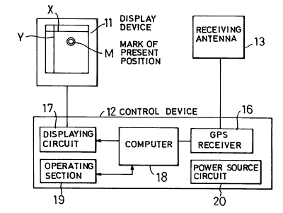
Now, in FIG. 1, there is shown an arrangement
employing an embodiment of the navigation apparatus
21 72588
according to the present invention and, in FIG. 2, the
entire arrangement of this embodiment is shown in a block
diagram. The navigation apparatus in this embodiment
generally comprises a display device 11, a control device
12, and a receiving antenna unit 13 of a GPS receiver
provided in the control device 12, and the apparatus is
provided to be placeable on or against a generally
available paper map 15 as shown schematically in FIG. 1.
The display device 11 and control device 12 are integrally
installed to an apparatus body 14, and the receiving
antenna unit 13 is mounted to an upper side face of the
body 14.
The display device 11 is designed to be capable
of presenting the latitudinal line X and longitudinal line
Y for being placed in agreement with the latitudinal and
longitudinal lines on the map, and to be provided with a
present position mark M for indicating the present
position on the map.
The control device 12 includes a GPS receiver 16
20- which performs the survey by means of electric waves
received from the GPS satellites through the receiving
antenna unit 13, and a displaying circuit 17 for carrying
out a display operation of the display device 11, so that
the latitudinal and longitudinal lines X and Y will be
displayed by the display device 11 through the displaying
circuit 17 on the basis of the data of latitude and
longitude surveyed by the GPS receiver 16.
In the above, the GPS receiver 16 continues to
2 1 72588
,
survey the latitude and longitude at intervals of about 1
second, with the electric waves transmitted from the GPS
satellites and received through the receiving antenna unit
13.
The control device 12 includes, for example, six
operating keys Kl-K6, in which the key Kl is for
displaying the present position on the display device 11
and inputting the data of present position, the key K2 is
for setting the data of types of the series of maps, the
key K3 is for setting the reduced scale of the map to be
employed, the key K4 is for setting the destination, the
key K5 is for selecting a menu, and the key K6 is for
deciding and instructing input data.
The operation of the apparatus in the present
embodiment shall be described next. First, a standard
scale of reduction of the map 15 is set to the apparatus,
and is stored preferably in a memory backed up by
batteries or such memory section (not shown) as EEPROM or
the like which holds the data even when a power source is
turned off and, as a power source switch SW provided to a
side wall of the apparatus body 14 is turned ON, a power
can be supplied from a power source circuit 20 to the
control device 12 and to the display device 11. Here, the
power source circuit 20 is constituted by a circuit which
rectifies and smooths a power from batteries or commercial
AC source or converts a DC voltage from a battery for use
in cars to a predetermined DC voltage, or a circuit which
can select one of these power source circuits.
2 1 72588
_
As the source power is supplied, the GPS
receiver 16 starts the survey of the latitude and
longitude by means of the electric waves from the GPS
satellites and received through the receiving antenna unit
13. This survey is repeated at intervals of 1 second, the
computer 18 takes up the data of results of the survey
from the GPS receiver 16 upon every completion of every
survey to obtain reference latitude and longitude on the
basis of the data taken up, the latitudinal and
longitudinal lines X and Y are made to be displayed
through the displaying circuit 17 on the display device
11, while the respective reference latitudinal and
longitudinal values are displayed along the respective
lines X and Y, and at the same time the position to be
displayed by the present position mark M is cc!lculated in
accordance with the preliminarily set rate of reduction.
In the illustrated case, the present position is surveyed
to be 13615'50" of east longitude and 3454'20" of north
latitude and is so pointed by the present position mark M,
and the reference latitude and longitude are obtained on
the basis of the surveyed data to be 13615' of east
longitude and 3455' of north latitude and are so
indicated.
Here, the navigation apparatus of the present
invention is placed on or against the map 15 so as to
overlap the latitudinal and longitudinal lines X and Y
displayed on the apparatus over the corresponding
latitudinal and longitudinal lines given on the map 15,
--10--
21 72588
then the present position mark M is to point the present
position on the map 15.
Provided here that a mountain climber carrying
the present navigation apparatus is moving in a
mountainous area or a vehicle or the like is running with
the apparatus on board, the present position mark M of the
apparatus is to move on the map, as the latitude and
longitude being surveyed is renewed. In an event when the
reference latitude and longitude indicated are caused to
vary, the user is to move the apparatus on the map 15 to
overlap the latitudinal and longitudinal lines X and Y
over the now corresponding latitudinal and longitudinal
lines on the map 15, it is made possible to recognize the
new present position on the map 15 by means of the present
position mark M.
In FIG. 3, there is shown a practical embodiment
of the navigation apparatus according to the present
invention, in which the display device 30 is constituted
by a transparent plate 30 of a square shape and fitted in
a penetrating square window made in the apparatus body 14,
a display unit 31 comprising vertical arrays 31A and
horizontal arrays 31B respectively of a plurality of light
emitting diodes and lying along both longitudinal side
edges and both latitudinal side edges of the square window
for displaying positions of the latitudinal and
longitudinal lines with two clossing pairs of the diodes
made to emit light at opposing positions in the vertical
arrays 31A and horizontal arrays 31B, which diodes being
21 72588
shown as hatched in FIG. 3, and a display 32 preferably of
liquid crystal of a type displaying the latitudinal and
longitudinal values in letters and figures at a position
on the apparatus body 14 along a lower horizontal diode
array 31B of the display unit 31. Substantially in the
center of the transparent plate 30, the present position
mark M is fixedly provided by means of small double
clrcles .
It is assumed here that the reduced rate of the
map 15 is preliminarily set and is stored, for example, in
the memory backed up by the batteries or such not shown
memory section as the EEPROM or the like which holds the
data even upon turning OFF of the power source, the
turning ON of the power source switch SW provided on the
side wall of the apparatus body 14 causes the electric
power from the power source circuit 20 to be supplied to
the control device 12 and display device 11. Other
constituents and their functions are the same as those in
the foregoing embodiment.
In FIG. 4, detailed arrangement of the
embodiment of FIG. 3 is shown, in which the GPS antenna
unit 13 is disposed on the side of the display device 11,
together with, preferably, a direction detecting means
13a. In the apparatus body 14, further, an operation
input means 19 having the operability more improved than
in the case of the foregoing embodiment and a reduced
scale interval table 18a of the latitudinal and
longitudinal lines are provided as interconnected with the
` 21 72588
computer 18, so that the operability for recognizing the
present position can be improved.
The operation of the present embodiment will be
such flow chart as shown in FIG. 5. That is, it is
assumed here that the reduced scale of the map 15 is
1/50,000, and the result of the survey by means of the GPS
receiver 16 shows 3452'10" of north latitude and
13616'40" of east longitude. The computer 18 obtains,
from a relation table as shown in FIG. 6 of the set scale
of reduction with respect to intervals between the
respective latitudinal lines and of the respective
longitudinal lines, that the interval value of the
latitudinal and longitudinal lines for the scale 1/50,000
is 1', discriminates from this value 1' and the result of
survey that the closest latitudinal and longitudinal lines
are respectively 3452' of north latitude and 13617' of
east longitude, and causes the thus discriminated values
displayed on the liquid crystal display 32 of the display
device 11.
At the computer 18, further, an operation for
determining which light emitting diodes in the arrays of
the display unit 31 should be lighted is performed. Since
the longitudinal line interval Yo and the latitudinal line
interval Xo per 1' at the position of 3452'10" are
respectively about 1523m and 1848m, so that a distance LY
between the displaying longitudinal line and the present
position will be
LY = Yo x (17'-16'40") = 1523 x (20"/60") = 508m,
21 72588
,
whereas a distance LX between the displaying latitudinal
line and the present position wil be
LX = Xo x (52'10"-52') = 1848 x (10"/60") = 308m.
Because the reduced scale of the map 15 employed
here is 1/50,000, corresponding distances Ly and Lx on the
map 15 to LY and LX will be
Ly = 508m/S0000 = lO.lmm and
Lx = 308m/50000 = 6.2mm.
In other words, the position of the displaying latitudinal
line is on south side by 6.2mm from the fixed present
position mark M disposed in the center of the transparent
plate 30, and the position of the displaying longitudinal
line is on east side by lO.lmm from the mark M.
At this time, an opposing pair of the light
emitting diodes disposed rightward by lO.lmm from the
central mark M in the opposing horizontal diode arrays 31B
lying along the upper and lower side edges of the
transparent plate 30 of the display unit 31 are lighted,
and a further opposing pair of the light emitting diodes
disposed downward by 6.2mm from the central mark M in the
opposing vertical diode arrays 31A along the left and
right side edges of the plate 30 are lighted,
respectively.
Here, as shown in FIG. 7, the apparatus body 14
is placed on the map 15 so that a line connecting between
the opposing pair of the lighted diodes in the vertical
arrays 31A as well as a further line connecting between
the further opposing pair of the lighted diodes in the
2 1 72588
horizontal arrays 31B will agree with the latitudinal and
longitudinal lines of 3452' of north latitude and 13617'
of east longitude, and the user can immediately recognize
the present position on the map 15 by means of the present
position mark M of the transparent plate 30, as will be
readily appreciated.
In another embodiment of the present invention
shown in FIG. 8, a sensor of earth magnetism direction 60
is incorporated as the direction detecting means 13a for
detecting the azimuth, and outputs of this sensor 60 are
provided to the computer 18. The azimuth detected by the
sensor 60 may be displayed with an arrow N, for example,
on part of the liquid crystal display 32 of the display
device 11. Other constituents and their functions are
substantially the same as those in the foregoing
embodiments.
In another embodiment of the present invention
shown in FIG. 9, the apparatus body 14 is divided into a
display device side section 14a and a control device side
section 14b, both of which are coupled mechanically and
electrically through a hinge part 16 to be rotatable about
an axis of the hinge part 16, and the display device side
section 14a and control device side section 14b can be
disposed as folded double. In this event, the transparent
plate 30 of the display device 11 is disposed as recessed
in the square window, so that preferably a half portion or
more in thickness direction of the control device side
section 14b can be accommodated within a recess formed on
~ 2 1 72588
the recessed transparent plate 30, and the thickness of
the apparatus even in the doulbe-folded state of the
display device side section 14a and control device side
section 14b can be thereby minimized, as will be clear
when FIGS. 9 to 12 are also referred to. In the
double-folded state, as seen in FIG. 10, the control
device 12 is visible through the transparent plate 30.
Further, the receiving antenna unit 13 is also formed as
separated from the display device side section 14a but is
mechanically and electrically coupled thereto through a
short rod 40 allowing the unit 13 rotated about the rod 40
so that, in the double-folded state, the direction sensor
60A on the unit 13 may be positioned reverse by rotating
the unit 13 by 180 degrees for simultaneous observation of
the sensor 60 with the latitudinal and longitudinal values
given on the liquid crystal display 32 kept visible
through the transparent plate 30 even in the double-folded
state, as seen in FIG. 10. All other constituents and
their functions are the same as those in the foregoing
embodiments.
In FIGS. 13 through 17, a more concrete
embodiment of the navigation apparatus according to the
present invention is shown, in which the apparatus body
also comprises the display device side section 14a and
control device side section 14b mutually foldably coupled
through the hinge part 16, while both sections 14a and 14b
are formed preferably in a plastic casing, so that the
display device side section 14a includes the transparent
-16-
2 1 72588
plate 30, diode array display unit 31, receiving antenna
unit 13 and direction sensor 60A of a compass type, and
the control device side section 14b includes the
liquid-crystal display 32, power source key PK, start key
SK, reduced-scale key K3, mode key K5, decision key K6 and
latitude and longitude controlling keys K7, respectively
as optimumly accommodated and disposed. It is also
preferable that the apparatus is formed in a
moisture-proof type, taking into account that the
apparatus of the present invention will have to be used
under such bad conditions as rainy weather and so on.
Further, as will be clear from FIG. 16, the present
position mark M provided in the center of the transparent
place 30 is made as a through hole 30A, in which event, it
is possible to provide a marking of the present position
onto the map through the hole 30A and even to record on
the map a moving locus. And the liquid crystal display 32
is formed in an arrangement of 5x7 dots as shown in FIG.
18, for realizing the required display including the
foregoing display.
Other constituents and their functions of the
present embodiment are the same as those in the foregoing
embodiments, including the double-foldable arrangement as
will be clear when FIGS. 14 and 15 are referred to, as
well as the arrangement for recognizing the present
position by placing the apparatus on the map 15 properly
in accordance with the reduced rate as will be clear from
FIG. 17.
-17-
- 21 72588
-
According to another feature of the present
invention, it is possible to realize the display of the
present position by replacing the display device 11 in the
embodiment of FIGS. 1 and 2 and comprising the transparent
plate and diode-array display unit, by a permeable type
liquid crystal display of dot-matrix structure through
which the map is visible. For this liquid crystal display
plate, one which allows things on its reverse side to be
seen from the front side is employed, and the plate is
mounted to the window penetrating through the body 14 or
the display device side section 14a.
The control device 12 may be of the same
arrangement as in the foregoing embodiments, while the
present position mark M is made operable with such
computer 18 as a microcomputer in which the desplaying
control data are prepared by the cursor, and with keys
Kl-K7 acting as an input means for providing the data to
the computer 18, in which the key K7 is employed as a
cruciform cursor.
According to the present feature, a standard
reduced-scale value is preliminarily set, and a
reduced-scale input key K3 is operated when the standard
value is different from the reduced scale of the map 15,
whereby the computer 18 is made to execute the operation
of reduced scale input mode, the reduced scale value
obtained for this time is displayed on the liquid crystal
display plate of the display device 11, and preferably the
cursor is caused to perform a flashing sign at the lowest
21 72588
place figure of the displayed figures. At this state, the
cursor position as the present position mark is shifted by
left and right switches of the cursor key K7, and the
figure below the cursor is increased or decreased by upper
and lower switches of the key K7, so that the reduced
scale value can be modified. As the reduced scale-desired
is reached, the decision key K6 is operated, the
particular reduced scale value is thereby set and, unless
the value is altered, the particular value set is employed
for the calculation of the position to be displayed by the
present position mark M by means of the computer 18 until
the power source is cut off. Instead of using the
standard value, at this time, it is also possible to so
arrange that the reduced scale input mode is attained
simultaneously with the power source connection to set the
reduced scale value before starting the survey.
In the GPS as the surveying means, a WGS84
coordinates system is used as the system for surveying the
latitude and longitude, but the coordinates system is
different between respective zones in the world so that,
when the apparatus is used in a zone where the standard
system is not of the WGS84 coordinates, the system is
required to be varied to the standard system employed in
the zone. Here, the MAPS key K2 is operated to have the
currently selected maps indicated by a flashing. The
selection of the maps is executed by shifting the cursor
in vertical and horizontal directions with the cursor key
K7 operated, the DECISION key K6 is operated when the
--19--
2 1 72588
selected maps are set, the computer 18 responds to the
operation of the DECISION key K6 to write the data of the
selected maps in a memory, and thereafter the WGS84
coordinates system is to be converted into the particular
maps.
Now, as the DESTINATION key K4 is operated after
the power source connection or in a state where the
present position is being surveyed, a lead-to-destination
mode is attained when the destination is already set, or a
destination-setting mode is reached when the destination
is not set yet, while a further operation of the
DESTINATION key K4 in the event where the destination is
already set causes the destination-setting mode to be
attained. Further, the arrangement is so made that the
completion of the destination setting or the DESTINATION
key K4 is operated in the destination-setting mode, the
original state is restored.
In the event where the destination-setting mode
is attained, further, the present position mark M of the
display device 11 is first placed on the map 15 to agree
with the position of the destination, the latitudinal line
X is shifted up and down by means of the vertical switches
of the cursor key K7 to come in agreement with a
latitudinal line closest to the destination on the map 15,
and the DECISION key K6 is operated upon the agreement.
Next, the longitudinal line Y is shifted left and right
with the horizontal switches in the cursor key K7 to be
brought into agreement with the longitudinal line closest
-20-
2 1 72588
to the destination on the map 15, and the DECISION key K6
is operated upon the agreement. At this time, the
latitudinal and longitudinal values currently being
serveyed or last surveyed are displayed on the liquid
crystal display plate of the display device 11 under the
control of the computer 18, and at the same time the
cursor is displayed in correspondence with the topmost
place of the latitudinal value. Here, the latitudinal
value of latitudinal line X being displayed is made to be
displayed with the cursor key K7 employed in the same
manner as in the foregoing setting of the reduced scale
value, and the display is decided by the DECISION key K6.
With this decision, the cursor is displayed in
correspondence to the topmost place of the longitudinal
value in the computer 18, and the longitudinal value of
the longitudinal line Y being displayed is made to be
displayed by the cursor key K7 employed in the same manner
as in the foregoing setting of the reduced scale value,
and the display is decided by the DECISION key K6.
As the foregoing operation is executed, the
computer 18 calculates the distance between the set
latitudinal and longitudinal lines and the present
position mark M, and the latitude and longitude of the
destination on the basis of the reduced scale. The
DESTINATION key K4 is operated in the state of surveying
the present position, and the lead-to-destination mode is
reached. Then the computer 18 calculates differences of
the latitude and longitude of the present position from
-21-
- 21 72588
the latitude and longitude of the destination obtained in
the destination setting mode, and a straight course
distance between the present position and the destination
as well as the direction of the destination as viewed from
the present position are thereby obtained. Then, the
straight course distance to the destination and its
direction are displayed on the liquid crystal display 32
of the display device 11, and the direction from the
present position mark M to the destination is to be
displayed.
It should be appreciated that the set mode of
the present position can be set by means of the PRESENT
POSITION key Kl, in which mode the setting of the present
position setting can be performed with the cursor key K7
and DECISION key K6 employed in the same manner as in the
destination setting.
In the respective foregoing embodiments, the
latitudinal and longitudinal lines closest to the
destination on the map 15 are sequentially followed for
the navigation by the lighted opposing diode pairs of the
vertical and horizontal light emitting diode arrays
forming the display 31 of the display device 11, or the
cursor of the liquid crystal display plate, the lighted
diodes or the cursor being shifted in vertical and
horizontal directions by means of the cursor key K7, in
accordance with a flow chart of FIG. 19.
Further, it is also possible to employ an
arrangement in which, in accordance with a flow chart of
-22-
- 2172588
FIG. 20, the latitudinal and longitudinal values surveyed
right now or the last time are displayed on the liquid
crystal display 32, and the latitudinal and longitudinal
values closest to the destination being displayed by the
lighted diodes in the light emitting diode arrays or by
the cursor of the liquid crystal display are thereby set.
-23-