Note: Descriptions are shown in the official language in which they were submitted.
21809n36
r ~ c~
-1-
MAP DISPLAY APPARATUS FOR MOTOR VEHICLE
Field of the Art
The present invention relates to a map display
apparatus for a motor vehicle, which is capable of
displaying a road map around a vehicle position on a
display device.
Background Art
There is known a map display apparatus for a motor
vehicle, which displays a road map in the form of a so-
called bird' s-eye view, namely, displays the road map on
a display device such that the road map around the
current position of the vehicle (vehicle position) is
displayed in a larger scale than a far side view (refer to
laid-open Publication No. 2-244188 of unexamined Japanese
Patent Application, for example). The apparatus
disclosed in the above-identified publication places a
view point behind the current position of the vehicle,
and displays a view taken by looking down the map from
this view point in the travelling direction of the
vehicle, on a screen of the display device. In this
manner of displaying the bird's-eye view, it is possible
to display map information around the current position in
2?80936
-2-
a larger scale, and also display a wide range of map
information ranging from the current position to a
distant place. This makes it easier to visually grasp
conditions of junctions of roads. Further, the road map
can be displayed with an increased sense of reality as if
the driver himself/herself actually looked down the road
map.
In the case where the original map information has
a little to be displayed on the screen, as in the case of
displaying a road map of a suburban area having a low
dens ity of roads , however, it is dif f icult to determine
whether a bird' s-eye view or a conventional planimetric
map is being displayed, and the sense of reality as an
intrinsic feature of the bird' s-eye view cannot be
achieved even when the bird's-eye view is displayed.
Further, upon display of the road map in the bird' s-eye
view, the map scale is continuously varied from the lower
edge of the screen toward the upper edge, making it
difficult to grasp a sense of distance.
In addition, it is true of both of the bird' s-eye
view and the planimetric map that the size of the display
screen limits a range of the road map that can be
displayed on one screen. When the destination is located
a remote distance away from the current position,
therefore, the current position and the destination may
' 2180936
-3-
not be displayed at the same time. If the destination is
not displayed, the driver is likely to make an error in
the travelling direction.
The object of the present invention is to provide a
map display apparatus for a motor vehicle, which is
capable of displaying a bird' s-eye view that makes it
easier to grasp a sense of distance and recognize the
direction of the destination.
Disclosure of the Invention
To accomplish the above object, the present
invention is applied to a map display apparatus for a
motor vehicle comprising: road map storage means for
storing road map data relating to a road map; a display
device capable of displaying the road map; bird' s-eye
view data converting means for converting the road map
data into bird' s-eye view data so that a bird' s-eye view
taken by obliquely looking down the road map from above
is displayed on the display device; and display control
means for displaying a plurality of grid lines such that
the grid lines are superposed on the bird' s-eye view.
Since the plurality of grid lines are displayed at the
same time that the bird' s-eye view is displayed, the
driver can easily grasp a sense of distance, and the
bird's-eye view can be displayed as if it were actually
2180936
-4-
present in the world.
If a display screen of the display device is divided
into regions in the vertical direction, and an image
representative of the sky, instead of the road map, is
displayed in at least one of the divided regions which is
closest to the upper edge of the display screen, the
bird' s-eye view can be displayed with higher degrees of
reality and stability.
The present invention is also applied to a map
display apparatus for a motor vehicle comprising: road
map storage means for storing road map data relating to
a road map; a display device capable of displaying the
road map; vehicle position detecting means for detecting
a current vehicle position; a destination setting means for
setting a destination of the vehicle; bird' s-eye view
data converting means for converting the road map data
into bird' s-eye view data, so that a bird' s-eye view
taken by obliquely looking down the road map from above
is displayed on the display device; determining means for
determining whether data relating to the destination is
included in the converted bird' s-eye view data or not;
and display control means for displaying a mark at a
display position corresponding to the destination if an
affirmative decision is obtained by the determining
means, and displaying the mark at a certain position in
2180936
-5-
a display screen of the display device, which position
lies in a direction of the destination, if a negative
decision is obtained by the determining means.
Since the mark indicating the direction of the
destination is always displayed irrespective of the
distance to the destination, the driver can drive while
constantly being aware of the direction of the
destination, and is thus prevented from getting lost.
Brief Description of the Drawings
Fig. 1 is a block diagram of a map display apparatus
for a motor vehicle according to the first embodiment of
the present invention.
Figs . 2A, 2B are views showing the data structure of
road data stored in a map storage memory .
Fig. 3 is a view showing an example of the road
data.
Fig. 4 is a view explaining an outline of a bird' s-
eye view displayed on a display device.
Fig. 5 is an enlarged view showing a rectangle
"abcd" of Fig. 4.
Fig. 6 is a view showing an example of grid lines
displayed at the same time that a road map is displayed
in the form of a bird' s-eye view.
Fig. 7 is a flow chart showing a main routine of a
Z a so9~6
-6-
control circuit.
Fig. 8 is a flow chart showing in detail a map
display routine of step S5 of Fig. 3.
Fig. 9 is a flow chart showing in detail a bird's-
eye view display routine of step 5102 or 5103 of Fig. 8.
Fig. 10 is a view explaining a method of calculating
a display direction angle a .
Fig. 11 is a flow chart showing in detail the
processing of 5203 of Fig. 9.
Fig. 12 is a flow chart showing in detail the
processing of S205 of Fig. 9.
Fig. 13 is a view explaining divided regions in a
display screen.
Fig. 14 is a flow chart showing in detail a
planimetric map display routine of step 5103 of Fig. 8.
Fig. 15 is a flow chart showing in detail an
appended information display routine of step S108 of Fig.
8.
Figs . 16A through 16C are views showing screen
display examples according to the first embodiment.
Fig. 17 is a block diagram of the second embodiment
of the vehicle map display apparatus of the present
invention.
Fig. 18 is a flow chart showing a bird' s-eye view
display routine of the second embodiment.
a
2I8093~
_, _
Fig. 19 is a flow chart showing a planimetric map
display routine of the second embodiment.
Figs. 20A through 20C are views showing screen
display examples according to the second embodiment.
Figs . 21A, 21B are views showing an example in which
a bird' s-eye view data are extracted from data in a
square region including a trapezoidal region "ABCD".
Best Mode for Embodying the Invention
- First Embodiment -
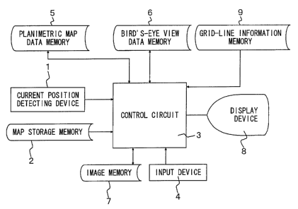
Fig. 1 is a block diagram of a map display apparatus
for a motor vehicle according to the first embodiment of
the present invention.
In Fig. 1, reference numeral 1 denotes a current
position detecting device for detecting the current
position of the vehicle, which consists of a direction
sensor for detecting the travelling direction of the
vehicle, a vehicle speed sensor for detecting a vehicle
speed, a GPS sensor for detecting GPS signals received
from a GPS (Global Positioning System) satellite, and
others . Reference numeral 2 denotes a map storage memory
for storing road map data, which is constituted by a mass
storage medium, such as CD-ROM.
The road map data stored in the map storage memory 2
consists mainly of road data, name data, background data
2 ~ ~J936
_8_
and the like.
Fig. 2 shows the data structures of road data stored
in the map storage memory 2, and Fig. 3 is a view showing
an example of the road data .
As shown in Fig. 2A, the road data are stored in
three different data storage regions, i.e., "point",
"attribute data" and "X1, Y1 . . . " . The "point" region
stores the
total number of data, and the "attribute data" region
stores codes indicative of respective kinds of roads, as
shown in Fig. 2B. The "X1, Y1 . . . " region stores
coordinates representing each of the roads. In the case
of the road data of Fig. 3, for example, coordinates of
six points shown in the figure are stored in this region.
The number of coordinates stored in the "X1, Y1 . . . "
region varies depending upon the number of intersections,
curves and the like.
Referring back to Fig. 1, reference numeral 3
denotes a control circuit for controlling the whole
apparatus, which consists of a microprocessor and its
peripheral circuits. Reference numeral 4 denotes an
input device for entering the destination of the vehicle
and others , and 5 denotes a planimetric map data memory
that stores road map data used when a display device 8
displays a planimetric map (road map of uniform scale)
2180936
-9-
obtained by viewing a road map from right above.
Reference numeral 6 denotes a bird' s-eye view data memory
that stores road map data used for displaying a bird' s-
eye view, and 7 denotes an image memory that stores data
of images displayed on the display device 8. The image
data stored in the image memory 7 are retrieved when
needed, and displayed on the display device 8. Reference
numeral 9 denotes a grid-line information memory that
stores information relating to grid lines to be displayed
on the display device 8. For instance, the information
stored in this memory 9 includes coordinates of display
positions of the grid lines, and the kind or form of the
grid lines to be displayed.
Fig. 4 is a view explaining an outline of a bird's-
eye view displayed on the display device 6. In the
example of Fig. 4, a road map extends in the XY plane,
and a view point M is placed on the Z axis that meets at
right angles with the XY plane, so as to look down the
map at an angle of ~. A rectangle "abcd" of Fig. 4,
which is shown in enlargement in Fig. 5, indicates the
size of a display screen of the display device 6, and a
trapezoid "ABCD" of Fig. 4 indicates a range of the road
map to be displayed on the display device 6.
As shown in Fig. 4, the trapezoid "ABCD" has a far
larger area than the rectangle "abcd" , which follows that
2180936
-10-
a wide range of the road map can be displayed by
employing the bird's-eye view indication. Further, a
part of the road map on the side of the lower edge ab of
the display screen of the display device 6 is displayed
to a larger scale than that on the side of the upper edge
"cd" . If the current position of the vehicle is displayed
on the side of the lower edge "ab", therefore, the vicinity
of the current position can be displayed in a larger scale.
This enables the driver to grasp detailed road map
information around the current position, and at the same
time grasp a wide range of the road map spreading out in the
direction of the destination.
For displaying the road map in the form of a bird' s-
eye view, road map data designed for bird's-eye
indication may be stored in advance in the map storage
memory 2, though this results in a tremendous amount of
data to be stored. In the present embodiment, therefore,
the ordinary road map data stored in the map storage
memory 2 is converted into bird's-eye view data through
software processing, for display on the display device 6.
If all of the road map data are converted into the
bird's-eye view data upon the conversion processing, a
part of the map on the side of the upper edge of the
display device 6 having a small scale is represented by too
large an amount of data to be displayed. In the present
~ ~ so~3~
_11_
embodiment, therefore, the road data, name data and
background data included in the road map data are ranked in
the order of priority, in view of kinds of the data, and
only the data which are given high priority are displayed on
the side of the upper edge of the display screen, and the
data that are given low priority, as well as the data of
high priority, are displayed on the side of the lower edge
of the display screen.
With regard to the road data, for example, the order
of priority is determined based on the kind of the road
stored in the "attribute data" region of the map storage
memory 2 . Thus , only expres s highways , toll roads ,
national roads and prefectural roads that are classified
in the higher rank of priority are displayed on the side
of the upper edge of the display device 6, and general
regional roads, in addition to the above-indicated roads,
are displayed on the side of the lower edge of the
display device 6.
Fig. 6 is a view showing an example of grid lines
which are displayed at the same time that the road map is
displayed in the form of the bird' s-eye view. In Fig. 6,
the grid lines are displayed such that substantially the
same distance on the road map is defined between adjacent
grid lines . Since the map scale is continuously varied
in the bird' s-eye view of the road map, the spacing
-12-
between the adjacent grid lines is gradually reduced from
the lower edge toward the upper edge of the screen, as
shown in the figure. Similarly, the spacing of the grid
lines is gradually reduced from the middle part of the
screen toward the left and right edges of the screen.
The information for displaying the grid lines of Fig. 6
is stored in advance in the above-indicated grid-line
information memory 9. In Fig. 6, numerical values
appearing aside the screen indicate coordinates of
display positions when the origin is placed at the lower
and left end of the screen, and the triangular mark in
the screen represents the current position of the
vehicle.
Fig. 7 is a flow chart showing a main routine of the
control circuit 3. In the following, the operation of
the first embodiment will be explained on the basis of
this flow chart. The control unit 3 initiates the
routine of Fig. 7 when a key is operated to turn on an
ignition switch, for example.
In step S1 of Fig. 1, recommended route and
destination are established. Described in more detail,
the destination is determined on the basis of information
entered through the input device 4, and the recommended
route is determined by calculating according to a known
Dykstra method, for example. The recommended route may
2180936
-13-
be selected from a number of proposed recommended routes
that are preliminarily stored in ROM or the like.
In the next step S2, a display screen mode is
selected. The control circuit 3 has display screen modes
including: a mode for displaying a bird' s-eye view of the
road map; a mode for displaying a planimetric map; and a
mode for displaying the bird' s-eye view and planimetric
map at the same time. The operator selects one of these
modes through the input device 4. Upon selection of the
mode for displaying the bird' s-eye view and planimetric
map at the same time, the road map of one of these views
is displayed in a base screen region having a large
display area, while the road map of the other view is
displayed in a window screen region as a part of the base
screen.
Step S3 is then executed to establish display
environments. The display environments set in this step
include colors displayed on the screen, map scale of the
road map to be displayed, and others . These display
environments are selected by the operator through the
input device 4.
In the next step S4, the current position of the
vehicle is detected. Step S5 is then executed to
implement a map display routine as shown in detail in
Fig. 8. The map display routine will be described later
~' ~ 8093
-14-
in detail.
In the next step S6, the current position of the
vehicle is detected in the same manner as in step S4.
Step S7 is then executed to determine whether the road
map on the screen should be updated or not, namely,
whether the road map should be rewritten or not. In this
step, it is determined to update the road map when the
vehicle runs farther than a predetermined distance, or
when the operator enters a command for scrolling by means
of the input device 4, for example.
If an affirmative decision is obtained in step S7,
the control flow returns to step S5. If a negative
decision is obtained in step S7, step S8 is then
implemented to determine whether the main routine of Fig.
7 is continued or not. A negative decision is obtained
in step S8 if a power switch that is not shown in the
figure is turned off, or when a switch is operated to
cancel the routine, and the main routine of Fig. 7 is
terminated.
If an affirmative decision is obtained in step S8,
the control flow goes to step S9 to update the appended
information to be displayed, and then returns to step S6.
The appended information mentioned herein may include a
vehicle position mark displayed at a position
corresponding to the current position of the vehicle.
210936
-15-
The control flow returns to step S6 after the display
position of the appended information, such as the vehicle
position mark, is changed in the above step S9 according.
to the travel distance of the vehicle. In the case where
such vehicle position marks are displayed on both the
base screen and the window screen, the display positions
of both of the vehicle position marks are changed.
Fig. 8 is a detailed flow chart of the map display
routine of step S5 of Fig. 3. In step S101 of Fig. 8, it
is determined whether the road map to be displayed on the
base screen is in the form of a bird' s-eye view or not .
This determination is effected on the basis of the
display screen mode selected in step S2 of Fig. 7. If an
affirmative decision is obtained in step 5101, step 5102
is then executed to effect a bird's-eye view display
routine as shown in detail in Fig. 9, so that the bird' s-
eye view is displayed in the base screen region on the
screen.
If a negative decision is obtained in step S101, on
the other hand, the control flow goes to step S103 to
implement a planimetric map display routine as shown in
detail in Fig . 14 , so that the bird' s-eye view is
displayed in the base screen region on the screen.
Upon completion of the routine of step 5102 or S103,
step 5104 is then executed to determine whether a display
2~~0936
-16-
is provided on the window screen or not . This
determination is effected on the basis of the display
screen mode selected in step S3 of Fig. 7.
If an affirmative decision is obtained in step 5104,
the control flow goes to step 5105 to determine the road
map displayed on the window screen is in the form of a
bird's-eye view or not. This determination is also
effected on the basis of the display screen mode selected
in step S2 of Fig. 7. If an affirmative decision is
obtained in step S105, step 5106 is then executed to
implement the bird' s-eye view display routine as shown in
detail in Fig. 9 so as to display the bird's-eye view in
the window screen. If a negative decision is obtained in
step S105, on the other hand, step S107 is then executed
to implement the planimetric view display routine as
shown in detail in Fig. 14 so as to display the
planimetric view in the window screen.
When the routine of step S106 or 5107 is terminated,
or when a negative decision is obtained in step S104,
step 5108 is executed to implement an appended
information display routine as shown in detail in Fig.
15, so that appended information, such as a vehicle
position mark, is displayed on both the base screen and
window screen, and the control flow returns to the main
routine. Step S108 will be described later in detail.
2?80936
-17-
Fig. 9 is a detailed flow chart of the bird's-eye
view display routine of step 5102 or S106 of Fig. 8. In
step S201 of Fig. 9, a display direction angle used for
display of the bird's-eye view is calculated.
Fig. 10 is a view explaining a method for calculating
the display direction angle a . The XY axes shown in the
figure define a road map plane in which the origin 0
represents the departure point of the vehicle, and the
coordinates G (X0, YO) represent the current position of
the vehicle, while the coordinates P1 (X1, Y1) represent
the destination.
As shown in the figure, the display direction angle
a is an angle formed by a segment ( indicated by a dotted
line in the figure) connecting the current position G and
the destination P1, and the X axis, and is represented by
the equation ( 1 ) .
tana = {{Y1 - YO)/(X1 - XO)} ~ ~ ~ (1)
In the above-described step S201, the display
direction angle a is obtained on the basis of the
equation (1).
In the next step 5202, the road map data around the
current position is retrieved from the map storage memory
2 on the basis of the current position detected in step
S4 of Fig. 7, and the display direction angle a calculated
in step S201. For example, the road map data is retrieved
L
2 ~ ~~936
-18-
with respect to an area within a several tens of kilometers
square including the current position.
In the next step 5203, data used for displaying the
bird' s-eye view are selected from the road map data
retrieved in step S202, and the selected data are stored
i
in the bird' s-eye view data memory 6 as detailed in Fig. 11.
The processing of step S203 will be described later in
detail. In the next step S204, the road map data selected in
step 5203 is converted into bird' s-eye view data .
In the next step S205, the bird' s-eye view data obtained
in step S204 is converted into map image data for displaying
final images on the display device 8 as detailed in Fig. 12.
The processing of step S205 will be described later in
detail. In the next step S206, grid-line information
used for display of the bird' s-eye view is retrieved from
the grid-line information memory 9, and combined with the
map image data. The combined data is then stored in the
image memory 7, and the control flow returns to the map
display routine.
Fig. 11 is a detailed flow chart of the processing
of step 5203 of Fig. 9. In step S301 shown in the
figure, data that have not been processed in step S302
and subsequent steps (which will be explained) are
selected from the road map data retrieved in step 5202 of
Fig. 9. Step S302 is then executed to determine whether
-19-
2180936
the kind of the data selected in step 5301 is one of
those kinds which should be displayed on the display
device 6. In the case where the data selected in step
S301 are road data, for example, it is determined whether
the road data represent a kind of road whose order of
priority is above that of national roads or not . As a
,Y result of the processing of this step 5302, the amount of
a
the road map data displayed on the display device 6 is
f
reduced.
If an affirmative decision is obtained in step 5302,
step 5303 is then executed to determined whether the data
selected in step S301 are within a range that is to be
displayed on the display device 6 or not. Namely, it is
determined whether the data selected in step S301 is in
the range of the trapezoidal area ~~ABCD~~ of Fig. 4.
If an affirmative decision is obtained in step 5303,
step 5304 is then executed to select the data selected in
step 5301 as data to be converted into bird' s-eye view
data.
When the processing of step 5304 is completed, or
when a negative decision is obtained in step 5302, or
when a negative decision is obtained in step 5303, step
5305 is then executed to determine whether all of the
data retrieved from the map storage memory 2 in step S302
of Fig. 9 have been processed according to steps S301 -
2i$09~b
-20-
S304 or not, and the control flow returns to the bird' s-
eye view display routine if an affirmative decision is
obtained. If a negative decision is obtained, the control
flow goes back to step S301.
In the above-described processing of Fig. 11, the
control circuit 3 filters the road map data retrieved
from the map storage memory 2, so as to extract only the
data of such kinds that satisfy given requirements, and
then select the data used for bird' s-eye view indication
from the extracted data.
Fig. 12 shows a detailed flow chart of the
processing of step S205 of Fig. 9. In step S401 of Fig.
12, such data that have not been converted into map image
data are selected from the bird' s-eye view data obtained
as a result of the processing of step S204 of Fig. 9. In the
next step S402, the display range of the display device 6 is
divided into a plurality of regions, and the number of
the divided regions is substituted for variable N.
As shown in Fig. 13, the display device 6 of the
present embodiment has a display screen having 500 dots
in the X-axis direction and 400 dots in the Y-axis
direction. This display screen is divided into four
regions in the vertical direction, and the origin of the
coordinates is located at the left, lower corner of the
display screen. In the following description, the first
-21-
2180936
region represents an area in which the coordinates in the
Y-axis direction are in the range of 0 to 199 dots, and
the second region represents the range of 200 to 299
dots. The third region covers the range of 300 to 349
dots, and the fourth region covers the range of 350 to
399 dots.
In step S403 of Fig. 12, it is determined whether the
display position of the data selected in step 5401 is within
the N region or not. If a negative decision is obtained,
step S404 is then executed to subtract 1 from the variable N
to update N, and the control flow returns to step S403.
If an affirmative decision is obtained in step S403,
step 5405 is then executed to convert the bird's-eye view
data into map image data, on the basis of the value of
valuable N. For example, lines representing roads in the
first region have a width of 4 points, and lines
representing roads in the second region have a width of
2 points, while lines representing roads in the third
region have a width of 1 point. The map image data may
be produced such that an image representative of the sky
( for example, blue or bluish image ) is displayed in the
fourth region, instead of the road map. In this case,
the display color of the fourth region may be changed
from day to night. That is, the image may be displayed
with a bright color by day, and with a dark color by
2180936
-22-
night.
In the next step S406, it is determined whether all
of the bird ~ s-eye view data have been converted into map
image data . I f a negative decis ion is obtained, the
control flow goes back to step S401. If an affirmative
decision is obtained, the control flow returns to the
bird's-eye view display routine.
f
In the above-described processing of Fig. 12, the
display range of the display device 6 is divided into a
IO plurality of regions, and the form of display of the
bird ~ s-eye view data is changed for each of the regions .
Accordingly, an increased sense of three-dimensional
bird ~ s-eye view can be displayed, making it easier for the
operator to grasp a feeling of distance. In particular, the
bird's-eye view
is given further increased presence if the image
representing the sky rather than the road map is
displayed in the fourth region closest to the upper edge
of the display device.
Fig. 14 is a detailed flow chart of the planimetric
map display routine of step 5103 of Fig. 8. In step 5501
of Fig. 14, the road map around the current position of
the vehicle is retrieved from the map storage memory 2.
In the next step 5502, data used for planimetric map
indication are selected from the road map data retrieved
218093b
-23-
in step S501, and the selected data is stored as
planimetric map data in the planimetric map data memory
5. In this step S502, data sorted in the relatively high
rank of priority or the like is selected in the same manner
as in step 5203 of Fig. 9.
In the next step 5503, the planimetric map data
stored in the planimetric map data memory 5 are converted
into map image data. In the next step S504, grid-line
information used for planimetric map indication is
retrieved from the grid-line information memory 9, and
combined with the map image data . Thereafter, the
combined data is stored in the image memory 7 , and the
control flow returns to the map display routine.
Fig. 15 is a detailed flow chart of the appended
information display routine of step S108 of Fig. 8. In
step S601 of Fig. 15, vehicle position mark data are
prepared to display a triangular mark as shown in Fig. 13
at a display position corresponding to the current
position G of the vehicle. In the next step 5602, a
distance GP between the current vehicle position G and
the destination P is obtained. Step S603 is then
executed to determine whether the distance GP is equal to
or smaller than a predetermined distance L. The
predetermined distance L is a distance between the
current position G and a point of intersection F at which
'" 2180936
-24-
a segment connecting the current position G and the
destination P intersects with the display range ~~ABCD" of
the road map, as shown in Fig. 10: Namely, it is
determined in step S603 whether the destination P is
within the range of display of the display device 6.
If an affirmative decision is obtained in step S603,
the control flow goes to step 5604 to prepare destination
mark data so as to display a flag mark as shown in Fig.
13 at a display position corresponding to the destination
P. The control flow then returns to the map display
routine. If a negative decision is obta-fined in step
S603, step S605 is then executed so that the control
circuit 3 prepares destination mark data so as to display
the flag mark at the point of intersection F shown in
Fig. 10.
When the destination mark data is prepared in the
above step 5604 or 5605, the size of the flag mark is
changed depending upon the display position of the
destination. For example, the flag mark has the largest
size when the destination is within the first region of
Fig. 13. Then, the flag mark has the second largest size
when the destination is within the second region, and has
the smallest size when the destination is within the
third region. Fig. 13 shows flag marks having respective
display sizes, which are located in the second and third
2180936
-25-
regions.
As described above, the fourth region may be used to
display the image representing the sky. Therefore, the
above-described predetermined distance L may be made a
little shorter than the distance from the current
position G to the point of intersection F of Fig. 10, so
that the flag mark is not displayed in the fourth region.
In this arrangement, the flag mark is not displayed in
the fourth region, and is displayed in any one of the
f first through third regions on which the road map is
displayed, thus allowing an easy view of the road map on
the screen.
In the above-described routine of Fig. 15, the flag
mark is displayed at the display position corresponding
to the destination when the destination is present within
the range of display of the display device 6. When the
destination is outside the display range, the flag mark
is displayed at a display position on the display screen,
which lies in the direction of the destination and is
closest to the destination. In this arrangement, the
flag mark can be displayed irrespective of the distance
from the current position to the destination, permitting
the driver to be always aware of the direction of the
destination. Since the size of the flag mark is changed
depending upon the display position on the display
218093b
-26-
screen, the flag mark does not interfere with indication
of the other map information.
Fig. 16 are views showing examples of screen display
according to the first embodiment, wherein Fig. 16A is a
display example taken before movement of a motor vehicle,
and Fig. 16B is a display example taken after the vehicle
moves a given distance in a travelling direction, while
Fig. 16C is a display example taken upon a significant
change of the travelling direction of the vehicle. In
any example of Figs . 16A - 16C, grid lines are displayed
at the same positions on the screen. The grid lines are
indicated by dotted lines in the figures . The flag mark
indicating the destination is displayed in a size that
becomes larger as the vehicle approaches the destination.
The operation of the first embodiment as explained
above will be described in short. When the vehicle
starts running, the control circuit 3 detects the current
position of the vehicle, and calculates the display
direction angle used for the bird ~ s-eye view indication,
from the positional relationship between the current
position and the destination. Then, the control circuit
3 retrieves appropriate road map data from the map
storage memory 2, on the basis of the current position,
destination and the display direction angle. The
retrieved road map data are then filtered to extract data
' 2) 80936
of such kinds that satisfy given requirements, and the
extracted data are converted into bird ~ s-eye view data .
Subsequently, the control circuit 3 divides the
display screen of the display device 6 into a plurality
of regions, and the bird's-eye view data are processed
for each region, to be converted into map image data.
For example, some roads present in the region near the
lower edge of the display screen are represented by lines
having a large width, and other roads present in the
region near the upper edge of the display screen are
represented by lines having a small width.
In the next step, the control circuit 3 prepares
vehicle information image data for displaying marks
indicating the current vehicle position and the
destination. In this step, the mark data are prepared so
that the mark is displayed at a display position
corresponding to the destination when the destination is
within a range of display, and so that the mark is
displayed at a display position that lies in the
direction of the destination and is closest to the
destination, when the destination is located outside the
display range.
Upon completion of preparation of the map image data
and the vehicle information image data, the control
circuit 3 displays these data on the display device 6,
218J936
-28-
and then detects the current vehicle position again. If
the vehicle does not run farther than a predetermined
distance, only the display position of the vehicle
position mark is changed. If the vehicle runs farther
than the predetermined distance, the map image data are
updated.
In the meantime, grid line information used for
bird's-eye view indication and planimetric map indication
are stored in advance in the grid line information memory
9. The control circuit 3 selects appropriate grid-line
information in accordance with the screen display mode
selected by the operator, and, when the road map is
displayed, the selected grid lines are also displayed as
superposed on the road map.
Thus, according to the first embodiment, the grid
lines are displayed at an interval of a given distance on
the road map, to allow the operator to easily grasp a
sense of distance, while displaying the bird' s-eye view
with increased reality. Since the grid lines are always
displayed at fixed display positions, the grid lines need
not be rewritten even when the road map on the screen is
scrolled. Thus, the grid lines can be displayed without
affecting the speed of updating the map. Further, even
when the destination is located at such a remote distance
that it is not displayed on the screen, the flag mark
' 2180936
-29-
indicating the destination is displayed at a certain
position on the screen which lies in the direction of the
destination. This allows the driver to drive with a
constant grasp of the direction of the destination,
without getting lost. Since the size of the flag mark
indicating the destination is varied depending upon its
display position, the flag mark does not interfere with
indication of other map information. Moreover, the
display range of the display device 6 is divided into a
plurality of regions, and data to be displayed are
selected for each of the regions, depending upon the kind
of the data. Accordingly, detailed map information can be
displayed around the current position, and only important
map information can be displayed in the region closer to
the destination, thus allowing an easy view of the road
map on the display screen. In addition, the bird' s-eye
view is given a touch of three dimensions since the
control circuit 3 changes the line width of roads for
each region on the display screen.
- Second Embodiment -
In the second embodiment, lines of latitudes or
parallels and lines of longitudes or meridians on a road
map are displayed as grid lines .
Fig. 17 is a block diagram of the second embodiment
of the vehicle map display apparatus of the invention.
210936
-30-
As shown in Fig. 17, the second embodiment is identical
with the first embodiment as shown in Fig. 1 except that
the second embodiment does not have a grid line
information memory. Of various routines implemented by
the control circuit 3, only the bird's-eye display
routine and planimetric map display routine are different
from those of the first embodiment. In the following
description, therefore, the bird's-eye display routine
and planimetric map display routine will be mainly
explained.
In the map storage memory 2 of the second embodiment,
there are stored information relating to the latitudes and
longitudes on the road map .
Fig. 18 is a flow chart showing the bird' s-eye view
display routine of the second embodiment. The
processing of steps S701, S702 of Fig. 18 are identical
with those of steps 5201, S202 of Fig. 9. In the next step
5703, the information relating to the latitudes and
longitudes (hereinafter referred to as latitude~longitude
data)
stored in the map storage memory 2 is retrieved. In the
next step S704, road map data in the range of display of the
display device 8 are selected and stored in the bird' s-
eye view data memory 6. In the next step S705, the
latitude longitude data retrieved in step S703 are
2180936
-31-
converted into bird' s-eye view data so that the parallels
and meridians are displayed with the bird' s-eye view on
the screen.
In the next step S706, the road map data selected in
step S704 are converted into bird's-eye view data. In
the next step 5707, the bird's-eye view data obtained in
steps S705 and S706 are converted into map image data,
which are then stored in the image memory 7. Thereafter,
the control flow returns to the map display routine.
Fig. 19 is a flow chart showing a planimetric map
display routine of the second embodiment. The
processing of steps 5801, S803 of Fig. 19 are identical
with those of steps 5501, S503 of Fig. 14. In step S502,
the latitude- longitude data stored in the map storage
memory 2 are retrieved. In step 5504, the road map data
selected in step S503 and the latitude longitude data
retrieved in step 5502 are converted into map image data,
which is then stored in the image memory 7. Thereafter,
the control flow returns to the map display routine.
Fig. 20 are views showing an example of screen
display of the second embodiment, wherein grid lines
indicated by dotted lines in the figures represent the
parallels and meridians on the road map . Fig . 2 OA is a
display example taken before movement of a motor vehicle,
and Fig. 20B is a display example taken after the vehicle
~' ~ 8093
-32-
runs a predetermined distance in a travelling direction,
while Fig. 20C is a display example taken upon a
significant change of the travelling direction of the
vehicle.
In the present embodiment, the vehicle position mark
is displayed at a fixed position on the screen as a
general rule. Therefore, the range of the road map on
the screen is changed when the vehicle moves beyond a
predetermined distance as shown in Fig. 20B, and the
display positions of the grid lines indicating the
parallels and meridians are also changed in accordance
with the above change. When the road map range on the
screen is rotated with a change of the travelling
direction of the vehicle as shown in Fig. 20C, the
display positions of the grid lines are also rotated
according to the rotation of the road map.
The lateral grid lines A, B, C on the screen in Fig.
20A are shifted to Al, B1, C1 in Fig. 20B, and to A2, B2,
C2 in Fig. 20C.
According to the second embodiment as described
above, the parallels and meridians on the road map are
displayed as the grid lines, thereby allowing the driver
to grasp the current position of the vehicle with higher
accuracy. Further, the display positions of the grid
lines are changed according to a change of the road map
~f 80936
-33-
range on the screen. This makes it easier to grasp a
degree of changes of the travelling distance and
travelling direction of the vehicle.
In step 5203 of Fig: 9 and step 5704 of Fig. 18,
data present in the trapezoidal range ABCD of Fig. 4 are
selected as bird's-eye view data. To increase the
processing speed, however, data present in a square
region ( hatched area in the figure ) including the
trapezoidal region ABCD as shown in Fig. 21A may be
selected as bird' s-eye view data, and coordinates in the
whole range of the selected square region may be
converted.
Fig. 21B shows an example of coordinate conversion
of the square region of Fig. 21A. A rectangular region
"abcd" in the middle portion of Fig. 21B indicates a
range that is actually displayed on the display device 6.
When the road map data in a wider range than the display
range of the display device 6 are converted into bird' s-
eye view data in this manner, the processing of steps
5201-S204 of Fig. 9 or steps S701-5705 of Fig. 18 need
not be carried out when the vehicle moves after display
of the current bird' s-eye view, as long as the data to be
used are within the square range of Fig. 21A. Namely,
the bird' s-eye view can be updated or rewritten by merely
shifting the rectangular region of Fig. 21B for display,
' 2' l 00936
-34-
assuring increased updating speed.
In the illustrated embodiment, parameters, such as
the height of the view point, looking-down and looking-
around angles used for bird' s-eye view indication, are
established so that the direction of the destination is
indicated. These parameters, however, may be changed as
desired by the user. In this case, the range of the
trapezoidal region "ABCD" of Fig. 4 may be determined, on
the basis of data, such as the height of the view point,
that are set by the driver by means of the input device
4, for example. The wider range of road map can be
displayed with an increase in the height of the view
point, and the bird' s-eye view looks closer to an
ordinary planimetric map as the looking-down angle
increases. Thus, these parameters may be changed as
desired so as to display a desired range of the road map
in the form of a bird' s-eye view. Further, the reduction
scale of the bird' s-eye view may be also changed as
desired, thus increasing the flexibility with which the
bird's-eye view is displayed.
It is also possible to provide a mode in which a
road map in a narrow range around the current position is
displayed in a bird' s-eye view, and a mode in which a
wide range of road map is displayed in a bird' s-eye view,
so that one of these modes can be selected as desired by
2180936
-35-
a selecting switch, for example.
While the bird' s-eye view is normally displayed on
the display device 6 in the illustrated embodiments, a
selecting switch, for example, may be operated to
arbitrarily select whether the bird' s-eye view is
displayed or an ordinary planimetric map is displayed.
For example, the planimetric view is advantageous for
measurement of a distance between two points on a map.
By allowing arbitrary selection of the map display mode,
the road map can be displayed with increased flexibility.
In the illustrated embodiments, the view point is
placed above around the current position of the vehicle,
and the road map is looked down from this view point in
the direction of the destination. In some cases,
however, it is more convenient to display the bird's-eye
view obtained by looking down the road map in the
travelling direction of the vehicle, depending upon road
conditions and others . It may be therefore better to
enable the operator to select whether a view taken in the
direction of the destination is to be displayed or a view
taken in the travelling direction is to be displayed, by
means of a selecting switch, for example. Alternatively,
the direction in which the road map is looked down may be
automatically switched so as to display a bird' s-eye view
z~ so936
-36-
obtained by looking down the road map in the direction of
the destination while the vehicle is running on a
recommended route, and display a .bird' s-eye view obtained
by looking down the map in the vehicle travelling
direction when the vehicle deviates from the recommended
route.
Although the line width of roads is changed for each
region in the display screen of the display device 6 in
the illustrated embodiments, the size of characters or
symbols in the name data may be changed for each region.
Namely, the size of the characters or the like displayed
near the upper edge of the display device 6 may be made
smaller than that near the lower edge .
In the illustrated embodiments, the flag mark is
displayed in the direction, of the destination even if the
destination is outside the display range of the display
device. In this case, the flag mark may be displayed
with a different color or shape from that of the normal
flag mark indicating the real destination, so as to
discriminate between the provisional and real
destinations.
While the road line width is changed for each region
on the display screen so as to give a touch of three
dimensional view in the illustrated embodiments, the
color may be changed for each region. For example, the
- ~~ 8093b
-37-
region near the lower edge of the display screen is
displayed with brighter colors than that near the upper
edge, so as to increase the touch of three-dimensional
view.
Although the vehicle is guided according to the
recommended route obtained by calculation in the
illustrated embodiments, the present invention is not
limited to such map display apparatus that is provided
with the vehicle guiding function. Namely, the present
invention is applicable to an apparatus for displaying a
bird' s-eye view of a road map on the basis of established
current position and destination.
While the parallels and meridians on the road map
are displayed as the grid lines in the second embodiment,
the unit of degrees of latitude and longitude by which
the grid lines are displayed may be selected as desired.
In the first embodiment, the grid lines may be
graduated at respective sides for display, to inform the
operator of how many meters is the distance between
adjacent grid Lines. In the second embodiment; each grid
line may be displayed with the corresponding degree of
latitude or longitude.
In the illustrated embodiments, a plurality of kinds
of lines may be provided for respective grid lines, and
the grid lines may be displayed using the different kinds
~10093b
-38-
of lines . For example, thin grid lines may be displayed
at an interval of several hundreds of meters, and thick
grid lines may be displayed at an interval of several
kilometers . If the grid lines near the lower edge of the
screen are displayed with thick lines, and the grid lines
near the upper edge are displayed with thin lines, the
road map can be displayed with increased reality.
Apart from the illustrated embodiments, the current
position of the vehicle may be considered as a reference
point, and grid lines may be displayed in accordance with
the distance from the current position. This makes it
further easier to grasp an approximate distance from the
current position.
Availability in the Industry
As described above, the map display apparatus for
the motor vehicle according to the present invention is
adapted to display a bird' s-eye view along with grid
lines in the display screen of the display device, so
that the bird' s-eye view is displayed as if it were
actually present in the world. Since an image
representing the sky, rather than the road map, is
displayed on the side of the upper edge of the display
screen, the bird' s-eye view can be displayed with higher
degrees of reality and stability. Further, a mark
o..
~18093b
-39-
indicating the destination is displayed whereby the
driver can drive with a constant knowledge of the
direction of the destination, and is thus less likely to
get lost .