Note: Descriptions are shown in the official language in which they were submitted.
21~Q937
-1-
MAP DISPLAY APPARATUS FOR MOTOR VEHICLE
Field of the Art
The present invention relates to a map display apparatus for
a motor vehicle, which is capable of displaying a road map in
the vicinity of a vehicle position on a display device.
Background Art
There is known a map display apparatus for a motor vehicle,
which displays a road map in the form of a so-called bird' s-eye
view, namely, displays the road map on a display device such
that the road map around the current position of the vehicle
(vehicle position) is displayed in a larger scale than a far
side view (refer to laid-open Publication No. 2-244188 of
unexamined Japanese Patent Application, for example). The
apparatus disclosed in the above-identified publication places
a view point behind the current position of the vehicle, and
displays a view taken by looking down the map from this view
point in the travelling direction of the vehicle, on a screen of
the display device. In this manner of displaying the bird's-eye
view, it is possible to display map information around the
current position in a larger scale, and also display a wide
range of map information ranging from the current position to a
distance place. This makes it easier to visually grasp
connecting conditions of junctions of roads. Further, the road
_2_
map can be displayed with an increased sense of reality as if
the driver himself/herself actually looked down the road map.
When the road map is displayed in the form of the bird' s-eye
view, however, the map scale is continuously varied from the
lower edge of the screen toward the upper edge, making it
difficult for the driver to grasp a sense of distance. When the
driver is not accurately aware of road conditions around the
vehicle position, as in the case where the vehicle is running
through an area that is unfamiliar to the driver, it is more
desirable to display an ordinary planimetric map on a map scale
that does not vary in local parts of the map, rather than
displaying the bird's-eye view.
If the processing for displaying the road map in the form of
the bird's-eye view is effected using road map data independent
of road map data used for displaying a planimetric map, there
arises a need to newly add the road map data for the bird' s-eye
view, which may increase the cost of the apparatus .
It is an object of the present invention to provide a map
display apparatus for a motor vehicle, which is capable of
selecting as desired the map form of the road map displayed on
the display device. It is another object of the present
invention to provide a map display apparatus for a motor
vehicle, which is able to display road maps in a plurality of
different map forms at the same time. It is a further object of
the present invention to provide a map display apparatus for a
CA 02180937 2003-11-21
-3-
motor vehicle, which is able to display road maps of
different map forms, using the same map data base.
Summary of the Invention
In accordance with one aspect of the present invention
there is provided a road map display control method for a
motor vehicle for controlling to display a road map on a
screen of a display device, comprising: defining a mode in
which a planimetric map is displayed, the planimetric map
having a range based upon a set map scale and having a map
scale that is constant within the screen of the display
device, a mode in which a bird's-eye view is displayed, the
bird's-eye view being taken by looking down in a traveling
direction of the vehicle from a view point set above a
vicinity of a vehicle position and having a map scale
varying within the screen of the display device to display a
road map around the vehicle position in a larger scale than
a far side view, and a mode in which the planimetric map and
the bird's-eye view are displayed at the same time;
detecting the vehicle position by a vehicle position
detecting device; and controlling by a display control
device to display at least one of the planimetric map and
the bird's-eye view based upon either one of said modes and
a mark indicating the detected vehicle position in the
planimetric map and the bird's-eye view.
CA 02180937 2003-11-21
-4-
In accordance with another aspect of the present
invention there is provided a road map display control
apparatus for a motor vehicle that controls to display a
road map on a screen of a display device, comprising: a
vehicle position detecting device that detects a vehicle
position; a display control device that controls to display
at least one of a planimetric map and a bird's-eye view
based upon either one of a mode in which the planimetric map
is displayed, a mode in which the bird's-eye view is
displayed, and a mode in which the planimetric map and the
bird's-eye view are displayed at the same time, and a mark
indicating the detected vehicle position is displayed in the
planimetric map and the bird's-eye view; the planimetric map
having a range based upon a set map scale and having a map
scale that is constant within the screen of the display
device; and the bird's-eye view being taken by looking down
in a traveling direction of the vehicle from a view point
set above a vicinity of the vehicle position and having a
map scale varying within the screen of the display device to
display a road map around the vehicle position in a larger
scale than a far side view.
In accordance with yet another aspect of the present
invention there is provided a road map display control
method for a motor vehicle for controlling to display a road
map on a screen of a display device, comprising: determining
a destination of the vehicle; determining a recommended
CA 02180937 2003-11-21
-4a-
route from a departure point to the destination of the
vehicle; and changing a number of display regions on the
screen from one to two when a vehicle position approaches a
guidance point on the recommended route necessary for route
guidance, wherein: a road map that is displayed on the one
display region before changing the number is a bird's-eye
view being taken by looking down obliquely from above; and
road maps that are displayed on the two display regions
after changing the number are a planimetric map around the
guidance point and the bird's-eye view.
In accordance with still yet another aspect of the
present invention there is provided a road map display
control method for a motor vehicle for controlling to
display a road map on a screen of a display device based
upon a road map data for displaying a planimetric map,
comprising: determining a destination of the vehicle;
determining a recommended route from a departure point to
the destination of the vehicle; and changing a number of
display regions on the screen from one to two when a vehicle
position approaches a guidance point on the recommended
route necessary for route guidance, wherein: a road map that
is displayed on one of the two display regions is a bird's-
eye view being taken by looking down obliquely from above
generated based upon the road map data for displaying a
planimetric map; and a road map that is displayed on another
one of the two display regions is a planimetric map
CA 02180937 2003-11-21
-4b-
generated based upon the road map data for displaying a
planimetric map.
In accordance with still yet another aspect of the
present invention there is provided a road map display
control method for a motor vehicle for controlling to
display a road map on a screen of a display device,
comprising: determining a destination of the vehicle;
determining a recommended route from a departure point to
the destination of the vehicle; and changing a number of
display regions on the screen from one to two when a vehicle
position approaches a guidance point on the recommended
route necessary for route guidance, wherein: a road map that
is displayed on one of the two display regions is a bird's-
eye view being taken by looking down obliquely from above
and including a vehicle position mark with a traveling
direction of the vehicle oriented to a top of the screen;
and a road map that is displayed on another one of the two
display regions is a planimetric map including a vehicle
position mark of the vehicle with a traveling direction of
the vehicle oriented to a top of the screen.
In accordance with still yet another aspect of the
present invention there is provided a road map display
control apparatus for a motor vehicle that controls to
display a road map on a screen of a display device,
comprising: a destination setting device that determines a
destination of the vehicle; a recommended route setting
CA 02180937 2003-11-21
-4c-
device that determines a recommended route from a departure
point to the destination of the vehicle; and a display
control device that changes a number of display regions on
the screen from one to two when a vehicle position
approaches a guidance point on the recommended route
necessary for route guidance, wherein: a road map that is
displayed on the one display region before changing the
number is a bird's-eye view being taken by looking down
obliquely from above; and road maps that are displayed on
the two display regions after changing the number are a
planimetric map around the guidance point and the bird's-eye
view.
In accordance with still yet another aspect of the
present invention there is provided a road map display
control apparatus for a motor vehicle that controls a
display a road map on a screen of a display device based
upon a road map data for displaying a planimetric map,
comprising: a bird's-eye view generation device that
generates a bird's-eye view being taken by looking down
obliquely from above based upon the road map data for
displaying a planimetric map; a planimetric map generation
device that generates a planimetric map based upon the road
map data for displaying a planimetric map; a destination
setting device that determines a destination of the vehicle;
a recommended route setting device that determines a
recommended route from a departure point to the destination
CA 02180937 2003-11-21
-4d-
of the vehicle; and a display control device that changes a
number of display regions on the screen from one to two when
a vehicle position approaches a guidance point on the
recommended route necessary for route guidance, wherein: a
road map that is displayed on one of the two display regions
is the bird's-eye view generated by the bird's-eye view
generation device; and a road map that is displayed on
another one of the two display regions is the planimetric
map generated by the planimetric map generation device.
In accordance with still yet another aspect of the
present invention there is provided a road map display
control apparatus for a motor vehicle that controls to
display a road map on a screen of a display device,
comprising: a bird's-eye view generation device that
generates a bird's-eye view being taken by looking down
obliquely from above; a planimetric map generation device
that generates a planimetric map; a destination setting
device that determines a destination of the vehicle; a
recommended route setting device that determines a
recommended route from a departure point to the destination
of the vehicle; and a display control device that changes a
number of display regions on the screen from one to two when
a vehicle position approaches a guidance point on the
recommended route necessary for route guidance, wherein: a
road map that is displayed on one of the two display regions
is a bird's-eye view being taken by looking down obliquely
CA 02180937 2003-11-21
-4e-
from above and including a vehicle position mark with a
traveling direction of the vehicle oriented to a top of the
screen; and a road map that is displayed on another one of
the two display regions is a planimetric map including a
vehicle position mark of the vehicle with a traveling
direction of the vehicle oriented to a top of the screen.
In accordance with still yet another aspect of the
present invention there is provided a road map display
control method for a motor vehicle for controlling to
display a road map on a screen of a display device,
comprising: detecting a vehicle position by a vehicle
position detecting device; and obtaining a road map data
stored in a road map storage device by a road map data
obtaining device; generating a bird's-eye view by a bird's-
eye view generating device based upon the road map data
obtained by the road map obtaining device, the bird's-eye
view being taken by looking down obliquely from above and
having a map scale varying within the screen of the display
device to display a road map around the vehicle position in
a larger scale than a far side view; generating a
planimetric map by a planimetric map generating device based
upon the road map data obtained by the road map data
obtaining device, the planimetric map having a map scale
that is constant within the screen of the display device;
and displaying both of the bird's-eye view and the
planimetric map on the screen, and a mark indicating the
CA 02180937 2003-11-21
-4f-
detected vehicle position in both of the bird's-eye view and
the planimetric map, by a display control device.
In accordance with still yet another aspect of the
present invention there is provided a road map display
control method for a motor vehicle for controlling to
display a road map on a screen of a display device,
comprising: detecting a vehicle position by a vehicle
position detecting device; and obtaining a road map data
stored in a road map storage device by a road map data
obtaining device; generating a bird's-eye view by a bird's-
eye view generating device based upon the road map data
obtained by the road map data obtaining device, the bird's-
eye view being taken by looking down obliquely from above
and having a map scale varying within the screen of the
display device to display a road map around the vehicle
position in a larger scale than a far side view; generating
a planimetric map by a planimetric map generating device
based upon the road map data obtained by the road map data
obtaining device, the planimetric map having a map scale
that is constant within the screen of the display device;
displaying both of the bird's-eye view and the planimetric
map on the screen, and a mark indicating the detected
vehicle position in both of the bird's-eye view and the
planimetric map, by a display control device; determining
whether or not the vehicle has traveled a predetermined
distance or more, by a determination device; and updating
CA 02180937 2003-11-21
-4g-
the bird's-eye view and the planimetric map by the display
control device when the determination device determines that
the vehicle has traveled the predetermined distance or more.
In accordance with still yet another aspect of the
present invention there is provided a road map display
control apparatus for a motor vehicle that controls to
display a road map on a screen of a display device
comprising: a vehicle position detecting device that detects
a vehicle position; a road map data obtaining device that
obtains a road map data stored in a road map storage device;
a bird's-eye view generating device that generates a bird's-
eye view based upon the road map data obtained by the road
map data obtaining device, the bird's-eye view being taken
by looking down obliquely from above and having a map scale
varying within the screen of the display device to display a
road map around the vehicle position in a larger scale than
a far side view; a planimetric map generating device that
generates a planimetric map based upon the road map data
obtained by the road map data obtaining device, the
planimetric map having a map scale that is constant within
the screen of the display device; and a display control
device that controls to display both of the bird's-eye view
and the planimetric map on the screen, and a mark indicating
the detected vehicle position in both of the bird's-eye view
and the planimetric map.
CA 02180937 2003-11-21
-4h-
In accordance with still yet another aspect of the
present invention there is provided a road map display
control apparatus for a motor vehicle that controls to
display a road map on a screen of a display device,
comprising: a vehicle position detecting device that detects
a vehicle position; and a road map data obtaining device
that obtains a road map data stored in a road map storage
device; a bird's-eye view generating device that generates a
bird's-eye view based upon the road map data obtained by the
road map data obtaining device, the bird's-eye view being
taken by looking down obliquely from above and having a map
scale varying within the screen of the display device to
display a road map around the vehicle position in a larger
scale than a far side view; a planimetric map generating
device that generates a planimetric map based upon the road
map data obtained by the road map data obtaining device, the
planimetric map having a map scale that is constant within
the screen of the display device; a display control device
that controls to display both of the bird's-eye view and the
planimetric map on the screen, and a mark indicating the
detected vehicle position in both of the bird's-eye view and
the planimetric map; and a determination device that
determines whether or not the vehicle has traveled a
predetermined distance or more, wherein the display control
device updates the bird's-eye view and the planimetric map
CA 02180937 2003-11-21
-4i-
when the determination device determines that the vehicle
has traveled the predetermined distance or more.
In accordance with still yet another aspect of the
present invention there is provided a road map display
control method for a motor vehicle for controlling to
display a road map on a screen of a display device,
comprising: detecting a vehicle position by a vehicle
position detecting device; and obtaining a road map data
stored in a road map storage device by a road map data
obtaining device; generating a bird's-eye view by a bird's-
eye view generating device based upon the road map data
obtained by the road map data obtaining device, the bird's-
eye view being taken by looking down obliquely from above
and having a map scale varying within the screen of the
display device to display a road map around the vehicle
position in a larger scale than a far side view; generating
a planimetric map by a planimetric map generating device
based upon the road map data obtained by the road map data
obtaining device, the planimetric map having a map scale
that is constant within the screen of the display device;
and controlling by a display control device to display one
of the bird's-eye view and the planimetric map on the screen
with a mark indicating the detected vehicle position and to
switch the displayed one of the bird's-eye view and the
planimetric map to another one of the bird's-eye view and
the planimetric map.
CA 02180937 2003-11-21
-4j-
In accordance with still yet another aspect of the
present invention there is provided a road map display
control method for a motor vehicle for controlling to
display a road map on a screen of a display device,
comprising: detecting a vehicle position by a vehicle
position detecting device; and obtaining a road map data
stored in a road map storage device by a road map data
obtaining device; generating a bird's-eye view by a bird's-
eye view generating device based upon the road map data
obtained by the road map data obtaining device, the bird's-
eye view being taken by looking down obliquely from above
and having a map scale varying within the screen of the
display device to display a road map around the vehicle
position in a larger scale than a far side view; generating
a planimetric map by a planimetric map generating device
based upon the road map data obtained by the road map data
obtaining device, the planimetric map having a map scale
that is constant within the screen of the display device;
controlling by a display control device to display the
generated bird's-eye view with a mark indicating the
detected vehicle position in a first display region on the
screen and to display the generated planimetric map with a
mark indicating the detected vehicle position in a second
display region that is a part of the first display region;
setting a mode in which the second display region is always
displayed or a mode in which the second display region is
CA 02180937 2003-11-21
-4k-
not displayed, by a mode setting device; and controlling by
the display control device whether or not the second display
region is displayed according to a mode set by the mode
setting device.
In accordance with still yet another aspect of the
present invention there is provided a road map display
control apparatus for a motor vehicle that controls to
display a road map on a screen of a display device,
comprising: a vehicle position detecting device that detects
a vehicle position; a road map data obtaining device that
obtains a road map data stored in a road map storage device;
a bird's-eye view generating device that generates a bird's-
eye view based upon the road map data obtained by the road
map data obtaining device, the bird's-eye view being taken
by looking down obliquely from above and having a map scale
varying within the screen of the display device to display a
road map around the vehicle position in a larger scale than
a far side view; a planimetric map generating device that
generates a planimetric map based upon the road map data
obtained by the road map data obtaining device, the
planimetric map having a map scale that is constant within
the screen of the display device; and a display control
device that controls to display one of the bird's-eye view
and the planimetric map on the screen with a mark indicating
the detected vehicle position and to switch the displayed
CA 02180937 2003-11-21
-41-
one of the bird's-eye view and the planimetric map to
another one of the bird's-eye view and the planimetric map.
In accordance with still yet another aspect of the
present invention there is provided a road map display
control apparatus for a motor vehicle that controls to
display a road map on a screen of a display device,
comprising: a vehicle position detecting device that detects
a vehicle position; a road map data obtaining device that
obtains a road map data stored in a road map storage device;
a bird's-eye view generating device that generates a bird's-
eye view based upon the road map data obtained by the road
map data obtaining device, the bird's-eye view being taken
by looking down obliquely from above and having a map scale
varying within the screen of the display device to display a
road map around the vehicle position in a larger scale than
a far side view; a planimetric map generating device that
generates a planimetric map based upon the road map data
obtained by the road map data obtaining device, the
planimetric map having a map scale that is constant within
the screen of the display device; a display control device
that controls to display the generated bird's-eye view with
mark indicating the detected vehicle position in a first
display region on the screen and to display the generated
planimetric map with a mark indicating the detected vehicle
position in a second display region that is a part of the
first display region; and a mode setting device that sets a
CA 02180937 2003-11-21
-4m-
mode in which the second display region is always displayed
or a mode in which the second display region is not
displayed, wherein the display control device controls
whether or not the second display region is displayed
according to a mode set by the mode setting device.
2~8Q931
-5-
Brief Description of the drawings
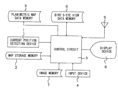
Fig. 1 is a block diagram of a map display apparatus for a
motor vehicle according to the first embodiment of the present
invention.
Fig. 2 is a flow chart showing a main routine implemented by
a control circuit of the first embodiment.
Fig. 3 is a detailed flow chart of a map display routine of
step S5 of Fig. 2.
Fig. 4 is a detailed flow chart of a bird's-eye view display
routine of step 5102 of Fig. 3.
Fig. 5 is a detailed flow chart of a planimetric map display
routine of step S103 of Fig. 3.
Fig. 6 is a view showing an example in which a bird' s-eye
view is displayed in a base screen 'while a planimetric map is
displayed in a window screen.
Fig. 7 is a view explaining a manner of calculating a
display direction angle a.
Fig. 8 is a view explaining data conversion into bird's-eye
view data.
Fig. 9 is an enlarged view showing a rectangle "abcd" of
Fig. 8.
Fig. 10 is a detailed flow chart of step S104 of Fig. 3 used
in the second embodiment.
Fig. 11 is a view explaining details of the processing of
2180937
-6-
step 5401 of Fig. 10.
Fig. 12 is a view showing the data structure of guidance
point information stored in a map storage memory.
Fig. 13 is a flow chart showing a map display routine of the
third embodiment.
Fig. 14 is a view showing an example in which a display
screen is divided into two screen regions, and a bird's-eye view
and a planimetric map are concurrently displayed in these
screen regions.
Fig. 15 is a flow chart showing a main routine implemented
by a control circuit of the fourth embodiment.
Fig. 16 is a view showing an example in which a display area
frame is displayed in a window screen.
Figs . 17A and 17B are views explaining details of a method
of displaying the display area frame.
Figs. 18A-18C are views explaining scrolling of the display
area frame in the window screen.
Fig. 19 is a detailed flow chart of a map display routine of
step S5 of Fig. 15.
Fig. 20 is a view showing an example in which a planimetric
map is displayed in the base screen while a bird ~ s-eye view is
displayed in the window screen.
Fig. 21 is a modified example of Fig. 16 in which the
display position of the window screen is changed.
w- ~ ~ ~ a 9 ~ ,,,
_, _
Best Mode for Embodying the Invention
- First Embodiment -
Fig. 1 is a block diagram of a map display apparatus for a
motor vehicle according to the first embodiment of the present
invention.
In Fig. 1, reference numeral 1 denotes a current position
detecting device for detecting the current position of the
vehicle, which consists of a direction sensor for detecting a
travelling direction of the vehicle, a vehicle speed sensor for
detecting a vehicle speed, a GPS sensor for detecting GPS
signals received from a GPS (Global Positioning System)
satellite, and others . Reference numeral 2 denotes a map
storage memory for storing road map data, which is constituted
by a mass storage medium, such as CD-ROM. The road map data
stored in the map storage memory 2 consist mainly of road data,
name data, background data and the like.
Reference numeral 3 denotes a control circuit for
controlling the whole apparatus, which consists of a
microprocessor and its peripheral circuits . Reference numeral
4 denotes an input device for entering the destination of the
vehicle and others, and 5 denotes a planimetric map data memory
that stores road map data used for displaying a planimetric map
( road map on a constant scale ) obtained by viewing a road map
from right above on a display device 8. Reference numeral 6
denotes a bird ~ s-eye view data memory that stores road map data
218a9~1
_8_
used for displaying a bird' s-eye view, and 7 denotes an image
memory that stores image data representative of images to be
displayed on the display device 8. The image data stored in the
image memory 7 are retrieved when needed, and displayed on the
display device 8. Reference numeral 9 denotes an antenna for
receiving traffic information transmitted from a beacon
receiver, for example.
Fig. 2 is a flow chart showing a main routine of the control
circuit 3 of the first embodiment. In the following, the
operation of the present embodiment will be explained referring
to this flow chart. The control unit 3 initiates the routine of
Fig. 2 when a key is operated to turn on an ignition switch, for
example. In step S1 of Fig. 2, recommended route and
destination are determined or established. Described in more
detail, the destination is determined on the basis of
information entered through the input device 4, and the
recommended route is determined by calculating according to a
known Dykstra method, for example. The recommended route may be
selected from a number of proposed recommended routes that are
stored in advance in ROM or the like.
In step S2, a display screen mode is established. The
display screen mode may be selected from eight modes ( 1 ) through
( 8 ) as described below, for example. The operator selects one
or more of these modes by means of the input device 4. In the
following description, a base screen means the whole displa~r
2180937
-9-
screen of the display device 8, while a window screen means a
part of the base screen in the form of a window in which certain
images are to be displayed.
( 1 ) A mode wherein the window screen is always displayed.
( 2 ) A mode wherein the window screen is not displayed all
the time.
( 3 ) A mode wherein the window screen is automatically
displayed as the vehicle approaches a given guidance point on
the recommended route .
( 4 ) A mode wherein the window screen is automatically
displayed upon receiving traffic/guidance information.
( 5 )A mode for displaying a bird' s-eye view in the base
screen and a planimetric map in the window screen.
( 6 ) A mode for displaying the bird' s-eye view in the base
screen and the bird' s-eye view in the window screen.
( 7 )A mode for displaying the planimetric map in the base
screen and the bird's-eye view in the window screen.
( 8 ) A mode for displaying the planimetric map in the base
screen and the planimetric map in the window screen.
Step S3 is then executed to establish display environments.
The display environments set in this step may include five items
as indicated below. These display environments are selected by
the operator through the input device 4.
( 1 ) Selecting the size of the window screen.
( 2 ) Selecting scales of maps displayed in the base screen
2184937
-10-
and the window screen.
(3) Selecting the display position of the window screen.
( 4 ) Selecting display colors of the base screen and the
window screen.
( 5 ) Selecting display directions of the base screen and the
window screen.
In step S4, the current position of the vehicle is detected.
Step S5 is then executed to implement a map display routine as
shown in detail in Figs . 3 through 5 . With this routine
implemented, a road map as shown in Fig. 6 may be displayed in
which a bird' s-eye view is displayed in the base screen, and a
planimetric map is displayed in the window screen, for example.
In step S6, the current position of the vehicle is detected
in the same manner as in step S4. Step 7 is then executed to
determine whether the road map on the screen should be updated
or not, namely, whether the road map should be rewritten or not.
In this step, it is determined to update the road map when the
vehicle runs a predetermined distance or farther, or when the
operator enters a command for scrolling by means of the input
device 4, for example.
If an affirmative decision is obtained in step S7, the
control flow returns to step S5. If a negative decision is
obtained in step S7, step S8 is then implemented to determine
whether the main routine of Fig. 2 is continued or not. A
negative decision is obtained in step S8 when a power switch
2i~~937
-11-
( not shown ) is turned off , or when a switch is operated to
cancel the routine, and the main routine of Fig. 2 is
terminated.
If an affirmative decision is obtained in step S8, the
control flow goes to step S9 to update appended information to
be displayed, and then returns to step S6. The appended
information mentioned herein may include a vehicle position
mark displayed at a position corresponding to the current
position of the vehicle, for example. In the above step S9, the
display position of the appended information, such as the
vehicle position mark, is changed according to the travel
distance of the vehicle. In the case where such vehicle
position marks are displayed on both the base screen and the
window screen, the display positions of both of the vehicle
position marks will be changed.
Figs . 3 through 5 are detailed flow charts of the map
display routine of step S5 of Fig. 2. In step S101 of Fig. 3, it
is determined whether the road map to be displayed in the base
screen is in the form of the bird' s-eye view or not . This
determination is made on the basis of the display screen mode
established in step S2 of Fig. 2. If an affirmative decision is
obtained in step 5101, step S102 is then executed to effect a
bird's-eye view display routine as shown in detail in Fig. 4, so
that the bird' s-eye view is displayed in a base screen region on
the screen.
-12-
If a negative decision is obtained in step S101, on the
other hand, the control flow of control circuit 3 goes to step
S103 to implement a planimetric map display routine as shown in
detail in Fig. 5, so that the planimetric map is displayed in
the base screen region on the screen.
Upon completion of the routine of step 5102 or 5103, step
5104 is then executed to determine whether the window screen is
displayed or not. This determination is also made on the basis
of the display screen mode established in step S3 of Fig. 2.
If an affirmative decision is obtained in step S104, the
control flow goes to step S105 to determine the road map to be
displayed on the window screen is in the form of the bird' s-eye
view or not. This determination is also made on the basis of
the display screen mode established in step S2 of Fig. 2. If an
affirmative decision is obtained in step S105, step S106 is then
executed to implement the bird's-eye view display routine as
shown in detail in Fig. 4 so as to display the bird's-eye view
in the window screen. If a negative decision is obtained in
step S105, on the other hand, step S107 is then executed to
implement the planimetric view display routine as shown in
detail in Fig. 5 so as to display the planimetric view in the
window screen.
When the routine of step S106 or S107 is terminated, or when
a negative decision is obtained in step S104, the control flow
goes to step S108 to display the appended information, such as
i
-13-
the vehicle position mark, in both of the base screen and the
window screen, and then returns to the main routine.
Fig. 4 is a detailed flow chart of the bird' s-eye view
display routine of step 5102 or step S106 of Fig. 3. In step
S201 of Fig. 4, a display direction angle used for display of
the bird's-eye view is calculated.
Fig. 7 is a view explaining a method for calculating the
display direction angle a. The XY axes shown in the figure
define a road map plane in which the origin O represents the
departure point of the vehicle, and the coordinates G (X0, YO)
represent the current position of the vehicle, while the
coordinates Pl (X1, Y1) represent the destination.
As shown in the figure, the display direction angle a is an
angle formed by a segment ( indicated by a dotted line in the
figure) connecting the current position G and the destination
P1, and the X axis, and is represented by the equation ( 1 ) .
tans = ~(Y1 - YO)/(X1 - XO)} ~ ~ ~ (1)
In the above-described step S201, the display direction
angle a is obtained according to the equation ( 1 ) .
In step 5202, the road map data around the current position
is retrieved from the map storage memory 2 on the basis of the
current position detected in step S4 of Fig. 2, and the display
direction angle a calculated in step S201. For example, the
road map data is retrieved with respect to an area within a
several tens of kilometers square including the current
-14-
position.
In step S203, data used for displaying the bird's-eye view
are selected from the road map data retrieved in step S202, and
the selected data are stored in the bird' s-eye view data memory
6. To reduce the amount of data of road map information to be
displayed on the display device 8, only data of such kinds that
satisfy predetermined requirements are selected and stored in
the bird's-eye view data memory 6. In step 5204, the road map
data selected in step 5203 are converted into bird's-eye view
data.
Fig. 8 is a view for explaining the conversion into the
bird' s-eye view data, in which an example is shown wherein a
road map extends in the XY plane, and a view point M is placed on
the Z axis that meets at right angles with the XY plane, so as to
look down the map at an angle of ~:~ The rectangle "abcd" of Fig.
8, which is shown in enlargement in Fig. 9, indicates the size
of the display screen of the display device 6, and the trapezoid
"ABCD" of Fig. 8 indicates a range of the road map to be
displayed on the display device 8.
To convert the road map data into the bird's-eye view data,
the height Z of the view point M, the looking-down angle ~ by
which the road map is looked down from the view point M, and the
looking-around angle 8 from the view point are determined so
that all of the road map data within the trapezoidal region
"ABCD" shown in the figure are displayed on the display device
2184937
-15-
6 . Thereafter, the bird' s-eye view data to be projected in the
rectangular region "abcd" of Fig. 8 are prepared using these
parameters. In this conversion processing, the looking-down
angle ~ is determined so that the destination lies in a
direction approximate to a center line connecting respective
middle points of the upper and lower edges of the display screen
of the display device 6.
Referring back to Fig. 4, step S205 is executed to convert
the bird' s-eye view data obtained in step S204 into map image
data for displaying final images on the display device 8, and
returns to map display routine.
Fig. 5 is a detailed flow chart of the planimetric map
display routine of step 5103 or S107 of Fig. 3. In step S301 of
Fig. 5, the road map around the current position of the vehicle
is retrieved from the map storage 'memory 2. In step 5302, data
used for planimetric map indication are selected from the road
map data retrieved in step S301, and the selected data are
stored as planimetric map data in the planimetric map data
memory 5, and returns to map display routine. In this step,
data sorted in a relatively high rank of priority are selected
in the same manner as in step 5203 of Fig. 4. In step S303, the
planimetric map data stored in the planimetric map data memory 5
are converted into map image data, which is then stored in the
image memory 7, and the control flow returns to the map display
routine.
-16-
The routines of Figs . 2 through 5 as explained above will be
described in short. Initially, the control circuit 3
determines the destination of the vehicle and the recommended
route, and then establishes the screen display mode and the
display environments . In the case where the mode for displaying
the bird' s-eye view in the base screen and the planimetric map
in the window screen is selected, for example, the bird' s-eye
view is first displayed in the base screen, and the planimetric
map is then displayed in the window screen. The map scale,
display area and display position of the window screen are
established by the operator through the input device 4. When
the vehicle runs a predetermined distance or farther, the whole
images in the base screen and window screen are updated or
rewritten. When the vehicle runs less than the predetermined
distance, only the vehicle position marks in the base screen and
the window screen are shifted to appropriate positions .
Thus, in the first embodiment, the road map can be displayed
in different map forms on the base screen and the window screen.
For example, the bird' s-eye view can be displayed in the base
screen, and the planimetric map can be displayed in the window
screen. In this case, the planimetric map display in the window
screen can make up for a shortcoming of the bird' s-eye view
indication, namely, a difficulty in grasping a sense of
distance.
Further, in the above-described first embodiment, the map
2~809r7
-17-
storage memory 2 as a common map data base is used for
displaying either of the bird' s-eye view and the planimetric
map on the display device 8. Thus, there is no need to provide a
map storage memory exclusively used for preparing the bird's-
eye view data, and another map storage memory exclusively used
for preparing the planimetric map data . This leads to reduced
cost and reduced size of the apparatus .
Moreover, the road map data used for display on the display
device 8 are stored in advance in the bird' s-eye view data
memory 6 and the planimetric map data memory 4. Therefore, the
display may be rapidly switched from the bird' s-eye view to the
planimetric map and vice versa.
- Second Embodiment -
In the second embodiment, the window screen is not normally
~ provided, but displayed only when~the vehicle approaches a
certain guidance point.
The second embodiment has a structure in common with that of
the first embodiment, and operates in the same manner as the
first embodiment except the processing of step 5104 of Fig. 3.
In the following, the processing of step 5104 of Fig. 3 will be
mainly explained.
Fig. 10 is a detailed flow chart of step 5104 of Fig. 3 that
is employed in the second embodiment. In step S401 of Fig. 10,
guidance points located in the vicinity of the current position
of the vehicle are retrieved from the map storage memory 2. The
2180931
-18-
guidance point mentioned herein means a point on a recommended
route, which is needed for guiding the operator along the
recommended route, and consists of an intersection or a point of
a curve, for example. The information related to the guidance
points on the recommended route is stored in advance in the map
storage memory 2.
Fig. 11 is a view explaining in detail the processing of
step S401 of Fig. 10. A plurality of square regions as shown in
Fig. 11 are retrieval units (these units will be hereinafter
called mesh codes ) of the road map data, and a specific number
is assigned to each of these mesh codes . A solid line in the
figure indicates the recommended route, and black dots on the
recommended route indicate the guidance points . Further, a
triangular mark in the figure indicates the current position of
the vehicle.
When the vehicle is located in a region having the mesh code
5339 as shown in Fig. 11, the guidance point information with
respect to each of hatched regions in the figure with four mesh
codes 5339, 5340, 5439 and 5440 surrounding the above region is
retrieved from the map storage memory 2.
Fig. 12 is a view showing the data structure of the guidance
point information stored in the map storage memory 2. As shown
in this figure, the guidance point information is divided into
several regions including: a "mesh number" region storing a
mesh code number, a "guidance point number" region storing the
2 ~ X09.
-19-
number n of the guidance point ( s ) within the mesh region, an "X-
coordinate" region storing the X-coordinate on the map of the
guidance point 1 in the mesh region, a "Y-coordinate" region
storing the Y- coordinate on the map of the guidance point 1 in
the mesh region, a "guidance point designation flag" region for
determining whether the guidance point 1 is to be selected as a
guidance point or not, and other regions .
Referring back to Fig. 10, step S402 is executed to select a
guidance point which is closest to the current position of the
vehicle, from the guidance points retrieved in step 5401. In
the case of Fig. 11, the guidance point K is selected. In step
S403, the current position of the vehicle is detected again. In
step S404, the distance L between the guidance point K and the
current position of the vehicle is calculated. In step 5405, it
is determined whether the distance L is equal to or less than a
predetermined distance. If an affirmative decision is obtained
in this step, the control flow goes to step S105 of Fig. 3 to
effect the processing for displaying the window screen. If a
negative decision is obtained in step 5405, on the other hand,
the control flow goes to step 5108 of Fig. 3 to merely update or
rewrite the appended information, such as the vehicle position
mark, in the window screen.
As explained above, the apparatus of the second embodiment
carries out route guidance without displaying the window screen
until the vehicle approaches the relevant guidance point. Once
2180931
-20-
the vehicle approaches the guidance point, the window screen is
automatically displayed, thus informing the driver of closeness
of the guidance point by displaying the window screen.
Accordingly, the driver is prevented from passing the guidance
point without noticing that the vehicle has approached the
guidance point. Further, the vicinity of the guidance point can
be displayed in detail in the window screen, thereby enabling
the driver to correctly grasp the travelling direction of the
vehicle.
- Third Embodiment -
In the third embodiment, the display screen of the display
device is divided into two screen regions, and a bird' s-eye view
is displayed in one of the screen regions while a planimetric
map is displayed in the other screen region. The third
embodiment is different from the first embodiment only in
respect of the map display routine to be implemented by the
control circuit 3. In the following description, therefore,
the map display routine will be mainly explained.
Fig. 13 is a flow chart showing the map display routine of
the third embodiment. In step 5451 of Fig. 13, it is determined
whether divided screens are to be displayed or not . In this
step, the determination is made on the basis of the display
screen mode selected by the operator by means of the input
device 4. A mode for displaying the divided screens is
included.
'.,..
-21-
In step S452, it is determined whether the bird's-eye view
is displayed in the left-hand screen region of the display
screen. In this step, the determination is made on the basis of
the display environments established by the operator by means
of the input device 4. If an affirmative decision is obtained
in step S452, the control flow goes to step 5453 to implement
the bird's-eye view display routine as shown in detail in Fig.
4. If a negative decision is obtained in step 5452, on the
other hand, the control flow goes to step 5454 to implement the
planimetric map display routine as shown in detail in Fig. 5.
Upon completion of the routine of step 5453 or S454, step
S455 is then executed to determine whether the bird' s-eye view
is displayed in the right-hand screen region of the display
screen. If an affirmative decision is obtained in step S455,
the control flow goes to step S456~to implement the bird's-eye
view display routine as shown in detail in Fig. 4. If a
negative decision is obtained in step S455, on the other hand,
the control flow goes to step S457 to implement the planimetric
map display routine as shown in detail in Fig. 5. Upon
completion of the routine of step 5456 or S457, step S458 is
then executed to effect the processing for displaying appended
information, such as vehicle position marks.
As a result of the above-described routine, the bird' s-eye
view and planimetric map may be displayed in different screen
regions at the same time, as shown in Fig. 14. In the example of
2180937
-22-
Fig . 14 , the bird' s-eye view is displayed in the right-hand
screen region, and the planimetric map is displayed in the left-
hand screen region. In this example, a part ( in the vicinity of
the vehicle position) of a range of the road map displayed in
the form of the bird' s-eye view is displayed in the form of the
planimetric map. Therefore, a wide range of road map extending
from the vehicle position toward the destination can be
confirmed with the bird's-eye view, and a detailed road map
around the vehicle position can be confirmed with the
planimetric map.
- Fourth Embodiment -
In the fourth embodiment, a display area frame defining a
map display range of the base screen is displayed in the window
screen. Fig. 15 is a flow chart showing the main routine
implemented by the control circuit 3 of the fourth embodiment.
The flow chart of Fig. 15 is different from that of the first
embodiment as shown in Fig. 2 only in respect of steps S510 and
S511. In the following description, therefore, the processing
of steps 5510 and S511 will be mainly explained.
In step S510 of Fig. 15, it is determined whether the window
screen is displayed in the display screen . I f a negative
decision.is obtained in this step, the control flow returns to
step S506. If an affirmative decision is obtained, the control
flow goes to step 5511 to update the display area frame. In
step 5511, the display area frame is updated. The display area
2180937
-23-
frame mentioned herein means a frame defining a road map range
displayed in the base screen. As shown in Fig. 16, the display
area frame is displayed with a thick solid line within the
window screen.
Fig. 17 is a view explaining in detail a manner of
displaying the display area frame. As shown in Fig. 17, a
triangular vehicle position mark M is displayed within the
display area frame. In Fig. 17A, the coordinates of the vehicle
position mark are represented by M (X, Y) , and the coordinates
of respective points A, B, C, D of the trapezoidal region "ABCD"
indicating the display area frame are represented by A (X - 10,
Y - 20), B (X + 10, Y - 20), C (X + 40, Y + 60), and D (X - 40, Y +
60), respectively.
Fig. 17B shows an example wherein the vehicle has moved from
the position M of Fig. 17A by a distance corresponding to (AX,
~Y) . As shown in the figure, the display area frame is shifted
from the above-indicated coordinates "ABCD" to "A' B' C' D "' so
that the position of the vehicle position mark relative to the
display area frame does not change.
Fig. 18 is a view explaining scrolling of the display area
frame within the window screen. Fig. 18A is a view showing the
display area frame before movement of the vehicle, with the top
of the window screen oriented in the north direction of the map,
and Fig. 18B is a view showing the display area frame after
movement of the vehicle, with the top of the screen oriented in
2180937
-24-
the travelling direction of the vehicle. Fig. 18C is a view
showing the display area frame after movement of the vehicle,
with the top of the window screen oriented in the north
direction. In Figs. 18B and 18C, white triangular marks
represent the position of the vehicle before it moves, and black
rectangular marks represent the vehicle position after its
movement.
As shown in Figs. 18B and 18C, the vehicle position mark is
displayed at a fixed position within the display area frame
irrespective of which direction in which the vehicle moves, and
which direction in which the frame is displayed in the window
screen.
Fig. 19 is a detailed flow chart of the map display routine
of step S5 of Fig. 15. The flow chart of Fig. 19 is different
from the map display routine of the first embodiment as shown in
Fig. 13 only in respect of step S608. In the following
description, therefore, the processing of the step S608 will be
mainly explained.
In step S608 of Fig. 19, the display area frame defining the
road map range to be displayed on the base screen is displayed
within the window screen as shown in Fig. 16. Figs. 20 and 21
show examples of screen display as a result of the map display
routine of Fig. 19. Fig. 20 shows an example wherein a
planimetric map is displayed in the base screen, and a bird' s-
eye view is displayed in the window screen. Fig. 21 is a
'' 2 ~ 89:37
-25-
modified example of Fig. 16 in which the display position of the
window screen is changed. The change of the display position of
the window screen is effected by implementing the above-
described processing of step S3 of Fig. 2.
In the fourth embodiment as described above, the display
area frame defining the road map range displayed in the base
screen is displayed in the window screen, thereby allowing the
operator to grasp at a glance the road map range displayed in
the base screen. Even when the vehicle runs through a region
that is unfamiliar to the operator or driver, therefore, the
driver can easily understand the positional relationship
between the current position and the destination, with a result
of reduced possibility of getting lost. If the planimetric map
is displayed in the window screen while the bird' s-eye view is
displayed in the base screen, the 'shortcoming of the bird' s-eye
view indication, namely, the difficulty in grasping a sense of
distance can be overcome due to the presence of the planimetric
map in the window screen.
In the examples of Figs. 16, 20 and 21, the entire range of
the road map displayed in the base screen is displayed in the
window screen. Depending upon the map scale selected by the
operator, however, the entire road map range displayed in the
base screen may not be displayed in the window screen. In such
a case, a warning to this effect may be displayed in the window
screen, or only a part of the display area frame may be
218Q~~7
-26-
displayed. Otherwise, the map scale in the window screen may be
automatically determined so that the entire range of the road
map displayed in the base screen can be displayed in the window
screen.
While the display position of the window screen may be
changed in response to a command entered by the operator in the
above-described fourth embodiment, the window screen may be
automatically provided in an area that does not overlap the
vehicle position mark or the recommended route. That is, the
display position, display area and other conditions of the
window screen may be automatically established.
In the illustrated embodiments, there may be provided a
switch or switches for scrolling the base screen and the window
screen independently of each other. When the switch for
scrolling the window screen is operated, for example, the road
map in the screen is scrolled in response to the operation, and
the display area frame and the vehicle position mark may also be
shifted at the same time.
While the display screen mode and display environments are
established in the main routine of Fig. 2 executed by the
control circuit 3 in the illustrated embodiments, interruption
routines may be employed for establishing the display screen
mode and display environments. Namely, if the operator enters a
command through the input device for changing any one of the
display screen mode and display environments, the processing of
~." 2 ~ ~~~~~
-27-
the control circuit 3 is interrupted so as to make a desired
change in the display screen mode and others . In this manner,
the mode and others can be rapidly changed as desired.
While the display area frame is displayed in the window
screen in the above-described fourth embodiment, the range of
the road map displayed in the base screen may be displayed with
different colors, instead of the display area frame.
Availability in the Industry
As described above, the .map display apparatus for a motor
vehicle according to the present invention is capable of
switching its display from a planimetric map to a bird' s-eye
view and vice versa, thus permitting the road map to be
displayed with increased flexibility to meet with the
convenience and preference of the driver. Since road map
storage means serving as a common map data base is used for
display of either of the planimetric map and bird' s-eye view,
there is no need to provide separate map data bases for these
two forms of display, resulting in reduced cost and reduced size
of the apparatus . Further, the planimetric map and the bird' s-
eye view can be displayed at the same time, thus eliminating a
problem encountered in bird's-eye view indication, namely, a
difficulty in grasping a sense of distance. Moreover, an
indication defining a range of the road map displayed in the
21 80937
-28-
first display region in the display screen of the display device
can be displayed in the second display region, thereby allowing
the driver or operator to grasp at a glance the road map range
displayed in the f first -display region, and enhance a sense of
distance.