Note: Descriptions are shown in the official language in which they were submitted.
CA 02181457 2005-O1-25
64159-1470
-1-
TERRAIN ELEVATION PATH MANAGER
BACKGROUND OF THE INVENTION
The present iuveation relates generally to terrain following aircxaft control,
and
more particularly to a method for accessiag~and utilizing ten~ain elevation
data in the
context of terrain following flight.
To minimize above ground elevation, and therefore urinimize visibility sad
1o winerability to ground based detection and attack, military aircraft often
execute
terzain following flight. 'Terrain following flight generally maintains a
gives elevation
above ground level independent of actual elevation above sea level. In other
words,
the aircraft follows the ground contour at a subataatially faced elevation
above the
Bound and maneuvers according to prevailing ground contour along a gives
flight
Bath. The actual above ground level elevation may increase to establish a
suitable
climb angle to char an upcoming high elevation Terrain feature.
The gcnerai algorithm applied to flight foiloaiing terrain is to select the
tallest
terrain feature lying along and near the flight path. The aircraft altitude
and attitude
vector are referenced to determine whether or not an upcoming terrain feature
will be
Z 0 cleared. If necessary, the terrain following algorithm requires that the
aircraft eater a
suitable climb angle to clear any upcoming terrain features. Otherwise, the
algorithm
would maintain a substantially consistrent above grownd elevation according do
a given
terrain profile data structure.
A,s used herein, the term "terra'sn profile" shall refer to a data struuure
representing terrain along a given flight path. A terrain following algorithm
uses the
terrain profile data struc4rne to execute terrain following flight slung the
designated
flight path. A terrain proFile may be tlwught of generally as a terrain cfosa-
sectioaat,
elevational contour, e.g., as taken through a vertical plane containing the
flight path,
but must account for terrain conditions near the designated Might path. For
examples
3 0 for a given point along the flight path, the highest elevation point
laterauy outward on
either side a given distance is assigned as the terrain proFle elevation at
the gives
point. This produces a conservative, i.e., safe, elevation contour in the
terrain profile.
X181457
Most terrain follov~~ing applications use radar and/or radar sensor data to
generate a terrain profile along a predicted flight path of the airczaft. The
predicted
flight path is generally based on the current aircraft attitude and velocity.
Terrain
following flight is preferably executed, however, with limited or no active
sensor data
because aciive sensor emissions make the aircraft visible to threat
installations at
greater dis'~ances. Using active sensors, especially at high oawer,
com,~romises covert
missions because the aircraft can be detected at long distances by hostile
forces. If
active sensors are to be used, such sensors are preferably used at low power
settings to
minimize detectable emissions and allow only short range detection by hostile
forces.
Unfortunately, terrain following fligi~t requires more distant terra.ia-
iaformation,
typically exposing the aircraft to detection if generated using long range
high power
active sensors. Furthermore, active sensor data has its limitations. Sensor
data alone
cannot see behind hills or around corners. Sensors can only "guess" where to
gather
te~ain data. in generating a terrain profile.
1S Digital terrain elevation data represents surface elevation at discrete
"data
posts." Each data post has a surface location or address, e.g. latitude and
longitude,
and an associated elevation, e.g. ;eiative to sea level. Thus, a simple form
of a DTED
database would deliver a sealer elevation datum in response to longitude and
latitude
address input, h4ore complicated DTE3~ databases have been developed far
certain
zo applications. p'or example U.S. Patent Na. 4,899,?92 issued February 6,
1990 to J. F.
Dawson and E. W. Ronish shows a tessellation method for cxeating a spherical
database by warping a digztal map, including digital terrain elevation data,
by
longitude and IatiW de parameters.
DTED database systems are used in flight mission computer systems and flight
2 5 planning strategy in military applications aid iu, for example, covert sad
evasive flight
operations. As used in mission computer systems, a DTED database can aid a
pilot in
trine-critical maneuvers such as terrain following flight or in selecting
routes ~ H,sive
with respect to a given threat position. Such threat positions may be known in
advance, or detected while is flight. The computation speed resluired in
accessing sad
3 0 calculating mutes or alternatives based on DT~D can be vitally c:itical,
especially fQr
repeated computations required to keep a pilot fully appraised of current
teixain
2181457
_;_
conditions and route al;ernatives. Thus, improvements in mettzods of accessing
DTED
and comQutatioas based on extracted DTED are not sirnpiy improvements in
computational elegance, but can be life-saving and critical to mu.ssion
success.
Terzain profiles have been built by extracting a massive volume of DTED data
with reference to a designated flight Bath. As may be appreciated, each data
sample
Liken from the DTED database far consideration is generating the terrain
profile
requires a given amount of processing time. The data extracted from the DTED
database for generating the terrain profile corresponded to data posts lying
along a
length of the fliglat path preceding aircraft position and all data posts
within a given
distance of that length portion, i.e, a fixed length and ~~idth region of data
posts along
the flight path and identified relative to current aircraft position. The
terrain profile
:nest provide safe, conservative information. To this end, a large volume of
DTED
data has been incarpozated into terrain profiles. Unfot'tunateiy, the volume
of data
extracted and processed has constrained terxain profile generation, i.e., has
required
excess terrain profile calculation time.
Thus, prior methods of generating terrain profiles include long range active
s°nsozs, but long range sensor emissions make airczaft visible at long
distances. These
prior art methods have included DT):.D database systems, but generating
conservative
terrain profiles requires massive zzumbers of DTED data points and can require
2 0 relativ ely long calculation ti me.
A relevant prior art reference is European Patent application 0 499 874, a ray-
tracing algorithm method with a digital database to process only the visible
surfaces in
a field of view. During operation to different sets of inforaiacion are
analyzed. The
first is a constant width data corridor comprising a narrow and of high
resolution data.
Second is a widex band of lower resolution data_ The focus of this invention
is the
resolution of the data in the particular corridor. ,
It is desirable, therefore, that terrain following flight be executed without
aid
of high power, long range active sensor data to avoid exposing the airc.-a~ to
threat
installations. It is fufther desirable that a method of producing a terrain
pmfile for
3 ~ executing terrain following flight support dynamic and efficient
calculation time.
SUlIr~VIARY CfF THF INV'EN"TION
CA 02181457 2005-O1-25
64159-1470
In accordance with the present invention, an aircraft flight path is selected
and
a limited volume of DTED data points ase extracted from a DTED database to
safely
minimize the above wound level elevation at any given point during the terrain
following flight. I~iore particularly, the DTED data points extracted from the
database
are takes from sample regions havimg dimension according to conditions such as
time
sad distance relative to the aircraft.
In accordance with a preferred embodiment of the present invention, each
sample region is centered upon the selected flight path and positioned
relative to the
aircraft, but varies in width relative to other sample regions. Cmaerally, the
wider
1o sample regions are near the aircraft, and sample regions more distaatfrom
the aircraft
along the selected flight path become increasing more narrow. The widest
sample
region corresponds to a portion of the flight path, at a given position
relative to the
aircraft, associated with potential aircraft flight path deviation. . Thus,
additional
terrain data is considered in the event of such unexpected deviation from the
terrain
i5 following flight path. In this manner, a relatively greater volume of DTED
data is
extracted as needed. More distant terrain along the flight path is suitably
evaluated,
but using a lesser volume of DTED data. As a result, computational throughput
and
memory requirements for terrain following flight algorithms are minimized
while
maximizing terrain fallowi.ag performance and safety criteria.
2 o The raethod of generating a terrain profile is particularly pointed out
and
distinctly claimed in the concluding portion of this specification. However,
both the
organization and method of operation of the invention, together with further
advantages and objects thereof, may best be understood by reference to the
following
ddcription taken with the accompanying drawings wherein like reference
characters
2 5 refer to like elements.
CA 02181457 2005-O1-25
64159-1470
-4a-
In accordance with one aspect of this invention,
there is provided a method of generating a terrain profile
on an aircraft's flight mission computer system using a
sample region of digital terrain elevation data which
corresponds to an aircraft's position and predicted flight
path, the method comprising the steps: identifying a
plurality of sample regions located directly under and along
the predicted flight path of the aircraft, said sample
regions varying in dimension according to use criteria
including possible short range terrain following commands,
potential flight path deviations, and long range terrain
following commands, said plurality of sample regions
include, said sample regions being updated as the aircraft
progresses along the flight path; and transforming said
plurality of sample regions into a terrain profile, wherein
a first sample region is dimensioned according to short
range terrain following flight command data needed, a second
sample region is dimensioned according to potential flight
path deviation data needed, and a third sample region is
dimensioned according to long range terrain following flight
data needed; the first sample region being an intermediate
volume and closest to the aircraft, the second sample region
being a greatest volume and next closest to the aircraft,
and the third sample region being a least volume and most
distant from the aircraft; and transforming data posts of
said first, second, and third sample regions into a terrain
profile.
In accordance with another aspect of this
invention, there is provided a method of generating a
terrain profile on an aircraft's flight mission computer
system using a sample region of digital terrain elevation
data which corresponds to the aircraft's position and
predicted flight path, the method comprising the steps:
CA 02181457 2005-O1-25
64159-1470
-4b-
identifying a plurality of sample regions located directly
under and along the predicted flight path of the aircraft,
said sample regions varying in dimension according to use
criteria including possible short range terrain following
commands, potential flight path deviations, and long range
terrain following commands; and transforming said plurality
of sample regions into a terrain profile, wherein said
plurality of sample regions include: a first sample region
having length and width dimensions chosen as a function of
data required for execution of terrain following flight
commands for terrain in a vicinity of the aircraft; a second
sample region located directly under and along said flight
path and in advance of said first sample region relative to
said aircraft position, said second sample region having
length and width dimension which are directly related to
potential flight path deviations caused by unexpected
events; a third sample region with a length and width
determined from data required in returning to said flight
path from one of said potential flight path deviating
conditions; and a fourth sample region located furthest from
said aircraft in relation to said first, second, and third
sample regions, said fourth sample region having a minimum
width dimension relative to the width dimensions of said
first, second and third sample regions.
BRIEF DESCRIPTION OF THE DRAWINGS
For a better understanding of the invention, and
to show how the same may be carried into effect, reference
will now be made, by way of example, to the accompanying
drawings in which:
2181457
-5.
FIG. 1 illustrates in plan. view a sample region taken from a DTED database in
accordance with the present invention foc generating a terrain profile to aid
in terrain
following flight.
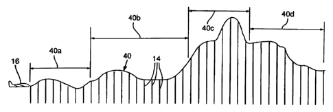
FIG. 2 illustrates a terrain profile generated frorn the sample reF.~'on of
FIG 1.
DET,r'IIi.ED l?ESCRIPTIOlV OF TTr~ PREFERRED EMBODIMENT
FIG. 1 illustrates a flight Bath 10 with reference to a portion of a digital
terrain
elevation data (I7'f'ED~ database i2 comprising a grid of data posts 14. Each
data post
I~ is indicated in FIG. 1 as an "X", but no scale in data post 14 spacing is
indicated
nor is every data post 14 shown, DTED database 12 may take a variety of
formats,
but as relevant to the present invention may be taken generally as an X"Y
addressable
array of data posts 1~, e.g., addressed by latitude and longitude, and
providing
elevation at a given location. The flight path 12 may be a flight path
selected as part
of a mission plan, or may be a flight path predicted dynamically as a function
of the
current aircraft attitude and velocity vectors. In either case, it is
necessary to extract
from the DTED database 12 elevation data xelaiive to flight path 10 to
generate a
terrain proftte in aid of terrain following flight tbesealoag.
Terrain following flight is executed in accordance with the present invention
2p by reference to the DTED database 1~ with little or no additio~aal active
sensor data.
Any active sensors used would be at low power and detectable only within
several
nautical miles of the air~aft. It is desirable to cxecate such terrain
following flight
with a minimum above ground level elevation to minimize the aircra~ visibility
arid
vulnerability to attack from threat installations. Using a terrain profile
based on
DTED information, the aircraft can achieve such minimum above ground Level
elevation by anricigating upcoming terrain conditions and minimizing above
ground
level elevation with resQect tv such anticipated terrain conditions taking
into account
aircraft and pilot flight capabilities and reaction times.
As may be aQpreciated, a DTED database can be huge and cornputationaily
burdensome to analyze in its entirety, especially while dynamically executing
terrain
following flight. In accordance with the present inv ention, izowever, only a
limited
2~ao5~
portion of database 12 need be extracted, i.e., sample zegion 18, for use in
generating a
terrain profile for executing terrain following flight. This minimizes the
computation
and memory requirements of such terrain following fligb~t. The sample. region
18
includes a set of subrerions 18a-18d each selected dynamically as a function
of
aircraft 16 position along fight path 10.
A short-term profile subregiorl 18a exists along flight path 10 beginning at
and
e:rtending approximately 2 nautical miles in front of aircraft 16. 'the width
of short-
term profile subregion 18a may vary while in flight as a function of aircraft
NAV
CEP, cross track deviation, and aircraft 16 wingspan This restricts fine
adjustments
l o of the terrain profile obtained to the xegion of database 12 from which
most terrain
following steering commands are most likely generated, i.e., the horizon,to
clear is
typicahy within 2 nautical males of the aircraft 16.
A first m.id-terra. profile subregion 18b, beginning at approximately 2
nautical
miles in front of aircraft i6 along flight path 10 and terminating at
approximately 5
nautical miles from aircraft 16, is relatively wider than that of short-term
subregion
I Sa. The width of mid-term subregion 18b may be a coBStant width, bat defined
as a
function of potential forces or conditions acting to drive the aircraft 16 off
the selected
or predicted flight path 10, Thus, to the extent that aircraft i6 may deviate
from path
10, region 18b should be suitably wide enough to anticipate flight within this
range of
2 Q potential deviation. The type of forces considered in establishing a width
for mid-
term subregion 18b can be generally characterized as unpredicted conditions.
Fur
example, a sudden, unexpected sidewind may drive the aircraft off the flight
path I0,
or an unforeseen event may distrac~ the pilot and the aircraft might deviate
to some
r
extent relative to flight path 10. Thus, in establishing the width of niid-
term subregion
18b, a variety of potential path deviating conditions may be considered. Also;
the
width calculation should tale into account specific information such as pilot
resQonse
dme to ungredicted events and the specific aircraft used, i.e., aircraft
response to pilot
commands, For example, a fast aircraft having relatively slow ground track
response
may require a relatively wider subregion 18b due to the relatively greater
distance the
aircraft could potentially deviate from flight path 10 due to its speed and
relatively
CA 02181457 2005-O1-25
64159-1470
_?_
slow ground track respansc. Ia contrast, a slow, large aircraft may have fast
ground
track response and permit a relatively more narrow subregion 18b.
A second mid-term subrcgion 18c, beginning at approximately 5 nautical miles
along flight path from aircraft 16 and terminating at approximately T nautical
miles
along flight path 10 relative to aircraft l6, is relatively more narrow than
that of
subregion 18b. It is assumed that the pilot will steer back onto path 10 is
response to
any path deviating forces detected in region 20 and thereby have the advantage
of
early consideration of the subregion 18c. A length and width of subregion 18c
are
determined from data required in returning the flight path from one of the
potential
flight path deviating conditions.
A long-term profile subregion 18d, beginning approximately 7 nautical miles
along flight path 10 relative to aircraft 16 to approximately 20 nautical
miles along
flight path 10 relative to aircraft 16, is the most narrow portion of region
18. The
width of subregion 18d may be a single data post 14 such that major terrain
variation
directly along path 10 may be considered well in advance.
FIG. 2 illustrates a terrain profile 40 generated from region 18. Profile
section
40a corresponds to flight path 10 within subregioa 18a, section 40b within
subregioa
186, section 40c within subrcgion 18c, and section 40d within subregioa 18d.
The
method of transforming sample region 18 into terrain profile 40 may take a
variety of
Z D forms. Under any such method of conver'ang sample region 18 into terrain
profile 40,
however, it is assumed that the computational time and resources required are
a
function of the number of data posts considered. Thus, because the method of
analysis
under the present invention allows generation of as acceptable , i.e., safe or
coaqervative, terrain profile based on a relatively smaller volume of DTED
data, the
method of the present invention o$'ers an advantage in lesser computational
time and
resource requirem~ts while maintaining strict safety criteria.
Under the present invention, tile volume of DTED database 12 data gathered
and analyzed is minimized according to its use. The subregion 18a accounts for
that
portion of database I2 necessary for executing most terrain following
eomcr~aads.
3 0 Processing of database 12 is thereby minimized by e~ctracting data
relevant to most
terrain following flight commands. The subregion 18b is larger in volume, but
must
be considered in generating terrain profile 40 in the event of unexpected
flight path 10
2181457
$_
deviation. A relatively smaller voluuze of database 12, i.e.. subregions 18c
and 13d, is
availahie to anticipate conditions more distant from aircraft 16.
as aircraft l 6 moves along flight path 10 the sample region 18 defines which
portions of database 12 are reviewed or sauipled for analysis. The subregions
1Sa-18d
thereby change dynamically with respect to database 12 as aircraft 16 moves
forNard
along flight path 10. Thus, at any given time aircraft 16 has available the
sample
region 18 for analysis is generating terrain profile 40 and executing flight
terrain.
Following maneuvers.
A, Variety of methods of extracting DTE'D data conforming to sample region 18
may be ernpioyed undex the present invention. It is eontetnplated that the
extraction of
sample region 18 relative to flight path 10 and aircraft 16 be by software.
implementation. Qnce the overall dimension criteria far sample region ? 8 is
~tabLished, it is considered within tire ordinary skill of one in relevant art
to extract
the sample region 18 an;d ge~aerate a terrain profile 40 according to a sriven
terrain
profile transformation algorittun, i.e. convert sample region 18 into terrain
profile 40.
By limiting the volume of information extracted from and analyzed under
texrain following flight algorithms, the presemt invention makes terrain
foiiewiag
flight more efficient and accurate by considering only those terrain fearsrss
relevant to
the curxent flight path and potential deviations therefrom. extraneous
portions of
DT~D database 12 are not extracted and not analyzed. Ac:.ordiztgly, overall
computational throughput and memory requirements for the terrain following
f~.i~t
algorithm are suostantiall,~ reduced in accordance with the present invention
without
compromising the integrity of the terrain following flight al?orithm.
'phe method of the present invention caz~templates generation of a terrain
profile which may be used alone, or integrated with short range active sensor
data.
When used in caz~junction with active sensor data, the active sensors need
only
be operated at low power settings. As a result, aircraft is visible to hostile
forces only
within several nautical miles of aircraft position. In this coordinated use,
the terrain
profile 40 simulates a long range sensor capability for anticipating terrain
conditions
3 0 , and dictet'tng long range terrain following flight maneuvers.
2181457
..:.
-9-
a he active sensors contribute real terrain condition data serving as a short
range sensor in the inzmesli.ate vicinity of the aircraft. Thus, as additional
short range
terrain profile representing the immediate proximity of the aircraft can be
based on
active sensor data.. The mere distant portions of the terrain as represented
by terrain
profile 44 are based on sample region 18.
The aircraft remains relatively hidden 'vy using low power active sensors, but
possesses the tactical advantage of considering tez~rain candirions at a
substantial
distance from the aircraft position. i~iormally, to have the benefit of such
long
distance terrain profile information, the pilot would have to operate the
active sensors
at high power and undesirably make the aircrafrt visible to hostile forces
from tong
distances. Alternatively, a tc:rain profile could be generated from a D"1">rD
database,
but such terrain profile generation has, heretofore, bern cocnnutationally
burdensome
and not well adapted for dynamic operation, i.e., during flight, due to the
volume of
data normally extracted :or such terrain profle generation. Generation of a
terrain
profile under the present ~aveation, however, is acxomplished at greater speed
and,
therefore, be more easily :ategx3ted into a dynamic in-flight terrain larofile
generating
algorithm.
The method of DTED database analysis of the present invention maximizes
safety while allowing !owcr :errain following flight. In utili~,ng a.
prepianned flight
route, the present invenucn capitalizes on a complete knowledge of the
mission.
When analyzing a predic:ed rouu based on aircraft atti*a~de and velocity
vectors, the
present in~~ention need not be limited by use of active sensor data.
Accordingly, the
rrsethod of the present invention is not liumited by a sensor field of view
and can
consider "hiddr,.n terrain", i. e.. :errain normally hidden from sensor view.
Because the
method of the present inwsltion relies prir~tarily on the DTED database 12,
all terrain
:~s visible and availa't~le ;or analysis. 3n contrast, in terrain following
systems relying
an active sensor data ce.~tain terrain is masked by terrain profile,
especially when
f)ying at low above ground elevations, and therefore unavailable for
aaticigating flight
~o.aneuvers. Thus, tine merhod of the present znventian allows lower average
elevation
3 0 because the aircraft need not travel at relatively higher altitudes to
generate a terrain
profile by use of active sensor data. The "real" terrain conditions are
represented by
2181457
_,
short range sensor equipment presenting limited risk of visibilir~ to hostile
forc$s.
Long range terrain profile information is obtained efficiently, under the
gresent
invention, from the DTED daxa base 12 and is available for complete analysis
of
upcoming terrain in anticipating terrain following flight maneuvers.
The method of generating a terrain profile under the present invention may
take into account a variety of factors including typical pilot response times
and
particular aircraft iunfotmativa such as response tinge aid flight maneuvezing
capabilities. The specific mission may be characterized by taking all such
parameters
into account in selecting the width and length of the various subregions of
sample
region 18.
The specific dimensions, including length and width for the subregions 18a-
18d are generahy mission aid aircraft specific. It is notconsidered possible
to set
Earth specific dimensions ar formula to calculate dimensions for these
subregiorss. tLs
noted above, each subregion is dimensioned according to expected use of the
data. In
L5 implementation of the present invention, actual flight data is considered
the best
method to generate dimensional values for the subregions 18a-I 8d. Such flight
darn
was obtained by logging aircraft position relative to an expected fligat Bath
and
anaiyaing this data to establish criteria for dimensioning the subregians 18a-
i8d.
For example, by analyzing an actual flight path relative to an expected flight
2o path a statistical deviation from expected flight path may be derived. This
statistical
deviation could, for example, correlate generally to the subregiva 18c and to
the
subregioa 18b. The subregioa l8b could then be made larger or smaller relative
to
this statistical deviation as a funciion of the magnitude of safety one wishes
to
incorporate into the terrain profile generating aigorithfn. If a broad
spectrum of
25 unexpected flight path deviating conditions are to be allowed, i.e., a
conservative
safety margin, the subregiotl 18b would be correspondingly larger. if,
however, the
algorithm is to accept a certain degree of risk by not allowing consideration
of a broad
range of unexpected flight deviating conditions, the subregion 18b could be
riaade
correspondingly smaller. The subregion 18d has bees found to be effective at
the least
3 0 width magnitude, i.e., a width o~ one data post 14, as a good indicator of
general
terrain conditions well is advance of aircraft 16 position.
2181457
Thus, it is suggested that actual flight data be employed to generate the
dimensional requirements for the subregions 18a-18d. 'fhe specific dimnensions
For
these sample subrcgions may be developed in conjunction with overall mission
strategy and safety factors considered. For example, if the aircraft is to
execute terrain
~oiiowing flight at extremely high speeds without use of long range active
sensor data,
the execution time requirements in generating the terrain profile may require
that a
very small volume of DT~D data be used in generating the terrain profile.
Conversely, if the aircraft is traveling at slower speeds or aircraft safety
is a larger
concern, a correspondingly larger dunensioned sample region 18 may be employed
to
meet these mission specific criteria.
Accordingly, no specific calculation or formula can be provided far general
use, but is contemplated that the present invention allow for adjustment in
the
dimensioning of the sample region 18 to meet such spcci=ic criteria, i.e., the
sample
region 18 is dimensioned according to ita expected use and mission specif c
parameters.
This invention has been described herein in considerable detail in order to
comply with the Patent Statutes and to provide those skilled in the art with
floe
information needed to apply the novel principles and to construct and use such
specialized components as are required. However, it is to be understood that
the
2o invention is n.ot restricted to the particular embodiment that has been
described and
illustrated, but can be carried out by specifically different equipment and
devices, and
that various modifications, both as to the equipment details and operating
procedures,
can be accomplished without departing from the scope o~the invention itself.
What is claimed is: