Note: Descriptions are shown in the official language in which they were submitted.
CA 02183113 2000-11-22
1 FIELD OF THE INVENTION
2 The present invention relates to an improved method for determining the
3 location and orientation of resE:rvoir boundaries from conventional well
test data.
4 More particularly, the invention refines the determination of an image of
the reservoir
boundary by individually rotating the boundary information determined for each
6 radius of investigation, and fitting it with known geologic features, the
angle-of-view
7 information being rotated about 'the well.
8
9 BACKGROUND OF THE INVENTION
'10 The present invention relates to improved methodology of well test imaging
'I 1 disclosed in U.S. Patent 5,548,563 (hereinafter "the'S63 patent").
'12 The invention provides a refined method for matching angle-of-view and
'13 radius of investigation information to known geologic features for more
precisely
'14 defining the reservoir boundary. For convenience, a brief description of
the concept
'15 of angle-of-view is summarized herein.
t
2183113
1 A conventional well test is performed on a well, establishing measures
2 of the well's pressure response as a function of the rate of pressure change
in the
3 reservoir over time. Conventional techniques are used to determine measures
of the
4 radius of investigation. The calculated response for an infinite and
radially extending
well and the measured response are compared as a ratio. Variation of the ratio
from
fi unity is indicative of the presence of a boundary and its magnitude is
related to an
7 angle-of-view. The angle-of-view is related to the extent of the effect of
the boundary
8 on the well.
9 As determination of the exact orientation of the boundary is
indeterminate, the image formed is a result of the application of one of
several
11 assumed models; the Angular Image Model, the Balanced Image Model or the
12 Channel-Form Image Model. The appropriate model to apply is that which
produces
13 the best fit with known geologic features, determined by seismic or other
data. More
14 particularly, an angle-of-view is calculated for each radius of
investigation. By
combining the angle-of-view and the radius of investigation, one can define
vectors
16 which extend from the well to locations on a boundary. The boundary
information
17 determined at each successive radius of investigation is related to
previous boundary
18 information according to the criteria defined by the model. All boundary
information
19 is combined to form an image of the reservoir boundary. The model's image
which
is most representative of the reservoir is chosen, based upon a comparison of
angle-
21 of-view values, known geologic data and/or images from other proximally
located
22 wells.
3
CA 02183113 2000-11-22
1 Application of the method disclosed in the '563 patent sometimes results in
2 less than a satisfactory match with known geologic data. Note that the
entire image
3 was formed according to a model and then aligned to fit best with the
geologic
4 information. Unfortunately, while each angle-of-view is representative of
the effect of
the boundary at that radius of investigation, it did not necessarily convey
the
6 information necessary to properly orient each angle-of-view with respect to
each
7 other angle-of-view.
8 SUMNIARY OF THE INVENTION
9 In accordance with the invention, an improved well test imaging method is
"10 provided for relating transient pressure response data of a well test to
its reservoir
'11 boundaries.
'12 The improvement sterns from an understanding that the angle-of-view
'I 3 information determined for each radius of investigation is distinct from
all others and
'14 may be individually rotated for a more precise orientation with known
geologic
'15 features.
'16 In one broad aspect then, the invention is a method for creating an image
of
'17 an oil, gas, or water reservoir boundary from well pressure test data
values, the
'18 image being oriented relative to a well located in a reservoir,
comprising:
'19 ~ obtaining reservoir pressure response values from a well pressure test
:?0 selected from the group consisting of drawdown, build-up, fall-off and
:? 1 pulse tests;
:?2 ~ providing geologic features which are known for the reservoir and have a
:?3 known orientation to the well;
4
2183113
1 - using the pressure response values obtained to calculate data values
2 reflecting the rate of pressure change over time and the radius of
3 investigation;
4 - extracting from the data values obtained in step (b) the response that is
due to near-wellbore and matrix effects, to obtain residual values
6 representative of boundary effects;
7 - calculating values from the residual values representative of an angle-of-
8 view of the boundary as a function of time;
9 - subtracting each angle-of-view from a ring, each ring being analogous
to the circumference of the corresponding radius of investigation in time,
11 to form a plurality of circumferential arcs;
12 - individually rotating each circumferential arc about the well so that at
13 least one of the end-points of the circumferential arc is substantially
14 coincident with a known geologic feature;
- determining values, by analyzing and applying the spatial location of the
16 end-points of the circumferential arcs, indicative of the location and
17 orientation of the boundaries of the reservoir and using said values to
18 form visual images showing the reservoir boundaries relative to the
19 location of the well.
5
2183113
1 In another aspect, if the circumferential arc intersects more than one
2 geologic feature, then the arc is divided at each intersection with a
boundary-forming
3 geologic feature to form a new shorter arc having a new end-point where the
arc was
4 divided, that new shorter arc being rotated about the well so that its new
end-point is
substantially coincident with the next feature and the shorter arc portion is
still located
6 within the reservoir.
7
8 BRIEF DESCRIPTION OF THE DRAWINGS
9 Figure 1 is a plot of re-emitted wavelets from a boundary contacted by
analogous wavefronts emitted from a well;
11 Figure 2 demonstrates the determination of boundary coordinates
12 according to an Angular Model;
13 Figure 3 illustrates the angle-of-view and their end-points for four radii
14 of investigation;
Figures 4 to 8 illustrate application of the method of the invention as
16 described in Example I.
17 More specifically:
18 Figure 4 is a typical Bourdet Type Curve for the well test data of
19 Example I;
Figure 5 presents the calculated boundary image results as determined
21 by application of Angular Image model to the data according to Fig. 4;
22 Figure 6 is an areal view of known geologic features for the well and
23 reservoir of Fig. 4;
6
CA 02183113 2000-11-22
1 Figure 7 shows the improved results of matching each angle-of-view for the
2 boundary image according to Fig. 5 to the geologic features of Fig. 6; and
3 Figure 8 shows the results of Fig. 7 as superimposed onto the 3-dimensional
4 seismic structure corresponding to the geologic features of Fig. 6.
Figures 9 to 13 illustrate application of the method of the invention as
6 described in Example II.
7 More specifically:
8 Figure 9 is a typical Bourdet Type Curve for the well test data of Example
II:
9 Figure 10 presents the calculated boundary image results as determined by
'10 application of Angular Image model to the data according to Fig. 9;
'11 Figure 11 is an areal 'view of known geologic features for the well and
'I 2 reservoir of Fig. 9;
'I 3 Figure 12 shows the improved results of matching each angle-of-view for
the
'14 boundary image according to Fig. 9 to the geologic features of Fig. 11;
'15 Figure 13 shows the results of Fig. 12 as superimposed onto the 3-
'16 dimensional structure corresponding to the geologic features of Fig. 11.
'17
'18 DETAILED DESCRIPTION OF THE PREFERRED EMBODIMENT
'19 A detailed derivation of the angle-of-view and the radius of investigation
is
provided in the '563 patent and only those portions necessary to develop
21 nomenclature for the improved invention as summarized herein. Reference
:~2 numerals used are consistent with the '563 patent.
7
2183113
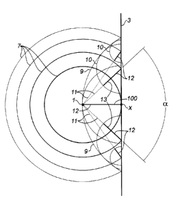
1 Having reference to Fig. 1, a series of analogous pressure wavefronts
2 7 are seen to travel radially outwards from a well 1. The distance that the
wavefront
3 7 extends from the well, at any time, is called the radius of investigation.
After a
4 period of time the initial extending wavefront 7 contacts a boundary 3 at
its leading
edge at point X. At this time, in our concept, the wavefront 7 is absorbed and
re-
6 emitted from the boundary 3, creating a returning wavefront 9.
7 Each individual wavefront 7 travels a smaller radial increment outwards per
unit
8 of time than does its predecessor, related to the square root of time. The
pressure
9 test data does not provide information about the actual boundary contact
until such
time as the returning wavefront 9 appears back at the well 1. This time is
referred to
11 as the radius of information. The radius of information compensates for the
lag in
12 information from the pressure test data and is determined to be 1/2 of the
radius of
13 investigation.
14 The radius of investigation, and therefore the radius of information, is a
function of the specific reservoir parameters and the total time of the well
pressure
16 test.
17 As the extending wavefront 7 continues to impact and widen on the
18 boundary 3, multiple sub-wavefronts or wavelets 10, representing the
boundary
19 interactions, are generated. Each wavelet 10 is a circular arc
circumscribed within the
initial returning wavefront 9. Each later wavelet 10 is smaller than the
preceding
21 wavelet and lags slightly as they were generated in sequence after the
initial contact.
8
2183113
1 Vectors 11 are drawn from the center of each wavelet 10 to the well 1.
2 Rays 12 are traced along each vector 11, from the center of each wavelet 10
to its
3 circumference. A ray length 12 which is less than that of the vector 11
indicates that
4 information about the boundary 3 has not yet been received at the well 1. A
contact
vector 100 extends between the well 1 and the point of contact X.
6 The length of each vector 11 provides information about the distance
7 from the well 1 to the boundary 3. A ray 12 drawn in the initial returning
wavefront 9
8 is equal to the length of the contact vector 100 and the distance to the
boundary 3.
9 When each ray 12 in turn reaches the well 1, as defined by the pressure test
elapsed
time, its length is equal to the radius of information. Reservoir parameters,
and
11 pressure and time data acquired during the transient pressure test are used
to
12 calculate the radius of information for each data pair.
13 The orientation of each vector 11 indicates in which direction the
14 boundary lies. The included angle between a pair of rays 13, formed from
the two
vectors 11 which are generated simultaneously when the wavefront 7 contacts
the
16 boundary 3, is defined as an angle-of-view a. As the wavefront 7
progressively
17 widens on an ever greater portion of the boundary 3, the angle-of-view a
for the ray
18 pair 13 increases.
9
CA 02183113 2000-11-22
1 In order to relate the angle-of-view to actual reservoir characteristics,
the
2 timing and spacing of the discretized wavefronts 7 is obtained from the
directly
3 measured pressure response data from the well 1 and is portrayed in a
Bourdet
4 Response Curve. Relationships of the angle-of-view and the pressure response
curve are determined as a function of the ratio of the actual Bourdet Response
Curve
BRa~ual and the ideal Bourdet Response Curve for an infinite reservoir BR ~ .
Near
7 wellbore and matrix behaviour uvas normalized out. Knowledge of the BR ~
using
8 conventional methods and the BRa~,~a~ from well test pressure data enables
9 calculation of the angle-of-view.
"I 0 The orientation of the angle-of-view is indeterminate and several models
are
'I 1 employed to assume the orientation of the boundary: the Angular Image
model; the
'12 Balanced Image model; or the Channel-Form Image model. The models assists
in
'I 3 orienting the boundary with respect to the contract vector. Each model
results in the
'14 determination of a different image of the reservoir boundaries. Only one
image is
'I 5 chosen as being the most representative of the geologic features of the
reservoir.
'16 In illustration and havinc,~ reference to Figure 2, an Angular Image model
'I 7 is reproduced from the '563 patent. The extending wavefront 7 is shown
contacting
'18 a boundary 3 formed of an assumed flat boundary portion 8 extending in one
'19 direction and the remaining boundary portion 14 extending in the opposite
direction
:?0 in one of either a flat 14a, concave curved 14b, or a convex curved 14c
orientation.
:?1 The exact orientation of boundary portion 14 is determined by applying the
angle-
:?2 of-view principle as referenced to the assumed geometry of boundary
portion 8.
:Z3 Vector 101 is determined geomEarically by determining the intersection 15
of the
2183113
1 radius of information with the flat boundary 8 for each ray pair 13. The
intersection
2 15 is one coordinate of the boundary for that radius of information.
3 An angle beta ~i is defined, calculated in terms of the arc-cosine of the
4 contact distance and the radius of information, which orients the
intersecting vector
101 relative to the contact vector 100.
6 An angle-of-view a is determined from the pressure response data.
7 Vector 102, returning from a boundary interaction, is then located by
8 rotating it an angle-of-view a relative to the intersecting vector 101 along
an arc drawn
9 at the radius of information from the well 1. Vector 102 may manifest in one
of three
forms 102a,b,c dependent on the orientation of the boundary. Clearly, if the
angle-of-
11 view a is greater than 2 x ~3, then vector 102b is seen to contact a
concave boundary
12 14b at a boundary coordinate 17. Conversely, if a is less than 2 x ~3, then
the vector
13 102c is seen to contact a convex boundary 14c at a coordinate 18. Finally,
if the
14 angle-of-view a is equal to twice the ~i angle then vector 102a contacts a
flat boundary
14, intersecting at coordinate 16. The contact 16,17 or 18 of vector 102
defines a
16 second coordinate 26 on the boundary at that particular radius of
information.
17 Having reference to Fig. 3, pairs of coordinates 15,26 are determined for
18 each successive radius of information, eventually developing enough pairs
of
19 coordinates to form an image of the boundary of the reservoir.
CA 02183113 2000-11-22
1 Thus far, this determination of the angle-of-view and the co-ordinates of
the
2 orientation of the boundary, is .as it was disclosed in the '563 patent. The
above
3 derivation has clearly identified that at a particular radius of
information, when a
4 boundary is encountered, it may be defined as having a length, in polar co-
ordinates,
equivalent to the angle-of-view a. What the above does not provide, nor does
the
6 well pressure data provide, is the information necessary to orient the
boundary. The
7 method thus requires the adoption of one of several simplifying assumptions
which
8 relates the boundary information at one radius of information to the
boundary
9 information for the immediately previous radius of information.
'10 The present invention instead treats the boundary information,
specifically the
'I 1 angle-of-view, calculated at each radius of information, as being
individuals, distinct
'12 from the others.
'13 Referring again to Fig. 3, the circumference of each radius of information
can
'14 be represented as being analogous to a ring 30. Reservoir encompassed
within the
'15 ring 30 is deemed to be in communication with the well 1. The
circumference of this
'16 ring 30 is interrupted only by thE: presence of a boundary 3, the
interruption having a
'17 circumferential length equivalent to the angle-of-view. Clearly, by
definition, the
'18 reservoir beyond the angle-of-view, or boundary, is not in communication
with the
19 well. In our view, the angle-of-view represents the sum of any and all
boundary
effects experienced by the analogous wavefront at that radius of information.
The
:~1 boundary encountered may be either a contiguous boundary, or two or more
:22 discontinuous, albeit smaller boundaries.
12
2183113
1 The ring 30 is therefore comprised of a circumferential or ring arc 31,
2 located in the reservoir, and an angle-of-view a, being an arc located along
a
3 boundary. The angle-of-view a may include one or more arcs a" a2, etc.,
4 representing multiple interactions of the radius of information with a
boundary or
boundaries. Correspondingly, the ring arcs 31 may include one or more arcs
residing
6 between these successive interactions with the boundaries.
7 Ring arcs 31 exist for each radius of information and are independent
8 from each other. More particularly, each ring arc may be individually fitted
to known
9 geologic features or boundaries.
The fitting process commences by examining successively larger radii
11 of information until a boundary contact X is located. This is indicated
when the angle-
12 of-view a first has a value greater than zero. Accordingly, a 360 degree
ring becomes
13 discontinuous to the extent of the angle-of-view and forms a ring arc.
Initially the ring
14 arc 31 has only two end-points 32, 33, located at each end of the angle-of-
view a.
The ring arc is rotated so as to cause one end-point to coincide with a
16 known geologic feature or boundary (not shown). The circumference of the
ring arc
17 is examined to determine if any additional geologic features are
intersected. If not,
18 then the fitting process moves onto the next successive and larger radius
of
19 information. When the rings arcs for all the radii of information have been
fitted, their
collective end-points describe the boundary.
21 The present invention is most conveniently described through the
22 presentation of the following examples.
13
CA 02183113 2000-11-22
1 Example I
2 Having reference to Fig. 4, a Bourdet Response Curve is shown for a well.
3 Applying an Angular Image model and the techniques disclosed in the '563
patent, a
4 theoretical or diagnostic image was conveniently formed, as shown in Fig. 5,
as a
series of rings. Those rings having their full circumference intact indicated
that no
6 boundary had yet been reached at that radius of information. Discontinuous
rings, or
7 ring arcs, indicate that the reservoir, somewhere along that radius of
information, was
8 interrupted by a boundary or boundaries. Referring to Fig. 6, geologic
lineament data
9 was available for assisting in grossly defining the geologic features of the
reservoir.
'I 0 Referring to Fig. 7, the diagnostic image was roughly positioned to fit
over the
'11 known geologic features. Stapling at the innermost ring arc, the closest
geologic
'12 feature was identified as S1. The ring arc was rotated so as to overlay
one end-point
'I 3 of the ring as close to that feature S1 as possible. The selected end-
point of the ring
'14 arc didn't quite contact the feature S1, indicating that the
characteristics of the
'I 5 "known" feature were not accurately understood. Successive ring arcs were
similarly
'16 rotated, one end-point of each ring arc being successfully positioned to
lay on the
'17 geologic feature S1.
'18 It may be seen from Fig.. 7 and 8 that the opposing end-points of the
rotated
'I 9 ring arcs (those end-points which were not purposefully overlaid on a
known feature)
:?0 also tended to correspond with known geologic features. More specifically,
these
;?1 opposing end-points appeared to consistently terminate at the geologic
feature S2 on
:?2 Fig. 7, more clearly recognized as a trough-like feature S2 in Fig. 8.
14
2183113
1 Example II
2 Example II illustrates the application of the invention where the angle-of-
3 view is a result of multiple discrete boundaries encountered at a radius of
information.
4 Having reference to Fig. 9, a Bourdet Response Curve is shown for a
different well than that presented in Example I. Applying an Angular Image
model, a
6 convenient diagnostic image was formed, shown in Fig. 10 as a series of ring
arcs.
7 A significant amount of geologic lineament data was available for this well,
as shown
8 in Fig. 11. Some of the geologic features are more significant than others,
such as
9 the major fault line identified as S4 and other less significant features.
An experienced
analyst can assist greatly in the identification of features of significance
and fitting of
11 the ring arc data to detailed geologic features as shown in Fig. 11.
12 Referring to Fig.l2, and starting at the innermost ring arc, the closest
13 seismic feature was identified as S3. The ring arc was rotated so as to
overlay one
14 end-point of the ring as close to that feature S3 as possible. Both the
selected end-
point and the opposing end-point quite closely corresponded to the feature S3.
16 Numerous additional ring arcs were similarly rotated which continued to
match the S3
17 feature.
18 At a certain radius of information, a ring arc 40 intersected not only S3
19 but also another significant feature S4. The end-point 41 of ring arc 40
was rotated
to coincide with S3. Then, ring arc 40 was cut at the intersection 42 with
feature S4.
21 A new end-point was formed at the cut to ring arc 40. The remaining shorter
portion
22 of ring arc 40 was again rotated until the cut end-point coincided at
intersection 43 on
23 feature S4. The opposing end-point 44 of the shorter ring arc terminated
back in the
24 vicinity of feature S3 again. Thus, the angle-of-view at this radius of
information 40
2183113
1 was seen to be comprised of two distinct and separated ring arcs 41 - 42 and
43 - 44
2 corresponding to boundaries 40 - 44 along geologic feature S3 and 42 - 43
along
3 feature S4.
4 At a much larger radius of information, ring arc 50 was rotated so that
end-point 51 coincided with feature S4. The opposing end 52 was seen to also
6 coincide generally in the vicinity of another geologic feature S5.
7 Having reference to Fig. 13, the rotated ring arcs are depicted on the 3
8 dimensional representation of the geologic structure, illustrating the
superior fit of the
9 angle-of-view information to the reservoir when some basic geologic features
are
known. This is to be compared with what can be seen to be a rather poor fit,
should
11 the diagnostic image of Fig. 10 be superimposed on the geologic lineaments
of Fig.
12 11.
16