Note: Descriptions are shown in the official language in which they were submitted.
- 2187487
Arthur F. Kuckes
ROTATING MAGNET FOR DISTANCE AND DIRECTION MEASUREMEIr'TS
Background of the Invention -
The present invention is directed, in general,, to a
method and apparatus for guiding directional drilling of a
borehole, and more particularly to the generation of rotating
l0 magnetic fields for use in precisely measuring the distance and
direction between an existing borehole and a borehole being drilled
to achieve precisely controlled separation between the two
borehoies.
Precise control of the distance between one or more
1~ existing wells, or boreholes, and a new well, or borehole being
drilled is required from time to time in the oil and gas industry.
For example, when a group of wens are drilled from an offshore
platform, it is often necessary to drill new wells spaced three
meters or less from existing wells for a distance of 300 meters or
20 more during the initial depth interval before the wells are
directionally deviated and drilled to targets which may be two
kilometers or more away in lateral directions. Another~example is
found in the drilling of twin horizontal wells for steam-assisted
gravity drainage (SAGD) of heavy oils. In this latter case, it is
25 necessary to drill one well directly above the other while
1
2187487
maintaining a five meter (~2 meter) spacing over 500 meters of
horizontal extension at depths of 500 or more meters.
It is a common practice during the initial phases of
drilling a well from a platform to perform numerous gyrdscopic
surveys to achieve the very precise drilling required to avoid
collisions with neighboring existing wells. Such surveys, however,
require dedication of the entire drilling rig for that purpose, and
the time associated with repeated survey$ of this kind, in addition
to the lost production of oil due to the requirement of shutting
down nearby producing wells during the period of drilling, gives
great motivation for finding a better way to control the drilling
operation.
Drilling twin horizontal wells to the specifications
required for steam assisted gravity drainage wells is not possible
with the usual gyroscopic and earth's magnetic field-based
surveying methods, due to the lack of precision of such techniques.
An alternative method for drilling well pairs is to use a
controlled solenoid source in the first well of the pair in
conjunction with a measurement while drilling (MWD) system in the
second well. Such an MWD system senses the relative location of
the nearby solenoid, and this downhole ranging technique has worked
reasonably well during recent tests. However, such a technique has
the limitation that in most directional drilling systems the drill
bit is driven by downhole, fluid-powered motors, which are
approximately 10 meters long. The measurement while drilling
surveying electronics is mounted inside a ten meter long non-
2
2187487
magnetic drilling collar section following the fluid powered
motors. As a result, with this system the basic measuring point in
the MWD apparatus is 15 or more meters behind the location of the
drilling bit. This results in a depth lag between the measuring
point of the survey instrument and the drill bit so that drilling
direction adjustments are not made soon enough.
Summary of the Invention
It is, therefore, an object of the present invention to
produce a measurement while drilling system which allows continuous
drilling of boreholes while permitting precise measurement of the
distance and direction between the borehole being drilled and
nearby existing boreholes.
It is another object of the invention to provide
measurement while drilling apparatus in which a rotating magnetic
field source is provided near a drill bit in a borehole being
drilled for use in accurate and reliable measurements of the
distance and direction from the drill bit to a nearby borehole to
thereby permit precise control of the separation between the
boreholes.
In accordance with the present invention, the distance
and direction from a first borehole to a second borehole is
determined by locating in one borehole, preferably the borehole
being drilled, a rotating magnetic field source. This magnetic
field source may be a permanent magnet mounted near the drill bit
of a conventional drill string, with the north-south axis of the
3
2187481
magnet being perpendicular to the axis of rotation of the drill.
The magnetic field source produces a rotating, elliptically
polarized magnetic field in the earth surrounding the borehole
being drilled, the magnetic field extending into the region of a
prior, or existing, borehole. This prior borehole may be an
existing well which is to be avoided, for example, or may be a well
which is to be tracked for precise parallel drilling of a second
borehole. Magnetic field sensors, preferably a pair of highly
sensitive fluxgate magnetometers, are positioned at an observation
point in the first borehole within the elliptically polarized
magnetic f field generated by the rotating magnetic f field source . In
a preferred embodiment of the invention, the amplitude and relative
phase of first and second components of the rotating magnetic field
are detected by the sensors and the direction from the observation
point to the magnetic field source is determined. This direction
may be determined with respect to magnetic north or with respect to
the high side of the existing borehole in order to determine the
absolute direction to the borehole in which the rotating field
source is located. If desired, a gyroscope may be used as a
reference, with the direction to the magnetic field being
determined with respect to that reference.
The distance from the observation point in the first
borehole to the location of the source in the second borehole may
also be calculated, in accordance with the invention, by
determining the strength of the magnetic ffield source and comparing
that known strength with the value measured at the observation
4
2187487
point, since the field strength is inversely proportional to the
cube of the distance from the source. However, because the
observation point usually will be located within a casing of
unknown magnetic characteristics, the effective strength'of the
magnetic field source for purposes of determining distance will
differ from the actual field strength obtained from a direct
measurement at the source. Accordingly, in a preferred embodiment,
the effective field strength is determined by measuring, at plural
observation points within the first borehole, amplitude variations
with depth of the total magnetic field and computing theoretical
variations in the amplitude for different assumed distances between
the two boreholes. Thereafter, a measured amplitude is compared
with the computed values to determine the distance. This
computation may also be used to determine the effective strength of
the magnetic field source, and thereafter that calculated effective
strength can be used directly in further determinations of distance
by simply measuring the amplitude of the magnetic field at the
observation point.
In another embodiment of the invention, a pair of spaced
axial component magnetic field sensors may be provided in the first
borehole to measure the axial field gradient of the rotating
magnetic field. This field gradient provides an indication of
whether the observation point is approximately coplanar to the
rotating magnet, and thus provides a measure of their relative
depths. This field gradient can also be used to determine the
effective strength of the field source for obtaining direct
5
2187487
measurements of radial distance between the rotating magnet and the
sensor at the observation point, as outlined above.
Brief Description of the Drawings-
The foregoing, and additional objects, features, and
advantages of the present invention will be apparent to those of
skill in the art from the following detailed description of
preferred embodiments thereof, taken in conjunction with the
accompanying drawings, in which:
Fig. 1 illustrates a pair of horizontal, spaced wells in
which the measuring system of the present invention is utilized for
guiding a rotating drill bit carried on a drill string located in
a well being drilled;
Fig. 2 is a diagrammatic illustration of the direction
and strength of a magnetic field produced by a rotating magnetic
field source carried by the drill string of Fig. 1;
Fig. 3 is a schematic representation illustrating the
mathematical analysis of the relationship between the rotating
magnetic field source and measurements made at an observation point
spaced from the source;
Fig. 4 is a curve illustrating the values of theoretical
calculations utilized in the method of the present invention;
Fig. 5 is a diagrammatic illustration of apparatus
constructed to evaluate the utility of the system of the present
invention;
6
2187487
Figs. 6 and 7 illustrate the results of calculations made
in accordance with the present invention; and
Fig. 8 illustrates the relationship of a sensor for
measuring axial field gradients to the rotating magnetic~ field
source.
Description of Preferred Embodiments:
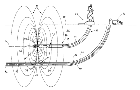
Fig. 1 diagrammatically illustrates the method and
apparatus used, in accordance with the present invention, for
guiding directional drilling of a second borehole to achieve
precisely controlled separation with respect to a first, previously
drilled borehole. Thus, in Fig. 1 a borehole 10 contains a drill
string 12 incorporating a drill assembly generally indicated at 14.
The drill assembly includes a drill bit 16 which is driven by
suitable motors 18 in conventional manner, to rotate about a
longitudinal axis of rotation 17, the drill bit being steerable to
control the direction of drilling in response to control signals
from a control station 20 located at the surface 22 of the earth
23. In accordance with the invention, an elliptically polarized
rotating magnetic field is generated in, and is centered in, the
borehole being drilled. For this purpose, the drill assembly 14
carries a field source such as a permanent bar magnet 24 mounted in
a non-magnetic piece of drill pipe 26 located just behind the
rotating drill bit 16. The magnet is carried by the drill string
12 with north-south axes of the magnet perpendicular to the axis of
rotation 17 of the drill bit 16. This bar magnet generates an
7
2187487
elliptically polarized magnetic field generally indicated by the
magnetic field lines 30, with the rotation of the magnet 24 about
axis 17 producing an alternating magnetic field at an observation
point radially spaced from the magnet.
An existing borehole 32 is illustrated in Fig. 1. This
borehole 32 is illustrative of a horizontal well of the type which
may be used for steam assisted gravity drainage of heavy oil. The
borehole 32, which may include a casing 34, is a target well which
is to be followed by the borehole 10 being drilled. In accordance
with one example of the present invention, the drill bit 16 is
controlled so that the borehole 10 is drilled directly above
borehole 32 and is spaced above it by a predetermined, constant
distance. Control of the drill bit 16 is carried out in response
to measurements made in the target borehole 32 by means of a
magnetic field sensor 36 located in a measuring tool 38. The
measuring tool is lowered into the borehole 32 through casing 34 by
means of a suitable wireline 40, with the location, or depth, of
the measuring tool being controlled from the earth's surface in
conventional manner from an equipment truck 42.
The magnetic field sensor 36 is located at an observation
point 44 and incorporates, in a preferred embodiment, a pair of
fluxgate magnetometers 46 and 48 (Fig. 2) having their axes of
maximum sensitivity intersecting each other at the observation
point and at right angles to each other. The magnetometers measure
the amplitude and the phase of two perpendicular components of the
polarized rotating magnetic field 30 which are both perpendicular
8
2187487
to a longitudinal axis 49 of the measuring tool 38. The measuring
tool also incorporates, in one form of the invention, an
orientation sensor 50 for determining the orientation of the
magnetic field sensor 36 with respect to either the borehole or to
magnetic north. Such orientation devices are well known, and may
include earth's field sensors, inclinometers, and/or a gyroscope.
The relationship between the rotating magnetic field
source 24 and the magnetic field sensor 36 is illustrated in Fig.
2. As illustrated, the magnetic field source 24 may be a permanent
magnet or an electromagnet rotating about a source point 60, which
lies on the axis of rotation 17 of the drill bit 16 in Fig. 1.
This axis 17 is essentially parallel to the axis 49 of the
measuring tool 38 which passes through the observation point 44.
As illustrated, magnet 24 may rotate in, for example, a clockwise
direction, producing at the observation point 44 variations in the
direction and strength of the magnetic field 30 in synchronism with
the rotation of the magnet 24. When the south pole of the magnet
24 points toward the observation point 44 along radial line 62
joining source point 60 with observation point 44, the magnetic
field 30 at the observation point is directed away from the source
and is aligned with the radial line 62, as illustrated by magnetic
field vector Bo. When the magnet 24 rotates 90° clockwise, the
magnetic field vector at the point of observation rotates
counterclockwise by 90°, as illustrated by the vector B9o. Thus,
the magnetic field vector indicated generally at 64 at the
observation point rotates in a sense opposite to that of the source
9
2187487
magnet 24, and as the field vector rotates, its strength changes
from Bo to B9o, then to Bl8o, B2~o and back to Bo. The locus of the
points defined by the tip of the field vector 64 follows an
elliptical path 66, with the tail of the vector 64 being faxed at
observation point 44. A magnetic field vector which rotates with
temporally changing strength in this manner is said to be
elliptically polarized.
The radial line 62 connecting source point 60 with
observation point 44 coincides with the major axis 67 of the
ellipse 66 and with the vectors Bo and Bl8o. Since the magnetic
field a fixed distance off the end of a bar magnet is twice as
strong as the field at the same distance off the side of the bar
magnet in the plane of rotation, the magnitude of the voltage
generated by a magnetic field sensor which is aligned with the
major axis of the ellipse and which thus points toward the source
will be double that of a sensor whose axis of sensitivity is
perpendicular to the major axis of the ellipse. In addition, there
is a time difference between the maximum field vector component
measured by the sensor aligned with the major axis and the maximum
vector component measured by the sensor in the perpendicular
direction. This time difference is equal to 1/4 the rotation
period of the rotating vector, and thus is 1/4 the rotation period
of the rotating magnet 24. This coincidence of the major axis of
the magnetic field polarization ellipse with the direction to the
source and the associated field phase and amplitude relationships
constitute the physical basis for being able to evaluate the
2187487
direction to the source point 60 from the observation point 44.
This evaluation utilizes the amplitudes and the phase relationships
of the voltages generated by the pair of fluxgate magnetometers 46
and 48. These magnetometers are preferably at right angles ~to each
other and perpendicular to axis 49, with an arbitrary orientation
within the borehole 32, and thus with respect to the radial line
62.
Fig. 3 is a schematic representation of the quantities
used in evaluating the distance and direction from the observation
point to the source. The figure is a sectional view of a plane
which is perpendicular to the axis of the drill assembly 14,
looking in the direction of drilling borehole 10, the figure
illustrating the various quantities used in the mathematical
analysis of the field measurements for determining distance and
direction. Figure 3 illustrates diagrammatically the rotating
magnet 24 which rotates about source point 60 and axis 17 in a
clockwise direction, in the manner described with respect to Fig.
2. Magnet 24 is illustrated as having a rotating north-south axis
70. The magnetometers 46 and 48 located in the neighboring target
borehole 32 at observation point 44 are at right angles to each
other, with the axis of sensitivity 72 of magnetometer 46
representing the x-axis while the axis 74 of magnetometer 48
represents the y-axis in the magnetometer plane. The radial
distance r between source point 60 and observation point 44 is
again indicated by radial line 62. The plane of measurement
illustrated in Fig. 3 is also perpendicular to the axis of the
11
2187487
measuring tool 38. For optimum results, the plane of measurement
is at a drilling depth where the magnetometers 46 and 48 and the
rotating magnet 24 are coplanar, since both the intensity and the
ellipticity of the magnetic field 30 are at their maximum values.
Mathematically, the field of magnet 24 is described by a
magnetic dipole pointing in the direction m and having a strength
of m Weber meters. The dipole 70 rotates at a rate of w
radians/second so that the angle of axis 70 with respect to a
reference direction 75 at a time t is given by the product wt. The
angle Amr denotes the angle between m and the direction of the line
62 from the source point 60 to the observation point p at point 44,
line 62 representing the unit radius vector r.
The axes of the magnetometers 46 and 48 are indicated by
unit direction vector x, illustrated by line 72, and by unit
direction fector y illustrated by line 74. These two unit vectors
are perpendicular to each other when the magnetometers are
perpendicular to each other, and both are perpendicular to the axis
49 of the plane of Fig. 3; thus, they are perpendicular to the axis
of the measuring tool 38 which extends through observation point
44. The goal of the mathematical analysis is to find the angle Axr
(Fig. 3), which is the angle between line 72 representing the unit
vector x and line 62 representing the unit vector r. The analysis
is also designed to provide the distance r from the measurement of
the field component BX in the x direction and from the measurement
of the magnetic field component BY in the y direction. This
analysis is carried out as follows:
12
2187487
Electromagnetic theory gives the field component Br in
the radial direction r and the field component Bq in the azimuthal
direction q (90° from r) at the observation point 44 as
m
Br = 2 cos (Amr) - 2 M cos (wt - Atr) (Eq. 1)
4 ~r r3
and
m
Bq = sin (Amr) - -M sin (wt - Atr) , (Eq. 2)
4 ~r r3
where
m
M - and Amr = Atr - wt , (Eq. 3)
4 ~r r3
m being the strength of the magnetic field source and Amr being the
angle between the direction of m at time t=0 and the direction of
the observation point, represented by r.
Noting Fig. 2, the rules of vector projection give:
BX = Br cos (Axr) - Bq sin (Axr) (Eq. 4 )
BY = Br sin (Axr) + Bq cos (Axr) (Eq. 5)
Inserting Eqs. 1 and 2 into 3 arid 4 and using the
J
trigonometric relationship cos (A+B) =cos (A) cos (B) -sin (A) sin (B) , the
following is obtained:
BX = M ~os (Axr) 2 + sin (Axr) 2 cos (wt - Atr - PX) (Eq. 6)
2 cos (Axr)
cos (PX) - (Eq. 7)
4 cos (Axr) 2 + sin (Axr) 2
13
~ 18148?
sin (Axr)
sin(Px) - (Eq. 8)
4 cos (Axr) 2 + sin (Axr) 2
BY = M r sin (Axr) 2 + cos (Axr) 2 cos (wt - Atr - PY) (Eq. 9)
2 sin (Axr)
cos (PY) - (Eq. 10)
4 sin (Axr) 2 + cos (Axr) 2
-cos (Axr)
sin (PY) - (Eq. 11)
4 sin(Axr) + cos(Axr.
where Px and PY are defined by equations 6 and
9.
Inserting the above values for the sin and cos of and
Px
PY into the and sin (Px
trigonometric - PY) ,
formulae
for cos
(Px - PY)
the following
is obtained:
4 cot (Px - PY)
sin (2 Axr) - + (Eq. 12)
3
5 ( ~ Bx ~ 2 ~ By ~ Z )
cos(2 Axr) - (Eq. 13)
3 ( (Bxl2 + IBYIa)
atan2(sin(2 Axr), cos(2 Axr))
Axr =
(Eq. 14)
2
where ~ Bx ~ arid ~ BY ~ denote the magnitude of Bx and BY and the
function atan2 is the four quadrant inverse tangent function. The
fact that the angle Axr given by relations 12-14 leaves a 180
degree ambiguity in that angle is usually not a problem. Eq. 14
gives the important, and at first sight surprising result, that by
measuring the amplitudes ~Bx~ and ~BY~ of the alternating magnetic
14
2187487
fields in the x and y directions, together with the relative phase
angle between them (PX - Py), it is possible to determine the angle
between the axes of the sensors and the radial line connecting the
source and the observation point. This makes it possible to
determine the relative direction of the source point 60 with
respect to the magnetometers 46 and 48. Then, to find the absolute
direction to the source, the orientation of the magnetometers in
space is determined by the orientation sensor 50.
One way to orient the magnetometers 46 and 48 is to
determine the direction of the high side (Hs) of the borehole (i.e.
vertical) in which the magnetometers are located, and then to
determine the angle Ahx, which is the angle between the axis x of
the magnetometer 46, for example, and the direction of the
projection of the vertical Hs onto the plane of measurement.
Thereafter, once the angle Axr is determined, as discussed above,
it can be combined with the angle Ahx using a pair of inclinometers
in sensor 50, as is well known by those skilled in the art.
Alternatively, instead of using the vertical, or Hs
direction to orient the magnetometers, projections of true North or
magnetic North directions onto the plane of measurement can be
done, utilizing earth's field sensors, as is well known by those
skilled in the art. The angle between true North and x is added to
angle Axr to obtain an absolute direction to the source. As
another alternative, a gyroscope can be used in the sensor 50 to
orient the magnetometers 46 and 48.
2187487
The distance r between the source point 60 and the
observation point 44 is found from the measurements using the
relationships derived from Eqs. 1-14 as follows:
m 5
r = ( ) 1~3 ( ) 1~6
4 n IgXI2 + Igyl2 (Eq~ 15)
The distance r can be evaluated from Eq. 15, provided the source
strength m is known. Although the value of m can be readily
determined at the earth's surface, the effective value of m
downhole may be different, particularly if the measuring tool 38 is
located within a steel casing 34, which significantly attenuates
the magnetic field. Accordingly, the effective value of m may be
determined by moving the measuring tool 38 along the axis of the
borehole 32 and measuring the variation of the magnitude of the
magnetic field as the relative depths of the sensor and observation
point vary. This can be accomplished, for example, by holding the
depth of measuring tool 38 fixed and observing the magnetic field
signals as drilling progresses (and the location of the magnetic
field source moves) . The drilling depth corresponding to the point
of approach, i.e., when the sensors 36 and the rotating source 24
are opposite each other and the observed magnetic field is
strongest, as in the considerations above, defines a convenient
reference depth for z, i.e., the depth where the parameter z,
representing the axial distance from the plane of the sensors to
the plane of the source, is 0. As the value of z is varied, the
observed value of the magnitude of the field, Bmag, varies as
16
2187487
Bmag ° l( ( Bx , 2 + ' By l 2 ) _ m ~ 2 ( z / r ) 4 -2 ( z / r ) 2 +
5
d ' , 4 ~r r3 (1 + (z/r) 2) 5/2
(Eq. 16)
The z/r dependance of -Bmag is illustrated in Fib. 4 by
bell-shaped curve 80, which has a characteristic full width~at half
height which defines a half height parameter (zl - z2)/r = 1.085 .
The half height points 82 and 84 of the bell-shaped curve generated
by a set of observations of Bmag vs. depth define a depth interval
Dzhh = (zl - z2) from which the distance r between the wells is
readily found; i.e.
r = 1.085 Dzhh (Eq. 17)
Thus, the distance between the wells can be found in a simple way
by noting the variation of the total alternating field intensity
with depth without knowing the magnitude of the source strength.
The value of r thus found and the field magnitude values ~Bx) and
~By~ observed at the point of closest approach can then be used in
conjunction with Eq. 15 to evaluate the source strength m. Once
the source strength is evaluated by this analysis during one
interval of drilling, it can usually be used for the entire well.
To apply the above results in practice usually will
require some signal averaging, particularly if it is desired to
realize the maximum range and precision inherent to the method.
This can be done using a commercially available lockin amplifier.
If an electronic lockin amplifier is used it should include a phase
locked loop in the reference channel so that the slowly varying
frequency of the signal can be followed. It will usually be more
17
2187487
convenient to use digital techniques and to computationally encode
the lockin amplifier functions of frequency locking and signal
averaging. Alternatively, one can use well known mathematical
methods of signal correction analysis using fast Fourier transforms
as discussed in Numerical Recites in Pascal, by Press, Flannery,
Teukolsky and Vetterling, Cambridge University Pres, 1989 pages
457-462.
Tests of the system of the present invention were
performed using the apparatus illustrated in Fig. 5 to evaluate the
utility of the system and the effect of having the sensors 36
inside a steel pipe corresponding to casing 34, where the signal
was attenuated by about a factor of 3. A motor 86 was used to
rotate a samarium cobalt magnet 24 at about 60 rpm to simulate the
rotation of a drill bit with a magnet mounted on it. A two-
component "x y" fluxgate magnetometer 36 was mounted inside a 7
inch diameter steel casing 34 a few meters away on a.protractor so
that the angle of Axr with respect to the direction to the source
could be changed. The magnetometer outputs were connected, one at
a time, to an Ithaco NK type 3962 Lockin Amplifier 88. The
reference channel for the local clock in the Ithaco instrument was
provided by a third magnetic sensor 90, a small induction coil
pickup near the rotating magnet and having its output connected to
the phase lock circuitry of the Lockin amplifier. The results of
using the analysis of this disclosure to provide information needed
to compute the direction between the source 24 and the x axis of
the magnetometer pair is shown in Figs. 6 and 7. The dominant
18
2187487 _
error in the measurement was due to distortion of the azimuthal
component of the rotating magnet due to large machine tools being
on either side of the sensors. Even with this error the results
were satisfactory, indicating that highly accurate measurements
would be attained upon elimination of the source of the error. The
apparatus was also used to precisely measure the field inside the
pipe with the rotating magnet over 12 meters away.
The relationships described above have assumed that the
magnetic field source and the field sensor are coplanar, lying in
a common plane that is perpendicular to the axes of both the target
borehole and the parallel borehole being drilled. However, the
accuracy with which the distance and direction from the drill
location in the borehole being drilled to the observation point in
the target borehole can be determined is significantly improved by
taking into account the possibility that the source and the sensor
may not be coplanar. This may be accomplished by measuring, at the
sensor location, not only the magnetic field components in the x
and y directions described above, but also the magnetic field
component in the z direction; i.e. the axial field component, and
more particularly the axial field gradient.
When the magnetometers at the observation point are
coplanar with the rotating magnetic field source 24, as illustrated
in Fig. 2, the axial component of the magnetic field 30 at the
measuring point is zero. Thus, by measuring the axial field
component at the sensor, it is possible to determine whether the
source and the sensor are approximately coplanar. If this
19
218787
component is sufficiently small, the determination of distance and
direction will be accurate. Furthermore, measurement of the axial
field gradient, as by measuring the difference between the axial
fields at two spaced points along the axis, can permit
determination of the depths in the respective boreholes where the
rotating magnetic field source and the sensor are coplanar. In
addition, measurement of such a gradient can permit determination
of the radial distance to the source.
To show these facts quantitatively, consider the
mathematical relations which give the axial component of a magnetic
field, i.e., Bz at an observation point r, z where r is as shown in
Fig. 3 and z as in Fig. 8, with the observation point at 44. The
magnetic field component Bz in the z direction z is given by
3mrz
Bz - ______________ (Eq. 18)
4'lr ( r2+z2 ) s/z
and the axial gradient of Bz, i.e., dBz/dz is given by
3mr 5 zz
dBz/dz - ______________ (1 _ ______) (Eq. 19)
47f (r2+z2) 5/2 r2+z2
For z/r «1, which is often the case, are obtained the dominant
terms
Bz/(dBz/dz) - z (Eq. 20)
which finds the depth interval to coplanarity. Again, for z/r «1:
(dBz/dz) - 3m/ (4~rr4) (Eq. 21)
From equation (21) the radial distance of r to the source
is determined.
The depth variation, i.e. the z dependance, of the
magnetic field ellipticity is another quantity of interest. It is
- 2187487
convenient to define this ellipticity parameter in a way which
conforms to the linear, circular and elliptical polarization of
electromagnetic waves. After noting geometric considerations and
equations (1) and (2), the "polarization ellipticity" parameter E
of the magnetic field components perpendicular to the axis of
rotation of magnet 24 is:
E = (-2+(z/r)2)/(1+(z/r)2) (Eq. 22)
The physical manifestations of this relation are that for
large values of z/r, i.e., at points which are essentially on the
axis 60 of magnet rotation, E=1. This corresponds to the magnetic
field vector being circularly polarized; it rotates in synchronism
and in the same direction as the magnet. At the point where
(z/r)=~, then E=0. In this case the magnetic field component
perpendicular to the rotation axis 60 in the plane defined by the
observation point 44 and the magnet rotation axis 60 goes to zero
and the magnetic field vector is linearly polarized, with the
direction of polarization being perpendicular to the plane defined
by the measuring site 44 and the magnet rotation axis 60. Finally,
at z/r=0, E=-2, corresponding to the elliptical polarization
considered in Fig. 2, the field component in the plane defined by
the measuring site 44 and the axis of rotation 60 is double that in
the perpendicular direction. The sense of magnetic field rotation
in this case is opposite to that of the rotating magnet.
Often the measuring site 44 will be inside a steel casing
34, as noted above, which because of its large magnetic
permeability has the effect of "magnetically shielding" the
21
2187487
interior volume of the pipe. This shielding effect is greater on
the perpendicular component of the magnetic field than on the axial
component. For a 7 inch diameter casing the perpendicular
component may be attenuated by a factor of 3 or more whereas the z
component may only be attenuated by 20% or 30%. Under these
conditions, the axial field component and its gradient not only
give a good distance determination but also often can be used
advantageously to provide a reference channel for doing correlation
analysis or digital lockin analysis of the smaller perpendicular
field components.
An important application of this method and apparatus is
to drill SAGD twin wells (Steam Assisted Gravity Drainage twin
pairs) where two horizontal wells are to be drilled as shown in
Fig. 1 with a separation of, for example, 5+/-2 meters for a
kilometer or more of horizontal extension. The operational
procedure for doing this will be described. The lower well 32
(Fig. 1) is drilled first using normal horizontal MWD guidance
techniques. Typically, after 1000 meters of such drilling an up
down uncertainty of +/-5 meters and a left right uncertainty of +/
30 meters accrues.
The vertical section 96 (Fig. 1) of the second well 10 is
also drilled using normal drilling protocol, but at the start of
drilling the horizontal section 98 of the second well, the
measuring tool 38 including sensor 36 is "pumped" down a 3 inch
diameter tube such as casing 34 in the well 32, as shown in Fig. 8,
to a distance d approximately 5 meters beyond the depth of the
22
2187487
drill bit 16. The drill assembly 14 carries the rotating magnet 24
as described above. This measuring tool includes inclinometers for
determining the rotational orientation of the tool with respect to
the vertical direction, or high side of the borehole, two fluxgate
magnetometers with axes perpendicular to the tool axis 49~ in the
center of the tool, and two axial component fluxgate magnetometers
100 and 102, one at each end of the tool 38 and separated from one
another by approximately 3 meters. Magnetometer circuitry
connected to the respective magnetometers includes analog to
digital converters with approximately 16 bits of resolution so that
both the earth field and the small magnetic field fluctuations
associated with the nearby rotating magnet can be measured.
Drilling of borehole 10 is usually done 10 meters at a
time, i.e., the separation of conventional drill stem joints is
approximately 10 meters so drilling is halted every 10 meters to
add a drill pipe section. After the measuring of tool 38 has been
deployed as described above, in soft formations it usually requires
about 20 minutes to drill 10 meters. During this entire period the
drill stem is maintained on a predetermined course by closely
watching the outputs of the MWD package and orientation of the
"bent sub" portion of the drill stem in a manner known by those
skilled in the art of directional drilling. During this period the
measuring tool 38 in the target borehole 32 is held stationary and
is constantly registering measurements, with a computer constantly
doing the required signal averaging and the field correlations
discussed and described above. At the end of the 10 meter "joint"
23
2187487
drilling is~ stopped, an MWD borehole survey taken and a new section
of drill pipe is added to the stem.
During this period of adding a new drill pipe section,
the output of the magnetometers and inclinometers in the measuring
tool are analyzed. The field ellipticity and its variation with
depth as well as the field and field gradient values are analyzed
to determine the direction and distance to the reference well. The
drilling direction adjustments for the next 10 meters are then
decided upon. The measuring tool is then pumped ahead 10 meters,
the 10 meter value being adjusted from the measurements made during
the last interval of drilling so that the package is optimally
positioned for the next interval of drilling.
Although the invention has been described in terms of
preferred embodiments, it will be understood that modifications may
be made without departing from the true spirit and scope thereof as
defined in the following claims.
24