Note: Descriptions are shown in the official language in which they were submitted.
~ 2~91~54
Wo 95/33973 ' ~CT/DE 95/C~639
~E~HOD FO~ THE Co~LECTION, ANALYSIS, MEASUREM~T AND
S~o~AGE OF GEOGRAPHICA~ ~ATA
The invention relates to a method for the collection,
analysis, measurement ana storage o~ geographical data and is
intended for manifold space-arranging provisions o~ planning
and decision-making institutions in government, public
planning corporations, private planners, architects, and
engineers. This accordingly involves city planning, land
reallotment, land use planning predoninantly in rural areas,
and planning of traf~ic infrastructure provisions (roads,
rails, waterways, land records, regional pl~nni~g, agrarian
planning, forestry, ana envi~ 1 protection~.
current technology in handling sur~eying tasks is based
on the extensive development in screen image procesSing, CAD,
and screen-image graphics integration, including associated
alp~m~r~rical information (attributes) in so-called
geographical data processing systems. Analog images can be
digitized with high resolution. For processing the large
amount of data created in the process, an appropriate
computation techni~ue is available. German Patent Publication DE A 32 19
032 discloses an embodiment in which the intent is to recover
the orientation data from an aerial camera and a digital
terrain form model. Three sensor lines arranged transversely
or obli~uely to the flight direotion, and an associated
optical element are used. By continuous line scanning, three
image strips of the terrain are produced, each taken from a
different perspective. To that end, it is proposed that
pixels distributed in a mesh, preferably in the middle strip
of the image, be specified; that the corresponding pixels and
the associated line numbers be determined by area cor~ection
in the other two image strips; to approximate the orientation
parameters of the camera from the approximately known flight
2~9~954
~~ 95/33973 PCT/DE 95~0639
motions for every point, and by three-dimensional
foresiqhting to determine the terrain coordinates o~ the
point approximately: to set up beam intersection connections
for the three beams belonging to one point; and via error
e~u~tions and a compens'ation process to ascçrtain the rost
likely and final values of the orientation parameters and the
point-terrain coordinates.
An embodiment according to l~uropean Patent Publication EP A 0 237 601
is also known, according to which the photogram~etric
detection of an object is done with the aid of an
optoelectronic solid-state area sensor in the form of partial
images via a large image format, i~ the position of the
sensor is ~P~rminP~ in the image plane by means of a
network. This can be done by copying at least one network
mesh in the sensor irage. After the network points in the
coordinate system of the partial image are measured and
transformed to the desired ~alues in the system of the
network, the position of the area sensor and transformation
parameters for all the pixels within the network mesh are
ootained. To that end, the approximation position of the
sensor must be ade~uately well known to enable ~etPrm;nlng
the number of the network mesh as an une~uivocal
iaentification of the network points.
According to German Patentpublication DE A 381)2541, i~ is known tTlat
in initial aerial i~age-taking flights at an altitude of
between about 150 m and 500 m above the ground, aerial survey
pictures are collected, taken with prospecting cameras (2) in
combination with telecham~ers (3) for producing detail
pictures from the regional detail covered by the prospecting
cameras (2). The aerial survey lmages are defined by ~eans
of orientation aids with respect to their actual position on
the ground and evaluated using methods of photogrammetry.
The ascertained ground position data of a structure are
2 1 9 1 954
.
WO 95/33973 ~CT/D~ 95/0~639
associated, in such a way that they can be called up
selectively, with the t-n~rtl;nAteS of the structure on the
ground.
According to German Patent Publication DE A 383057~, the forming of
the object pixel signals is done by digital control of the
sampling period ~ty of the a priori analog, parallel
deteCtOr signals and their storage in (M) memories, from
which an analog line signal s(t) is formed by serial readout,
which line signal is sampled in (n) constant periods Atx,
and from that the final slgnals corresponding to the object
pixels (B) are formed; the sanpling periods ~ty and ~tx
each represent functions of the sampling distance (E) or
flight altitude (h) ana the sampling angle (w).
~ :ast German Patent Publication DD 237211 relates to a circuit
arrangement for automatically operating a photogrammetry
camera. It can be used to produce serial aerial pictures and
is intended to aid in precluding defects that can occur i~
the camera is operated ~anually, and to reduce the burden on
the human~operator to a mini~ur.. ~he variables necessary for
controlling the photogrammetric camera, such as the ratio of
speed to altitude, drift, and exposure time, are ascertained
by suitably ~ ~m;nt~fl correlations. Two discrete
photoreceiver cells, disposed at right angles to the flight
direction and called up in a certain time-slot pattern,
furnish relevant information for ~o~ming the control
variables regarding the terrain flown over.
A method of gravity surveying from the air according to
German Patent Publication DE A 3612674 is based on the use of an aircraft
that is stabilized with regard to.speed, course and altitude
and that includes a gravity ~eter of suitable sensitivity.
~ts signals and other signalb are plotted with a high
~ampling rate on magnetic tape, so that the location
(position) of the aircraft can ~e calculated, etc., either on
2 1 9 ~ 954
WO 95/33973 PCT/DE 95/00639
the basis of a satellite locating fiystem or a ground based
navigation syste~, referred to geodetically precisely known
pOints, that ~urnishes a plurality of navigation parameters,
such as bearing directions or distances.
A disadvantage is that the aforementioned known
embodiments have thus far not be used together, technically
and technologically coordinated, for the collection,
analysis, measurement and storage Or geographical data, but
instead are in the form of isolated ~ho~ nts from one case
to another, hence so far there has been no self-contained~
all-encompassing syste~ for the collection, analysis,
measurement and storage of geographical data.
The publication IC~ Te.cb~ica.l Journal, Vol. 6, No. 3, May 1989,
Oxford, pages ~42 to 5~6; J.M.P. Quinn: "...Towards Geographic
Information System," provides a solutiom, according to which
available data is o-~n~ t~-to a conventional database, whereby a
combination of the measured data with the spatial data is
achieved, whereby th~ vector~data is ob.tained frQm the picture
data.
The disadvan~age Qf thi~ solution is, among other things, that
the accomodation Qf =
* Air picture vertic~l recording
* satellite supported plotting and
* satellite r~vigatiDn data
* stereoscopic observation
* radar plotting
* microwaves
* scans
* aerial triangulation
is not possible.
To overcome the aforementioned disadvantages of the prior art,
it is the object of the invention to develop a method for the
~ 21 91 954
Wo 9S/33973 . ~ PCT~D~ 95/00639
collection, analysis, measurement and storage o~ geographical
data that guarantee5 practical data handling and simplified
availability in large, medium-sized and small user centers,
and that allows optimization of existing C~ UJI~I~LS in
dlgital stereo work stations with interactive superposition,
fitting in and continuation o~ digitally collected landscape,
planning, or real property data or land records maps, and
with supplementary alphanumeric information~
The engineer, pro~essional worker or operator should be
given the opportunity to observe the planning area either
two-dimensionally or even three-dimensionally on the screen,
depending on the e~uipment configuration~ However, he should
also be able to call up the digital image information in the
form of an orthophotoprojection and superlmposed digital
planning or map data on it and adapt it to local conditions
According to the invention, this object is attained in
accordance with characteristics given in claims 1 and 2. ~he
advantages of the invention are extreme savingS of cost and
time ~or the collection, analysis, measurement and storage o~ .
4 A
~ 21 91 954
Wo 95/33973 PCT/DE 95/00639
geographical data, and are characterized in that the terrain
work is done pre~o~in~ntly in the office.
By using satellite-based geodetics for control point
measurement (GPS, DGPS~, by using an aircra~t-based data
recording of the measurement region with high-precision
aerial survey cameras, and by t~n~r~l equipment support via
triangulation methods of aerial photogrammetry (use of
satellite-based aerial navigation methods), the records or
pictures taken exhibit high accuracy with respect to the
location of the center of perspective.
Xoreover, with this method, digital image data, graphic
data and alrh~ r?ric data are administered ~ointly.
Interfaces to manifold data bases and data formats are
available. At the same time, the embodiment has an interface
to the currently commercially available GPS receivers, which
can be used for ranging or measurement purposes. ~oreover,
as needed, the coordinates can be transmitted between the GPS
and the work station by telemetry. Another advantage is
considered to be the digitally distortion-corrected image
data of the most recent date can be supplied on CD or other
data media, thus making aircraft-based data recording, aerial
triangulation znd distortion correction by the creator of the
CD become superfluous, so that the already existing data
stock can be kept current.
Scanning and digitizing of existing land records maps,
CAD construction of land records lines, and hybria grid and
vector machining on the basis o~ a uniform geodetic reference
system are obtained.
Depending on the scope of the uork, the equipment
configuration can be adapted successively up to the level of
large, high-performance uorkstations. The method provides
interfaces to the plotters and scanners available on the
market. __
21 91 954
WO 95/33973 PCT/DE 95/00639
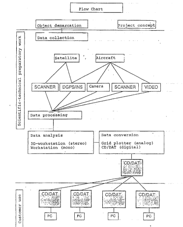
The invention will be described in conjunction with
a Fig. 1, which shows the seguence of the method;
a Fig. 2, which shows the instrumental configuration;
and
Fig. 3, which schematically ~Ypl~inc the method.
~ he exemplary em~odiment involves a topographic region
that is collected, analy2ed, measured and stored by the
method.
~ he method shown in Figs. 1 and 2 for collection,
analysis, measurement and storage of geographical data
includes the stages of object demarcation, data ac~uisition,
data processing, data analysis, and data conversion; the
~l~n~.~~ tals of the method are aerial pictures as well as
satellite recordings, geodetic information and other plAnn;ng
data; in short, three-dimensionally related items of
information that are linked together in the object space and
processed with the most modern computer and data processing
e~uipment configuration. For planning with and using a
Geographic Information System, which is what is primarily
addressed here, the following method steps are n~r~cq~ry:
1. Geographic demarcation of the project region to be
recordea and processed, using existing maps, analog or
digital information, or site descriptions.
2. Ac~uisition of geographic or cartesian coordinates,
if they are defined in national or supranational grids. In
the event that such information is unavailable, then
corresponding grids should be prepared, using satellite
geodetics with the global positioning system and optionally
e~n~n~fl by aerial triangulation.
3. The project region is recorded with high-
performance precision aerial survey cameras from the
aircraft: the picture material produced must completely cover
the region, and it must be assured that observation can be
~ 2 1 9 1 9~4
WO 95/3397~ ~ ~ ~ PCT/DE 95/00639
done stereoscopically. Care must be taken to assure a
geodetic inclusion of possible control points selected in the
project region.
4. In the event that qualitatively usa'ole satellite
image recordings are present, and the later wor~ scale allows
the use of the satellite images, then the geographic Pnrorl;ng
of the satellite xecoraings must be assured via control
points (x, y, z).
~ . ~he method contemplates the possibilities of using
inertizl-based D&PS positioning of the camera during the
picture-taking flight, in which case the expense for the
accomrlichr~nts in paragraph 2 can be reduced.
6. The analog picture material, after being developed,
is scanned with high resolution and thus converted into
digital information, with a precision in the submicrometer
range and with a resolution suitable for the stated ob3 ect.
7. The geographic r~n~n~;ng of the satellite rPcnr~;ngs
and aeri~l triangula~tion in position and altitude (x, y, z)
make it pncc;hle to survey every individual aerial image
molel or the satellite images. ~his procedure is an
important provision for incorporating the picture material
into the geodetic or geographic grids and hence is a basis
for further qualitative measurement and interpretation.
8. On the basis oP the data acquired in paragraph 6, a
digital altitude model iB measured or automatically computed,
and this in turn is the prereguisite for the difPerential
distortion correction of the aerial images~ With the
differential distortio~ correction of the digitally available
aerial image information, every pixel is in the form of a
parallel projection and is thus linked with the subsequent
digital image values to produce a digital orthophoto map.
9. By proceeding in steps 1-7, the project region is
made availaole to the data user in the form of a digital
~ .
~ 2191954
wo 95/33973 ~C~t~E 95/00639
model in the measuring laboratory ~workstation). Depending
on the particular ~rAw~r~ and software ùsed, he has the
capability of observing the terrain in parallel projection or
three-dimensionally ~plastically) and to measure and plan
therein.
The digital terrain information (see method steps 1-8)
is stored on suitable data media, with a compass a~forded to
the pro~ect region or the intended planning worX. Examples
of suitable data media are CDs. These data are offered to
potential users, unless a special proiect region is involved,
in the usual geographical association for instance on the
scale of a country or state, province, district, or
community. Thus each user of these digital data has the
capability, depending on his experience, instructions or job,
Or performing interactive rl~nn~ng or tasking third parties
to perform it. This makes consistent construction of
surfaces possible by way of lines; points, measurement
numbers and mathematical va]ues (such as tracings).
Xoreover, by interpretation, types of use, structural forms,
ecological factors, ~n~ , and other elements can be
detected at the same time and incorporated into the prepared
interactive data stock. In ~urther development, the method
also contemplates the three-dimensional incorporation of
constructions, for instance in road and bridge building, or
in building construction.
lO. ~he interactive construc~ion or planning in the
terrain model at the CAD workstation includes the use of
additional external, graphic and nongraphic information.
~his requires that the aforementioned information relative to
pl~nning be available in the same kind of geodetic or
geographic grid that is binding for the terrain model.
ll. ~he information in step lO can al~o be considered
a component of the method itself, because it must be produced
21 ql 95~
WO 95/~3973 PCT/DE 95/OOo~9
or ac~uired in a way that fits the course of the method.
~oreover, with existing measurement results from field
recordings, mathematically calculated values can be processed
in the terrain model at the interactive station. The
prerequisite for the linkage of grid and vector information
is a uni~orm geodetic reference system.
12. The technical eguipment part of data production
contemplates high-perf~7rr-r~ picture-taking aircraft,
er~uipped with high-resolution aerial survey cameras, GPS
navigation, ana optionally INS-D&P~ navigation, and moreover
makes it possible to ac~uire geographical data and
specifically allows the use Or satellite data or aircraft-
based sensor systems. ~or further pro~r~q;ng, high-quality
photographic laboratories of the usual scope must be used,
unless the aircraft-based data recording of the project
region is already done digitally at a later time. For high-
resolution d7gitizing o~ the panchromatic picture
information, suitable scanners are used. Aerial
triangulation or other geodetically sa~;cfA~tnry fit point
~r~nr~r~nc~nrJ and the production of digital altitude models are
done using high-performance picture processing systems. rrhe
storage of the distortion-corrected digital terrain model is
aOne with the three-dimensional reference mentioned in
paragraph 9.
13. At the same time, taking conventional industrial
exchange ~ormats into account, it is assu~ed with the method
that the digital picture data, vector data and ~lphAnll~erical
information are kept compatible with mani~old data bases and
data formats. It is also provided as needed that the data o~
parts thereof be transmitted by telemetry, E-mail, ISDN, and
the like, with adequate fees being chargea.
14. The method is oriented to a commercial production
strategy aimed at a potentially existing market, and it can
: -
- ~ 21 9t 954
WO 95/33973 PCT/DE 95/00639
be modified constantly and adapted as technology progresses.
Basic software for visual display of the in~ormation is
included.
In Fig. 3, the method is schematically shown in such a
way that a topographical area (region~ 1 is recorded by
aerial picture taking by means of aircraft 2, whose location
in space is positioned by satellites 3 with the aid of their
signals (DGPS), then the digital altitude model 4 in
a~o~r~no~ with method step 4 is derived as data ana~ysis or
available in calculated form; from the topographical area
(region) 1 and the digital altitude model 4, inc~ ;ng the
known location of the project centers in space at the time o~
recording by the aircra~t 2/ and by means of mathematical
trans~ormation of the analog aerial picture or o~ a digital
aerial picture~scene, the digital orthophoto 5 is produced,
which is made available to the potential user by means of
data media; thus it becomes possible ~or the potential user,
depending on his assigned task and requisite decision making,
which he, as a customer, has formulated, to add a vector,
line graphic 6 to the digital orthophoto 5 and analyze it
correspondingly use~ully.
~ 21 91 954
~O 95/33973 PCT/DE 95/00639
Reference n~mera~s used
1 topographical area tregion)
2 aircraft
3 satellites
4 digital altitude model
digital orthophoto
6 vector, line graphic
.
.