Note: Descriptions are shown in the official language in which they were submitted.
CA 02206963 1997-06-04
METHOD AND APPARATUS FOR NAVIGATING A REMOTELY GUIDED
BRUSH CUTTING, CHIPPING AND CLEARING APPARATUS
FIELD OF THE INVENTION
The present invention relates generally to a method and apparatus
5 for navigating a vehicle. Specifically, the present invention relates to a
method and apparatus for navigating a remotely guided brush cutting,
chipping and clearing apparatus, dependent upon remote positioning data,
having a locator system for determining a location of the apparatus and a
guidance system to achieve and m~int~in a desired direction of travel,
10 including a method for navigating a specific line of travel and a plurality of
particular points along the line of travel, by the apparatus, relative to the
surface of the earth.
BACKGROUND OF THE INVENTION
The ability to quickly and accurately navigate through and traverse
5 over lightly to moderately wooded and/or thicketed terrain, along
particular points of a specific line of travel, without the assistance of
conventional land-based survey techniques and crew, and in the absence of
permanently ~l~m~ging the land, is of significant importance. Presently it
is a difficult task to clear small to moderate sized brush consisting of small
20 trees having diameters of up to 5 inches, thick briar patches, overgrown
vines, grasses and weeds, all in an effort to accurately locate and travel a
desired line of travel and a plurality of specific points along that line.
Often, the desired path or line of travel may, for example, include
property lines, seismic lines, rights-of-way and the like. Even where the
-2-
CA 02206963 1997-06-04
survey coordinates, longitude and latitude coordinates or other types of
location data are known for the specific property line, seismic line or
right-of-way, brush and overgrown vegetation present significant barriers
to physically locating these pathways. Various types of soil cl~m~ging
5 equipment such as bulldozers, road scrapers and other types of heavy
equipment may be used to knock down and push aside brush, however the
soil ~l~m~ge incurred to the land generally outweighs the benefit of using
this type of equipment. In the past, the location and clearing of property
lines, seismic lines, rights-of-way and the like, in lightly to moderately
10 wooded and/or thicketed areas has generally required a surveyor and a lead
survey crew to begin at a known location and slowly and methodically hand
cut its path and measure the appropriate distance in the desired direction to
locate property lines, seismic lines, rights-of-way and the like, while a
brush clearing crew and/or a brush clearing device follow behind the
15 surveyor. Although this procedure for identifying property lines, seismic
lines, rights-of-way and the like is generally accurate, it is nonetheless,
very slow, labor intensive and expensive.
It would be of great benefit to not only be able to quickly and
accurately navigate through and traverse over lightly to moderately
20 wooded and thicketed terrain, but, at the same time to be able to locate a
desired direction of travel and a plurality of specific points along the line
of travel, and clear a pathway through the wooded and thicketed areas to
provide easy access for motorized and/or foot traffic through said pathway.
Heretofore, there have been no methods of navigating which
25 integrate an apparatus locator system, an apparatus guidance system, and a
navigation system, with a brush cutting, chipping and clearing apparatus,
which provides for navigating a remotely guided brush cutting, chipping
and clearino apparatus over property lines, seismic lines, rights-of-way and
-3 -
CA 02206963 1997-06-04
the like, while clearing a pathway for motorized and/or foot traffic,
without the need for traditional survey procedures. For the apparatus
locator system to be effective throughout the world, it would need to be
dependent on a satellite guidance system. One apparatus locator system
5 may include, for example, communications equipment which could receive
signals from the Global Positioning System (GPS) satellite network. A
detailed explanation of the Global Positioning System is set forth in U.S.
Patent No. 5,155,490, GEODETIC SURVEYING SYSTEM USING
MULTlPLE GPS BASE STATIONS, issued to Spradley, Jr. et al. The
10 GPS satellite network comprises 24 satellites which produce positioning
signals and provide for the calculation of distance measurements. A
minimum of three GPS satellite signals are necessary to determine any
position on the earth. The GPS satellite signals can be received by one or
more base stations, located at various positions on the earth's surface, and
15 by a GPS antenna which may be mounted to the apparatus. The base
station may receive and interpret the GPS satellite signals, however the
base station produces a differential correction signal for use with the GPS
satellite signals. The base station in turn sends the differential correction
signal to a communication satellite which conveys the differential
20 correction signal to a radio antenna mounted to the apparatus, or
alternatively, the radio antenna may receive the differential correction
signal directly from the base station. Additionally, a dual purpose antenna
can receive both the GPS satellite signals and the differential correction
signal from the base station. The differential correction signal and the GPS
25 satellite signals can be simultaneously interpreted by the guidance system,
wherein the differential correction is applied to calculate the current
position of the vehicle from the GPS satellite signals. The corrected
position and location of the apparatus, with respect to the earth and the
-4-
CA 02206963 1997-06-04
desired direction of travel, can then both be displayed by the guidance
system, in selectively either a graphic manner or a digital manner. An
operator, stationed on board the apparatus or remotely stationed from the
apparatus but having access to the guidance system, could view the
5 guidance system and in response thereto maneuver the apparatus to cut,
chip and clear small to moderately sized brush while traveling in a desired
direction, i.e. over property lines, seismic lines, rights-of-way and the like.
The GPS satellite signals provide very accurate guidance information
where they can be received and where the positioning signal can be
10 conveyed to the receiver antenna. However, in thickly forested areas or
other areas having dense overhead or "canopy" cover, the GPS satellite
signals may not always be effectively received. Thus the need arises for
alternate apparatus locator systems which can be used in areas having
canopy cover. An alternate apparatus locator system which may be used in
15 areas having canopy cover may include, for example, an automated or
semi-automated geodetic survey system, independent of guidance satellite
signals. One such semi-automated geodetic survey system, may, for
instance comprise the Geodimeter@~ System 4000. The Geodimeter(~)
System 4000 is an automated survey system consisting of a transportable
20 station unit positioned at a known point and a mobile reflector, generally
mounted to a transportable carrier or vehicle. The station unit
continuously conveys laser signals to the reflector, as the reflector moves
away from the station unit. The laser signals are then reflected back to the
station unit and measurement data is collected by a guidance system which
25 may for example be a control unit or data processor which may be affixed
adjacent to the reflector. The laser signals are processed at the station unit
and a radio signal is sent to the guidance system. The radio signal is
processed by and displayed by the guidance system, thus informing the
-5-
CA 02206963 1997-06-04
operator as to the present location of the apparatus and the desired
direction of travel.
Therefore, a need exists for a method of navigating a remotely
guided brush cutting, chipping and clearing apparatus having a locator
S system for determining the location of the apparatus and a guidance system
for determining the desired direction of travel for the apparatus and for
navigating along specific points of a particular line of travel, relative to thesurface of the earth. Additionally, a need exists for a method of logging or
recording the points traversed by the apparatus, of the line of travel,
10 relative to the surface of the earth.
Although the need for such a device and method of navigating has
been lorlg felt, the prior art, heretofore, has not provided such a device or
method which meet all of the aforementioned criterion.
Additional features and advantages of the invention will be set forth
15 in part in the description which follows, and in part will become apparent
from the description, or may be learned by practice of the invention. The
features and advantages of the invention may be realized by means of the
combinations and steps particularly pointed out in the appended claims.
- SUMMARY OF THE INVENTION
To achieve the foregoing objects, features and advantages in
accordance with the purpose of the invention as embodied and broadly
described -herein, a method for navigating a remotely guided brush cutting,
chipping and clearing apparatus, dependent upon remote positioning data
and radio communication signals, is presented to quickly and accurately
navigate through and traverse over lightly to moderately wooded and
thicketed terrain,- along specific points of a particular line of travel, while
at the same time clearing a pathway through the wooded and thicketed
-6-
CA 02206963 1997-06-04
areas to provide passage for motorized and/or foot traffic through said
pathway. The present invention provides a preferred embodiment method
for remotely guiding a brush cutting, chipping and clearing apparatus
consisting of a vehicle; a cutting head mounted to said vehicle for cutting,
5 chipping and clearing brush; an apparatus locator system mounted to the
vehicle for to determine the location of the apparatus with respect to the
surface of the earth which receives the remote positioning data and radio
communication signals; and a guidance system in signal communication
with the apparatus locator system to process the remote positioning data
10 and radio communication signals to navigate the apparatus in a desired
direction of travel. The cutting head preferably includes a plurality of
pivotal, U-shaped, throw-out knives mounted to a rotatable, horizontal
shaft and a drive means for rotating the horizontal shaft. The guidance
system may for example be a data processor and a navigation system,
15 wherein the data processor includes a central processing unit and display
unit for processing the remote positioning data, the radio communication
sigr~ls and the survey coordinates of a desired or pre-determined direction
of travel, including, for example, the survey coordinates for property
lines, seismic lines, rights-of-way and the like. The guidance system may
20 also include a video display screen for displaying to an operator the
processed data, including the current position of the apparatus relative to
the surface of the earth, and the desired direction of travel for the
apparatus. The apparatus locator system may include, for instance, a GPS
signal processing unit and one or more satellite/radio communication
25 antenna or, alternatively a dual purpose antenna for receiving a plurality ofremote positioning data signals produced from a guidance satellite system.
The satellite/radio communication antenna or dual purpose antenna may
also receive a differential correction signal generated from a base station.
-7-
CA 02206963 1997-06-04
The base station may, for example, be a conventional GPS base station.
The base station may also be in communication with the remote positioning
data signals produced by the guidance satellite system. The one or more
satellite/radio communication antenna is preferably mounted to the vehicle
5 and connected to a GPS signal processing unit via a first coaxial
communication link. The GPS signal processing unit is also preferably in
direct communication with the guidance system via a second coaxial
communication link. The guidance satellite system may include any of the
public access satellite systems, such as, for example the Coast Guard
10 satellite guidance system. The guidance satellite system may also include
any commercial or private satellite systems, such as for instance, the Omni-
Star satellite guidance system. The base station may, for example, be a
Coast Guard operated facility or may be privately operated, wherein users
pay for the differential correction signal broadcast.
Alternatively, the apparatus locator system may include
communication equipment in communication with an automated or semi-
automated geodetic survey system. The alternate embodiment apparatus
locator system may include for example a ~lrst communication antenna
mounted to the apparatus. The geodetic survey system may further
20 include, for example, a station unit and a reflector. The reflector is
typically mounted to the apparatus or some other object which generally
moves away from the station unit. The station unit may transmit a
continuous laser signal or other type of signal to the reflector, wherein the
reflector returns the signal back to the station unit. The station unit
25 processes the reflected laser signal and, in response thereto, produces and
transmits remote positioning data in the form of a radio signal to the
guidance system. The guidance system may, for instance, be a data
processor or control unit having a central processing unit and a visual
-8-
CA 02206963 1997-06-04
display, which is mounted on the apparatus. The radio signal generated
from the station unit contains location and positioning information
regarding the reflector which is mounted to the apparatus. The guidance
system processes the radio signal, determines the location of the apparatus,
S displays the location of the apparatus and the desired direction of travel for
the apparatus.
The present invention includes a method for remotely guiding a
brush cutting, chipping and clearing apparatus, dependent upon remote
positioning data and radio communication signals, the method preferably
10 includes the steps of: receiving by an apparatus locator system, the remote
positioning data and radio communication signals; conveying the remote
positioning data and radio communication signals from the apparatus
locator system to a guidance system; processing and displaying by the
guidance system, the remote positioning data and radio communication
15 signals transmitted from the apparatus locator system; interpreting, by an
operator, the data processed by the guidance system to determine a current
location of the apparatus with respect to the surface of the earth; and
maneuvering of the apparatus by the operator, to guide the apparatus in a
desired direction of travel.
Additionally, the present invention includes a method of navigating a
vehicle, preferably comprising a remotely guided brush cutting, chipping
and clearing apparatus, dependent upon remote positioning data and radio
communication signals, along specific data points of a particular line of
travel, and includes the steps of: engaging a data processor and navigation
system, mounted on the vehicle, wherein the data processor includes a
video data display and is in communication with the remote positioning
data and radio communication signals; selecting on the data processor and
navigation system, a particular line of travel along which to navigate the
g
CA 02206963 1997-06-04
vehicle; inputting in to the data processor and navigation system, a starting
line of travel, a specific starting point on the particular starting line of
travel from which to begin navigating the vehicle, a specific ending point
on the particular starting line of travel and a plurality of data points on the
5 starting line of travel between the specific starting point and the specific
ending point; selecting from the data processor, a visual display format
from which an operator of the vehicle can interpret the instantaneous
position of the vehicle, a particular line of travel and a plurality of specificdata points, in relation to the surface of the earth and thereafter control the
10 navigation of the vehicle; navigating the vehicle along the plurality of datapoints on the particular line of travel; and selectively providing for the
input of additional lines of travel and additional specific data points along
the additional lines of travel, to allow the vehicle to navigate a plurality of
lines of travel.
BRIEF DESCRIPTION OF THE DRAWINGS
The accompanying drawings which are incorporated into and
constitute a part of this specification, illustrate a preferred embodiment of
the invention and together with a general description of the invention given
above and-the detailed description of the preferred embodiment given
20 below serve to explain the principals of the invention.
FIG. 1 is a perspective view of a remotely guided brush cutting,
chipping and clearing apparatus embodying the concepts of the present
mvention.
FIG 2A is a front view of a preferred embodiment cuttin~, head of
25 the present invention shown in FIG. 1.
FIG. 2B is a partial cut-away, perspective view of the cutting head
shown in FIG. 2A.
-10- . -
CA 02206963 1997-06-04
FIG. 3 is a pictorial representation illustrating the operation of the
preferred embodiment of the present invention as shown in FIG. 1.
FIG. 3A is a pictorial representation illustrating the operation of an
alternate embodiment of the present invention.
S ~IG. 4 is detailed side view of a cab interior of the preferred
embodiment of the present invention, illustrating the placement of the
guidance system.
FIG. S is a schematic diagram illustrating the operation and
relationship between the first satellite antenna, the preferred embodiment
10 guidance system and the second communication antenna of the present
nvention.
FIG. 6 is a pictorial representation illustrating the operation of an
alternate embodiment of the present invention utili7ing a geodetic survey
apparatus locator system.
FIG. 7 is a block diagram depicting a preferred method of remotely
guiding a brush cutting, chipping and clearing apparatus.
FIG. 8 is a block diagr~m illustrating a preferred method of
navigating the remotely guided brush cutting, chipping and clearing
apparatus.
FIG. 9 is a block diagram illustrating a preferred method of logging
the specific data points of a particular line of travel, navigated by the
remotely guided brush cutting, chipping and clearing apparatus.
FIG. 10 is a top view, graphic representation of the vehicle
navigating along various lines of travel and a plurality of specific data
points located on the lines of travel.
The above general description and the following detailed description
are merely illustrative of the generic invention and additional modes,
CA 02206963 1997-06-04
advantages and particulars will be readily suggested to those skilled in the
art without departing from the spirit and the scope of the invention.
D~TAILED DESCRIPTION OF THE INVENTION
With reference to the drawings wherein like parts are designated by
S like numerals, FIG. 1 illustrates a perspective view of a preferred
embodiment remotely guided brush cutting, chipping and clearing
apparatus l 0, which is dependent upon remote positioning data and radio
communication signals, as defined by the present invention. The remotely
guided brush cutting, chipping and clearing apparatus 10 preferably
10 includes a vehicle 12; having three or more wheels 14; a cab 16 for
accommodating an operator (not shown), a steering control means 18 for
- controllably maneuvering the vehicle 12, a power control means 20; and a
cutting or cutter head 22 mounted to the vehicle 12 for cutting, chipping
and clearing a pathway or particular line of travel 24 through an area of
15 small to moderately sized brush 26. The cutter head 22 is mounted to the
vehicle 12 via a hydraulic support system 28 which selectively raises and
lowers the height of the cutter he.ad 22. The cutter head 22 includes a
housing 3 0 within which is secured a rotatable, horizontal shaft 3 2. The
hydraulic support system 28 also provides rotational drive power for the
20 horizontal shaft 3 2.
With reference to FIGS. 1, 2A and 2B, a plurality of U-shaped
throw-out knives 34 are shown mounted to a peripheral edge of a plurality
of mounting discs 3 6. The mounting discs 3 6 are laterally mounted on and
rotated by the rotatable, horizontal shaft 32. The plurality of throw-out
25 knives 34 are pivotally affixed to a plurality of mounting discs 36 such
that when the shaft 32 is rotated at high revolutions per minute, such as,
for example, 60 rpm, the throw-out knives 34 pivot outward from the
-12-
CA 02206963 1997-06-04
340 mounting discs 36 to extend a "trough" portion 38 having a very sharp
edge, wherein the sharp edged trough portions 38 cut, chip and clear the
brush 2 6. Additionally, the preferred embodiment cutter head 2 2 includes
one or more bumpers 40 which facilitate the feeding of small to medium
sized brush 26 into the cutter head 22 and the bumpers 40 also serve to
345 protect the cutting head 22 from unintentional contact with non-brush
related material (not shown).
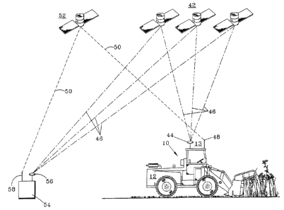
Referring now to F~G. 3, a pictorial representation illustrating the
operation of a preferred embodiment of the present invention ll~ili7.ing a
guidance satellite network 4 2 is depicted. The satellite network 4 2 used in
350 the preferred embodiment remotely guided, brush, cutting, chipping and
clearing~ apparatus 10 may, for example, be the Global Positioning System
(GPS) Network, consisting of 24 positioning satellites 4 2. In the preferred
embodiment remotely guided, brush, cutting, chipping and clearing
apparatus 10, the vehicle 12 has mounted thereto an apparatus locator
355 system 13 which includes a first satellite receiver antenna 4 4 for receiving
a plurality of satellite network signals 46, sometimes referred to as
"tracking" or remote positioning signals 4 6 and a second radio
communication antenna 4 8 for receiving a differential correction signal 5 0
which may be transmitted from a communication satellite S2. A single
360 base station 54 may also receive the plurality of satellite network signals
46 at a second satellite receiver antenna 56. The satellite network signals
46 may be received and processed at the base station 54 wherein a
differential correction signal 50 is produced. The differential correction
signal 5 0 may then be transmitted from a second radio antenna 5 8, located
365 at the base station 5 4 to the communication satellite S 2 for transmission to
the first radio antenna 48. Alternatively, the base station 54 may also
broadcast the differential correction signal 5 0 from the second radio
-13-
CA 02206963 1997-06-04
antenna S8 directly to the first radio antenna 48. With reference to FIG.
3A, where structure similar to that in FIG. 3 is similarly numbered, a dual
purpose antenna 45 may be mounted to the vehicle 12 in place of the first
satéllite receiver antenna 44 and second radio communication antenna 48,
5 to receive both the plurality of satellite network signals 4 G and the
differential correction signal 5 0. The dual purpose antenna 4 5 is
preferably in direct signal communication to a GPS signal processing unit
47, for example a Trimble~ signal receiver, model no. Ag 120, via a first
coaxial cable connection 4 9, which connects the dual purpose antenna 4 5 to
10 the GPS signal processing unit 47. Alternatively, an second alternate
embodiment apparatus locator system 11 can comprise the dual purpose
antenna 45 and the GPS signal processing unit 47. A second cable
connection 51 preferably engages the GPS signal processing unit 47 to a
data processing unit 63, which also preferably includes a video display.
15 The data processing unit 63 may for example be a COMPAQ~ lap top
computer, model no. Elite 4/50CX, which is mounted inside the cab 16 of
the vehicle 12 and easily accessible to the operator (not shown). The dual
purpose antenna 45 receives the plurality of satellite network signals 46
and the differential correction signal 50. These signals 46, 50 are in turn
20 conveyed along the first coaxial cable 49 to the GPS processing unit 47,
where the differential correction signal 50 is applied to the calculation of
position from the satellite network signals 46, to obtain a corrected actual
position of the vehicle 12, relative to the surface of the earth. The
corrected position is then relayed to the data processing unit/video display
25 unit 6~ via the second connection S 1, where the graphic location of the
vehicle 12 is displayed by the data processing unit/video display unit G3,
relative to a particular line of travel 24.
-1~
CA 02206963 1997-06-04
Referring now to FIGS.3,4 and 5 the differential correction signal
50 which is received by the first communication antenna 48 is conveyed to
a guidance system 61 mounted to the vehicle 12. The guidance system 61
may, for example, include a data processor 60 and a video display 62. A
5 quantity of data (not shown), including survey coordinates, longitude and
latitude coordinates or other survey information describing the desired
direction of travel, including property lines, seismic lines, rights-of-way
and the like, is preferably input into the data processor 60 and can be
viewed on the video display 62. In the preferred embodiment, the data
10 processor 60 may be an on-board central processing unit or personal
computer, powered by the DC electrical system of the vehicle 12 (not
shown). The first satellite receiver antenna 44 receives the satellite
network signals 46 and conveys the signals 46 to the video display 62.
The video display 62 may also preferably be powered by the DC electrical
15 system of the vehicle 12 (not shown). The video display 62 then conveys
the satellite network signals 46 to the data processor 60, wherein the
satellite network signals 46 are corrected using the differential correction
signal 50. The data processor 60 then transmits the corrected network
signals 46 back to the video display 62, wherein the location of the vehicle
20 12, relative to the surface of the earth, is displayed on the video display 62
and, additionally the desired direction of travel of the vehicle 12 relative to
the survey coordinates of the property line, seismic line, right-of-way and
the like, may also be displayed on the video display 62. The satellite
network signals 46 and the differential correction signal 50 are preferably
25 communicated over a length of coaxial cable 64 disposed between and
engaging the first satellite antenna 44 and the first communication antenna
48 to the guidance system 61.
-15-
CA 02206963 1997-06-04
With reference now to FIGS. 3, 3A, 4 and 5, the operator (not
shown) can view the video display 6 2 or data processor video display 6 3 to
determine the location of the vehicle 12 and can simultaneously make
steering corrections, via the steering means 18, to maneuver the vehicle 12
5 to achieve and maintain the desired direction of travel. In this manner, the
vehicle 12 is remotely guided using the satellite network signals 46 and the
differential correction signal 50 to precisely travel in a desired direction,
easily loc~ting intangible boundaries and paths such as property lines,
seismic lines, rights-of-way and the like while cutting, chipping and
10 clearing brush, in the absence of using slow, labor intensive and expensive
traditional surveying methods and in the absence of creating permanent
environrnental and soil erosion concerns.
The above described guidance satellite system 42 yields extremely
accurate remote positioning data where the satellite network signals 46 can
15 be received by the satellite receiver antennae 44, 56 and where the
differential correction signal 5 0 can be relayed to the first communication
antenna 48. However, in areas where the satellite network signals 46 can
not be received, such as for example in areas where there is a thick
vegetation "canopy," i.e. swamps, jungles and thick forests, an alternative
20 apparatus locator system must be employed to remotely guide the brush
cutting, chipping and clearing apparatus 10.
With reference now to FIG. 6, an alternate embodiment apparatus
locator system 7 0 for remotely guiding an apparatus 10, dependent upon
remote positioning data and radio communication signals, for cutting,
25 chipping and clearing brush is depicted. The alternate embodiment
apparatus locator system 7 0, may for example be a semi-automated
geodetic survey system 71. The semi-automated geodetic survey system
71 may, for example, may be a Geodimeter~) System 4000 geodetic survey
-16-
CA 02206963 1997-06-04
system. The preferred embodiment semi-automated survey system 71,
preferably consists of a transportable station unit 72, positioned at a known
point 74 and a mobile reflector 76, preferably mounted to the apparatus
10. A guidance system 78, having an internal data processor, a video
5 display and a first radio antenna (not shown) is also mounted to the
apparatus 10 and is in signal communication with the station unit 72. The
station unit 72 continuously conveys a laser signal 80 to the reflector 76.
The laser signal 80 is then reflected back to the station unit 72 and
measurement data is obtained from the reflected laser signal 80 and is
10 collected at the station unit 72. The guidance system 78, may preferably
be affixed directly to the reflector 76 or may be mounted adjacent to the
reflector 76. The reflector 76 may be affixed to a movable object such ~
the apparatus 10 or a hand held rod (not shown). The laser signal 80 is
processed at the station unit 72, wherein a radio signal 82, containing the
15 measurement information is created. The radio signal 82 is broadcast
from a first- radio antenna 84 to a second radio antenna 86 which is in
com~ull~ication with the guidance system 78. The radio signal 82 is
processed by the guidance system 78, wherein the apparatus 10 location
and the desired direction of travel is visually displayed by the guidance
20 system 78 thus informing the operator (not shown) as to the location of the
apparatus 10 with respect to the surface of the earth and illustrating the
desired direction of travel.
With reference to FIG. 7, a block diagram depicting a preferred
method for using the remotely guided brush cutting, chipping and clearing
25 apparatus 10, dependent upon remote positioning data and radio
communication signals, having an apparatus locator system 13, 70 for
determining the location of the apparatus 10 and the desired direction of
travel for the apparatus 10, relative to the surface of the earth is presented.
-17-
CA 02206963 1997-06-04
The method preferably includes the steps of: receiving 10 0 by an
apparatus locator system 1 1, 13, 7 0 the remote positioning data 4 6t 8 0
and radio communication signals 50; conveying 200 the remote
positioning d~ta 46, 80 and radio communication signals 50 to a guidance
5 system 59, 61, 78; processing and displaying 300 by the guidance system
5 9, 6 1, 7 8 the remote positioning data 46, 8 0 and radio communication
signals 50 transmitted from the apparatus locator system 11, 13, 70;
interpreting 400, by an operator (not shown), the data processed by the
guidance system 5 9, 6 1, 7 8 to determine a current location of the
10 apparatus 10 with respect to the surface of the earth; and maneuvering ~00
the apparatus 10, by the operator, to guide the apparatus 10 in a desired
direction of travel.
With reference generally to FIGS. 1-7, and speci~lcally to FIGS. 8
and 10, structure in FIGS. 8 and 10 which is similar to structure in FIGS.
15 1-7 is similarly numbered, a preferred method 600 for navigating the
apparatus 10 along exact points 101, 102, 103, 104, 10S, 106, 107 of a
particular line of travel 24, is illustrated. As discussed above, the data
processor 63, 60 is preferably mounted on the apparatus 10 and is in
electrical communication with, and empowered by, an on board power
20 source (not shown) which provides energy to propel the apparatus 10. The
data processor 63, 60 also preferably includes a navigation system 600,
which may for ex~mple be navigational software which interfaces with the
GPS navigational satellite network 42. A second alternate embodiment
apparatus guidance system 59 may comprise the data processor video
25 display 63 and the navi~,ational system 600 contained within the data
processor video display 63. By way of example, the navigation system
600 may comprise navigational computer software licensed and distributed
by Terra Services, Inc., under the GATOR-TRACSM service mark. When
-18-
CA 02206963 1997-06-04
the s;gnal processing unit 4 7, the dual purpose antenna 4 5, the data
processor 63, 60 is switched on or engaged 602, the navigational system
600 becomes accessible to the operator (not shown) and a variety of initial
messages may be displayed on the data processor 63, 60. The initial
S messages displayed on the data processor 63, 60 may include, but are not
limited to, identifying the serial port (not shown) which is currently in use
by the data processor 63, 60, and may also illustrate a menu (not shown)
of the various functions of the navigation system 600. Next, a fixing
function 604 of the navigation system 600 is activated to determine an
10 initial point number 101 on the initial line of travel 24, to determine the
present location of the apparatus. The fixing function 604 performs the
step of searching for the next point number 102 along the line of travel
24 to maintain a planned or sequential progression along the line of travel
2 4. The fixing function 60 4 can determine the navigational coordinates of
15 the apparatus and/or beginning navigation position in terms of the
particular line number and specific point number, i.e., line number 24,
point number 101 (024101); latitude and longitude coordinates (not
shown); and/or easting and northing coordinates (not shown). Preferably,
the navigational coordinates are in a format consistent with the North
20 American Dimension (NAD) 27 State Plane Grid, which is recognized as
an accepted standard in the seismic and navigation industry. Additionally,
the line nurnber of the particular line of travel 24 and specific point
numbers 101, 102, 103, 104, 105, 106, 107 along the line of travel 24
to be traversed by the apparatus 10, are preferably provided in a particular
25 fo~nat known in the seismic industry as a "SEG Pl" file (not shown).
"SEG" is an abbreviation derived from the term "Society of Exploration
Geophysicists." The SEG P1 file (not shown) consists of a specific set of
navigation coordinates to be traversed by the apparatus 10, which are
-19-
CA 02206963 1997-06-04
arranged in an industry standard digital, columnar manner, which can be
uniformly down loaded into the data processor 6 3, 6 0 to easily interface
with the navigation system 600. The SEG P1 file (not shown) generally
provides specific navigation information for the particular line of travel 24
5 andthespecificdatapointnumbers 101, 102, 103, 104, 105, 106, 107
along the particular line of travel 2 4, the longitude and latitude
coordin~tçs, and the easting and northing coordinates to be traversed by the
apparatus 10. The SEG P1 file (not shown) is preferably down loaded into
the data processor 63, 60 prior to commencing the navigation system 600.
10 After the fixing function 604 has been engaged, a logging or recording
function 606 may selectively be activated. Activation of the logging
function 606 records the location of the data points 101, 102, 103, 104,
105, 106, 107 along the particular line 24 traversed by the apparatus 10,
for the purpose of constructing a map or plot 29, illustrated in FIG. 10, of
15 the points 101, 102, 103, 104, 105, 106, 107 traversed by the apparatus
10. The logging function 606 will be discussed below in reference to FIG.
8. After deciding whether to activate the logging function 606, a decision
step 608 must be made whether to navigate the apparatus 10 along an
established or previously computed line 24 previously entered into the data
20 processor 63, 60, or to construct a new line 25 using the information
contained in the SEG P1 file or from coordinates in the data processor 6 3,
60. If navigation of the apparatus 10 is to take place along a previously
established line of travel 24, the operator (not shown) inputs a selection
accordingly into the data processor 63, 60. Alternatively, the operator
25 (not shown) may select, using the data processor 63, 60, to construct or
build a new line of travel 25. If the operator (not shown) selects 610 an
established line of travel 24 to navigate along, the operator (not shown)
enters the particular line number 24. The operator (not shown) thereafter
-20-
CA 02206963 1997-06-04
selects a navigational format 612 to be displayed on the video display 62
and/or the data processor 63. The operator (not shown) may select either
a graphic representation similar to that shown in FIG. 10, where the
apparatus 10 is displayed along the line of travel 24, wherein travel along
S the line of travel 24 and divergence from the line of travel 24 is depicted
in a pictorial format, or the operator (not shown) may select a digital
format (not shown) which displays numerical distance measurements
between specific points 101,102,103,104,105,106, 107 along the line
of travel 24 and numerical distance measurements between the apparatus
10 10 and the line of travel 24 in generally accepted units of measurement,
i.e. linear feet, yards, meters, etc. Once the navigational format G12 has
been chosen, the operator (not shown) navigates 614 along the particular
lineoftravel24andspecificpoints101, 102, 103, 104, 105, 106, 107
along the line of travel 24. At the completion of the navigation step 614,
15 the operator (not shown) may selectively navigate 616 another line of
travel 25 or end navigation operations 618. If at the decision step 608,
the operator (not shown) decides to build a new line of travel 25, the
operator (not shown) must select a navigation format 620 of either a
digital or graphic display, as previously explained at step 612. After the
20 navigation format is selected in step 620, the operator (not shown) is asked
622 whether the new line of travel 25 to be traversed is the first line
constructed since the navigation system 600 has become engaged 602.
Step 622 decides whether to engage a swapping function 624 used to assist
in navigating a secondary or additional lines of travel (not shown). If at
25 step 622, the operator (not shown) is then navigating a second or later line
of travel 25 with respect to step 602, the swapping function 624 can be
engaged and the last point 107 traversed on the previous line of travel 24,
now becomes the starting point 107 in the new line of travel 25.
-21 -
CA 02206963 1997-06-04
Additionally, when the swapping function 624 is engaged, the operator
(not shown) enters a new end point 202, and new line number 25, if
necessary, and navigation of the new line 25 takes place at step 614. If at
step 622, the operator (not shown) desires to construct and navigate a first
S line of travel 24 since the navigation system 600 was engaged at step 602,
the operator (not shown) enters the selection into the data processor 63,
60, accordingly. After the decision is made in step 622, the operator (not
shown) must again make a selection at step 626, whether to build a new
line of travel 27 from established points, not inclusive of the operator's
10 current position or build a new line 25 beginning from the operator's
current position and termin~ting at a new end point 202. Depending on
the operator's decision in step 626, the operator (not shown) may advance
to step 628 and enter an established start point 301 and line number 27
and an established stop point 305 and line number 27 to build a new line
15 27 separate from the present location of the apparatus 10. The operator
(not shown) then travels to the established start point 301 and traverses the
apparatus 10 along the new line of travel 27. Alternatively, the operator
(not shown) can proceed from step 626 to step 630 if the operator (not
shown) desires to begin navigation on a new line of travel 25 be~inning at
_
20 the current location 107 of the apparatus 10 and ending at a known end
point 202. In this manner, the operator (not shown) enters the location
coordinates of the present location of the apparatus 10 and the terminal
point 202 to be traversed and a new line 25 is graphically or digitally
displayed on the video display 62 and/or the data processor 63. At the
25 conclusion of step 628 and step 630, the line of travel 24 is then navigated
614 and the apparatus 10 generally traverses the line of travel 24 created
by the data processor 63, 60. At the conclusion of the navigation step
-22-
CA 02206963 1997-06-04
614, the operator (not shown) has the opportunity to navigate 616 an
additional line of travel 25,27 or to end 618 navigation operations.
Referring now to FIG. 9 and FIG. 10, the logging or data
recordation function 606 is illustrated in greater detail. As briefly
5 discussed above, the logging function 606 creates a data record (not
shown) of the navigational points 101, 102, 103, 104, lOS, 106, 107
and line of travel 24 actually traversed by the apparatus 10, which can be
used to create a map or plot 29 of the line 24 and data points 101, 102,
103,104,105,106,107 traversed by the apparatus 10. The data points
10 101, 102, 103, 104, 105, 106, 107 may for instance represent the
drillsite locations, shot or vibration locations, and/or the geophone
locations for use in seismic mapping. The map or plot 29 created by the
logging function 606 may also be used by planners and developers of the
land. The logging function 606, if engaged, allows the operator (not
15 shown) to record or log 700 the specific location of the data points 101,
102, 103, 104, 105, 106, 107 traversed along on the particular line of
travel 24 traversed by the apparatus 10, in selectively, fixed units of linear
measurement 702 between successive data points on the line of travel 24.
Alternatively, the operator (not shown) may record or log the data points
. _
20 101,102,103,104,105,106,107traversedalongthelineoftravel 24,
in a random manner according to the passage of fixed units of time 704
measured between successive data points 101, 102, 103, 104, 105, 106,
107 on the line of travel 24. The operator (not shown) in step 702 selects
the fixed linear measurement unit, i.e., feet, yards, meters, miles, etc., and
25 may also select the actual measured distance, i.e., 10 feet, 100 yards, 50
meters, etc., from the options menu of the navigation system 600 to ~e
measured between successive data points 101, 102, 103, 104, 105, 106,
107 along the line of travel 24. The operator (not shown) in step 704
-23 -
CA 02206963 1997-06-04
selects the specific unit of time measurement, i.e., second, minute, hour,
etc. and the specific time interval, i.e.,30 seconds, S minutes, 1 hour, etc.,
from the options menu of the navigational system 600, to record the time
interval which passes between random successive data points (not shown)
S traversed along a path (not shown) in a random manner. Having selected
the measurement format in step 702 or step 704, the operator (not shown)
engages the logging function 706 and begins recording the actual data
points 101,102, etc. traversed by the apparatus 10. After the logging or
recordation function 706 has commenced, the operator (not shown) may
10 preferably enter the name of the particular traversal 70X into the data
processor 60, to easily identify and access the recorded information. The
operator (not shown) and apparatus 10 then traverse 710 the particular
line or travel 24 to be logged as discussed in step 614, or FIG. 8, above.
The logging function 706 is disengaged 712 once the apparatus 10 has
lS completed traversing the data points 106, 107 of the particular line of
travel 24. After the logging operation 706 has become disengaged 712,
the operator (not shown) may log 714 an additional line of travel 25, 27
by returning to step 700, or can alternatively, down load 716 the logged
or recorded line(s) of travel 24 and data points 101,102,103, 104, 105,
20 106, 107 for use in creating a map or plot 29 of the area traveled or
covered by the apparatus 10.
It will be appreciated that these and other embodiments may be
provided to navigate a remotely guided brush cutting, chipping and
clearing apparatus, dependent upon remote positioning data and radio
25 communication signals, having an apparatus locator means for determinin~
the location of the apparatus and a guidance means for displaying the
desired direction of travel for the apparatus, relative to the surface of the
earth. Additional embodiments become readily apparent in view of the
-24
CA 02206963 1997-06-04
present invention as described herein above. Having described the
invention above various modifications of the techniques, procedures and
materials will be apparent to those skilled in the art. It is intended that all
such variations within the scope and spirit of the appended claims be
5 embraced thereby.
-25-