Note: Descriptions are shown in the official language in which they were submitted.
CA 02209177 1997-06-30
Wo 96/23290 PCTIUS~6l00S63
-1 -
AUTOl\~ATED LANE DEFINITION FOR
MACElINE VE;ION TRAFFIC DETECTOR
Field of the Invention
The present invention relates generally to systems used for trafflc detection,
monitoring, management, and vehicle classification and tracking. More particularly, this
invention relates to a method and apparatus for defining boundaries of the roadway and
the lanes therein from images provided by real-time video from machine vision.
Back roundoftheInvention
With the volume of vehicles using roadways today, traffic detection and
management has become ever important. Advanced traffic control technologies haveemployed m~çhine vision to improve the vehicle detection and hlfo~ Lion extraction at
a traffic scene over previous point detection technologies, such as loop detectors.
Machine vision systems typically consist of a video camera overlooking a section of the
roadway and a processor that processes the images received from the video camera.
The processor then detects the presence of a vehicle and extracts other traffic related
illrollll~lion from the video image.
An example of such a m~chine vision system is described in U.S. Patent No.
4,847,772 to Michalopoulos et al., and further described in Panos G. Michalopoulos,
Vehicle Detect~0~7 Video 77?ro7lgh In7age Processing: T*e Autoscope System, IEEETransactions on Vehicular Technology, Vol. 40, No. 1, February 1991. The
Michalopoulos et al. patent discloses a video detection system including a video camera
for providing a video image of the traffic scene, means for selecting a portion ofthe
Image for processing, and processor means for processing the selected portion of the
mage.
Before a m~r.hine vision system can perform any traffic management capabilities,the system must be able to detect vehicles within the video images. An example of a
m~chine vision system that can detect vehicles within the images is described incommonly-~signed U.S. Patent Application Serial No. 08/163,820 to Brady et al., filed
December 8, 1993, entitled "Method and Apparatus for Machine Vision Classification
and Tracking." The Brady et al. system detects and classifies vehicles in real-time from
images provided by video cameras overlooking a roadway scene. A~er images are
CA 02209177 1997-06-30
W 096/23290 PCTrUS96/00563
acquired in real-time by the video cameras, the processor performs edge element
detection, determining the magnitude of vertical and horizontal edge element intencities
for each pixel of the image. Then, a vector with m~gnitllde and angle is computed for
each pixel from the ho,i~ollLal and vertical edge element intensity data. Fuzzy set theory
is applied to the vectors in a region of interest to fuzzify the angle and location data, as
weighted by the m~gnit~lde of the inten~ities. Data from applying the fuzzy set theory is
used to create a single vector characterizing the entire region of interest. Finally, a
neural network analyzes the single vector and classifies the vehicle.
When m~c.hine vision systems analyze images, it is preferable to determine what
areas of the image contains the interesting information at a particular time. Bydiffer~.nti~ting between areas within the entire image, a portion of the image can be
analyzed to determine the importance of the information therein. One way to find the
interesting information is to divide the acquired image into regions and specific regions
of interest may be selected which meet predetermined criteria. In the traff~c
management context, another way to predetermine what areas of the image will usually
contain interesting information is to note where the roadway is in the image and where
the lane boundaries are within the roadway. Then, areas offthe roadway will usually
contain less information relevant to traffic management, except in extraordinarycircum~t~nces, such as vehicles going offthe road, at which time the areas offthe
roadway will contain the most relevant information. One way to delineate the roadway
in m~cchine. vision systems is to m~nll~lly place road markers on the edges ofthe
roadway. Then, a computer operator can enter the location of the markers on the
computer screen and store the locations to memory. This method, however, requires
considerable manual labor, and is particulàrly undesirable when there are large numbers
of in~t~ tions.
Another problem that machine vision systems face arises when attempting to
align consecutive regions of interest. Typically, translation variant representations of
regions of interest, or images, are acquired by the machine vision system. Therefore,
alignment of these translation variant representations can be difficult, particularly when
the detected or tracked object is not traveling in a straight line. When the edges ofthe
roadway and the lane boundaries are delineated, however, it f~çilit~tes ~lignmen~ of
consecutive regions of interest because when the tracked object is framed, it becomes
CA 02209177 1997-06-30
wo 96123290 PCTIUS96100563
more translationally invariant. In the traffic management context, regions can be
centered over the center of each lane to facilitate framing the vehicle within the regions,
thereby making the representations of the regions of interest more translationally
invariant.
Summary of the Invention
The present invention provides a method and system for autom~tic~lly cl~finin~
boundaries of a roadway and the lanes therein from images provided by real-time video.
A video camera provides images of a roadway and the vehicles traveling thereon.
Motion is detected within the images and a motion image is produced represçntin~ areas
where motion has been measured. Edge detection is performed in the motion image to
produce an edge image. Edges parallel to the motion of the vehicle are located within
the edge image and curves based on the parallel edges are generated, thereby d~?fining a
roadway or lane.
Brief Description of the Drawin s
The present invention will be more fillly described with reference to the
accompanying drawings wherein like reference numerals identify corresponding
components, and:
Figure 1 shows a perspectivc view of a roadway with a video camera acquiring
images for procç~ing,
Figure 2 is a flow diagram showing the steps of producing a curve definin~
boundaries of a roadway and lanes therein;
Figures 3a and 3b show raw images of a moving vehicle at a first time and a
second time;
Figure 3c shows a motion image derived from the images shown in Figures 3a
and 3b;
Figure 4 shows a 3 x 3 portion of a motion image;
Figures 5a and 5b show a top view and a side view of a Mexican Hat filter;
Figure 6 shows an edge image denved from the motion image shown in Figure
3c;
CA 02209177 1997-06-30
W O 96/23290 PCTrUS96/00563
Figure 7 shows a cross section across a row in the image, showing the intensity
for pixels in a column;
Figure 8 shows an image produced when images like the image in Figure 7 are
s--mmed over time;
S Figure 9 is used to show how to fix rows to produce points repres~ntin~ the
edge of the lane boundary; and
Figure 10 shows four points reprçs~nting the edge of the lane boundary and is
used to explain how tangents may be determined for piecewise cubic spline curve
interpolation.
Detailed Description of a Preferred Embodiment
In the following detailed description of the prefel 1 ed embodiment, reference is
made to the accompanying drawings which form a part hereof, and in which is shown by
way of illustration a specific embodiment in which the invention may be practiced. It is
to be understood that other embo-liment~ may be utilized and structural changes may be
made without departing from the scope of the present invention.
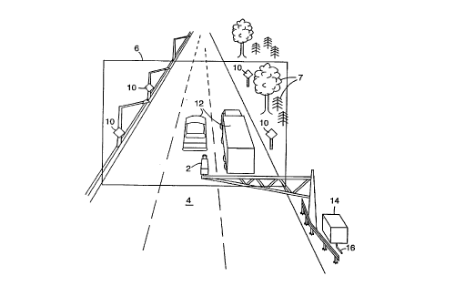
Figure 1 shows a typical roadway scene with vehicles 12 driving on roadway 4.
Along the side of roadway 4 are trees 7 and signs 10. Roadway 4 is monitored by a
machine vision system for traffic management purposes. The ~lncl~ment~l component of
information for a machine vision system is the image array provided by a video camera.
The machine vision system includes video camera 2 mounted above roadway 4 to
acquire images of a section of roadway 4 and vehicles 12 that drive along that section
roadway 4. Moreover, within the boundaries of image 6 acquired by video camera 2,
other objects are seen, such as signs 10 and trees 7. For traffic management purposes,
the portion of image 6 that includes roadway 4 typically will contain more interesting
information, more specifically, the information relating to the vehicles driving on the
roadway, and the portions of the image that does not include roadway 4 will contain less
interesting information, more specifically, information relating to the more static
background objects.
Video camera 2 is electrically coupled, such as by electrical or fiber optic cables,
to electronic processing or power equipment 14 located locally, and further may
transmit information along interconnection line 16 to a centralized location. Video
CA 02209177 1997-06-30
WO 96/23290 PCTIUS~GJCC''~
camera 2 can thereby send real-time video images to the centralized location for use
such as viewing, processing or storing. The image acquired by video camera 2 may be,
for example, a 512 x 512 pixel three color image array having an integer number
defining intensity with a definition range for each color of 0-2~5. Video camera 2 may
~ 5 acquire image illro,lllalion in the form of digitized data, as previously described, or in an
analog form. If image informàtion is acquired in analog form, a image preprocessor may
be inclu~led in processing equipment 14 to digitize the analog image information.
Figure 2 shows a method for determining the portion of the image in which the
roadway runs and for delinç~ting the lanes within the roadway in real-time. This method
analyzes real-time video over a period oftime to make the roadway and lane
determinations. In another embodiment, however, video of the roadway may be
acquired over a period of time and the analysis of the video may be performed at a
subsequent time. Referring to Figure 2, a~cer a first image is acquired at block 20 by
video camera 2, a second image is acquired at block 22. As earlier described, each
image is acquired in a digital format, or alternatively, in an analog format and converted
to a digital format, such as by an analog-to-digital converter.
As a sequence of images over time are acquired and analyzed, three variables
may be used to identify a particular pixel, two for identifying the location of the pixel
within an image array, namely (i, j), where i and j are the coordinates of the pixel within
the array, and the third being the time, t. The time can be measured in real-time or more
preferably, can be measured by the frame number of the acquired images. For a given
pixel- (i, j, t), a corresponding intensity, I(i, j, t), exists representing the intensity of a
pixel located at the space coordinates (i, j) in frame t, in one embodiment the intensity
value being an integer value between 0 and 255.
At block 24, the change in pixel intensities between the first image and second
image is measured, pixel-by-pixel, as a indication of change in position of objects from
the first image to the second image. While other methods may be used to detect or
measure motion, in a pl ~l l ed embodiment, motion is detected by analyzing the change
in position of the object. Figures 3a, 3b and 3c graphically show what change inposition is being measured by the system. Figure 3a depicts a first image acquired by the
system, the image showing vehicle 50 driving on roadway 52, and located at a first
position on roadway 52 at time t-l. Figure 3b depicts a second image acquired by the
CA 02209177 1997-06-30
W 096/23290 PCTrUS96/00563
system, the image showing vehicle ~0 driving on roadway 52, and located at a second
position on roadway 52 at time t. Because vehicle 50 has moved a distance between
times t-l and t, a change in position should be detected in two areas. Figure 3c depicts a
motion image, showing the areas where a change in pixel inten.ci~ies has been detected
between times t-1 and t, thereby inferring a change in position of vehicle 50. When
vehicle 50 moves forward in a short time interval, the back of the vehicle moves forward
and the change in pixel intensities, specifically from the vehicle's pixel intencities to the
background pixel inten.cities, infers that vehicle 50 has had a change in position, moving
forward a defined amount, which is represented in Figure 3c as first motion area 54.
The front of vehicle 50 also moves forward and the change in pixel intensities,
specifically from the background pixel intensities to the vehicle's pixel intto.ncities, also
infers that vehicle 50 has had a change in position, as shown in second motion area 56.
As can be seen in Figure 3c, the areas between first motion area 54 and second motion
area 56 have substantially no change in pixel intensities and therefore infers that there
has been subst~nti~lly no motion change. In a plerell~d embodiment, the motion image
may be determined by the following equation:
which is the partial derivative of the intensity function I(i, j, t) with respect to time, and
which may be calculated by taking the absolute value of the difference of the inten.cities
of the corresponding pixels of the first image and the second image. The absolute value
may be taken to measure positive changes in motion.
Referring back to Figure 2, at block 26, the motion image is analyzed to identify
edge elements within the motion image. An edge element represents the likelihood a
particular pixel lies on an edge. To determine the likelihood that a particular pixel lies
on an edge, the intensities of the pixels surrounding the pixel in question are analyzed.
In one embodiment, a three-dimensional array of edge element values make up an edge
image and are determined by the following equation:
E(i, j,t)_ 8Mf~i, j,t)- ~,M(i, j,t)
i+l,j+l
Figure 4 shows 3 x 3 portion 60 of a motion image. To determine E(i, j, t) for pixel (i,
j), the pixel intensity value of pixel in question 62 in the motion image M~i, j, t) is first
multiplied by eight. Then, the intensity value of each of the eight neighboring pixels is
CA 02209177 1997-06-30
WO 96/23290 PCTtUS96100563
subtracted from the multiplied value. Af'[er the eight subtractions, if pixel in question 62
is not on an edge, the intensity values of pixel 62 and its neighboring pixels are all
al~pro,sill,ately equal and the result of E(i, j, t) will be approximately zero. If pixel 62 is
on an edge, however, the pixel intensities will be dirrel en~ and a E(i, j, t) will produce a
non-zero result. More particularly, E(i, j, t) will produce a positive result if pixel 62 is
on the side of an edge having higher pixel intensities and a negative result if pixel 62 is
on the side of an edge having lower pixel intensities.
In another embodiment, a Mexican Hat filter may be used to determine edges in
the motion image. Figures 5a and Sb show a top view and a side view repre~ntin~ a
Mexican Hat filter that may be used with the present invention. Mexican Hat filter 70
has a positive portion 72 and a negative portion 74 and may be sized to sample a larger
or smaller number of pixels. Filter 70 is applied to a portion of the motion image and
produces an edge element value for the pixel over which the filter is centered. A
Mexican Hat filter can be advantageous because it has a smoothing effect, thereby
elimin~tin~ spurious variations within the edge image. With the smoothing, however,
comes a loss of resolution, thereby blurring the image. Other filters having di~erelll
characteristics may be chosen for use with the present invention based on the needs of
the system, such as di~lt;nt image resolution or spatial frequency characteristics. While
two specific filters have been described for determining edges within the motion image,
those skilled in the art will readily recognize that many filters well known in the art may
be used for with the system of the present invention and are contemplated for use with
the present invention.
To determine the edges of the roadway, and to determine the lane boundaries
within the roadway, the relevant edges of the vehicles traveling on the roadway and
2~ within the lane boundaries are identified. The method of the present invention is based
on the probability that most vehicles moving through the image will travel on the
roadway and within the general lane boundaries. At block 28 of Figure 2, edges parallel
to the motion of the of the objects, specifically the vehicles traveling on the roadway, are
identified. Figure 6 shows edge image E(i, j, t), which has identified the edges from
motion image M(i, j, t) shown in Figure 3c. Perpendicular edges 80 are edges
perpendicular to the motion of the vehicle. Perpendicular edges 80 change from vehicle
to vehicle and from time to time in the same vehicle as the vehicle move. Therefore,
CA 02209177 1997-06-30
W 096/23290 PCTrUS96/00563
over time, sllmming perpendicular edges results in a value applo~ ,ately zero. Parallel
edges 82, however, are essenti~lly the same from vehicle to vehicle, as vehicles are
generally within a range of widths and travel within lane boundaries. If the edge images
were s~lmmed over time, pixels in the res~llting image that corresponded to parallel
edges from the edge images would have high intensity values, thereby graphicallyshowing the lane boundaries.
Once all the parallel edges are located between the two images, the system
checks if subsequent images must be analyzed at block 29. For example, the system may
analyze all consecutive images acquired by the video cameras, or may elect to analyze
one out of every thirty images. If subsequent images to be analyzed exist, the system
returns to block 22 and compares it with the previously acquired image. Once no more
images need to be analyzed, the system uses the information generated in blocks 24, 26
and 28 to determine the edges of the roadway and lanes.
The following transform, F(i, j), averages the edge image values E(i, j, t) overtime, t:
~(i j~_ JE(i,j,t)dt
tfinal--tinihal
Figure 7 shows the cross section across a row, i, showing the intensity for pixels in
column, j. The portion of F(i) between peaks 84 and valleys 86 of F(i) represent the
edges of the lane. When the edge images are summed over time, as shown in Figure 8,
lane boundaries 92 can be seen graphically, approximately as the line between the high
intensity values 94 and the low intensity values 96 of F(i, j). While the graphical
representation F~i, j) shows the lane boundaries, it is preferable to have a curve
representing the lane boundaries, rather than a raster representation. A pre~lled
method of producing a curve representing the lane boundaries is to first apply asmoothing operator to F(i, j), then identify points that define the lanes and finally trace
the points to create the curve defining the lane boundaries. At block 30 of Figure 2, a
smoothing operator is applied to F(i, j). One method of smoothing F(i, j) is to fix a
number of i points, or rows. For roadways having more curvature7 more rows must be
used as sample points to accurately define the curve while roadways with less curvature
can be represented with less fixed rows. Figure 9 shows F(i, j) with r fixed rows, io - ir.
CA 02209177 1997-06-30
W 096/2~290 PCTnJS~6/00563
Across each fixed row, i, the local maxima of the row are located at block 32. More
specifically, across each fixed row, points satisfying the following equations are located:
( ~i) < 0 and ( ~i) = o
The equations start at the bottom row of the n by m image and locate local ...~x....~ in
row n. Local maxima are identified in subsequent fixed rows, which may be determined
by setting a predetermined number, r, of fixed rows for an image, reslllting in r points
per curve or may be determined by locating local maxima every k rows, res--lting in n/k
points per curve. The points satisfying the equations trace and define the desired curves,
one curve per lane boundary. For a multiple number of lanes, each pair of local ..lax~llla
can define a lane boundary. Further processing may be performed for multiple lanes,
such as interpolating between ~djacent lane boundaries to define a single lane boundary
between two lanes.
At block 34, the points located in block 32 are traced to produce the curves
defining the lane boundaries. The tracing is guided by the constraint that the curves run
approximately parallel with allowances for irregularities and naturally occurring
perspective convergence. A p, ere" ed method of tracing the points to produce the
curves is via cubic spline interpolation. Generating a spline curve is preferable for
producing the curve e.stim~ting the edge of the road because it produces a smooth curve
that is tangent to the points located along the edge of the road and lanes. Those skilled
in the art will readily recognize that many variations of spline curves may be used, for
example, piecewise cubic, Bessier curves; ~3-splines and non-uniform rational B-splines.
For example, a piecewise cubic spline curve can interpolate between four chords of the
curve or two points and two tangents. Figure 10 shows four points, points Pj l, Pi, Pi+l,
and Pi+2. A cubic curve connecting the four points can be determined by solving
difrel~ simult~neous equations to determine the four coefficients ofthe equation for
the cubic curve. With two points, Pj and Pit" the values of the two points and two
tangents can be used to determine the coefficients of the equation of the curve between
r Pi and Pj+,. The tangent of point P; may be assigned a slope equal to the secant of points
Pj l and Pj+~. For example, in Figure 10, the slope oftangent 104 is assigned a slope
equal to secant 102 connecting points P;, and Pj+,. The same can be done for point Pi+l.
Further, the tangents on both sides of the lane may be averaged to get a uniform road
CA 02209177 1997-06-30
W 096/23290 PCTrUS9G~C~-~3
--10-
edge tangent, such that the road is of substantially uniform width and curvature. The
resulting composite curve produced by this method is smooth without any
discontinuities .
Although a p~ ert;, I ed embodiment has been illustrated and described for the
S present invention, it will be appreciated by those of ordinary skill in the art that any
method or apparatus which is calculated to achieve this same purpose may be
substituted for the specific configurations and steps shown. This application is intended
to cover any adaptations or variations of the present invention. Therefore, it is
manifestly intended that this invention be limited only by the appended claims and the
equivalents thereof.