Note: Descriptions are shown in the official language in which they were submitted.
CA 02213SSS 1997-08-21
MFTHOD Al~I) APPARATUS FOR I~F.GIONAT, GRAVI IY SURVEYS
FlFr n OF THE rNVFNTION
This invention relates in general to gravity surveying and more particularly to a
method and appa~ s for con(~ucting helicopter-suspended, land-gravimeter surveys,
using precise GPS positioning, whereby accurate gravity measu~e..,en~s can be made in
a rapid and cost effective fashion, without any require...~,..l for the helicopter to land at
each station
BACKGROUND TO THE INVI~NTION
Gravimetry is a well known method of mapping subsurface geology Utili7illg
potential fields, for resource development purposes Although gravimetry is well
known in the art, its application and use to date have been restricted by cost
considerations relating to the cost of determining station elevation Gravimeter
measurements, per se, are largely me~ningless unless accompanied by an accurate
dete~ ....nalion of the relative elevation of each station To be consistent with the
accuracy of modern first order gravimeters such as those m~nnf~ctllred by Scintrex
2 o Limited or La Coste, the determination of station elevation traditionally requires the
application of optical levelling Optical levelling is a slow process and is costly for
determining the elevation of widely spaced stations (eg l km or more apart), or when
applied in rugged or forested areas By way of contrast, gravimeter readings
themselves are fast, typically requiring only 2-3 minutes per station, and they constitute
2 5 only a minor portion of the total survey cost where optical levelling is employed
Other means of determining station elevation, such as the use of micro-barometric
altimeters, result in much lower accuracy (typically ~ I m to + 3 m in elevation,
equivalent to + 03mGals to ~ l mGals in gravity)
3 o Recent developments in the design of dill'el e--lial GPS (Global Positioning
System) receivers has resulted in the ability to obtain high accuracy gravimeter station
CA 02213~ 1997-08-21
elevation calculations. For example, Fetherstone and Dentith, "Matters of Gravity:
The Search for Gold", GPS World, July 1994, have shown that a standard deviation(SD) of a measurement of 2.2 cm can be realized by such means. In terms of speedand cost, this represents a major advance in the field of gravity surveying where the
stations are more than 500 m apart.
The use of helicopters to transport and position gravimeter crews has also been
well known in the art for several decades. The efficiency of this practice, however,
relies heavily on the availability of suitable landing sites which are conveniently located
in pro~hn~ly to the desired station locations. This, unfortunately, is not always the
case, particularly where the stations are located in rugged topography, water covered
or in marshland, in closely spaced tree cover, etc. In some areas, there are prohibitions
against l~nding, due to hazards or to protect delicate environmental biosystems, etc.
SUMMARY OF THE INVENTION
It is an object of an aspect of this invention to provide a highly cost effective,
rapid and accurate means for performing helicopter-supported, regional or semi-
detailed gravity surveys, in otherwise difficult areas, without the necessity for the
helicopter to land at each station. It is a further object of an aspect of the invention to
2 0 provide a method of obtaining low-cost and rapid dete. lllh1a~ion of station elevation.
Therefore, in accordance with the present invention, there is provided an
appa~ s for conducting helicopter-supported gravity surveys, comprising a
gravimeter module suspended below a helicopter and adapted to be lowered to the
earth's surface for generating gravimeter readings. The gravimeter modu!e includes an
2 5 automatic reading gravimeter sensor and a mechanism for self-levelling of the sensor.
A ground contact sensor is provided for determining when the gravimeter module
contacts the earth's surface as a result of being lowered thereto and for detel ~ ing
when the gravimeter module ceases cont~cting the earth's surface as a result of being
raised therefrom. The ground contact sensor generates a time marker indicative of
3 0 these events. A GPS receiver is mounted in fixed relationship with the helicopter for
generating periodic position coordinates. A control and data acquisition system is
CA 02213~ 1997-08-21
provided for receiving and recording the gravimeter re~ding.c~ the periodic position
coordinates, and the time marker on a common time base. The control and data
acquisition system further includes circuitry for calcul~ting the position of the
gravimeter module when the gravimeter module contacts the earth's surface and when
the module ceases cont~cting the earth's surface, by means of interpolating between the
periodic GPS position coordinates before and after the generated time markers.
BI~ Dl;..SCl~PTION OF TRF, DRAWINGS
A detailed description ofthe invention is provided herein below with reference
to the following, in which:
Figure 1 shows an apparatus for conducting helicopter-supported gravity
surveys in accordance with the present invention;
Figure 2 is a block diagram showing component parts of the appa~ IS
according to the present invention;
Figure 3 is a graph showing calculation of station elevation of a gravimeter
station according to the method of the present invention;
Figure 4 shows the appa, ~ s of the present invention in use on shallow-water
covered areas; and
2 0 Figure 5 illustrates, in greater detail, the operation of the self-levelling system.
DETAILED DESCRIPTION OF THE PREFERRED EMBODIMFI~T
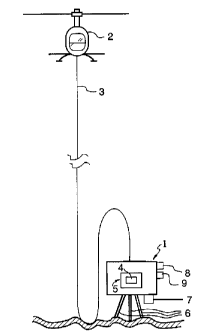
Turning to Figures 1, a gravimeter module 1 is shown suspended below a
2 5 helicopter 2 by a tow and communication cable 3 . The gravimeter module contains a
gravimeter sensor 4 and a self-levelling, dual-gimbal system 5. External to the
gravimeter module is a ground contact sensor 6, a ground proxi~ y sensor 7, a water
pressure monitor 8, and a water immersion sensor 9.
Figure 2 shows the component parts of the system gravimeter module 1 and its
3 o connection to equipment onboard the helicopter 2. The dual-gimbal system 5 is shown
comprising gravimeter system 4, level sensors 10 rigidly mounted to the gravimeter
CA 02213~ 1997-08-21
sensor 4 and a pair of servo motors l l . The level sensors lO, generate output signals
which are plOpOI lional to the offset angle of the gravimeter sensor 4, from vertical.
These signals control the servo motors l l, which, in turn, level the gravimeter sensor.
This system operates essçnti~lly as a closed feed-back loop.
Figure 5 shows, in somewhat greater detail, the operation of the self-levelling
system. The two level sensors lO are mounted and adjllcted so as to be orthogonal to
each other and to the mechanical (vertical) axis of the gravimeter sensor 4. Each level
sensor l 0 provides a DC signal output which, in sign and amplitude, gives an
indication of the deviation of its axis from horizontal, in direction and amount. These
signal outputs provide the measure of the deviation of the mechanical axis of the
gravimeter sensor 4 from the true plump-bob vertical. The dynamic range of theselevel sensors lO is typically + lS00 arc seconds, and their resolution is typically l arc
second.
The precision required in levelling is determined by the need to measure the
relative value of gravity to better than 5 ,uGals. In terms of effective precision of
alignment to the vertical, this means that the alignment error angle ~ must satisfy the
equation l-cos2~<5xlO~9 (i.e., ~3<20 arc seconds).
The gravimeter module l may come to rest at a substantial in~.lin~tion to the
horizontal, because of irregularities of the ground surface. The system of the present
2 0 invention is intended to allow for inclinations of up to 36~ from the horizontal. The
design of the self-levelling system is such as to accommodate such large inçlin~tions,
and yet perform the self-levelling to the required precision (<20 arc seconds) within
less than l 0 seconds.
In order to do so a two stage system is employed, including firstly a gravity-
2 5 based pendulum action and then a servo-motor-based action.
As Figure 5 shows, the centre of gravity C of the gravimeter sensor 4 is at a
distance L below the central point of suspension of the sensor. When the gravimeter
assembly l comes to rest on the surface, activating the ground contact sensor 6, the
signal from this sensor releases the clutches on the servo motors l l allowing the
3 o gravimeter sensor 4 to seek the vertical, as a pendulum.
CA 02213~ 1997-08-21
According to the theory of simple pçnr~ mc7 the period of oscillation of a
pendulum is given by
T = 2r~ , seconds
where L is in meters and g is the acceleration of gravity (lOm/s2). For
L = 0. lm, for example, T = 0.6 seconds. This means that regardless of the inclination
of the gravimeter sensor 4 from vertical at the landing site, once the clutches are
released, the gravimeter sensor 4 will pass through vertical in time T/4, or 0.15
seconds in this case. Thus, by re-eng~ging the clutches of the servo motors 11 at a
time T/4 after their final initial release? the gravimeter sensor will be quite close to its
required verticality. Thereupon the servo motors 11 are activated, each under the
control of its respective level sensor 10, to achieve the ultimate precision of levelling
(e.g. <20 arc seconds).
Alternatively, the clutches may be briefly reactivated several times on the initial
pendulum swing, e.g., at T/8 intervals, to reduce the maximum angular momentum of
the gravimeter sensor and therefore, the stresses on the clutches.
In this manner, even with several short activations ofthe clutches, the
gravimeter sensor 4 may be brought close to vertical, well within the range of the level
sensor 20 within one second. Thereafter, the clutches are engaged and, under thecontrol of the level sensor 10, the servo motors 1 1 may bring the gravimeter sensor 4
into vertical within the desired + 20 arc second range.
2 o The output signals from ground contact sensor 6, are provided to both the
gravimeter and to a control and data acquisition system 12, disposed in the helicopter,
via communication cable 3. The outputs of all other sensors in or on the gravimeter
module 1 are transmitted via the cable 3 to the control and data acquisition system 12,
in the helicopter 2.
2 5 A radar altimeter 13, located in the helicopter, provides quantitativeinformation on the height of the helicopter above ground. A high accuracy GPS
receiver 14, (preferably a dual-frequency, carrier-phase device) is mounted on the
CA 02213~ 1997-08-21
helicopter to provide rapid periodic updates of the spatial coordinates of the helicopter.
A display screen 15, provides all pertinent information to the pilot or operator. A
further reference GPS receiver 16, is preferably located in a fixed position near the
survey area to provide corrections for ionospheric changes on the moving GPS
receiver 14, either in real time by radio link, or off-line. More particularly, the di.ct~nce
measurement signals received from the s~tçllites (usually at least four or five s~tçllites
being monitored at one time) are affected by changes in the ionosphere which can lead
to erroneous h~ro--..alion. By subtracting the location information generated by the
secondary fixed GPS receiver 16 (within 50 km ofthe survey area) from the airborne
receiver 14, relative position coordinates are obtained and the effects of ionospheric
changes are cancelled. We have found that suitable GPS receivers for this purpose are,
for example, the Turbo Rogue receivers, manufactured by Allan Osborne Associates,
Tnc.
It is contemplated that the design of the gravimeter module I be based on the
well-proven Scintrex CG-3 AutogravTM, automated portable land gravimeter. This
system incorporates a quartz element sensor which is extremely rugged, and is able to
withstand shocks of up to 25 g without damage, and without offsets greater than 0.02
mGals. The system has no requirement for clamping between readings and is
compa~ible with helicopter vibrations in transport. The enclosure into which the2 0 gravimeter assembly is mounted is hermetically sealed, and is rated for immersion in
water up to more than 10 m deep.
In survey operations, the GPS receiver 14, m~int~in.c kin~m~tic lock with at
least four GPS satellites in flight, thereby providing the spatial coordinates of the
helicopter (latitude, longitude and altitude), commonly at one second update intervals,
2 5 at all times. Reliable coordinate generation requires that the receivers have an
essentially clear view of the sky at all times (ie. 2~1 field of view). Whereas, ideally, the
most approp.;ate position ofthe GPS receiver 14, would be directly on the gravimeter
module 1, in order to establish the exact coordinates of the gravimeter sensor 4, in
practice, this is rarely feasible due to tree shading and hills in most areas. In addition,
if the GPS receiver 14 is mounted directly on the gravimeter module 1, it is not
CA 022 1 3.7.7.7 1 997 - 08 - 2 1
possible to utilize the system in shallow water-covered areas, such as lakes, rivers,
swamps, and sea-coasts.
According to the present invention, the GPS receiver 14, is mounted on the
helicopter 2, or on the tow cable 3 at a very short dist~nce below the helicopter. Of
course, in order to ",~i"~ kinematic lock in this case, the helicopter 2 must have an
uninterrupted view of the sky at all times. This necessilates that the helicopter
m~int~in sufficient terrain clearance as to avoid all obstacles. In many areas, this
imposes the condition that the helicopter remain aloft while conducting the survey. For
survey operations, the cable 3 may be up to 30 m long for light helicopters like the
Hughes 500, or as much as 50 m for heavier helicopters such as the Aerostar AS-350
B-2, which is especially useful in water-covered areas.
The entire system according to the present invention is fully automated and
software controlled, such that the pilot is required only to respond to instructions on
the display screen 15. All decisions about data quality, for example, are made by the
software implemented by the system, as discussed in greater detail below with
reference to Figure 5.
At the start of a survey operation, the helicopter 2 and gravimeter module 1 areboth on the ground and are interconnected by the cable 3. First, the helicopter takes
off, rising vertically above the gravimeter module 1, and lifts it off of the ground. The
2 o helicopter then continues to rise to a transit level (eg. 100 m to 150 m) above the
ground and proceeds to its first designated gravity station, under GPS guidance.When, under GPS guidance, the helicopter 2, arrives at the location of a
predetermined gravimeter station, the pilot seeks out the nearest suitable site for the
station (eg. an opening in the trees) which is as free as possible of local topographic
2 5 irregularities. The pilot then reduces his elevation, slowly lowering the gravimeter
module 1 to the ground using the proxirnity sensor 7 as a guide to a soft landing. The
proximity sensor is designed to provide a quantative estimate of the di~t~nces of the
gravimeter module from the nearest ground point or water surface, with an accuracy of
about 10 cm, from 0 to lOm. A suitable such sensor is the 9000 Series, Piezo
3 o Tr~n.sd~lcer, m~nuf~cture by Polaroid Corporation. Lowering of the gravimeter module
1 to ground is followed, automatically, by the gravimeter measule-~,enl~ themselves.
CA 02213~ 1997-08-21
When all three legs of the tripod ground contact sensor 6 are on the ground, a signal is
generated thereby and is llanslllilled to the gravimeter module 1 to activate the self-
levelling process.
As discussed above, in order to obtain accurate gravimeter re- lings, the
relative elevation of the gravimeter must be c~lcul~ted in order to apply the usual
correction for elevation. This correction is given by the formula Ce = + (0.3086 -
0.0419 d) h, in mGals, where d is the density ofthe near-surface rocks, in g/cm3, and h
is the elevation of the gravity sensor in m., relative to a predetermined datum level (eg.
the elevation of GPS receiver 16).
For high precision regional gravity measure~"enls (eg. correct to 0.02 mGals) a
detell";nalion of h to within 10 cm relative accuracy is required. As indicated above, it
is feasible to achieve this relative accuracy of elevation by means of modern GPS
receivers. However, since the moving GPS receiver 14 is on the helicopter 2, and the
gravimeter module 1 is on the ground, a problem arises of determining the relative
elevation ofthe gravimeter and the GPS receiver on the helicopter, to within therequired accuracy.
Several solutions may exist, including the use of electro-optical ~ t~nce -
ranging devices such as microwave or laser-based systems, etc. However, these
devices are costly and complex in operation, and are difficult to automate.
2 0 The system of the present invention provides a solution to this problem. When
the pilot is over the selected station and is descen-iing the tow cable 3 bears the weight
of the gravimeter module 1, and functions, therefore, as a vertical "plumb-bob". In this
condition, the vertical distance between the gravimeter sensor 1 and the GPS receiver
14, on the helicopter, is predictably constant to within the required accuracy of 10 cm.,
2 5 provided that the tow cable 3 remains within 4~ of verticality. This distance l en.ains
constant, in fact, until the tension on the cable 3 is reduced by the gravimeter module
cont~cting the ground. This occurs at the precise moment when the last of the three
legs of the tripod on which the gravimeter module 1 is mounted touches firmly down.
This is also the moment at which the ground contact sensor 6 is activated. The ground
3 0 contact sensor 6 is so designed as to be activated only when all thrèe legs of the tripod
supporting the gravimeter module 1 have come to rest on the ground. The reason for
CA 02213~ 1997-08-21
this requirement is that when landing on an inclined surface the gravimeter sensor has
not assumed its true elevation until all three legs are on the ground.
To achieve this requirement, the ground contact sensor 6 is made to consist of
three individual contact sensors, one on each leg of the tripod. For simplicity, these
may be connected in series, so that the sensor will be activated only when all three
component sensors are so activated.
A suitable sensor component for this purpose, on each leg, may, for example,
be the AU-PB-SD-C push button switch m~n~lf~cture by Giannini Petro-Marine, Inc.which is both waterproof and sealed against mud, etc.
According to the present invention, a time marker is generated upon impact of
the gravimeter module l with the ground. This time marker is sent to the controltdata
acquisition system 12, where its time is recorded, relative to the GPS clock time base.
GPS receivers are commonly programmed to provide coordinate updates at
regular intervals, typically one second. The ground contact time markers will, of
course, generally occur somewhere between two successive GPS updates. In order to
determine the coordinates of the gravimeter l at the precise moment of landing it is
necessary to interpolate between successive GPS coordinates.
Since the vertical velocity of the helicopter 2 is not constant in the interval
sp~nning the landing of the gravimeter module l (eg. the pilot typically decelerates the
2 o helicopter in response to information from the proximity sensor 7), this interpolation is
not linear. It therefore requires the use of a higher order polynomial, (eg. 3rd order
polynomial), using two or more GPS coordinates before and after the contact timemarker, in order to determine the coefficients of the polynomial.
The ground contact time marker is also presented on the display screen 15, for
2 5 the information of the pilot. The pilot then descends a few metres, to provide enough
slack on the cable 3, to allow a portion of the cable to lie on the ground, thereby
decoupling any vibrations that might otherwise be transmitted down the cable 3 to the
gravimeter sensor 4. The pilot then hovers while the system completes the gravimeter
measurement (eg. typically 20-30 seconds duration).
3 0 Once the gravity measurement has been completed, with sflti~f~ctory accuracy
as determined by the software, a signal is sent to the control/data acquisition console
CA 02213~ 1997-08-21
l 2, and by it to the display screen l 5 to indicate completion of the survey data
acquisition. We have found that the DATA l data acquisition system, m~nuf~cturedby Scintrex T imited, is suitable for this purpose. The pilot then lifts off, carrying the
gravimeter module 1 to the next predetermined station. At the exact instant that the
tow cable 3 becomes taut (ie. when the first of the three tripod legs ceases cont~ctin~
the ground), the ground sensor 6 l,ar.s.,uls another timing signal. This time marker
provides a second measure, by interpolation, of the coordinates of the gravimeter
module 1 on the ground at the moment of li~c-off.
Figure 3 illustrates the method by which precise elevation of the gravimeter
station may be determined from a non-linear (eg. 3rd order polynomial) interpolation
between periodic (eg. l second) GPS coordinate updates, both on landing and take-off
of the gravimeter module l . The coefficients of the two polynomials, in this case, are
based on fitting the two GPS coordinate updates before and after the landing and take-
offtime markers.
The determination ofthe four coefficients of a polynomial ofthe 3rd order
which passes through four consecutive l second GPS elevation coordinate values may
be accomplished as follows:
The polynomial may be represented by the expression:
Z=A+Bt+Ct2+Dt3, where t is the time of the GPS measurement. For simplicity,
2 0 the value of t may be taken to be zero at the first coordinate measurement.It can be seen that A=Zo, i.e., the first GPS elevation (at time t=O). There arethen three equations in the three unknowns, B, C and D, for the elevations at the three
succee~in~ one second times:
Zl=Zo+B+C+D at t=l second
2 s Z2=Zo+2B+4C+8D at t=2 seconds
and Z3=Zo+3B+9C+27D att=3 seconds
These equations are readily inverted, to provide values of the coefficients, as
follows:
3 o B=[-l l Zo+l8Zl-9Z2+2Z3]/6
C=[2Z0-5ZI+4Z2-Z3]/2
and D=[-Zo+3Zl-3Z2+Z3]/6
CA 02213~ 1997-08-21
For the example shown in Figure 3, the polynomial representing the elevation
curve at the landing time maker is Hl--540-0.52t+0.063t2+0.002t3, while the
polynomial represçnting the elevation curve at the lift-offtime marker is
H2-53 8+0. 83(t-3 5)+0.086(t-3 5)2+0.0084(t-3 5)3.
Figure 4 shows the system of the present invention in operation at a station
which is covered with shallow water. The only physical change required to the system
for such use, is the addition of weights at the base of the gravimeter module 1, so that
it has sufficient negative buoyancy as to sink rapidly to the bottom of the water.
For this application, a water immersion sensor 9, provides time markers at the
moment of immersion and emergence, which permit the dete"~ina~ion of the GPS
elevation of the water surface. We have found that a suitable sensor for those purpose
is the LVl 1 Water Level Sensor, m~nllf~ctured by Omega, Inc. When the module
comes to rest on the bottom, the ground contact sensor 6 provides a time marker in the
usual manner, in order to allow the detel ~nination of the relative elevation of the
station. However, the water pressure monitor 8, provides an independent indication of
the water depth at the station which, when coupled with the elevation of the water
surface, gives still another measure of the relative elevation of the station. We have
found that a suitable water pressure monitor is the PX 216 - 030 AI model,
m~nllf~ctllred by Omega, Inc.
2 o Knowledge of the depth of water at the station is reguired in order to correct
for the negative gravity effect of the water Iying over the gravimeter sensor 4, at the
station. The approp,iate correction is given by Cw = + 0.0419 w, measured in mGals,
where w is the overlying water depth, in m.
When the station is water-covered as shown in Figure 4, the proximity sensor 7
2 5 serves to provide the pilot with distance information to the water surface, thereby
a~.cisting the pilot to ensure a soft landing on the water.
Other embodiments and modifications of the invention are possible without
departing from the sphere and scope defined by the claims appended hereto.