Note: Descriptions are shown in the official language in which they were submitted.
CA 02217319 1997-10-03
1
VOICE GUIDANCE TIMING IN A
VEHICLE NAVIGATION SYSTEM
BACKGROUND OF THE INVENTION
The present invention relates to the manner in which
a vehicle navigation system communicates a calculated route to
a driver. More specifically, the present invention relates to
the timing of warning prompts which alert the driver to
upcoming maneuvers.
Vehicle navigations systems employ a variety of
methods for communicating a route to a driver. One method
employs warning chimes to alert the driver to an upcoming
maneuver. Another employs a series of voice prompts. The
timing of these.chimes or voice prompts are crucial to
effective route guidance. If a prompt is delayed, the driver
may not be able to execute the maneuver in a safe and orderly
manner. If a prompt is issued too early and a significant
amount of time elapses before the vehicle arrives at the
maneuver location, the driver may not be properly alert.
Currently available vehicle navigation systems which
have warning chimes or voice guidance typically employ a fixed
distance at which the driver is warned of an upcoming
maneuver. That is, once the vehicle is determined to be
within a particular distance of the geographic location at
which the maneuver is.to be executed, the system issues the
warning chime or the voice guidance prompt. Unfortunately,
this method does not account for the often widely varying
characteristics of the environment in which the vehicle is
operating. For example, if the fixed warning distance is set
to provide adequate notice to the driver in a freeway
environment where the speed limit is 65 miles per hour, it
will likely be too long for a residential area where the speed
limit is typically 25 miles per hour.
Moreover, a fixed warning distance may cause
confusion by encompassing more than one junction at which
similar maneuvers may be executed. This will almost certainly
CA 02217319 1997-10-03
2
be the case where the fixed warning distance is set relative
to a freeway environment. Because such a warning distance
would be relatively long, it would likely encompass more than
one intersection in a different environment where the average
vehicle speed is considerably less such as, for example, a
residential environment. Such confusion is unacceptable if a
vehicle navigation system is to adequately guide the driver
along a calculated route.
It is therefore evident that a more flexible
approach is needed for communicating warnings of impending
maneuvers to the user of a vehicle navigation system.
' SUMMARY OF THE INVENTION
The present invention provides a vehicle navigation
system which communicates warnings of upcoming maneuvers in a
manner which takes into account the conditions under which the
vehicle is operating, thereby providing a flexible alternative
to previous systems. Once a route has been calculated, each
maneuver in the route is communicated to the driver at a
warning distance which may be varied according to a variety of
factors. According to one embodiment, the system calculates a
warning distance based in part on the current speed of the
vehicle. As a result, the warning distance more closely
resembles the actual distance required for the driver to react
to the maneuver instruction in a timely and safe manner.
According to another embodiment, the system
determines the link class of the road upon which the vehicle
is currently traveling and selects a warning distance
associated with the determined link class. Because the link
class of a road corresponds roughly to the speed at which one
travels on the road, this method has an effect on the warning
distance which is similar to that described above.
According to some embodiments, the present invention
adds another level of flexibility to deal with situations in
which road junctions having similar geometries are closely
spaced and are likely to cause confusion as to which junction
a particular warning prompt refers. Once the system
determines a warning distance for a particular upcoming
CA 02217319 1997-10-03
3
maneuver, it then determines whether there are any junctions
within the warning distance in advance of the maneuver
junction which present a similar geometry, i.e., any junction
which could be mistaken for the maneuver junction. If such a
junction is found, the warning distance is adjusted to be less
than or equal to the distance between the similar junction and
the maneuver junction. In a specific embodiment the warning
distance is set such that the warning is issued immediately
after the vehicle passes the similar junction, thereby
avoiding any confusion.
Thus, according to the invention, a method and
apparatus are provided for providing route guidance to a user
of a vehicle navigation system. A route is generated which
corresponds to a plurality of maneuvers. A warning distance
is determined from a particular geographic location associated
with a particular maneuver, the warning distance being based
in part on a variable parameter. A maneuver instruction
corresponding to the particular maneuver is then provided at
the warning distance from the particular geographic location.
According to one embodiment, the variable parameter
is vehicle speed. According to another, the variable
parameter is road segment link class. In some embodiments,
where the particular maneuver corresponds to a first junction
having a first characteristic, and a second junction having
the first characteristic is within the warning distance, the
warning distance is adjusted to an adjusted warning distance.
According to a more specific embodiment, the distance between
the first and second junctions. is defined as the first
distance and the adjusted warning distance is set to the first
distance where the first distance is greater than or equal to
the minimum limit. Where the first distance is less than the
minimum limit, the adjusted warning distance is set to the
minimum limit.
A further understanding of the nature and advantages
of the present invention may be realized by reference to the
remaining portions of the specification and the drawings.
. CA 02217319 1999-12-24
4
BRIEF DESCRIPTION OF THE DRAWINGS
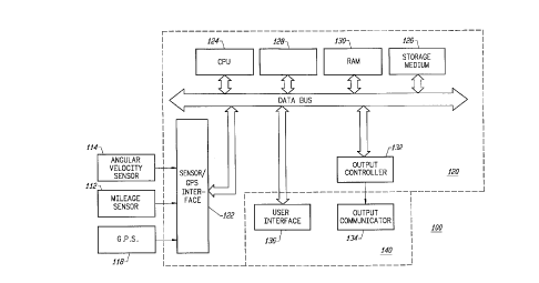
Fig. 1 is a block diagram of a vehicle navigation
system for use with the present invention;
Fig. 2 is a graph of warning distance vs. vehicle
speed according to a particular embodiment of the invention;
Fig. 3 illustrates a specific embodiment of the
invention;'
Fig. 4 illustrates another specific embodiment of
the invention;
Fig. 5 illustrates still another embodiment of the
invention; and
Fig. 6 is a flowchart which illustrates the
operation of a particular embodiment of the present invention.
DESCRIPTION OF THE PREFERRED EMBODIMENT
The present invention relates generally to commonly
assigned United States Patents No. 5,345,382 to Kao for
CALIBRATION METHOD FOR A RELATIVE HEADING SETfSOR, No.
5,359,529 to Snider for ROUTE GUIDANCE ON/OFF-ROUTE STATE
FILTER, No. 5,374,933 to Kao for POSITION CORRECTION METHOD
FOR VEHICLE NAVIGATION SYSTEM, and No. 5,515,283 to Desai et
al. for METHOD FOR IDENTIFYING HIGHWAY ACCESS RAMPS FOR ROUTE
CALCULATION IN A VEHICLE NAVIGATION SYSTEM.
Fig. 1 is a block diagram of a specific embodiment
of a vehicle navigation system 100 for use with the present
invention. Sensors 112 and 114 and GPS receiver 118 are
coupled to computing means 120 through sensor/GPS interface
122. In typical embodiments, mileage sensor 112 comprises an
odometer, and angular velocity sensor 114 comprised a
gyroscope, or a differential odometer coupled to the wheels of
the vehicle. A global positioning system (GPS) data receiver
118 is provided for receiving signals from, for example, a
satellite-based navigation system. Data from sensor/GPS
interface 12?~,is transmitted to CPU 124, which performs
calibration, signal processing, dead-reckoning, vehicle
positioning, and route guidance functions. A database
containing map information may be stored in database medium
CA 02217319 1997-10-03
126, with software directing the operation of computing means
120 stored in main memory 128 for execution by CPU 124.
Memory 128 may comprise read-only memory (ROM), or
reprogrammable non-volatile memory such as flash memory or
5 SRAM. System RAM 130 permits reading and writing of the
information necessary to execute such software programs.
Database medium 126 may comprise non-volatile memory, a hard
disk drive, CD-ROM, or an integrated circuit in which
digitized map information has been stored. Output controller
132, which may comprise a graphics controller, receives data
processed by CPU 124 and transmits the data to display console
140 which includes output communicator 134, usually comprising
a display screen with associated audio electronics and audio
speakers. The driver may input data, such as a desired
destination, through user interface 136, typically comprising
a keyboard.
The map database stored in database medium 126
preferably comprises positional data such as, for example,
latitude and longitude coordinates, to describe road
intersections or nodes, road segments, landmarks and points of
interest, and other geographical information. The data base
may further comprise data representing characteristics of
roads or places on the map, such as road and place names, road
features such as dividers, one-way restrictions, surface,
speed limit, shape, elevation, and other properties.
According to specific embodiments of the invention, the map
database includes cost values associated with individual nodes
and road segments. These cost values correspond to the
estimates of time intervals for traversing the respective node
or segment. Node cost values take into consideration such
information as, for example, whether the vehicle would
encounter oncoming traffic, thus delaying a left turn
maneuver. Segment costs reflect road segment characteristics
such as speed limit and segment length, both of which affect
the travel time along the segment. Also associated with each
road in the map database is a link class which relates to the
category or type of the road. For example, the highest level
category of the hierarchy is the link class FREEWAY. The
CA 02217319 1999-12-24
6
lowest level includes the link classes FRONTAGE and MISC which
include, for example, frontage roads and alleys.
The vehicle navigation system of the present
invention is operable to generate a route from a source
location to a destination according to a variety of different
methods. Some examples of such methods are described in the
U.S. patents which are listed above.
Once a route has been generated according to any of
to
a variety of methods, the system begins to communicate
maneuver instructions to the driver. Each maneuver
instruction is communicated at a variable warning distance in
advance of the location of the upcoming maneuver. The warning
distance may be determined according to different embodiments
of the invention. According to one method, the warning
distance for a particular maneuver instruction is set
according to the link class associated with the road on which
the vehicle is traveling as it approaches the corresponding
maneuver. For example, Table 1 shows warning distances for
different link classes according to a specific embodiment of
the invention.
Table 1. Warning distance table
Road Segment Link Class Warning distance (ft.)
Freeway 2112
Expressway 1214
Artery 1003
Street ~g2
Frontage 528
Ramp 1214
Connector 528
Miscellaneous 528
Access 528
40
CA 02217319 1997-10-03
7
According to another method, the warning distance
for a particular maneuver instruction is determined in part
with reference to the current speed of the vehicle. In a
specific embodiment, the warning distance is given by:
dw = dmax % Va > vmax ( 1.
dw = '''min + ~ ( d,~ax- ~in ) ' ( Va - Vmin ) J ~ ( Vmax- Vmin ) % Vmax ? Va
> Vmin
dw = d,nin % Va < Vmin
where
dw is the warning distance;
drain is the minimum limit;
dmax is the maximum limit;
va is the current vehicle speed;
Vmin is a minimum speed below which the warning
distance is the minimum limit; and
Vmax is a maximum speed above which the warning
distance is the maximum limit.
In various specific embodiments drain is 528 feet, d",ax is 2640
feet, Vmin is 25 miles per hour, and vmax is 70 miles per hour.
Using these numbers, equations (1)-(3) may be plotted as shown
in Fig. 2 with the horizontal axis representing vehicle speed
and.the vertical axis, representing warning distance. As
shown, below 25 mph the warning distance is constant at 0.1
miles (528 feet). Between 25 and 70 mph the warning distance
varies according to equation (2). Finally, above 70 mph the
warning distance is constant at 0.5 miles (2,640 feet).
Some embodiments also include a feature which sounds
a chime after the maneuver instruction has been given at the
' warning distance to alert the driver that she must execute the
maneuver almost immediately. The location at which the chime
sounds may be set at a fixed distance from the maneuver
location, e.g., 300 feet. Alternatively, the chime distance
may vary in a manner similar to the warning distance.
As mentioned above, even where the warning distance
to a maneuver junction has been determined with reference to
the environment in which the vehicle is operating, confusion
may yet arise because one or more junctions with similar
geometries lie within the warning distance. Such a situation
is illustrated by the diagram of Fig. 3. As the driver
CA 02217319 1997-10-03
8
proceeds along road 302 toward the next maneuver, i.e., a
right turn at location A, the system determines an original
warning distance 304 according to one of the embodiments of
the invention described above. If, however, the system
determines that another junction exists within warning
distance 304 at which the driver may also execute a right
turn, i.e., location B, the warning distance is adjusted to
the distance between location B and location A, i.e., distance
306. The system also sounds a chime at distance 308 where the
vehicle is nearly on top of the maneuver. According to a more
specific embodiment, if the adjusted warning distance would be
less than a minimum warning distance, the warning distance is
set to the minimum warning distance. In an even more specific
embodiment, each link class has a minimum warning distance
associated therewith.
Alternatively, where the system detects an
intermediate junction such as location B, the originally
determined warning distance is retained, but the substance of
the warning is changed. Thus, for example, if the warning was
originally to state "Turn right at next intersection", it is
changed to state "Turn right at second intersection".
Another warping feature is provided in some
embodiments to give the driver additional advance notice of an
upcoming maneuver. In freeway environments, drivers must
often traverse several lanes of traffic moving at high speeds
to exit. Because the distance required to execute such a
maneuver typically depends upon more than just the vehicle's
speed, an additional voice prompt is provided which allows the
driver to begin changing lanes well in advance of the desired
exit. Fig. 4 shows a pre-warning distance 402 from an exit
404 on a freeway 406 at which the driver is provided with a
voice prompt stating "Prepare to exit". Subsequently, at a
warning distance 408 from exit 404, the driver receives the
maneuver instruction "Next exit on the right". Pre-warning
distance 402 may be set in a variety of ways. According to
one embodiment it comprises some multiple of warning distance
408. According to another embodiment, each link class has a
fixed pre-warning distance associated therewith.
CA 02217319 1997-10-03
9
Fig. 5 shows a situation in which a pre-warning is
issued at a distance 502 from a desired exit 504 and a similar
exit 506 precedes exit 504. As with the example of Fig. 4, a
warning distance 508 is determined. However, because the
system detects the existence of exit 506, the warning distance
is adjusted to a new warning distance 510 at which location a
warning is issued stating "Next exit on the right".
Fig. 6 is a flowchart 600 which illustrates the
operation of a particular embodiment of the present invention.
Initially, a route between a source location and a destination
is generated according to any of a variety of methods (step
602). The route comprises a plurality of contiguous road
segments and a plurality of maneuvers to be executed by the
driver. The maneuvers are sequentially communicated to the
driver via a display console and audio speakers. Between
maneuvers, the system determines at what point to communicate
the next maneuver to the driver. To facilitate this
determination, the system either determines the current speed
of the vehicle and/or the link class of the road on which the
vehicle is currently traveling (step 604). The warning
distance is then determined (step 606) using the vehicle speed
or the link class depending upon which of the above-described
embodiments are employed.
The system then determines whether there is a
junction within the warning distance which is similar to the
maneuver junction (step 608). If such a junction exists, the
system determines the distance between the two junctions,
i.e., the first distance, (step 610), and whether the first
distance is less than a minimum limit (step 612). The minimum
limit may be a fixed value, or may vary according ~to the
current link class. If the first distance is greater than or
equal to the minimum limit, the warning distance is set to the
first distance (step 614). If, however, the first distance is
less than the minimum limit, the warning distance is set to
the minimum limit (step 616).
The system then determines the current position of
the vehicle (step 618). If no intermediate junction is found
in step 608, the system moves directly to step 618. The
CA 02217319 1997-10-03
system then determines whether the current vehicle position is
within the warning distance (step 620). If not, the system
continues to update the vehicle position until it is. If the
current vehicle position is within the warning distance, the
5 system issues a maneuver instruction voice prompt to the
driver (step 622). If the destination has been reached (step
624), the procedure ends. If not, the system repeats the
procedure with reference to the next maneuver.
While the invention has been particularly shown and
10 described with reference to specific embodiments thereof, it
will be understood by those skilled in the art that the
foregoing and other changes in the form and details may be
made therein without departing from the spirit or scope of the
invention. For example, the invention has been described
primarily with regard to the timing of voice guidance prompts.
However, it will be understood that the present invention may
easily be applied to the timing of warning chimes. The scope
of the invention should therefore be determined by reference
to the appended claims.