Note: Descriptions are shown in the official language in which they were submitted.
CA 02219649 1997-10-28
W O 96/35966 PCT~US96/06235
~ METHOD FOR DETERMINING VALIDITY OF SEISMIC REFLECTIONS
BELOW LATER~L VELOCITY VARIATIONS
The present invention pertains to det~rmining the
validity of seismic reflections and more particularly to
det~rmining the validity of seismic reflections that are
interface reflections occurring below lateral velocity
S variations.
In acquiring seismic data, a seismic source is used
to generate visco-elastic seismic acoustic waves that are
directed into the earth's surface. At changes in the
impedance of subsurface material, commonly called
interfaces, the waves are partially reflected back in the
direction of the seismic source at an angle governed by the
law of reflection. The reflected portions of the waves are
detected by seismic receivers. These receivers produce an
electrical signal representing the reflected wave which may
i5 then be dlgitized and recorded. Further processing uses
the recorded electrical signals to calculate the travel
time of the wave, approximate the average velocity of the
wave and determine the depth of the subsurface interface.
In general, it is assumed that the recorded electrical
signals represent (seismic) acoustic waves which have been
reflected once.
The data obtained is usually presented in the form of
time maps (e.g. seismic section, seismic trace, seismic
sample, and the like) which are arranged according to time
durations. The known factors are the source location, the
receiver location and the time duration from generation to
detection. The velocity of the seismic waves may be
approximated by any one of the many methods presently in
use. From these known quantities, the depth of the
reflector is approximated by time migration followed by
depth conversion. Depth conversion is the mapping of
CA 02219649 1997-10-28
W 096/35966 PCTrUS96/06235
seismic traces on a depth scale, that is, converting data
from time to depth. Time migration may be done either
before or after mid point or common depth point (CDP) data
is stacked or combined.
S Current seismic processing images p-wave reflection
energy. For salt wedges, the reflection from a subsalt
reflector is refracted, preventing the subsalt reflector
from being imaged by time processing. Often, data that
appears to be reflected data from beneath a salt overhang
is mapped giving the appearance of accurate data showing
various formations below the overhang. However, due to the
nature of the overhang, this data could not be reflection
data, at least not from the formations they inaccurately
depict.
Much prior art has produced methods that attempt to
image a subsurface formation below a significant lateral
velocity differential, such as that of an irregular salt
body. However, very little has been done to determine the
reliability of time processed data that ostensibly depicts
formations below the formations whose velocities vary
laterally.
In general, the most commonly used prior art methods
of time processing are incapable of determining the
location of interfaces through surface generation of
acoustic or seismic pulses when significant lateral
velocity variations are present. Prior art methods of
depth processing for accurately approximating these
interfaces require very detailed velocity information and
are not commonly used. In practice, most seismic data is
processed using time processing. However, methods for
determining the exact extent of reliable data from time
processed data are not prevalent.
CA 02219649 1997-10-28
W 096/35966 PCTrUS96/06235
The present invention discloses a method for
determ;ning the reliability of seismic reflection data near
a significant velocity differential overhang which includes
displaying the seismic reflection data as a seismic section
S showing impedance differential interfaces. The location of
an edge of the velocity differential overhang and acoustic
velocity values are used to determine a set of curves
representing boundaries of reliability for predetermined
dip angle values. The set of curves which represent
boundaries of reliability may be displayed. The display of
the set of curves representing boundaries of reliability
can be overlaid on seismic sections representing seismic
reflection data. The dip angle for a selected interface of
interest is approximated. The interface of interest is
1~ compared with the curve representing boundaries of
reliability for the dip angle for the interface of interest
to determine the extent of reliability of the data used to
map the end of the interface under the overhang.
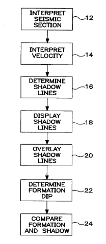
Figure 1 is a block diagram of the process for
determin;ng the reliability of seismic reflection data.
Figure 2 is an illustration of subsurface formations
showing the location of a salt layer, a dipping formation
and a reflection point.
Figure 3 is a seismic section illustrating subsurface
formations with a shadow line display overlaid.
The present invention discloses a method for
computing the smallest imageable dip at a specified
subsurface reflection point. For a given reflection point
(XR~ ZR) ~ there is a m;nimllm dip, C~in~ for which a normal
incidence ray reaches the surface without encountering the
salt body at (xS~ z5), (see Figure 2). If the reflector at
(XR~ ZR) has a dip less than ~in~ the ray will encounter the
CA 02219649 1997-10-28
W 096/35966 PCTrUS9''~ 5
salt body and be refracted in violation of the assumptions
behind conventional time processing. The actual dip value
can be computed from the reflector and salt coordinates and
from the velocity function V(z~) between the reflection
S point and the surface.
A method for computing the smallest imageable dip at
a specified subsurface reflection point. For a given
reflection point there is a mi nimllm dip for which a normal
incidence ray reaches the surface without encountering the
salt body. If the reflector at that point has a dip less
than the minimllm dip, the ray will encounter the salt body
and be refracted in violation of the assumptions behind
time processing. The actual dip value can be computed from
the reflector and salt coordinates and from the velocity
function between the reflection point and the surface.
Time processing of seismic data cannot correctly
image reflectors whose normal incidence rays pass through
an overlying strong lateral velocity variation. In this
situation, processing frequently produces spurious events
that cannot be valid reflections. This commonly occurs
when mapping reflectors under salt overhangs in the Gulf of
Mexico using time migrated data. Currently, interpreters
have no mechanism for checking the validity of events
during interpretation, resulting in processing artifacts
being mapped as reflecting horizons. The method described
here gives interpreters a quantitative guide for deciding
whether an event is a valid time processing reflection or
whether it is a processing artifact.
Referring now to Figure 1, the method of the present
invention is illustrated in block form. At block 12 data
is received and interpreted. The position of the edge of
the salt or other interfering formation is determined at
this point. Locating the position of the edge may be done
either visually or by setting mathematical criteria which
CA 02219649 1997-10-28
W 096/35966 PCTrUS96106235
,
the data must satisfy. This data is preferably in the
form of a seismic section although any form which can be
translated into a seismic section may be used. At block 14
other pertinent information is received, such as velocity
data.
At block 16 shadow lines are determined for each
depth for
predetermined dip angles. In the preferred embodiment
shadow lines have been determined for dip angles in
increments of ten degrees, from zero to sixty. In
practice, shallower angles or larger angles may be
eliminated or smaller or larger increments may be used,
depending on the formations of the seismic section being
viewed.
At block 18 the calculated shadow lines may be
displayed and at block 20, the shadow line display may be
overlaid on the seismic section. Again, in practice, the
shadow lines may be displayed directly on the seismic
section on a seismic interpretation workstation without
being transferred to an overlay display, combining steps 18
and 20. However, in the preferred embodiment, the shadow
lines are displayed on an overlay for simplicity.
At block 22 a formation along with its dip angle are
determined. This is the formation of interest that will be
analyzed to determine the farthest point under the overhang
which is based on reliable reflection information.
At block 24 the shadow line for a dip angle
corresponding to the dip angle of the formation of interest
is selected. The point where the formation of interest
intersects this shadow line is the point where the plot of
the formation on the seismic section becomes unreliable
(see Figure 3).
CA 02219649 1997-10-28
W 096~5966 PCTAUS96M6~5
Figure 2 shows how the method works. A basis for a
method for computing the smallest imageable dip at a
specified subsurface reflection point is illustrated. For
a given reflection point (XR~ ZR)~ there is a minim7lm dip
~in for which a normal incidence ray A reaches the surface
without encountering the salt body at (x5, z5)~ If the
reflector at (XR~ ZR) has a dip less than ~min~ the ray will
encounter the salt body and be refracted in violation of
the assumptions behind time processing. The actual dip
value can be computed from the reflector and salt
coordinates and from the velocity function V( ZR) between
the reflection point and the surface.
At any point below a salt overhang or other strong
lateral
velocity discontinuity, there is a m;nimllm time imageable
dip. If the reflector dip is less than this value, the
normal incidence ray will encounter the velocity ~nom~ly
and will be refracted at the non-horizontal interfaces such
that it will not satisfy the assumptions behind time
processing.
For a seismic line that is a dip line relative to the
reflectors of interest, we can compute the m; n im~m
imageable dip at each point in the subsurface, given the
location of the end of the overhang and the local velocity
function V(z). By finding all the subsurface points where
a particular re~lector dip will result in imageavle rays, a
set of shadow lines can be displated on the seismic data.
These lines indicate the maximum distance under the
overhang that a reflector with that dip should be mapped.
The shadow line for a reflector dip C~in is the set of
all subsurface reflection points (XR~ ZR) where a ray taking
CA 02219649 1997-10-28
W O 96135966 PCTAUS96/06235
,
off at angle ~n encounters the leading edge of the
velocity anomaly at (x5~zS)~ For any medium where velocity
V(z) varies only with depth, as assumed by time processing,
these reflection points can be found by using the ray
integral:
r ZR PV(Z)
XR ~ XS J dz
Zs ~ 1 -- p2V2 (z)
20 where:
sin Pmin
PV(ZR)
To define the shadow line for [lmin, a ZR that is deeper
than z5 must be chosen and, to obtain the corresponding XR~
the ray integral must be numerically evaluated. This
process is continued using successively deeper ZR values
until enough reflection points (XR~ZR) have been obtained to
define the shadow line down to the m~xi mllm depth of
interest.
For a general V(z) case, this computation involves ray
tracing through the layered velocity model. For the
special cases of velocity constant or linearly increasing
with depth, closed form expressions exist, although an
iterative solution is needed for the linear V(z) case.
The method requires that we be able to identify the
ray that originates at the reflection point of interest and
just touches the leading edge of the salt body at (xS,zS).
For constant velocity, the rays are straight and
t
XR -- XS = (ZR ZS) tan [lmin
This expression can be solved explicitly for any of
the three quantities XR~ ZR~ or [~min if the other two are
CA 02219649 1997-10-28
W 096135966 PCTrUS96/06235
specified. In the case of a linear dependence of velocity
on depth, a closed form expression exists for the ray.
Applying this to a ray from the reflection point to the
salt edge gives:
XS ~ X~, = COS ~~l~in ~ ~/I -- p2 (Vo + Kzs) 2
Kp
20 where
V(z) = V0+ Kz
and
sin C~in
ZR
This expression can be solved iteratively for any of
the three quantities XR~ ZR/ or [~in~ given the other two. A
general V(z) can be handled by iterative ray tracing, by
shooting a ray from the reflection point to the salt edge.
By finding all the subsurface points where a
particular reflector dip will result in imageable rays, we
can display a set of shadow lines on the seismic data that
show the m~x; ml7m distance under the overhang that a
reflector with that dip should be mapped. Figure 3 shows
an example of such a shadow line display on a seismic
section. A base line B is lined up with the leading edge
of a salt formation S. Shadow lines C, D, E, F and G
indicate, as a function of seismic time or depth, the
m~x; mllm distance behind the salt overhang that a reflector
with the specified dip, ten degrees, twenty degrees, forty
degrees, fifty degrees and sixty degrees, respectively,
would be imageable. When overlaid on a seismic section,
CA 02219649 1997-10-28
W O 96/35966 PCTrUS96/0
lines C, D, E, F and G constitute boundaries beyond which
no events of that dip should be interpreted.
For display on a migrated seismic section, the depth
coordinate has been converted to image ray (migrated) time
using a known V(z).
The restriction to dip lines is easily circumvented
for three dimensional seismic surveys by extracting a
series of arbitrary lines from the three ~imensional data
volume that are locally dip to the structure of interest
(but not necessarily dip to the velocity anomaly). By
constructing shadow lines (as in Figure 3) on each of the
arbitrary dip lines, we can define a set of shadow
"curtains" in three ~im~nsional space. As in the two
~imen~ional case, interpreters can use these shadow
surfaces to decide which events are valid reflections and
which events are processing artifacts.
While there has been illustrated and described a
particular embodiment of the present invention, it will be
appreciated that numerous changes and modifications will
occur to those skilled in the art, and it is intended in
the appended claims to cover all those changes and
modifications which fall within the true spirit and scope
of the present invention.