Note: Descriptions are shown in the official language in which they were submitted.
. ;
CA 02220274 1997-11-OS
WO 97/3936? PCT/US9?/00249
~~:chnicai Field
This invention relates to the general subject of seismic exploration and, in
particular, to apparatus and methods for. the exploration and production of
oil and
gas by identifying structural and stratigraphic features in three dimensions.
fn seismic exploration, seismic data is acquired along lines that consist of
geophone arrays onshore or hydrophone streamer traverses offshore. Geophones
and hydrophones act as sensors to receive energy that is transmitted into the
ground and reflected back to the surface from subsurface rock interfaces.
Energy
is usually provided onshore by Vibroseis vehicles which transmit pulses by
shaking the ground at pre-determined intervals and frequencies on the surface.
Offshore, airgun sources are usually used. Subtle changes in the energy
returned
Ito surface often reflect variations in the stratigraphic, structural and
fluid contents of
the reservoirs.
In performing three-dimensional {3-D) seismic exploration, the principle is
similar, however, lines and arrays are more closely spaced to provide more
detailed
sub-surface coverage. With this high density coverage, extremely large volumes
of
;digital data need to be recorded, stored and processed before final
interpre#ation
can be made. Processing requires extensive computer resources and coinpiex
,software to. enhance the signal received from the subsurface and to mute
accompanying noise which masks the signal.
Once the data is processed, geophysical staff compile and interpret the 3-D
seismic infom~ation in the form of a 3-D data cube (See FIG. 1 ) which
effectively
represents a display of subsurface features.. Using this data cube,
information can
be displayed in various forms. Horizontal time slice maps can be made at
selected
' depths (See FIG 2). Using a computer workstation an interpreter can also
slice
through the field to investigate reservoir issues at different seismic
horizons.
Vertical slices or sections can also be made in any direction using seismic or
well
CA 02220274 2004-03-22
WO 97139367 2 PCTlUS97100249
data. Time maps can be ironverted to depth to provide a structural
interpretation at
a specific level.
Seismic data has been traditionally acquired and processed for the purpose
of imaging seismic reflections. However, changes in stratigraphy are often
difficult
to detect on traditional seismic displays due to the limited amount of
information
that stratigraphic features present in a crass-section view. Although such
views
provide an opportunity to see a much larger portion of these features, it is
difficult to
identify fault surfaces within a 3-D volume where no fault reflections have
been
recorded.
Coherence and semblance (a measure of multichannel coherence) are two
measures of seismic trace similarity or dissimilarity. As two seismic traces
increase
in coherence, the mores they are alike. Assigning a coherence measure vn a
scale
from zero to one, °0" indicates the greatest lack of similarity, white
a value of "1"
indicates total or complete similarity (i.e., two identical traces). Coherence
for more
than lwo traces may be defined en a similar way.
One method for computing coherence was disclosed in U.S. Patent
No. 5,563,949 by Banhorich and Farmer. A method for compufiing semblance was
disclosed in U:S. Patent No. RE38,229 by Marturt et al. The Marfurt et al:
invention
included a brute force search over candidate dips and azimuths.
As goad as both methods have proved to be, they have some limitations.
Improved resolution and computational speed are always desirable.
In .accordance with the present invention, a multitrace eigen-decomposition
process is disclosed that is more robust and that has higher resolution than
previously known methods. In one embodiment of the invention, s method is
disclosed for the exploration of gas and oil. The method comprises the steps
of.
accessing a data set of seismic signal traces distributed over a pn~-
determined
these-dimensiortai volume of the earth: in a running window determining the
outer-
product of at least two data ~ vectors formed from at least two seismic
traces;
forming a covariance matrix by adding the outer-products; computing a seismic
CA 02220274 1997-11-OS
WO 97%,39367 3 PCT/US97/00249
_..
attribute that is a function of at least the dominant eigenvaiue of the
covariance
matrix; and forming a map from the computed seismic attributes over at least a
'part
of the pre-determined three dimensional volume of the earth.
In another embodiment of the invention, the process 'of the invention is
encoded on a computer readable media (e.g., magnetic disk, magnetic tape,
~ CD-ROM, etc.) for directing the operation of a computer to compute the
seismic
a'tfributes. In other embodiments of the invention, a map is prepared from the
above-
described process and the map is used to locate oil and gas deposits.
This technique is particularly well suited for interpreting fault planes
within a
3-D seismic volume and for detecting subtle stratigraphic features in 3-O.
This is
because seismic traces cut by a fault line generally have a different seismic
character than seismic traces on either side of the fault. Measuring seismic
trace
similarity, (i.e., coherence or 3-D continuity) along a time slice reveals
lineaments of
low coherence along these fault lines. Such coherency values can reveal
critical
subsurface details that are not readily apparent on traditional seismic
sections.
Also by calculating coherence along a series of time slices, these fault
lineaments
identify fault planes or surfaces.
' Numerous other advantages and features of the present invention will
become readily apparent from the following detailed description of the
invention, the
embodiments described therein, from the claims, and from the accompanying
drawings.
FIG: 1 is a pictorial representation of the information obtained from
processing 3-D seismic data;
FIG. 2 is a pictorial representation of a horizontal time slice of 3-D seismic
data processed in accordance with the prior art,
FIG. 3 is a drawing depicting two adjacent seismic traces;
FIG's. 4 through 8 are schematic diagrams depicting the coherency of a
pair of seismic traces in accordance with the present invention;
FIG. 9 is a pictorial representation of a running window analysis cube;
FIG's. 10A, 10B and 10C are schematic diagrams of groups of seismic
traces;
CA 02220274 1997-11-OS
WO 97/39367 4 PCT/L1S97/00249
FIG's. 11A, 11B and 11C are schematic diagrams of two dimensional
analysis windows;
F1G. 12 is an elementary process flow diagram; and
F1G's. 13A, 138 and 13C are pictorial representations of the same
- 5 horizontal time slice in accordance with the inventions of Bahorich et
al., Marturt et
al. anii the present invention.
Detailed Description
White this invention is susceptible of embodiment in many different forms,
there is shown in the drawings, and will herein be described in detail,
several
speci-fic embodiments of the invention. It should be understood, however, that
the
present d-isciosure is to be considered an exemplification of the principles
of the
invention and is not intended to limit the invention to the specific
embodiments or
algorithm so described.
Before describing the process of the invention, the underlying principle of
operation will be described.
Consider two traces t, and tj over a specified time window or depth
window of N samples for which coherence is to be evaluated. A representative
diagram of the traces and the relevant analysis window is shown in FIG. 3. The
first trace t, consists of the time series (t~~, t~z, ..., t~N) and the second
trace ti
consists of the time series (t2~, tzz, . ., tzN). In these two time series,
the first index
refers to the trace number (i.e., trace 1 or trace 2), while the second index
refers to
the sample number.
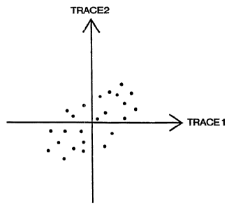
By plotting one trace against the other in the familiar two-dimensional
Cartesian coordinate system a better understanding of the meaning of coherence
in
the context of the present invention can be obtained. Plotting equivalent time
samples from the two traces (i.e., the point pairs (t", ti,), (t,z, tzz), ...,
(t,N, tzN)l~
produces a crossp(ot of the two time series. Letting the-x-axis represent the
fiirst
tracertH and the y-axis the second trace tr, vaults in the diagram~depicted in
FiG.
4. It is the pattern formed by these points which manifests the coherence of
the fwo
traces.
The general shape of these two correlated traces is a set of points
represented by an ellipse. This ellipse is a generalization since it does not
2
CA 02220274 1997-11-OS
WO 97!39367 5 PCT/CTS97l00249
represent each individual point but rather describes the "overall" nature of
al! the
points. The major and minor axes of this ellipse will be oriented in a
direction which
is determined by the geometry of the paired points. The lengths of the two
axes are
also determined by this geometry. A typical representation of these points and
the
corresponding ellipse is shown in FIG. 5.
The directions and magnitudes of the major and minor axes of the ellipse
may be represented by two scaled vectors with the longer vector oriented along
the
major axis and the shorter vector along the minor axis. The magnitudes of
these
two vectors correspond to the two eigenvalues of the data covariance matrix
and
the normalized vectors correspond to the eigenvectors. The eigenvectors,
scaled
by their respective eigenvalues, denote the magnitudes and directions of the
major
and minor axes. The "principal component" corresponds to eigenvector which is
associated with the dominant eigenvalue.
The figures that follow (FIG'S. 6 through 8) are intended to give an intuitive
understanding of the mechanics behind the previous discussion. In these
figures,
traces are constructed using simple amplitude and phase variations, and the
effect
o~ these variations is observed on the associated eigenvaiues and
eigenvectors.
FiG. 8 demonstrates how iwo identical traces degenerate to a 45 degree
line, (i.e., an ellipse with the minor axis collapsed to zero). The "zero
length"
indicates that the second eigenvalue is "zero" and indicates that the
eigenvector
corresponding to the dominant eigenvalue is aligned with the major axis. The
coherence is maximum, with a value of one.
The situation for iwo traces having equal amplitudes and a 45 degree
phase difference is shown in FIG. 7. This demonstrates how a phase shift
lengthens the minor axis and therefore increases the magnitude of the second
eigenvaiue. The two eigenvectors scaled by their respective eigenvalues are
also
shown. Dus to the difference in these traces, the coherence is reduced to a
value
i
of less than one.
Finally, in FIG. 8 both the phase and amplitude are allowed to vary. The
two traces have both a 45 degree phase shift and a 2 tot amplitude ratio. The
resulting ellipse has a nonzero minor axis (the second eigenvalue is nonzero),
reflecting the phase difference. In addition, the ellipse and eigenvectors are
rotated
due to the amplitude difference. Again, the amplitude and phase variations
produce
- a reduction in coherence.
CA 02220274 1997-11-OS
WO 97/39367 6 PCTIUS97/00249
The main point of the forgoing discussion is to show heuristically that
coherence can be expressed as a function of the eigenvalues, ~.~ and ~.z, and
the
eigenvectors v, and vz. Functionally, an expression for coherence is:
Coherence = ,~ (~,, ~.z, v,, vz). (1 )
This procedure for two traces can easily be extended to any desired '
number~of traces. From a practical standpoint, the computational burden
increases
with an increasing number of traces and limitations are imposed only by the
available computing power. For a 3-D seismic data set, this analysis can be
repeated over a moving or running analysis window in space and time (or space
and depth), resulting in a measure of coherence at the center of the moving
window. The output is a 3-D data set consisting of coherence values defined
over
the original data volume.
It wilt become apparent from the following discussion that one advantage of
this process is that different aspects of the data are distributed among the
eigenvalues and the eigenvectors. Information, such as amplitude and phase,
can
now be analyzed and dealt with in a robust and rigorous way. Resolution, for
example, can be improved by manipulating the eigenvalues and eigenvectors. The
benefits can be observed visually in the computed coherence slices. Another
important aspect of coherence values in accordance with the present invention
is
that they exhibit sensitivity to discontinuities in the original data and
reveal subtle
geological features, such as faults and channels.
Returning to the process of the present invention, the first step is to obtain
or access a set of three dimensional seismic data. Such data is in the form of
seismic signal traces distributed over a three dimensional volume of the
earth.
Methods by-which such data is obtained and reduced to digital form for
processing
as 3-D seismic data are well known to those skilled in the art. Such data is
routinely acquired by geophysical vendors who specialize in land surveys or
ocean
surveys. Such data is also sold or licensed by vendors and is generally
conveyed
or stored on magnetic tape for transfer into the memory of a seismic work
station.
The next step is to divide the 3-D data set into a pturality of cells or
analysis
cubes 20 (See FIG. 9). These cubes 20 perform the function of dividing or
sorting '
the seismic data into groups or cells for further processing. in effect, one
analysis
cube sweeps through the entire seismic data set or 3D data cube 30. Each
analysis cube 20 comprises a stack of generally flat rectangular time layers
22.
CA 02220274 1997-11-OS
WO 97!39367 PCTlLTS97100249
7
For the purpose c3f simplicity, the 3-D data cube 30, the analysis cube 20,
and the time layers 22 are shown in the form of right-angled parallelepipeds
or
cubes (generically a "cell"). Thosa skilled in the art will appreciate the
simplicity of
(rectangular geometry in performing repetitive operations over 3-D data set.
Other
geometry and cell shapes are possible and may be warranted under the
'circumstances.
Returning to F1G. 10, each time layer 22 or stab has portions of seismic
traces t1 (only one being shown to avoid cluttering the drawings) passing
therethrough. Nine traces, laid out in a 3 by 3 evenly spaced grid are
depicted in
FIG. 9. Five traces in a star pattern (See FIG. 10A) or three traces (See FIG.
10B)
may be used. A symmetric arrangement is preferred. Nine traces in each time
i layer are often better than three traces. Two traces are the least that can
be used.
To help visualize the concept of the invention, the reader is refered to
~ FIG.'s 11A and 11 B. In particular, it is often difftcult to visualize these
concepts in
nine dimensions {as is the case of 9 traces). In FIG.'s 11A and 118, a two
I, dimensional running window 24 (or analysis window) is shown with just two
traces
~, t, and tl contained therein. Each trace (See F1G. ? 1C) comprises a time
series of
~, N samples
t) _ (t11, t12~ ..., t1N)
2~ ~' {t21~ ~22, ..., t2N)
The analysis window 24 of FiG. 11 C is further divided into a plurality of
vertically
stacked, rectangular time layers 22.
Before proceeding, it should be understood chat, in choosing window size
and spacing, there is a tradeoff between resolution and stability. In other
words,
~~ smaN analysis windows or cubes allow higher spatial or temporal .frequency
in the
~, resulting parameter estimate, but give less statistical stability or fewer
degrees of
freedom to those estimates. On the other hand, very large windows have poor
resolution and tend to smear the data such that important geologic features
may be
lost.
Returning to F1G. 11C, the data points within each time layer 22 define
seismic data vectors (here a 1 by 2 matrix, where N=2). As such, the two
dimensional time layers of FIG. 11C (or the three dimensional time layer of
FIG. 8)
CA 02220274 1997-11-OS
WO 97/39367 8 PCT/US97/00249
form or define vector windows. Thus, nine traces (N=9) will result in a data
vector
having nine elements.
The outer product of the data vector within each vector window or time
layer 22 results in a N by N matrix. So a nine element data vector gives rise
to a 9 ;
by 9 matrix. Adding these matricies (one matrix for each vector window)
results in
a N by N covariance matrix for the entire analysis window 24 (or the analysis
cube ,
20). So if the analysis cube comprises nine time layers, nine N by N matricies
are
added together to form one N by N covariance matrix.
In accordance with the present invention, a very useful and non-obvious
measure of trace coherency is obtained by computing the eigenvalues of the
covariance matrix. tn particular, the largest or dominant eigenvalue of the
covartence matrix and the sum of the eigenvalues of the covariance matrix are
computed. The ratio of these two numbers represents the size of the dominant
eigenvalue relative to the sum of eigenvatues. It also indicates the
variability of
traces within the analysis cube. Expressed mathematically, a useful seismic
attribute is represented by:
~' _ '~'
N
a'i
i-1
where a., are the eigenvatues of the covariance matrix, and ~., is the
dominant
eigenvatue. As such, ~ is an indication of how well the point elements of the
seismic data vectors are correlated (See FIGs. 4 and 5).
Each and every eigenvalue of the respective covariance matrix need not be
expressly calculated. Those skilled in the art know that methods exist for
calculating just the dominant eigenvatue (e.g., the power method, the Rayleigh
quotient, jthe faster of the twoj, etc.). Moreover, it is also known that the
sum of the
diagonal elements of the covariance matrix is equal to the sum of the
eigenvalues
of that covariance matrix. For convenience, the ratio (i.e., a measure of
coherency)
of equation (2) can be assigned to the center of the analysis cube 20 or the
analysis window 22. It should be appreciated that one advantages of using the
dominant eigenvalue is that it tends to more directly show the variability of
the
traces within the analysis window. The dominant eigenvector would not be a
measure of the variability (i.e., the coherence).
CA 02220274 1997-11-OS
WO 97/39367 9 PCT/US97/00249
In performing this measure of coherency, the analysis cube 20 or analysis
window 22 effectively sweeps (i.e., laterally and ver#icaily) accross the
entire 3-D
volume of FlG. 9 or all the traces of FlG. 11A. Preferably, adjacent analysis
cubes
20 or vector windows 22 overlap one another (See windows 24, 24' and 24" of
FIG.
1',1A). Overlap improves spatial resolution.
The result of the analysis cube 20 sweeping over the entire 3D data volume
3Q artd the assignment of the coherency measure of equation (2) is an array of
coherency values assigned along each trace at the location of each data
vector.
As such, the 3D data volume is conwerted into a 3D "coherency cube."
The data or coherency measures contained within the coherency cube is
most conveniently interpreted by displaying the coherency data in the form of
a
seismic attribute map. Such a map is most often in the form of a display of
those
coherency values lying along a surface passing through the coherency cube. Two
examples are a flat plane passing through a common horizontal time slice, and
a
curved surface passing through a seismic horizon line selected by a seismic
interpreter. Another example is a line representative of geologic depositional
time
so as to capture features from the same geologic age.
The coherency values are easily displayed for interpretation when
displayed as a shade of gray {e.g., white indicating the highest coherency and
black
indicating the lowest coherency) or another color scale. (See US Patent
4,970,699
for a "Method for Color Mapping Geophysical Data").
Landmark and GeoQuest interpretive workstations, for example, can be
used to view and interpret faults and stratigraphic features by loading the
coherency cube as a seismic volume. Such workstations are commonly used by
those skilled in the art. Unprocessed 3D seismic data can be conveniently
Loaded
onto the workstation by means of a magnetic tape or disk which is encoded with
instructions for the computer to perform the above-described process.
Visualization software (e.g., Landmarks's SeisCube software) may be employed
to
rapidly slice through the coherency cube to aid in understanding complex fault
relationships. Coherency displays, including printouts in the form of seismic
attribute maps, can reduce interpretation cycle time when used in.selecting
which
seismic lines to interpret, enabling the interpreter to work around poor data
areas.
In addition, subtle stratigraphic features and camplex faulting, which are not
readily
apparent on traditional seismic displays, can be rapidly identified and
interpreted.
CA 02220274 1997-11-OS
WO 97/39367 ,~ ~ PCT/US97/00249 -
FIG's. 13A, 138 end 13C provide comparisons _ of the same seismic
information displayed and processed by other processes and in accordance with
the present invention. The differences are readily apparent.
Of course, the process of the invention is most conveniently carried out by
writing a computer program to carry out the steps just described. Such
processes
are routinely carried out on work stations previously identified.
An elementary process flow diagram is illustrated in FIG. 12. In one
embodiment of the invention, a software program is written in FORTRAN 77 to
perform the process just described. 3-D seismic data 30 is read into memory.
Based on the size and content of the available seismic data, an initialization
step 32
is performed, program parameters are initialized, data ranges are estabtished,
preliminary checks are made, and window sizes are set. Defaults are read or
user
selected options are read. Next processing 34 is begun. In particular,
subroutines
36. are called to sweep the data volume with an analysis cube. Within each
analysis cube, a subroutine 38 computes the covariance matrix, and another
subroutine 40 computes the dominant eigenvalues, the sum of the eigenvalues
and
the resultant coherency value. Finally, the results are combined 42 and the
computed values are stored 44 in the form of a coherency cube. Thereafter, a
workstation operator can access the coherency cube to display selected
portions
te.g., time slice through the cube) on a CRT 46, to create a printout or
seismic
attribute map 48, to perfomz further analysis or to transfer to memory or to a
tape
50 for further processing elsewhere.
Those skilled in the art are cautioned to use the method of the invention
with due regard to what is known about the stratigraphy and geology of the
region
covered by the 3-D survey.
Coherency maps have been run on several 3-D surveys. At depths of
reasonable data quality, approximately 90% of the faults can be readily
identified.
Faults were identified on coherency maps which wens very subtle on seismic
sections, but clearly present on the coherency maps because of the robustness
of
the method and the map perspective of fault patterns. Since coherency maps can
be run on uninterpreted time slices, the present invention offers a means to
greatly
accelerate mapping of the structural framework and to reveal details of fault
relationships which would otherwise be interpreted only through tedious fault
picking.
CA 02220274 1997-11-OS
WO 97%39367 ' ,~ PCT/US97/00249 -
- _.
~~ecific Examples -
Coherence maps were generated along picked horizons
and clearly identified saltlshaie diapirs offshore
In other locations mud and gas volcanos were clearly
indicated using the process of the invention.
Several coherence time slices showed remarkable details
of stratigraphic features, such as abandoned river channels, mud
flows, point bars and submarine canyons. On seismic sections,
these features were sometimes apparent but, in some cases, were
unidentifiable even with close scrutiny.
I This invention, like that of Bahorich et al. and Marfurt et al., provides a
method of revealing fault planes within a 3-D volume where no fault
reflections have
been recorded. Faults are often critical to the accumulation of oil. A fault
may form
a seat by cutting off a structural or stratigraphic feature so the oil is
trapped against
the fault. On the other hand, if the fault plane contains rubble that has not
been
cemented, it may form a conduit for fluids. This may allow the hydrocarbons to
drift
up the fault plane into the feature and be trapped in it or to escape from the
feature
by drifting up the fault plane out of it. Thus, fault lines can predict flow
patterns in a
reservoir and communication between injector and producing wells, for example.
I Seismic discontinuities can also provide the needed link to enable reservoir
prediction between the wells and establish reservoir continuity and flow
patterns
across a field. Coherency technology can be used for finding, identifying and
mapping of subsurface structural and sedimentological features such as faults,
salt
diapirs, unconformities, channel systems, karsting and carbonate reef facies
which
are commonly associated with' the entrapment and storage of hydrocarbons.
Therefore, this technology aids in the finding, extraction and production of
hydrocarbons. In addition, it is used for identifying both shallow and deep
drilling
hazards (e.g., places where there is gas that is too close to the surface or
where
there are instabilities). Still another example is the use of the invention to
search
for leakage paths from known reservoirs or underground storage caverns.
' Coherency mapping of 3-17 seismic is an extremely powerful and efficient
tool for mapping both structure and stratigraphy. The new method is
particularly
sensitive to any lateral variation in wavelet character and therefore is
particularly
sensitive to the common causes of lateral variations in the wavelet (i.e.,
fault
CA 02220274 1997-11-OS
WO 97/39367 PCT/US97/00249
a2
displacement or stratigraphic variations). Thus, the subject invention
encompasses
a process, devices on which the process is recorded in the form of computer
instructions, the product (e.g., a map) of that process, and the manner in
which
such a product is used in the exploration of gas and oil.
From the foregoing description, it will be observed that numerous
variations, alternatives and modifications will be apparent to those skilled
in the art.
Accordingly, this description is to be construed as illustrative only and is
for the
purpose of teaching those skilled in the art the manner of carrying out the
invention.
For example, the seismic traces have been depicted as having equal spacing.
Unevenly spaced traces (See FIG. 10C) may be conveniently converted into even
spacing by interpretation. As another example, it may be useful to filter the
traces
forming the data vector to eliminate outlyers. A median filter may be used to
sort
the elements of each data vector. Edge cutoffs may be used to achieve further
smoothing.
Moreover, other algorithms may be used to measure the similarity of
nearby regions of seismic data or to generate the "coherence cube." The
coherency value or seismic attribute of equation (2) serves as a rather robust
estimate or measure of signal discontinuity within geologic formations as well
as
signal discontinuities across faults and erosionai unconformities. Other
combinations of the eigenvalues of the covariance matrix are suggested (e.g.,
arithmetic mean, root mean square, average, median, square root of the sum of
the
squares, square root of the product of the squares, minimum, maximum, sum,
product, etc.). Moreover, the process of the invention may be combined with
other
attributes (e.g., AVO slope, etc.) and also applied to multi-component seismic
data.
Also certain features of the invention may be used independently of other
features of the invention. For example, geologic features identified in
accordance
with the present invention can be overiayed with a velocity map to provide a
means
of cross checking the velocities.
1n addition, white coherence slice maps by themselves are very powerful
mapping toots, when used in conjunction with reconnaissance mapping of
amplitudes and dip maps, there is promise of a technological milestone in
mapping
effectiveness for the Gulf of Mexico or similar basins with 3-D seismic data
readily
available. it is believed that detailed mapping of structure and stratigraphy
yvill be
accelerated by mapping in a map view and less by traditional line by line
picking. .
Interpretation in a map view of '°reconnaissance" data offers
significant
CA 02220274 1997-11-OS
WO 97/39367 PCT/US97/00249 -
13
improvement in quality aRd quantity of interpretation. Moreover, the process
of the
invention is inherently fast. Such speed aids in rapidly making bidding
choices
when concessions become available.
Finally, it should also be understood that the principle of the invention
should be equally applicable to other fields (e.g., passive sonar, in which
case the
sensors would be acoustic and l:he signal sources could be hostile submarines;
~ earthquake and nuclear weapon detonation detection systems, in which case
the
sensors would be seismic and the signal sources could be earthquake or
explosion
epicenters; astranomicai interferometry, wherein the sensors would be
radiotelescopes and the signal sources could be distant galaxies or quasars;
and
phased-array radars in which case the sensors would be the array antennae)
wherein signals (e.g., radar, sonar, radio frequency energy, etc.) are
processed to
form images or locate changes in the structure represented by such images.
i
Thus, it will be appreciated that various modifications, alternatives,
~ variations, and changes may be made without departing from the spirit and
scope
of the invention as defined in the appended claims. It is, of course, intended
to
cover by the appended claims all such modifications involved within the scope
of
the claims.