Note: Descriptions are shown in the official language in which they were submitted.
CA 02222300 1997-11-26
P16083.S01
NAVIGArrXON AP~ARATUS
BA~Cl~ OUNl~ OF ~. lM~F~TION
1. FieldoftheInvention
The present invention rel~tes to a nav~gation ~ppalPlus which displays ~e
cur~ent loca~on of th~ ~pp~h~s using a positio~ ~lete~ n system, such as ~he global
positiIlg s~ e (GPS) network. ~ore par~cularly, ~e present ~nvention relates to
a ~aviga~don ap~ ls which can displ~y the ~ t loca~ion of ~e ~p~r&lu~ orl a
displayed image of a m~p.
2. R~k~rolL~d~ndM~t~lIn~orn~tion
0 Prior art naYigation devices stors each p~s~on on a map as mlmorieql
coordinates ~n a pre loaded s~ge n)~i~lln su~ch a CD-ROl~ or ~ d. When ~e
device ~CU~ ,5 ~oord;~l~ fo~ its cu~rent posi~on based on the G~S sigllal, a
appro~riate map is retrieved ~om the storage medium, wh~n ~e map~ and ~e
c.ullci~ position on ~he map, a:re displayed o~ a screen.
A d~ai~&ck of ~e ~bo~ ior a~ igation ~eviGe is ~e na~re of ~e storage
...~Ji~ ile Cr)~OMs can store a cQ~ d~bl~ amoullt of ma~ e~ use in
po~table ~ts is llm;t~A by lhe rela~vely l~e size and hi~ powe~ c~.Y~"~tion of
~e CI) reade~. IC card based ~its are Cnl~ r and use less elec~ici~, bu~ nly
store much smaller maps due to limited stor~ge capac~ty.
~0 A fiJrdler drawback ofthe above n~rigation de~ices is that ~e regio~al maps
stored ~n ~e CD or IC cald may not ha~re s~ nt detail c~-y ~rCd wi~ local p~ed
maps. This can pro~e especially difficult i~ a us~r reduces ~e display scale or is
looking for a local l~ nark.
Another t~pe of prior a~ navigation a~para~s works in co~bin~t;on with a
2!~i prin~ed map. Thi~ device obtains ~e GPS coordinates of 1 he curr~t positio4 ~nd
CA 02222300 1997-11-26
P16083.~01
display ~he same along with ref~e~ and Inn~ldin~l lines on a ~spa,~nt
display. A ~ physic~lly holds ~e tl~&~ t d~spla~ over the rrinte~ n~ap to
det~e t~e current position on ~e map.
Since ~e above navigation dev~ce relies upon a prirlted map prov~ded by ~e
5 user~ a lo~a~ map u~h super~orTe~ional detail c~n be used as ~,..y~ret wit~h the maps
stored and sold ul a CD or rc gta~ge n~ rn However, si~ce the kal~spa~ t
display mu~t be ph~i~ally ~ o~ed ovel~ ~e printed map, ~e use~ must
cont;ml~lly ~pread out ~ ma~ and align ~e l~nn~ ~t displ~ to dehl~le C~f~lt
location. This proces~ bersome, e~peci~ly when ~at an~or d~ s~ ee-c ale
0 u~a~ailable to la~ ~e ~ted map on.
SUM~ OF THP ~V~T~ON
It is a~ordingly an object of ~e p~c~5c~ vention ~o overcome ~he a~ove
drawbacks of t~e p~ior a~t.
It is ~no~ o'cject of ~e inven'don to p~ride a naviga~ion a~a~ s which
5 c~ scan or i~put ~ sp ~i~e mAp into memory, and th~ ~ispl~y ~at m~ and the
cu~ent position of the device.
Accordingto an embodimerlt of ~e ~n~ ion1 t~ere is provided a na~rigati~
apparatus in~ dil~g meas~g device which measu~es ~e la~tude ~d longitude of
~ cU~reotpocition An ima~e ~t de~ce ~ iv~ ~nap da~ associated wi~ ~ map.
2 o A di~p1ay device display~ the m~p dlat~ as a m~p ima~e. A dat~ ~nput device ~bles
en~y of map inforrn~tion, An ~s~i~meJlt device ~ t;hl~e and lon~itude
coor~ tes to ~t least one pOil~t on ~e m~p b~sed on at least one of the map
i~fu..~ io~ ~d a Ie~erenoe on he ma~ to es~blish a cuordinate system. A co~ol
device ~u~ poses the c~rent positior~ o~ the map ~ e o~ the displ~y de~ice
based o~ ~e coo~dina~ ~ystem.
CA 02222300 1997-11-26
P16083.S01
Accordi~lg to a fieature of the above embo~l;ment, ~e data input device inclu~l~ s
a conlrol panel, ant the ma~ n Lncludes coord~l~tes of at least one refe~ence
pogi~on o~ ~e map image input ~ia ~e control panel
According to ~n~ r featule ofthe above ~nborlim~nt, i~e data input device
includes ~e tn~ dev~ce, and ~ t ;on includes coaTdinates ~or ~e
loca~on, received by the n.~.~,.ri~,g de~rice, when ~e c~ loc~tio~ is a
cc position on the ma~ ge.
AcGonlillg to yet aIlotheI~ fe~ e of ~e ab~ve embodim~.nt, ~e map
hlf~ tion includes a scale o~t~e map.
0 Accordi~ yet a~o~er fea~e of the above embo~lim~t~ ~e raap
infn~n~tion incltl~S co~d~ ds of a~ least tvvo ~f~ e points, inp~t by a user~ onthe map.
Accordin~ to s~ll yet ano~er fean~re of ~e above emboriim~nt~ ~e map
in~orma~ion incl~des ~he cuIrent location when ~he dev~ce is at a fi~st reference
positioII on ~e map imag~, and t~e cur~e~t lo~a~on when the devi~ is at a second
r~e.~uc6 position on l~e rnap image,
Accordirlg to ano~er fea~e of ~e above embo~limeJ~t~ a de~i~e r~cog1~i7~s
rer~ ,ce l~s on a ~ .~d map. The ~ i~m~n~ device assigns ~ de ~nd
IQ~h~ coo~d~n~tes to poLnts on ~e map image ba~0d Ol~ the refe~ence l~nes.
Accord~Il~2 to yet Pnoth~ ~eature o~the abo~e embo~imeI t ~e image input
devi~e inrJ.llJde~ a ma~ reading s~c~ion, and a sectio~ ~at only ~eads ~e ref~e~ce lines
fiom ~e ptinted map.
Accord~g to yet another f~ature of ~e above embod;mPn~ ~he image i~pu~
device leceives ~e ~ i~ segm~t~ d the contr~l de~ire di~plaSrs multiple map
images as a single map by join~g ~e se~ents toge~e~ ~rough ~e refe~ence lines
on each of ~e se~n~nts~
CA 02222300 1997-11-26
P16083.S01
Accordi~g to yet ~r~oth~ fea~ure of ~e ~bove embo~ nt, ~e data inpnt
de~ice itlrlud~~ an input d~e which inputs a be~rin~ of ~he map image.
Accordillg to still ye$ allother featu~e of the above embotliment~ ~he control
device i cludes a calc~ tioTl seCtiO~I ~hich calc~lates a bear~ng of ~e map image
i~om ~oordinates of ~e first ~nd secondreference pC~itiC~nc
~ccordi~,g to still yet a fillth~ feahlre ofthe above embo~im~t, ~e ~lig"" .e ~
device inr~ludes an ~ rle ~t device which ~ligns mqg~letic IlOrthC~ e ~ap image
~th the upward tirection of ~e display device.
Acco~ g ~o stil~ ~ret a fu~ featuTe of the abo~e embo~ e ~t ~le image
mput device is t~ h~le firom ~he ~isplay dence
Acoordin,~ to a i~er fea~ure of ~e above em~odim~nf the image ~nput
device ~ optical S~.~nn~.
Acco~di~g to ~ s~ll fi~ff ~ea~re ofthe ~bove embo~im~nt~ the ~age input
~e~ce is a telephone conn~tion ~ rc~;Y,ng ~e map d~ta as a f~;mile
~ s~
According to a stil} filr~er fea~re ofthe abo~e embo~im~t, the imaPe inpu~
device is a re~i~r whi~h receives one of radi~ wa~es arld ~nf~ed data ~ ~n~
Accord~g to a~o~er fea~e of ~e inven~n7 ~e irnage ~nput de~ice is a
~ ~ ~ CO~l~U~ t~ for cnnn~ct;~ ~ a digi~ CO~ Cl.
According ~o yet ano~e~ feature of ~he above embo~ ~e image i~put
dence is a~ IC c~rd re~der, where ~e con~ol device in~ d~s a m~ ry ~vhich caIl
store map data fi~m a plurality of IC ~rds, and ~e con~ol de~e c~n conlbine ~e
m~p da~ f~om ~e plurality of IC ~ds to display a m~p baset an c~mhirled data ~om~e plurality of I~ card~.
~5 Accol-ling to a~o~er embodime~t of t~e inven:~on, there i~ provid¢d a
na~igation appsrarus, ~ncluding a de~7ice which detf ~ .r..nes coordinates of a c~
. CA 02222300 1997-11-26
P16083.S01
posi~on of ~e na~igation a~ aL~s. A map readerreceives map data associated v~
a m~p. ~ memary stores ~he ~nap d~ta. A display displays a m~p ~e i~ accord~nce
wi~ ~e ma~ data. A corl~oller assigns fi~st coordinates to a first reference position
on ~e map based on one o~ a user i.~ ~g ~ known position of ~e f;~st reference
5 pos~tion and ~ ou~ut of ~e detf ~inil~,p de~7ice when ~e c~entposition is the fi~st
refesence pos~tion. The con~oller assignR seco~d coordinates to a second ref~ ceposition on ~e map based on one of a user input~ng a ~ou~ posi~ oft~e second
~vfG~nce position ~d arl oulput o~e ~ g d~ce whe~ the c~entposition
is ~he secondlef~ cc pocitio~ ~e con~roller displays, o~ the display, ~e c~
lo yo~ilion on ~he ma~ e based ~pon firs~ and second coorflin~te~.
Accordin~ to a fea~e of ~e above embotiiment~ ~e con~oller di~plays ~he
curre~posidon by e~ hin~ ~ coor~ e system based upo~ ~e ~Irst and second
coordinates, and displ~ing ~he current po~iti~n is the coord~na~e system.
~ccord~g t~ another feaPure of ~e above e~T)bo~im~nt ~e map reader is
opti~al sca~l t-~ vrhich op~cally sca~s the map.
~ l~g to yet ~notller featuP of ~e above e~bodiment ~ map reader ~s
a t~ e conn~c~ n which can receive ~he map data by ~r~si~ile tr~ inn of
~ ~e map.
~ccord~g to still yet an~er fea~re of ~e above embo~im~t~ ~e map re~der
2 o ~S integral ~h ~e navig~tion appara~s.
Accordi~g to a ~r~er ~ea~ure of the above embo~lim~nt, ~e map ~eader is
cQ~-nec~ to the conllol by a eable, which is one of det~h~le a~d perm~t~tly
conn~
Acco~din~; to yet a filrfher fea~e of ~e above e~bo~ t onee ~e first and
second coo~ at~s are assiglled, ~e cont~ol aligns anor&em direction ofthe map
~mage ~vi~ a~ ~.l d~ection of ~he display.
CA 02222300 1997-11-26
.~ .
PlbO83.SOl
Accor~to s~ll a fi~ther fiea~re of ~e above embOtli~eI~t~ ~he d~ .)..i.~;"~
de~ice is a global sa~llite posiL-n~ eeeiver ~nd an ~ e~
A :cordi~g to a still yet a ~r~er fea~ure of ~e above embo~im~t, ~e merno~y
stores m~p data7 ~om a pluralit~ of so~es~ d ~he c~n~olle~ ~omb~nes the ~ap da~a~o display a co~l.billed map.
According ~o ano~er e~bo~iment of the inve~tion7 ~ere is p~o~ided a
r~ ara~Us~ inClu~in~ a ~elL ~ in~ device w~ich d~ coor~;n~tes
of a current posi~on of ~e ~a~ga~o~ a~p&allls. A map reader recei~ves m~p data
assoei~t~ wi~ a map, A memory s~ore~ ~e ma~ data. A display displays a map
o umage in acc~tance wi~ ~e map data. A colltroller which ~s~ coord~nates for
a fi~t r~r~",ce poi~t on the map b~sed on oIIe of a u5er inp~Uing a krlown posi~on
o~e ~st reference point a~d a~ output of dle ll~t~ de~rice when ~e cu~ t
position is the first referen~e po~nt. The co~ollel mo~es the map image un~il a
r~relc~ce d~ec~io", as it ~c~ on ~e map ~a~ge, aligus u i~ a desired direction of
~e d~lay. Ihe ~or.troller ~isplays, o~ ~e display~ the ~er~t po~itio~ e map
ima~e b~ed upon ~e coo~ .A~ q, a map scale and ~e ~~r~uce d~e~on.
According to a feature of ~e abov embo~ çrlt~ ~e controlle~ display~
c~ent po~i~on by establi~hing a coordi~at~ s~stem ba~ed upon ~he coor~ te~ the
referen~e d;~ecllo~ d ~he map scale.
2 c ~ccording to ~n~t~er feature of ~e sbove embod;m~t the map reade~ LS an
optical ~c~nn~r wbich o~pti~ally scans tt~e m~.
Accordi.lgt~yet ano~eI~ featu~e of ~e above emb~ nt, ~e map reader is
a tcl~ e c~----c~1;ol~ which c~ reCeiYe t~e map data by fP~ simile ~n~mi~.qlnn O~
~e map.
~s Acc~r~ gto s~ll yet ~rlotl-~r fea~are of ~e above embo~in~ ~e map reader
is integral with the display.
CA 02222300 1997-11-26
.
P16083.S01
According to a fi~er feanlre of the abo~e embod~nent, the map reader ~s
con~ected to the con~ol by a cable, w~;ch i~ one of ~le~ch~le and pern~nen'dy
According to a stilI fi~er fean~re c)f the above emboclim~nt~ once ~e
coor~e system is est~ h~ the controller ~ligrls to a pre~ d ~re~ion o~
~e ma~ ima~e with a;n ~pward direc~on of ~he display.
Acco~&g to a to a y~t till filr~er ~e~e of tbe abo~e embo~ he
~ete~nining de~ce is to a global satellite positio~g recelvel and an ~n~nn~
~ ccordi~g to a ano~er feature ~f ~e above embo~iment~ the map ~ea~e~
0 icc~ es m~p data ~o~ to a plura~ity of sources cor~es~onding to a d~ l m~p~.
The con~oller join~ ~;he map data to a display ~ a comhi-~e~ map.
Ac~ordin~g to a yet ~tnt~er feature of the ~bove embo~m~t the rer.~nce
dire~tio~ is one ofto a p~nted symbol on ~he map, ~d a~ edge ofthe map.
~ ccording ~ a anothe~ embodime~t of the in~ion, ~e~e is provided to a
me~od for displaying to a cu~ren~ po~;t;cml ~vhich inputs d4tacoll ~s~o~din~ to a to
~ map ~nto an image mem~ry, displaying, orl to a display, to a map image
C~ E to a ~e data7 esta~ Lil,g to a coord~nate system for to a region
~bord~e~ by the map using ~oord~a~es ~or to a f~rst re~re~ce positi~n on ~he m;qlp, and
a~ least one of coordinates ofto a secon~ refe~ce posi~o~ o~ the map, to a ~eference
~o direc~on on ~e rnap, and to a msp scale~ and displaying ~e cu~ent posi~on on ~he
m~p image in ~e coor~linate system.
A~cording to a, to a fea~re o~e above emborlime~t, the in~ portion of
~e p~ess inel~ s op~cally sc~nni~ the m~.
CA 02222300 1997-11-26
P16083.S01
BRTF.F ~F~CRIP~ION ~F D~ NGS
Fig. 1 is a block ~t drawing of one e.x~mrJe of an embod~ment of the
cu~ent ~n~e~tion,
Fig. 2 is a ~ontvievv of ~.~ above embo~in~
~igs 3~ - 3(e) are eYrlAI~Aln~/ views of one me~hod for ente~g map da~ for
one lo~ on based on l~ m coo~ e~;
Figs. 4(a) - 4(e) a~ e~ nQt~y~iews of another me~od for ~r~ ;ne map da~a
fo~ one loc~tion based on GPS coo~ te~;
Figs. ~(a~ ~ ~(e) are e~n~1u~ ~evvs of ~norhp~me~od for ent~-~m~p data
lC fortwo lo~ations usi~g hww~ coor~n~tP.~,
Figs. 6(a~ - 6(g) are exFl~n~toIy views of a~ Lhel method for ~nt~nng m~p da~a
for ~ro loç~fionc using GPS coor~in~t~
~igs. 7(a) ~nd 7~ re ~r~ n~ ews of a m~o~ for e.ltf..ir~ ta of
a bea~ing of ~e map;
~ig. 8 is a~ e~ n~ory view of a method by whicb ~he devioe aligns ~e map
with a rer~ nce directia~;
Fig. ~ is an e~pl~ato~ ~rie~ de~ice util~zed to align ~e map with m~ tic
~north)
Fig. 10 is ~ ~ont ~7iew of a ma~ vvith reference lille~,
2 o Fig. 11 LS a block d;~r~m view of allo~er embodiment of ~e map scanner,
Fig. 12 is a ~ont VlEW of a seGond çmho~jmP.nt of the invention;
Fig. 13 is a ~ontview of a ~ird embodi~,cnt of ~e i~vention;
Fig. 14 is an ç~l~n~tQ~y view of map seg.~ P-.L~;
Fi . lS is a~ont~rieu~ofafour~ embodimentof~heinven~on;
Fig. 16 is a bloclc circuit tii~ m of ~ fifth emho~lm~ t of ~e invention;
Fi~. 17 is a block ~i~cuit di~ m of a sixth e~bodimen~ of the inven~ion;
g
CA 02222300 l997-ll-26
P16083 .S0 1
~ig. 18 is a block circiut diagr~:n of a seventh embodiment of ~e inve~ion;
~ig. 1~ is a block circuit diagram of an ei~h~ embodiment of the ~nvention,
a~d
Fig. 20 is ~ block circui~ m ~f a ~inth emboclim~nt ofthe ~vention.
DETATT Pn DESCRTPTION OF T:~P. PREFPRl~ED F.l~ OD~l~T~
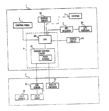
~çf~in~ now to Figs. 1 ~d 2, a main bo~y 1 cQnnectc wi~ an map Sc.~nnF!r
2. Ma~n body 1 iIlclu~es a con~ol c~ vhich ;n~ des a CPU 60 and a memory
c~n~ol c~cuit 61 with an i~ ge ~e . Co~ol circui:t 6 receives use~ c~mm~n~l.c
fi~om ~ con~l pa~el ~ f~d GPS po~on ~;ta ~om a GPS recei~el 3 and ~ 3~.
1 o a di~pl~ circuit 40 coInmllni~tes wi~ corlt:rol c~r'~t 6 ~o ~ e ~ displ~y 4 ~ig. 27).
A po~er CilC~it 64 pow~rs conn~t tihe de~rice. Optionally, a compass 7 m~y a~so
provide d~ta ta contt4~ circui~ 6; ~e ~hed l~ne ~ Nee~ ~n,~.l.h~s 7 a~d con~ol
circu~t 6 m Fig 1 r~le~e~t~ ~at co~ cs 7 may be ei~er an indepenrlert unit or
connert~ eret~.
la ~ap sc~ 2 col~necls to mam body 1 tllr~u~l a cable 29. Map sc~r 2
inr.l-ldes a li~ht sou~ 0 for ill~ to ~ a map ~, a li~t ~d~ 21 (e.g., a fib~ optie
cable~ wbich L~ ~reS arld gui~es lig~t reflec~d ~am map 9 to a line sensor 2~ (e.g.,
only a ray of CCD~s,) ~at reads light c~E~lg ~m l~ht gui~e 21, and a guide r~ller
enco~er 2~ ~t measu~ he ~ist~llce by which map scanner 2 moves aloIlg map ~.
2 o Con~ol arcuit 6 ~eeei~s ~e dstasignal~ ~om li~e sensor 22 a~d ~de roller e~coder
23 and ~tores the same as se~e~t;al ~a~e data ~n the ~e m~nl~ry of memory
circuit 61, ~)isplay 4 displays an im~ge of map 9 ('~e map image~ es~onding
~o ~e ~ge d~ be maI) ~nage di~played by disp~a,y 4 has ~e same sc~le as map
9 (~lt~o~h ~e sGale rnay 1ater be ch~ng~d), ho~ever, since display 4 is usually
sm~lla ~an the m~p! ~e displ~ye~ ~ap image is ty~ically o~ly a porti~n of map g
CA 02222300 1997-11-26
P160~3.S01
a llser ~an cha~ he map imag~ to o~erpo~tiox~s of map 9 by use of'con~ol paIlel
. .
~ tthi9 pomt, the map ~age in memory con~ol circu~t ~ ~erely re~resents
image d~ta. The map i~nage mus~ ~L~ef~.~ be altgned tn tl:le existi~g ~ de aIld
s ]on~ de coordinate system to pso~de a refer~ce for GPS data. As a first step, ~e
latitu~e and lo~ de coordinates for one l~own pannt on ~e map aDd ~e scale of
the map i~age are ~ltc~.,d. This operation is ill~strated ~igs. 3(a~3(e) The map~ge LS shif~ed using co~trol pa~el ~ il a refere~e position a, for which l~ti~lde
and lot~ le values are slready known~ is displa~red on di~pla~ 4. a user ~e~ i~puts
o ~e scale of map 9 (e.g., 1 inch = 1 n~ile) and ~e latitude and ~ gihl~P coordiDates
forrefe~ence posi~on a (liigs. 3(a)~3(d)). When ~his data iBL~ r~d~ display 4 displays
c~oss hairs 44. T~e user alig~s cross hairs 44 wi~b ~efe~ence point a ~Fig. 3 (e)) aIlt
loeks ~e same thOEeto ~u~h as by pressi~g a~ ro~le key on co~ol pa~el 5.
C~o~kol c~t 6 the~ ~si~ hose coo.~ ates to ~he ref~rence po~nt a ~ the m~p.
~ si~in~ coar~.ates to ~ k~wn ref~ ce poi~t i~ pardcularl~ ~sefill whe~
~e device is not located at ~G~rc~ce point A. H~7..o ~, if the de~ce is located at
rer~re.lcc point ~, ~e coor~ ates can be simply qs~i~ed ~om ~e GPS si~
~lic~ l~se~l ~n E; igs. 4(a) - 4(e~. By u~ ~he control panel 5 a user shif~ ~he map image
to di~play refe,~ce point a, at w~ich ~he device ls loc~f d Con~ol clrcuit 6 displa~s
2 o cro~s ha~ 44 ~ollowin~ input of ~e m~p scale. The use~ aligns cross ha~rs 44 wit~
r, L,r~ue point a using control pa~el ~. Once ~1i~, b~ using ~he con~ol pa;nel 5,
~e use~ requ~4fq the GPS l~ de aIld longi~de coolJ;.~t~ or ~e cu~rent posi~Lion,and con~ol cwuit 6 assigns ~ese coo~dl,lates to rcfo~ ce pom:t a. Sillce GPS
coordin~t~-s are accurace to ~i~in ~everal fee~ hly acc~,.~e coord;n~t~.s are
25 ~ ned for ~f.,~enc~ po~nt a,
CA 02222300 1997-11-26
P16083.S01
If map g is dowr l~ade~ in per~ li~mRnt with the norfkern direc~on of map
9, ~en ~e inpu~ of ~e map s~ale ~d coordi~ates of referencepQ~ a is SUf~iGieIlt
to e~Pbli~h ~e l~t;tu~e aIId lon~nltk coord~te sy~tern for the en~re map im~ge.
H~wGver~ when s~ ~- "; ~ ~e image, it is unlilcely ~at 3 user will scan map 9 m~ml~1 Iy
5 ~ such pOEfec~ ~li~Tn~ wi~ tihe nor~em direction of map 9. Addi~o~al data may
~cr~for~ be nece r to e~tablish a coor~i,~le s~rste~.
I~ this s;~ tiPn~ ~he map image can be alig~ed u~ two reference points a and
B ~ sl~own in Figs. ~a3-5(g~. In Fi~. 5~a), ~e m~p iIIIa~e is sbi~ed no~r to di3play
.,f,.~ce poi~ts a aIld B. ~ Figs. ~b}5(d), ~e coo~di~l~ o~refe.erlce po~nt a are0 i~put ~d mAtt~ n~ ~ similarto ~e process desrnbe~ f~,rel~ce to Fi~ss.3(a~3(e). (~t ~s nated tha~ cross hair 44 caIl be positioned over ~e ~eference po~nt
before coordinates are e~hl~.d, ~d vice ~ersa ) In Figs. S(e)-5~g), lhe process iç
repeated f~r r~ ce po~t B. Of course, if points a ~d B are too ~ apart to be
displayed toge~ n ~e sc~ he ~a~ scale ~ be adjusted, o~ ~e user c~ move
the displayed image to refe~ence point B a~er ~eference poi~t a is e~t~icd.
If the ls~tit ld~ a~d lan~ de cool~li"ate~ ~ refe~e~ce positinn~ a and B a~ not
know~, ~e~ a user can load t~e coordin~es ~ e C3PS sig~l by tlaveling to bo~
~loc~ nc. ~e~e~n~ to Figs. 6(a)-6(c), ~e user ~st b~ s the device to l~f~,r~
point a, do~vnloads the GPS coo~ or refereT~ce po~on a~ and align~ ~e
o coordina~e cross hai~s 44 w~ ~ce p~i~t a on the map image. In ~igs. 6(d)~6(f),the u~er ~avels to reference p~int B ~d re~e~ts ~e lJlOCC.51\. I~e cross hairs ~ould
also be aligned wh~ the rcf~~"~e po~t before ~e GPS dat~ is received.
Of course, ~e user ~ay combi~e tlle abo~e processes by ll~pullillg ~e known
coo..L~es for either reference point a ~r B, ~nd using the GPS ~oordina,tes for thR
2s o~e~ ,eL.~ce point.
CA 02222300 1997-11-26
P16~83.S01
Once ~e coo~di~ate data ~s e~te~ bave, con~ol circuit ~ establishes a
P and lon~de ~ a~e system fior ~e map image based on refere~ce points
a aIId B. Fur~er, si~ce CPU 60 can de~e~;ne the scale ~f ~e map ~om ~e
coordinates of reference poi~ts a and B, ~e user need ~ot enter the ~ap ~cale.
Coordinate ~y~t~lls ma~ be established in several ways. In one method, tihe
co~r.l;"~t~ syst~ LS set u~mg latitude and l~n~ de ~or ~he area ~overed ~y ~c ma~;
cu~e~ o~iliO~ hus displayed based on ~e l~ti~ and lhn~ e ~f ~e syslem
itselfas the ref~ noth~ me~od, points on t~le map ~é ~ 1 cool lu IAtes,
and c~ent position ~s disp1ayed us~g one or r~ore of ~e ~omts as ~e l~r~
It is ptcf~le t~at the ~o,~ border of ~e m~p ~lign ~vit~ ~e upper po~on
of ti$play 4. ~Iowe~er, al~ough the map ~ge is now ?li~l in the l~tihlrle and
lon~itude coordina~e system, ~he ima8e i~elf may sti~l be displayed at an amgle o~
display 4. As ~hown ~n Fig. 8, con~ol circ~it 6 <~et~ n~s the dif3~erence 0l betwee~
an angle r~ de2ived ~om the a~ual cow~ es of reference po~itione a and B, and ~nangle ,B, de.ived ~om ~eir poC;~jQnc ~s ~hey appear on ~e map image. Co~trol cirG~
theD rotates ~e map ~ge -~ about re~ere~ce po~nt a such ~ e northel:4
direction of ~e map is aligned u~ e ~w~rd direction ~f d~splay 4. Irl the
att~rn?*ve, conlrol circuit ~ ~an simply re display thG map in ~e des~red ~ Pl~the abov~ e~nbo~lim~ au~er must ei~er know~he co~di~tes of r~ ,.ce
pointE~, or o~se be st~n-lin~ oferen~e point B to o~tain coordina,t~s ~om tbe
GPS sigr~ f ~e user does not bave t~e coordinates and ca~not reach re~e~e
p~t B~ the ma~ image can be oriented us~ng ~nly ~e coordin~es o~re~rence
point a, ~he map ~cale, and bea~ course ir~fnrm~t;o~ (cour~e data) ~om ma~ 9.
Spe~ifically, ~e ov~whelming n~ajonty of maps are pr~nted ~ith some ~:ype of
2 5 ex~ss i~dication o~ a re~erence direction (~pically "Nt " fo~ nor~, or ~the~unse
CA 02222300 1997-11-26
'_
P1608~.S01
have a bor~er of 1~e ma~ ~li~ed with ~is refaence directio~, ei~¢r o~these may be
used to onent t~e ma~ imsge.
Spe~;fic~lly, ~e ~ap s~le and coor.lil~ates for ~ ce p~int a are entered
as shown in ei~er Figs. 3(a~3(e) o~ 4(a)-(e~. If ~e image is ~ dy p~ rl uri~ ~e
n~, ~ the user ca~ so in~ te~ ~he coo~ ,atc system is ~en e~h~ erl ~rou~h
the coordi,~ate ~f ref~ence po~itinn a~ and ~e map scale. ~f t~e map ~age is not~li~e~ con~ol cir.cuit 6 pro~ides a bea~nglcourse a~ow 45 supc~s,~osed on the
map ~m~ge as shown in Fi~. 7(a), Th~ use~ ca~ ~e~ rota~e the be~rin~/course arrow
45 to align wit~ ~e ~re.~llGe direc~ion on the map image (e.g., a pri~ted
o '~Nt"directio~orthe ed~e o~map 9; if not in~he displ~y, ~e user can move ~e map
image~ con~ol panel 5). Once ~e user indica~es ti~at ~row 4~ is ~ti~n~l w~th ~e
r~felc~ce direction~ control ci~cuit 6 moves tbe displa~ of ~e map image (or re-di~ay ~e image) such that re~erence direction is ~ l wi~ the u~ ud d~rection
of ~ y 4. For eY~ple~ if ~user ro~es arrow 45 1j~ clocsL~e as show~ in ~igs.
7(a) and 7(b) and locks this course in (by use o~e co~'aol panel ~), ~en co~ol
circwt 6 will rotate the m~p image 1~~ counterclockwise (i.e., -15~). Since the
ref~nce direc~ion is ~ ,~ly north, ~is ali~ ~e ~OI~I~,.1L direction ~fthe map
-~n~ ~e top of display 4.
If ~e map does notpro~ide ~ny usefi~ f~ ce directian, ~a~ a user can rel~
upon m~ tie no~ as displayed by compass 7 (or ano~er c~ is). Optionally,
co~ol ~t 6 ~nay be pro~ided wi~h a ~ode to correct for a~y di~rc~lial bet~een
t ~ ~orth and lrue ~or~ ~sed on ~e known di~ ce fo~ lcf~~~ce p~t a.
If col~r~C~ 7 is ~ çh~d such ~t it prov~des d~ta to con~ol c~rcuit 6, a user
can align m~ tic nor~ on ~e map smage wi~ ~e uy~d ~irec~o~ of ~he display
2 5 4 based on ~e an~le ~ betwe~ rue north Nt of ~he map inlage (tet~ine~ ~rhen ~e
cool-l,nate system is establisbed~ and m~n~iG nor~ Nm (Fig. 9). T~ 1ion on t~e
13
CA 02222300 1997-11-26
'
P16083.SO1
angl~ ~ is storea by con~ol c~it 6. :By e"t~ing a ma~nP~;c north display mode, ~e
~ap image will ~otate by an angle ~ lign witb rn~lic ~o~th.
Arlo~her me~od for ~tPnng coo.Ji~ datais shou~ igs. 10 arld 11. ~ap
~ can be pro~ided wi~ pr~nted l~t;tllcle a~d lon~i~de r~erellce line~ which are
s~nn~d and reco~ed ~y co~ol circu~t 6. Prefesably, ~e embodiment of Pigs. 1
and 2 can differentiate ~e ref~rence li~es ~om ~e rest of ~ map.
In ~e ~It~m~;ve, the ~ re~cc lines are provided in a di~,~nt co~ om
rern~in~er of map ~. Usmg a seco~d light ~uide 21a and ~ second Isne ~e~so~ 22~ in
co~nhin~ion ~it~ an ~p~cal filter 24 tuned to ~e color of the refe~ence lines, ~e
co~rd~nate li~es and ~SSOG~ ~te~l vah~es c~n be reco~ed as separate a~d distiIlCt ~om
o~ elen~ents of map 9. T~ ma~ image and coo,~ ~ystem are ~ltom~tic~lly set
ug~g the pre-p~inted referen~e lines,
Once ~e m&p is set in the coo¢d~ate system accordi~g to a~y of ~e above
proe~ s, contr~l c~t 6 select~ p~4~ia~ p~on of map 9 as ~e map image,
and displ~ys tbe cu~e~t poltion on the ma~ ~mage~
e prer~".ed embodim~t of ~e inv~ on, map sce~ e~ 2 conn~cts
pormA.~. J-~ly to IIlaill body 1 via a cable 29 (~ig. 2~. As shown in Fig. 13, c~ble 29
may be detachable~ such ~at a user nee~ ~ot lransport map scanner 2 ~nce ~e desi~ed
map 9 ~ scanned ~to memoIy,
2 o The use of a separate ~ body 1 and scan~er 2 allows for s~nn-~, 2 to be as
w~de as possible to ~ ~ze ~e ~i~e ofthe map w~ich may be sc~nn~d in a single
pass. Ho~ever, if ease of portabili~7 is a pnoritg, a c~ a~ co~fi~-ation in which
ma~ body 1 ~nd sc~ 2 a~e arl i-tte~l U~l~t iS sho~n in Fig. 12. ~ ~is c~se, it ma~
~e several passes of sc~ arious se~tion of a larg~r map, ~ll~u~.o~
co~trol 6 j~ns the m~ xection as ap~ iate. For example, Lef~. ~ ,~g to Fig. 14, a
use~ c~uld first s~n se~tion M1 of ~nap ~ ~d~en overlappi~g sec~o~ M2 of m~p ~.
1~
CA 02222300 1997-11-26
P16083.S01
Control circu~t 6 then joins l~em toge~er b~sed Oll COInn~AOn re~erence li~es a~d~or
positions ~o fom ~e combined ~a~ of Fig. 10 using the reference lines. In ~e
~hP~l~ti~7e~ e~ch m~ .~ osl ~ould be aligne~ dividually, wh~c~on control 6 ~ill
them usi~g ~e coordma~e systenL
~ s can be se~ by the abo~e~ the ~ t inYention pro~ded mlmerous
advantageous over the prior art. Sinee ~ere is no Cr) dri~re to oper~te~ ~e preserlt
inverl~on is ~m:~ll~, lighter, and use~ less power ~a~ ~av~ga~ian de~ices whi~h u~lize
CD's. The ~tet maps are less e~v~i.fe ~ s~olldil.g maps on ei~r CD's
or IC cards. The level o~ detail of the desired map can be saperior to that
10 cQmm~cially a~ailable o~ ei~e~ CD's or IC cards. F~ally, ~e priuted Inap is only
used d~g setup, and thus ~e use~ ~eed not spread out a map every t~me to check
the cu~rent position.
~ ano~er ~n~bodin~t ofthe invention show~ in Pig~. 15 8nd 16, m2p S~.~nner2 is re~l~Ged ~ a data c~...,K~ n interface 8. Da~a co.~-n~ .icati~n in~rf~
~ ca~ recei~e map ~age da~a ~lrou~h a fa~ mo~em 80 o~er a standard telephoIIe 1~ne
81 by pluggLng in~ any t~ hntle jack. In'~ may ~Iso o~ on radio ~raves
~ing a wil~less receiver 84 wi~ an A.~ R 85 as in Fig. 17~ or i~ .rcd~ncmi.c.~ion
using a photoele~iG convert~ 86, a luminous cl~ (i.e., light ~ource) 88, and
photo se~sot 87 as m ~ig. 18.
As shown in Fi~. 19, a digital int~rf~ce 82 for c~n~ction to a co~nputer or
COlll~Ut~ per~phe~al ap~&~us caIl also be used. Map image dat~ stored in t~e
c~m,o.-l~. is do~loade~l throu~h ~is dig~tal interface 82 to read map image datastored an a CD-~OM connected to ~e comp~.,~.
In ~e embofl ( of Fig. 20, map image d~ta can ~lso be read ~m an IC card
using an IC ca~d ~nte~face 83. Ma~ ge data sto~ed on ~e I~ card is not ~ir~ly
CA 02222300 1997-11-26
' '
P1~083.S01
used, ~a~er ~p image data stored on multiple IC ~a~ds is combined in memo~y
circuit ~1 .
W~ile ~e ulven~don has beell desc~ibed with ~e~eDce ~o several ex~npl~y
embot~;., .F,nL., it is lln~ood ~ha~ ~e wo~ds which ~ve bee~ used here~ OEe ~o~ds
~f d~c~i~ion arld ilhlskation, ~a~er ~an words of l~tations. Charlges may be
mate, w~in ~e pu~iew of ~e pend,~g clair~s, as w~out affect~ng t~e scope and
sp~rit of ~e invention and it~ aspects. While ~e in~entio~ has been descrlbed here
~i~ reference to p~ic~lar means~ m~teri~l~ and embo~im~nh~ l~e in~ention is not
inf~nd~d to be lirni~ed to ~he p~cular c~ osed herein, ra~er, ~he invention ~t~nds
0 to ~11 r,~ ly equ~valent s ru~res, met~ is and uses, such at all w~ ~e ~cope
o~e appended cl~s.
By w~y of non-limit;n~ eY~nlrle, as woul~ be a~ to o~e of or~iDaIy skill,
control panel 5 and ~e orde~ of steps may be modified wi~out d~pn~l.g l~om ~he
scope or spiri:t of tl~e ~rention.
Fore~ le, controlpa~el 5 pleferably includes four dire~ollke~s (up, do~,
ieft and right), a stsrt key, an end key, a re~lced s&ale key~ a c~ tposi~ion key, a
bearing key, and a nlvn~ key pad. Pressm~ the s~rt lcey enters a mode in which
~e user enter~ ~e coo~dinate data for the reference poin~ wi~ ~e mlme~ir~l key pad.
Press~ng~e b~n~ key L$~1ay~ row 45 a~ in Figs. 7(a) a;nd 7~b). Press~glhe end
2~ ke~r~s~ed~taand/orclose~ em~de. Pressin~ eIeducedsealekeyadjust~
~e scale of the map image. Press~g ~e c~ent posi~oIl key causes ~e de~ice to
retrieve ~e ~PS coordinates a~d displa~ tbe curreot posi~o~ on the dis~la~
su~e~ o~cd ~ ~e map im~ge~
Ho~.~Y r, although ~he present inve~tion ~ izes su~ ke~s, t3:e prese~t
inve~o~ coul~ be ~eplaced wi~ a mouse buttan~ ~ngerpad, joystick, keypad~ rotarydial, ~r simila~ ~evice. Similarly, data could be entered m~ml~lly ~rough dif~ t
16
- CA 02222300 1997-11-26
P16083.S01
modes, o~ seq~lenti~ly under co~ on~ ;n~ Further~ t~e order i~ which data
is entered i~L ~e p~ d embo-limPnt may be ea~ily a~lls~ed.
~ } yet ~n~t~r e~.ample, display 4 of ~e present ~nven~on is preferably an LCD
di~lay. Ho~.cY~, ~e invention is not so limite~ and a~y ap~,oprlate ckclr~ ic
5 displa,y ma~ be used.
The ~ l ap~ tion r~lates to subject matter cont~ine~ in J~p~nese Patent
Applic~;ons 8-314,380, filed Navember 26, 19~6, ~d 9-106,503, filed April 23,
1~7, both of whic~ a~ ez~pressIy ~nco~or~ted by r~f~ ce herein in ~eir entireties.