Note: Descriptions are shown in the official language in which they were submitted.
CA 02222570 2000-07-31
sac sic. __-C=a:;C
,- G= ;-~- ~~t~~~ T GN
'~L~Ti~L:.c. lLTirL-'u~E S_s'~'~ .r, T ~ ~t -ya~r s-r~~~r ay ~~GD
,~.,A.G~CG.~OL~~ O~ 'I'~s. iaN
The present invention relates generally to
satellite co~~n~catioas_ More particularly, the
preserzt inveritiors relates to a method and system of
satellites which are capable of prov?dsg continuous
unbroken links between two or more satellites c~snosed
at different altitudes, including one or more satellites
. at Low Earth. Orbit, Medium Earth Orbit; and
Geosynchronous Orbit or any altitudes there between..
Co~unication and data satellite relays are used to
facilitate the transfer of information between. two or
more locations. The locations could be satellites or
ground stations. These "users" may need to use a relay
IS method due to'any.of the following reasons: (1) the
ea-rth is between the user and a location with which the
user wishes to conunua_i.cate; (2) the user cannot r~oin.t in
the direction of its'i.ntended Location, but is able to
. po int to a v relay; . . a.nd ~ ( 3 ) the us er does no t have the '
24 Power. or equ.i:pmeat .to con ,~~cate directly with. the .
desired reacote Iocation_
I
CA 02222570 1997-ii-2~ Doc- _ No. 16-0280C
',
- The principal factors of consideration for
satellite relays are the following: (1) cost; (2)
effectiveness (such as, data rate, coverage, number of
users, and so forth); (3) complexity; (4) the burden on
the user in terms of the amount of power and specialized
equipment which is required by the user to communicate
with the satellite relay; (5) transition from old relay
systems to a new one; (6) and flexibility.
Geostationary satellites may be used as relay
stations since the geostationary satellites would be
stationary over the earth and thus the ground stations
could use antennas with fixed orientations, pointing at
the satellites. Their advantage is that ground users
see a relatively small change in the line-of-sight (LOS)
from the users to the geostationary satellite relay over
time. Also, geostationary satellites are more difficult
for an adversary to destroy due to the greater energy
required of the intercept vehicle and the long warning
time.
However, geostationary satellites are not without
disadvantages in a communication relay application.
They require large boosters to launch to the high
geostationary altitude of 22,300 miles (35,900 km) above
the equator; and due to the high altitude, they require
large antennas to transmit and receive radio frequency
(RF) signals. Likewise, users are required to carry
larger antennas to transmit and receive signals with a
satellite at the geostationary altitude.
2
CA 02222570 1997-il-2~ Doc~ t No. 16-0280C
- - Other disadvantages with geostationary satellite
relays are that the geostationary orbit is relatively
crowded as it extends around the equator and at least 3
geostationary satellites would be required to cover a
global distribution of ground stations. Also, spares
are expensive, and an inclined-orbit would be needed to
provide service to the ground at high latitudes. The use
of a geosynchronous satellite, with its inclined orbit,
would virtually eliminate the fixed orientation user
antenna advantage and would require more satellites to
provide good coverage to all latitudes.
In general, geostationary satellites with any type
of satellite link suffer these disadvantages. In the
field of the present invention, a satellite link entails
a unidirectional or bidirectional transmission of
information between a satellite and another entity via
radio frequency, laser, or other suitable signal
conveying techniques. The other entity may be another
satellite, a ground station, or some other entity
capable of transmitting or receiving signals through
space, such as an airplane or space station.
Satellite relays at lower altitudes could also be
considered, such as Low Earth Orbit (LEO), Medium Earth
Orbit (MEO), or Highly Elliptical Orbit (HEO). However,
lower altitude satellite relays require more satellites
to cover the earth to provide continuous service. When
more than one satellite relay is used in coordination to
3
CA 02222570 1997-11-27
Doc : No. 16-0280C
cover the earth, the multiple satellite relays are
collectively termed a "constellation".
Lower altitude satellite relays are also more
vulnerable to attack and have relatively high angular
LOS rates and more frequent "make/break" link
requirements. HEO satellites operate most of the time
near geosynchronous altitude, with many of the same
advantages and disadvantages of geosynchronous
satellites. HEO links must be made and broken, although
to less frequently than at LEO or MEO altitudes. Lastly,
to link with a ground station, the lower altitude
satellite relays may need to establish communication
links with other satellite relays in their constellation
or require more ground stations around the world. The
15. cross-linking among other satellite relays in the
constellation results in a complex series of routing and
making and breaking of communication links.
These systems route the signal through the use of
cross-links, which are intelligent switches and routers
20 on board each satellite, among many satellites. This
"intelligent switch/router" in space is a major drawback
since these satellite systems have to point at other
satellites and have the complexity of determining who
should be the recipient satellite of the message. The
25 situation becomes even more complex if the selected
recipient satellite is overloaded with other data
transmissions. Such a situation forces the sending
satellite to reroute the message to another satellite.
4
CA 02222570 1997-11-27
Doc. c No. 16-0280C
Therefore, it is an objective of the present
invention to provide a satellite relay system that is
less complex, more flexible, more robust in handling
potential problem conditions, and lowers the user burden
to perform the relay function.
It is another objective of the present invention to
provide a satellite relay system in which communication
links are not interrupted, and therefore avoids the need
for a first satellite to break its communication link
with a second satellite and to establish a new link with
a third satellite as the second satellite moves behind
the earth relative to the first satellite.
It is a further objective of the present invention
to provide a satellite relay system using smaller, less
powerful satellites to act as relays.
It is another objective of the present invention to
provide a satellite relay system having uninterrupted
communication links without necessitating the use of
satellites in geosynchronous orbits.
It is a further objective of the present invention
to provide a satellite relay system providing
uninterrupted communication links through a system
including two or more satellites at different orbital
altitudes.
It is another objective of the present invention to
provide a satellite relay system that provides
uninterrupted communication links even during failure of
5
CA 02222570 1997-11-27
Doc c No. 16-0280C
- system satellites and periodic maintenance of system
satellites.
BRIEF SUMMARY OF THE INVENTION
In one embodiment, the present invention provides
one or more geostationary or geosynchronous (GEOS)
satellite relays in synchronization with one or more
medium earth orbit (MEO) satellite relays to produce
continuous links between these two sets of relays. Such
a synchronized arrangement of satellites has the
advantage of requiring less user burden since earth-
based users do not need to transmit to GEOS altitudes.
This type of hybrid system (that is, one or more MEO
satellites synchronized with one or more GEOS
satellites) accepts the burden of transferring the
signal up to GEOS altitude and back to the ground.
Also, the hybrid system is more robust since an
interruption of one of the relay communication links
will affect the system less than an interruption in a
pure GEOS-based satellite relay system. Moreover, the
hybrid system uses fewer GEOS satellite relays (as few
as one) but can still provide continuous links with the
ground because of the unique synchronization between the
GEOS and the MEO satellite relays. Consequently, cross-
links are not required between MEO satellite relays,
even though such cross-links could be provided in the
appropriate application.
6
CA 02222570 1997-ii-2~ Doc ,. No. 16-0280C
- The present invention may also be configured to
provide continuous line of sight above-the-horizon (ATH)
communication links. ATH line of sight communications
links or extensions of such links never intersect the
earth. ATH communication links have the additional
advantages of: (1) avoiding interference in either
direction from light or radio-frequency sources on earth
or from GEOS radiated interference to terrestrial
communications; and (2) reducing the potential for
intercept of a signal by terrestrial sites.
The present invention may be used for several
different types of communication applications. For
example, in the case of military communications, a
dispersed user set (such as troops in the field or
15. military satellites) need information from one or more
ground stations, or information from a user in the field
may need to be transmitted to those ground stations.
The present invention could also be used for general
commercial purposes if dispersed users need to
communicate with one or more designated ground stations
within sight of the GEOS satellite relay(s). Further
communication to and from users on the ground could be
accomplished by relaying the information from the ground
station back through the MEO-GEOS satellite relay chain.
The communication data could be any form of
communication data, including without limitation, video
and other high data rate signals. The communication
signals could be RF signals, light-based signals (such
CA 02222570 1997-m-2~ Doc .:. No. 16-0280C
as lasers) or any other suitable LOS transmittable
signal.
Another envisioned user of the multiple altitude
satellite system could be a set of satellites placed in
a MEO position that is synchronized with GEOS satellite
so as to be directly and continuously linked with the
GEOS satellite. The GEOS satellite would then relay
information from the MEO satellites directly to the
ground. The advantage would be a single-hop
l0 communication relay. Also, the need to reconnect a link
after it is broken, as is the case in most relays to
GEOS satellites, is eliminated since the users
themselves are now synchronized with the GEOS
satellites.
Another application of the present invention
involves a non-geosynchronous orbiting satellite
constellation (such as a MEO satellite constellation)
being cross-linked with one another and synchronized
with one or more GEOS satellites. The MEO cross-links
could be used for low data rate information transfer,
such as hand-held voice purposes, where the relatively
small antenna or laser optics size and low power
required by the low data rate would be advantageous.
The satellite constellation's synchronized link with the
GEOS satellite could then be used for high data rate
information transfer, where continuous links are
important.
8
CA 02222570 1997-ii-2~ Doc t No. 16-0280C
Another embodiment of the present invention
provides one or more high-orbit non-geostationary, non-
geosynchronous satellite relays in synchronization with
one or more low-orbit satellite relays or intermediate
orbit satellite relays orbiting at an altitude between
the altitudes of the low-orbit and high-orbit
satellites) to produce continuous links between these
two sets of relays. Such a synchronized arrangement of
satellites has the advantage of requiring less user
burden since earth-based fixed and/or mobile terminals
need not communicate directly with the high orbit
satellite. The intermediate orbit satellite relays
transfer communications signals between earth-based
fixed and/or mobile user terminals and high orbit
satellites, thereby relieving earth-based user terminals
of the burden of communicating with a high orbit
satellite. This alternative embodiment requires smaller
launch vehicles and is more robust since an interruption
of one of the relay communication links will affect the
system less than an interruption in a pure
geosynchronous based satellite relay system.
Yet another embodiment of the present invention
provides a satellite system providing continuous
unbroken links which are not limited to high-orbit
satellites, intermediate-orbit satellites and low-orbit
satellites. Instead, a continuous data link may be
established by a constellation of satellites arranged at
a number of discrete altitudes.
9
CA 02222570 1997-11-27
Doc c No. 16-0280C
- Still another application of the present invention
involves a GEOS satellite observing a MEO satellite for
detection of any problem conditions with the MEO
satellite. The GEOS satellite being synchronized with
the MEO satellite in accordance with the present
invention permits uninterrupted observation of the MEO
satellite due to the continuous line-of-sight that
exists between the two satellites. Thus, it should be
understood that the present invention is applicable to
l0 satellites whose functions may not include communication
or data relaying. While the term "relay" is repeatedly
used in this specification, it should be understood that
the present invention is not limited to satellites whose
primary function is to relay information.
For example, a system of a GEOS satellite and one
or more MEO and/or LEO satellites may provide the
function of sampling solar radiation. For the purposes
of comparing the GEOS satellite's sampled solar
radiation data and the MEO or LEO satellites' sampled
solar radiation data, the MEO or LEO satellites send
their sampled solar radiation data to the GEOS
satellite. The GEOS satellite then processes all of the
sampled radiation data and sends the results to the
ground. In this example, the features of the present
invention are used for more than relaying data.
Furthermore, it should be understood that a ground-
based user is not needed in the present invention. The
CA 02222570 1997-11-27
Dock ~ No. 16-0280C
end user may in fact be another satellite, space station
or otherwise mobile user.
BRIEF DESCRIPTION OF THE SEVERAL VIEWS OF THE DRAWINGS
Figure 1 is a three-dimensional view depicting a
two-HOP multiple altitude satellite relay embodiment
according to the present invention with two Medium Earth
Orbit satellite relays and one GEOS satellite relay.
Figure 2 is a three-dimensional view depicting the
synchronization relationship employed by a multiple
altitude satellite relay system according to the present
invention.
Figure 3 is a graph showing initial GEOS satellite
relay equatorial angle from a MEO satellite relay plane
versus minimum tangent altitude above 75 kilometers for
valid GEOS satellite relay ranges for an embodiment
employing an eight-hour MEO period.
Figure 4 is a graph showing initial GEOS satellite
relay equatorial angle from a MEO satellite relay plane
versus minimum tangent altitude above 75 kilometers for
valid GEOS satellite relay ranges for an embodiment
employing a twelve-hour MEO period.
Figure 5 is a Cartesian world map showing the path
that a ten MEO satellite relay embodiment traces upon
the earth.
Figure 6 is a polar plot showing the line-of-sight
between a ten MEO satellite relay embodiment and a GEOS
satellite relay as viewed from the MEO satellites.
11
CA 02222570 1997-11-27
Doc ~ No. 16-0280C
Figure 7 is a polar plot showing the line-of-sight
between a ten MEO satellite relay embodiment and a GEOS
satellite relay as viewed from the GEOS satellite.
Figure 8 is a graph showing the earth-surface
coverage that can be achieved with a ten MEO satellite
relay embodiment according to the present invention over
given latitude and longitude locations.
Figure 9 is a graph showing initial GEOS satellite
relay equatorial angle from a MEO satellite relay plane
versus minimum tangent altitude above 75 kilometers for
valid GEOS satellite relay ranges of an eight-hour MEO
period for an above-the-horizon embodiment according to
the present invention.
Figure 10 is a graph showing initial GEOS satellite
relay equatorial angle from a MEO satellite relay plane
versus minimum tangent altitude above 75 kilometers for
valid GEOS ranges of a twelve-hour MEO period for an
above-the-horizon embodiment according to the present
invention.
Figure 11 is a three-dimensional view depicting a
one-HOP multiple altitude satellite relay embodiment
according to the present invention with one lower-orbit
and one higher-orbit satellite where the higher orbit
satellite is not necessarily at GEOS altitude.
Figure 12 is a three-dimensional view depicting a
three-HOP multiple altitude satellite relay embodiment
according to the present invention with two low-orbit
12
CA 02222570 1997-ii-2~ Doc ,. No. 16-0280C
- - satellites, one intermediate-orbit satellite, and one
high-orbit satellite.
DETAILED DESCRIPTION OF THE INVENTION
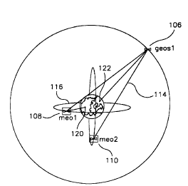
Referring to Figure 1, a first embodiment of a
multiple altitude satellite system according to the
present invention is shown. More specifically, Figure 1
shows a configuration of one GEOS satellite relay (geosl
106)and two MEO satellite relays (meol 108, and meo2
110). The geosl 106 is continuously in line-of-sight
contact with meol 108 and meo2 110.
A user 120 who cannot communicate directly with a
remote earth-based station 122 can communicate with
meol 108, which in turn is linked continuously with
geosl 106 satellite relay. Since geosl 106 is in
continuous contact with the earth-based station 122,
geosl 106 can forward the communication from meol 108
to the earth-based station 122.
Although a MEO satellite relay has to point its
antenna over a large portion of the sky to link with the
GEOS satellite relay, its link is not broken, so it does
not have to spend time acquiring another relay. Also,
the track path repeats, thereby decreasing the
complexity of the tracking algorithm.
One synchronization parameter of the MEO and GEOS
satellite relays is the ratio of their periods. A
continuous line-of-sight between a MEO satellite relay
and a GEOS satellite relay is achievable for several
13
CA 02222570 1997-m-2~ Doc t No. 16-0280C
ratios that represent integer factors of twenty-four.
For a polar lower orbit, the ratio of the periods may be
an exact integer, however, inclined orbits precess
slowly. Because of the precession and other
perturbation effects, the ratios of the periods slightly
deviate from an exact integer to provide the proper
phasing.
In the preferred embodiment, the period ratio
between the GEOS satellite relay's period and the MEO
satellite relay's period is 24:8 or equivalently 3:1. A
3:1 period ratio is achieved when the period of the GEOS
satellite relay is three times the period of a MEO
satellite relay. Thus, a GEOS satellite relay period of
twenty-four hours and a MEO satellite relay period of
eight hours will produce a 3:1 period ratio.
It must be noted that the GEOS satellite relays in
the present invention refer to geosynchronous satellites
in general and not only to geostationary satellites.
The distinction between the two is that a geostationary
earth orbit is a geosynchronous orbit with a zero degree
inclination -- that is, an equatorial-only orbit.
Consequently, a geostationary earth orbit is a specific
type of geosynchronous orbit. Moreover, polar orbits
are used as examples for the MEO satellites, and the
equatorial GEOS orbit is used as an example for the GEOS
satellites. Neither the MEO satellite relays nor the
GEOS satellite relays are limited to these inclinations.
In fact many more combinations of GEOS and MEO
14
CA 02222570 1997-11-27
Doc t No. 16-0280C
satellite relays are possible, including varying the
number of GEOS and MEO satellite relays, the number of
orbit planes of GEOS and MEO satellite relays, the
inter-orbit and intra-orbit phasings of the MEO
satellite relays, and the inter-orbit and intra-orbit
phasings of the GEOS satellite relays. For example, it
should be understood that the GEOS satellite relay could
be in a polar orbit, or at an orbital altitude which is
non-synchronous to the earth. The present invention can
be practiced with the MEO or GEOS satellite relay orbits
being circular or elliptical. Also in many MEO
satellite relay configurations under the present
invention, proper placement of the GEOS satellite relays
will allow each of the GEOS satellite relays to
continuously view all of the MEO satellite relays. MEO
satellite relay constellations of 3, 6, 9, or 12 MEO
satellite relays with three GEOS satellite relays being
120 degrees apart are examples of this aspect of the
present invention. In such a configuration, each GEOS
satellite relay can provide complete backup of the other
GEOS satellite relay. While Figure 1 shows the use of
two orbits for the meol and meo2 satellites, it should
be understood that both of these satellites could be in
a single orbit. Similarly, it should be noted that the
present invention is not dependent upon the number of
MEO orbits, as the number of orbits may be modified
(such as 1, 2, 3, 4, and so forth).
CA 02222570 1997-m-2~ Doc t No. 16-02800
- These various configurations can achieve a
continuous line-of-sight when: (1) the period ratio is
synchronized; and (2) the distance of the line-of-sight
from the earth is synchronized with the position of the
GEOS satellite relay and the inclination angle of the
MEO satellite relay. A more detailed discussion of the
synchronization involving the distance of the line-of-
sight from the earth begins at Figure 2.
Figure 2 shows a polar MEO orbit plane 160 and an
equatorial GEOS orbit 162. In this example, the
initial position 164 of the MEO satellite relay 166 is
assumed to start at the equator and ascend North. The
initial position 168 of the GEOS satellite relay 170 is
assumed to start at an angle "Mo" 172 from the polar
MEO orbit plane 160. As the MEO satellite relay 166 and
GEOS satellite relay 170 move in their respective
orbits, a line can be drawn between them which is the
line-of-sight (LOS 174).
The LOS 174 is not obstructed by the earth 176.
The altitude of the LOS 174 above the earth 176 is
called the tangent altitude 178. If the tangent
altitude 178 becomes negative, the LOS 174 would be
broken. If the MEO satellite relay 166 is between the
earth and the GEOS satellite relay 170, then extension
of the LOS 174 will intersect the earth, causing the
tangent altitude to be negative. However, the MEO
satellite relay 166 is obviously in view and in this
case, the LOS 174 is not broken. The minimum tangent
16
CA 02222570 1997-11-27
Doc. :. No. 16-0280C
altitude over one GEOS satellite relay orbit is
determined for an LOS 174 since that number will
indicate how close a satellite relay system is to losing
its LOS 174. Correspondingly if the minimum tangent
altitude is large, then the relative positions of the
MEO satellite relay and GEOS satellite relay can be
varied greatly before the tangent altitude 178 was
reduced to zero and the LOS 174 lost.
Figure 3 shows the relationship between the initial
GEOS equatorial angle from MEO plane ("Mo") and the
minimum tangent altitude of the LOS of an eight-hour MEO
circular orbit. These relationships are shown for a
range of MEO inclinations. The orbit configuration of
Figure 2 corresponds to the tepee-shaped curves labeled
"90" degrees inclination. Any point under the tepee-
shaped 90 degree curves represents an initial GEOS/MEO
satellite relay relationship that results in an
uninterrupted LOS. Thus, the GEOS satellite relay's
initial angle (Mo) could be within the three ranges of
330-30, 90-150, and 210-270 degrees, and would still
maintain a continuous LOS. These ranges become slightly
larger if the MEO satellite relay orbit is inclined at
70 degrees, and are smaller at MEO satellite relay
inclinations of 50, 40, or 28 degrees. The minimum
inclination of 28 degrees is significant in that it
allows a wide range of MEO satellite relay orbits at
inclinations from less than 28 to 90 degrees. The large
range of possible configurations indicates that similar
17
CA 02222570 1997-ii-2~ Doc t No. 16-0280C
continuous LOS results would be obtained for certain
classes of elliptical orbits.
Figure 4 shows similar data for a twelve-hour MEO
satellite relay orbit. For the MEO satellite relay
inclinations shown, the inclinations that provide the
largest minimum LOS values are at 50 and 70 degrees.
This indicates that the largest value lies within that
range. Also instead of three "tepees" as in the eight-
hour MEO satellite relay orbit graph, the twelve-hour
MEO satellite relay orbit has four "tepees", each in
approximately 40 degree range. Thus, Figure 3 and
Figure 4 can be used to determine a MEO satellite relay
position and GEOS satellite relay position that will
result in continuous LOS for an eight-hour and twelve-
hour MEO satellite relay orbit respectively.
The references to an eight-hour or twelve-hour
orbit do not indicate that the period of the orbit is
exactly eight or twelve hours. The referenced period
is the period that is closest to the eight or twelve
hours that provides a retrace orbit. Thus the ground
trace (which is the trace of the point directly below
the satellite) exactly retraces the same path on the
earth every twenty-four hours which concept is
illustrated in Figure 5. As described later, the
periods are not limited to 24 ,12, or eight hours and
are consequently not limited to retrace orbits.
Figure 5 shows a configuration of ten MEO satellite
relays at positions 201 through 210 respectively.
18
CA 02222570 1997-m-2~ Doc t No. 16-0280C
Figure 5 shows the ten MEO satellite relays tracing a
path on the surface of the earth over a twenty-four hour
period. The ten MEO satellite relays in the Figure have
the following configuration: 10 orbit planes; 8 hour
period; an altitude of 7501 nautical miles; a 252 degree
inter-orbit phasing; 36 degree node spacing; and an
inclination angle of 50 degrees.
Figure 6 uses the same satellite relay
configuration to show the LOS path 320 from the view of
each of the ten MEO satellite relays relative to the
GEOS satellite relay at a given point in time. The
graph itself is a polar plot. The counter-clockwise
circumferential value is the value of the yaw angle
220 of the LOS, with the yaw angle being the degree of
rotation of the LOS from the satellite velocity
direction about a satellite's vertical axis. Thus, the
yaw value for each of the MEO satellite relays can be
viewed as a pivoting of the LOS about a vertical line.
The radial measure of the plot indicates the extent
to which the LOS is pointing up or down relative to the
center of the earth. For example, if a point were
placed on the outer edge 222 of the plot, it would
indicate that the MEO satellite relay is "looking"
straight up at the GEOS satellite relay and 180 degrees
away from the center of the earth. If the point were at
the center 224, the satellite is looking straight down
towards the center of the earth. Hence, the center 224
19
CA 02222570 1997-ii-2~ Doc : No. 16-0280C
of the graph represents the nadir position of a
satellite.
Figure 6 depicts the LOS from each MEO satellite
relay to the GEOS satellite relay as the LOS varies
throughout a twenty-four period. The time marks on the
graph are at twelve minute intervals. Positions 301 to
310 indicate the respective start point of each of the
ten MEO satellite relays. Although the ten MEO
satellite relays start at a different point, their LOS
angles follow the same path over a twenty-four hour
period. The ten MEO satellite relays will repeat this
LOS path 320 every twenty-four hours.
The skewed "figure eight" shape of the LOS path
320 shows that for this configuration a MEO satellite
relay does not look straight down at the center of the
earth. In contrast, if a MEO satellite relay did look
straight down at the center of the earth, it would have
to look through the earth to see the GEOS satellite
relay. Thus, the LOS would be broken and the satellite
relay configuration would not result in a continuous LOS
link. Instead, the LOS angle from nadir is large enough
to "lift" the LOS higher than the surface of the earth,
with the earth surface being at a nadir angle of about
18 degrees.
Figure 7 likewise uses the same satellite'relay
configuration to show the LOS path 380 from the view of
the GEOS satellite relay relative to each of the ten MEO
satellite relays at a given point in time. On this
CA 02222570 1997-m-2~ Doc ~. No. 16-0280C
graph, the angular excursions are not nearly as large.
Once again, the time marks on the graph are at twelve
minute intervals. Positions 401 to 410 indicate the
respective start point of each of the ten MEO satellite
relays. The LOS path 380 shown is for a twenty-four
hour period and will repeat every twenty-four hours.
Figure 8 graphically illustrates the earth coverage
from the same ten MEO satellite relay configuration as
described in Figure 7 (that is, 10 orbital planes; 8
hour period; an altitude of 7501 nautical miles; a 252
degree inter-orbit phasing; 36 degree node spacing; and
an inclination angle of 50 degrees). Each bar on the
graph shows the extent of 24 hour coverage at a location
for a specific latitude. Since all of the bars are
solid, there is a continuous LOS for each location to a
MEO satellite relay. The ten MEO satellite relays can
"see" the earth's surface continuously with a minimum
ground elevation angle of 19 degrees angle of LOS above
the earth's surface. ~nlhile the examples in Figures 6
and 7 employ one satellite per orbital plane, it should
be understood that, under certain conditions, the number
of orbital planes could be reduced by placing more than
one (equally-spaced) satellite in one or more of these
orbital planes.
The present invention also features another
satellite relay configuration which has additional
advantages. Some configurations, in addition to
providing a continuous LOS between a GEOS satellite
21
CA 02222570 1997-11-27 Doc ~ NO. 16-0280C
relay and a MEO satellite relay, also provide above-the-
horizon (ATH) viewing for the GEOS-to-MEO satellite
relay links.
Figure 7 is revisited to illustrate the ATH aspect.
Figure 7 shows the view of a GEOS satellite relay
"looking down" upon a MEO satellite relay over a twenty-
four hour period. An above-the-horizon (ATH) link
denotes that a MEO satellite relay does not cross in
front of the earth 500 at any time during the twenty-
four hour period. Also, a MEO satellite relay does not
cross behind the earth 500 relative to the GEOS
satellite relay.
A multiple altitude satellite relay system that is
configured for the ATH feature results in a more
restricted set of ranges for the synchronization
parameters for the eight-hour MEO satellite relay
orbits. Figure 9 shows the valid GEOS satellite relay
ranges for an eight-hour ATH MEO satellite relay
configuration. The ATH "tepee" shapes illustrate that
the choices for the initial GEOS satellite relay angles
relative to a MEO satellite relay system are more
limited. For constellations of MEO satellite relays, the
smaller range of angles will produce some reduction in
MEO satellite relay configuration options.
However, Figure 10 illustrates that there would be
no additional limitations in a twelve-hour ATH MEO
satellite relay configuration. Additional limitations
do not result since any twelve-hour ATH MEO satellite
22
CA 02222570 1997-ii-2~ Doc; : No. 16-0280C
relay configuration that provides continuous LOS links
also provides continuous ATH links. Therefore a
configuration whose ratio of GEOS satellite relay period
to MEO satellite relay period is 2:1 will have the ATH
feature if they fall within the "tepee" ranges as shown
on Figure 10.
An example of a constellation of inclined MEO
satellites that works well with the described
architecture is a special case of a Walker Delta
Pattern. The Walker Delta Pattern provides an even
distribution of satellites in the constellation (see the
reference). The special Walker constellation has one
satellite per orbit plane, with the total number of
satellites being greater than three. A unit of angular
measurement in the Walker constellations is the "pattern
unit" which is used to describe the relative positions
of satellites and orbit planes. The pattern unit is
defined as 360 degrees divided by the number of
satellites, e.g., if the constellation contained four
satellites, the pattern unit would be 90 degrees. Each
satellite can be placed one pattern unit (90 degrees in
this example) further along in its orbit than the
satellite in the adjacent plane to the west. The
satellites could just as well be placed at two or three
pattern units, and still produce a Walker orbit. In the
example of four satellites, if one pattern unit is used
for successive satellites that are in eight-hour retrace
orbits, all the satellites produce the same traces on
23
CA 02222570 1997-m-2~ Doc c No. 16-0280C
- the ground, that is, all the retrace patterns (figure 5)
on the earth are the same. The sub-satellite points for
each MEO satellite are at different points on the same
trace. Because of the geometric relationship, each MEO
satellite appears to a GEOS satellite to follow exactly
the same path.
The number of satellites can be increased and the
same superimposed retrace pattern will be produced, if
the satellites are placed at the correct number of
pattern units. Successive satellites in a five-
satellite constellation must be placed at 2 pattern
units, six satellites require 3 pattern units and so on.
Any eight-hour retrace Walker constellation with one
satellite per orbit plane will produce superimposed
ground traces when the number of pattern units is three
less than the number of satellites. If a GEOS satellite
is positioned within the boundaries of the tepee chart
in Figure 3, continuous links are provided with all the
MEO satellites and the paths of the MEO satellites as
observed from the GEOS satellite are the same.
G~lhen twelve-hour retrace orbits are used, and the
number of pattern units is two minus the number of
satellites, similar superimposed ground traces are
produced, with identical paths carved out by the MEO
satellites when observed from the GEOS satellite.
Multiple satellites in each orbit plane can be
accommodated with multiple GEOS satellites. With one
GEOS satellite, multiple MEO satellites per orbit can
24
CA 02222570 1997-ii-2~ Doc = No. 16-0280C
still be used as long as the satellites are positioned
within the confines of the tepees in Figure 3 or 4.
In the embodiments of Figs. 1-10, the high orbit
satellite need not necessarily be in a geosynchronous or
geostationary orbit. Instead, the high orbit satellite
merely need be in an orbit higher than the orbit of the
next lower satellite.
Figure 11 illustrates an alternative embodiment of
a multiple altitude satellite system according to the
present invention. More specifically, Figure 11 shows a
configuration of one high-orbit satellite relay (HOST
606) and one low-orbit satellite relay (LOS1 608). The
HOS1 606 is continuously in line-of-sight contact with
LOS1 608 .
LOS1 608 is linked continuously with HOS1 606
satellite relay. There is no waiting period for the
satellites to come in view of each other. The LOS1 608
and HOS1 606 may communicate with users 620 and earth-
based stations 622.
The HOS1 606 need not be in geosynchronous orbit
in order to establish communications links with other
satellites. There is also no rea_uirement that the HOS1
606 be stationary with respect to the earth.
Preferably, the HOS1 606 has a rotational period that
is some integer multiple of the rotational period of the
LOS1 608, with a slight perturbation of the integer
multiple to compensate for precession phase error.
CA 02222570 1997-m-2~ Doc- : No. 16-0280C
By way of example, the ratio of the HOS1 606 to
LOS1 608 orbit periods may be 2:1 and the period of the
HOS1 606 may then be as low as 10.8 hours. In the
above example, the HOS1 606 and LOS1 608 have orbit
altitudes of approximately 18,270 km and 9,150 km,
respectively. As a further example, the ratio of the
HOS1 606 to LOS1 608 orbit periods may be 3:1, the HOS1
606 orbit period may be as low as 8.8 hours, where the
HOS1 606 and LOS1 608 orbit altitudes may be
approximately 15,260 km and 4,020 km, respectively.
According to the foregoing examples, when
satellites are located in orbits with altitudes greater
than the above-noted exemplary altitudes, the orbits
need not be equatorial, but instead may be inclined at
an inclination angle to the equator. For example, a 12
hour: 6 hour ratio of HOS1 606 to LOS1 608 orbit
periods, respectively allows the smallest orbit
inclination angle among the satellites to be as much as
30 degrees.
The altitude of the high-orbit satellite may be
made lowest when the relative orbit angle between the
high-orbit satellite and low-orbit satellite is 90
degrees. The altitude of the high orbit satellite may
vary in a non-linear relation to the relative
inclination angle between the high orbit and low orbit
relays. As the relative inclination angle falls below
or rises above 90 degrees, the high orbit altitude
increases above its minimum. This flexibility of orbit
26
CA 02222570 1997-11-27
- Doc : No. 16-0280C
altitudes and inclination angles can be used to design
the most desirable constellation of satellites based on
the anticipated use of the system. As with other
embodiments of the system, cross links are not required
between low-orbit satellites though such cross links may
be provided for in an appropriate application.
Turning to Figure 12, yet another embodiment of the
present invention is illustrated having a satellite
system providing continuous unbroken satellite
communications and/or data links. The satellite system
is not limited to high-orbit satellites and low-orbit
satellites. Instead, a continuous link can be
established by a set of satellites arranged at a number
of discrete altitudes.
More specifically, Figure 12 shows a configuration
of one high-orbit satellite relay (HOS1 706), an
intermediate level satellite relay (IOS1 709), and two
low-orbit satellite relays (LOS1 710, and LOS2 708).
The HOS1 706 is continuously in line-of-sight contact
with IOS1 709, which in turn, is continuously in line
of-sight contact with LOS1 710 and LOS2 708.
A user 720 communicates with LOS1 710, which in
turn can communicate directly with IOS1 709, which in
turn can communicate with HOS1 706. There is no waiting
period for the satellites to come in view of each other
before user 720 can communicate with HOS1 706. When
HOS1 706 comes in view of the earth-based station 722,
27
CA 02222570 1997-11-27
Doc_ _t No. 16-0280C
HOS1 706 can forward the communication from LOS1 710 to
the earth-based station 722.
In a system such as the one shown in Figure 12, the
HOS1 706 may be in an equatorial orbit with an
inclination angle of 0 degrees, while the IOS1 709,
LOS1 710 and LOS2 708 are in polar orbits with
inclination angles of 90 degrees.
An example set orbital elements for a system of
satellites with periods of 24, 12 and 6 hours and having
1o continuous links between the different altitude
satellites is given below in Table 1.
Table 1
Semi-Maj r~rg . oz
or
Axis Inclination Node Perigee Mean Anomaly
(km) (deg) (deg) (deg) (deg)
42,163.48 0. 315. 0. 0.
26,561.33 90. 270. 0. 0.
16,732.59 90. 225. 90. 90.
16,732.59 90. 315. 90. 270.
Some of the possibleorbit combinations
are given
in Table
2.
Table 2
ORBIT PERIOD COMBINATIONS
Number of High Altitude Medium Altitude Low Altitude
Altitudes Orbit Orbit Orbit
2 24 hrs 12 hrs
2 24 hrs 8 hrs
2 -- 12 hrs 6
2 -- 12 hrs 4
2 -- 10.7 hrs 5.35
2 -- 8.8 hrs 2.93
3 24 12 hrs 6
3 24 12 hrs 4
28
CA 02222570 1997-11-27
Doc, : No. 16-0280C
Many more combinations of discrete altitude
satellite relays are possible, including those obtained
by varying the number of satellite relays, the number of
orbit planes of satellite relays, and the inter-orbit
and intra-orbit phasings of satellite relays. For
example, it should be understood that the satellite
relays could be in a polar orbit, or at an orbital
altitude which is non-synchronous to the earth. The
present invention can be practiced with the satellite
relay orbits being circular or elliptical.
The invention has been described in an exemplary
and preferred embodiment, but is not limited thereto.
Those skilled in the art will recognize that a number of
additional modifications and improvements can be made to
the invention without departure from the essential
spirit and scope. The scope of the invention should
only be limited by the appended set of claims.
29