Note: Descriptions are shown in the official language in which they were submitted.
CA 02229733 1998-02-16
WO 97!07467 PCT/GB96/01996
-1-
COMPUTER SYSTEM FOR IDENTIFYING LOCAL RESOURCES
' This invention relates to computer systems, and to
methods of operating computer systems. The invention has
particular relevance to the so~ called "World Wide Web",
which is part of the global computer network system known
as the Internet.
The Internet and the World Wide Web ("WWW" or "The
Web") have been described in great detail in a large number
of publications in recent months. The Web consists
essentially of an enormous number (at the last count, many
millions, and expanding rapidly) of "host" or "server"
computers which contain information of various types which
users may wish to access. Users of the system employ a
"client" computer, running "client" software, in order to
access the information. such client programs are usually
known as "browsers".
Various standard protocols enable requests to be
formulated by the many client computers, and passed via the
Internet to whichever computer holds the relevant
information, which then returns the information to the
client, using the same protocols.
The protocol which is used on the World Wide Web is an
agreed standard, known as the :EiyperText Transfer Protocol
(HTTP) .
The language in which "We:b" pages are generated is
known as "HyperText Markup Language" (HTML).
The success of HTML/HTTP .is based to a large extent on
the ability of HTTP to produce so called "hypertext links"
in the form of some sort of displayable icon on the
computer screen of the client. The icon may be a graphical
icon, or, more commonly, simply text represented in a form
which is visually distinct from the surrounding text.
' Activating the icon with a pointing device (for example,
clicking on it with a mouse pointer) causes the browser
software to formulate a request for further information to
CA 02229733 1998-02-16
WO 97/07467 PCT/GB96/01996
-2-
be sent to the "client". This further information may be
simply a "page" of text data, or it may be graphical data,
or sound or video data. It may reside on the same server
computer as the page containing the hypertext link, but
need not do so, and will often reside on a computer many
thousands of miles away.
The World Wide Web has recently attracted increasing
attention as an advertising medium for various goods and
services. The advantage of the Web as an advertising
medium is that a single connection allows access by
millions of potential customers around the world, without
any need for the customers to know or be interested in the
physical location of the server computer which is providing
the information. Links to the pages of interest may be
provided by hundreds or thousands of other pages, provided
on other servers, throughout the world.
For many goods and services, the lack of a physical
"place" on the Internet is an advantage. A consumer, no
matter where his location, is presented with a familiar
interface, which makes access very straightforward. The
very size of the World Wide Web however, means that, as
presently constituted, it is not well suited to answering
questions about places and proximity. For example, it is
not possible, using existing Web search tools to answer
questions such as "where is the nearest hamburger
restaurant?" in spite of the enormous benefit which would
accrue to major restaurant chains and the like in providing
their own answers to such questions, with the speed and
ease for which the Internet is famous.
The present invention seeks to address the problem of
facilitating access by Internet users, and in particular by
users of the World Wide Web, to Internet resources, where
the primary differentiator between different places of
interest is geographical.
According to a first aspect of the present invention,
there is provided a method of operating a computer system,
CA 02229733 1998-02-16
WO 97/07467 PCT/GB96/01996
-3 --
the method comprising the steps of:
storing on a map server computer map data
representative of a map of a geographical area;
storing on the map server computer coordinate data
indicative of the spatial coordinates of at least one point
associated with the geographical area represented by the
map, so as to enable correlation of points on the map with
their corresponding geographi<:al location;
storing on an information server computer information
data relating to at least one place of interest within the
geographical area, said information data including data
representative of the spatial coordinates of the place of
interest within the area;
transmitting a map reque:~t to the map server computer
from a client computer, and transmitting from the map
server computer to the client computer in response to the
map request the map data and t:he coordinate data associated
with the area represented by the map;
utilising the map data to display an image of the map
on a visual display unit associated with the client
computer;
transmitting an information request to the information
server computer from the client computer, and transmitting
from the information server camputer to the client computer
in response to the information request the information data
relating to at least one place of interest within the
geographical area; and,
displaying the informatian data relating to at least
one place of interest on the visual display unit.
The map request may be transmitted before the
information request, the information request being
formulated by including coordinate data provided by the map
server.
The information request may be transmitted before the
map request, the map request being formulated by including
coordinate data provided by the information server.
CA 02229733 1998-02-16
WO 97/07467 PCT/GB96/01996
-4-
According to a second aspect of the present invention,
there is provided a computer system, the computer system
comprising:
a map server computer for storing map data
representative of a map of a geographical area and
coordinate data representative of the spatial coordinates
of at least one point lying within the area represented by
the map;
an information server computer for storing information
data representative of at least one place of interest
within the geographical area, said data including data
representative of the spatial coordinates of the place of
interest within the area; and,
a client computer, the client computer having a visual
display unit;
wherein the client computer includes
means for transmitting a map request to the map
server computer to request transfer to the client
computer of the map data and the coordinate data
associated with the area represented by the map,
means for displaying an image of the map on the
visual display unit, and
means for transmitting an information request to
the information server computer to identify places of
interest known to it and lying within the geographical
area,
wherein the information server computer includes means
for transmitting to the client computer in response to the
information request the data representative of at least one
place of interest within the geographical area, and
wherein the client computer includes means for
displaying said data associated with the place of interest
on the visual display unit.
The order in which the map server and information
server are mentioned above is not meant to imply any
particular restriction as to the order in which the servers
CA 02229733 1998-02-16
WO 97/07467 PCT/GB96/01996
-5-
are accessed by the client. As with any Web search, either
server could be accessed first. A link provided initially
by the information server may link directly to a map server
in accordance with the invention, for example.
In a preferred embodiment, a client device which has
the capabilities of both a cellular telephone and a Web
browser may pass the names and/or geographical coordinates
of its surrounding cellular base stations to the map and/or
overlay server computers. Such location information may be
utilised by the map server computer to deliver a map of the
current location of the client device, and/or by the
overlay server computer to identify facilities near to the
current location of the client device.
The information relating to the place of interest may
be superimposed or overlaid on the map image at a position
on the image corresponding to the location of the place of
interest on the map. Thus, for example, the information
(or "overlay") server may contain details of, for example,
hotels, restaurants, shops or the like, associated with the
geographical coordinates of each location. The map server
contains map data, including coordinate data representing
the spatial coordinates of at least one point on the area
represented by the map. Further data is also required, so
as to enable correlation of points on the map with their
corresponding geographical location. Such further data may
be, for example, the coordinai~es of an additional point on
the map. Preferably, the map's scale and overall
dimensions are included. AltEarnatively, coordinates of two
opposite corners of the map are included. As a further
alternative, the said further data may include a simple
scale factor and a direction factor.
' In a further preferred embodiment, the map server may
be provided with a list of cai:egories of places of
interest, together with details of the respective
information servers on which f-_urther information about each
category is located. Each of these categories may be
CA 02229733 1998-02-16
WO 97/07467 PCT/GB96/01996
-6-
associated with a respective icon on the VDU of the client.
In an alternative embodiment, such a list of categories may
be provided on a further server. '
In an embodiment, initially, the client computer may
display the map as a simple outline, with no superimposed
icons. When one of the "category" icons is activated (for
example, by clicking with a mouse or other pointing
device), the client computer formulates a request to the
appropriate information server for the information server
to supply a list of locations known to it which lie within
the rectangle defined by the said coordinates. The
information supplied by the information server may include
textual, graphical, sound, video or other information, and
may include additional hypertext links to other locations
or facilities on the Web, which themselves may include
textual, graphical, sound, video or other information.
It is a particular advantage of the system that the
various information servers do not need to have knowledge
of the map server software provided on the map server, and
vice versa. All that is required in order for the relevant
data to be supplied to the client computer is a consistent
protocol for providing the coordinates of the various
places of interest.
Two or more information servers can provide "places of
interest" data independently, without either having any
knowledge of the other. For example, one server may
provide locations of hotels, a second may provide locations
of restaurants, and a third may provide locations of print
shops or the like. All of the data (for example, hypertext
links, icons etc.) can be overlaid on a single map on the
screen of the client computer with hypertext links provided
to the various source data on the different overlay or
information server computers.
In a particularly preferred embodiment, the client
computer may include locating means for establishing the
current geographical location of the client computer. This
CA 02229733 1998-02-16
WO 97/07467 PCT/GB96/01996
_7_.
may be by means of a satellite system such as the Global
Positioning System. The client computer preferably
includes means for passing the said location information to
the information server computer. Such location information
S may be utilised by the information server computer to
identify facilities within a given radius of the current
geographical location of the client computer. This
facility makes the method of the invention of particular
usefulness to portable computer systems.
The client computer may ~_nclude means for scrolling or
zooming the map image, to display an image of a different
geographical area, and means for varying the displayed data
relating to the places of interest, so as to take account
of the change in the display geographical area. This may
take the form simply of changing the position of the icon
or hypertext data relating to particular points of
interest, so as to take account of the change in the
display geographical area. Preferably, however, the client
computer may include means for formulating a further
request to an information server, to identify places of
interest lying within the new geographical area.
An embodiment of the present invention will now be
described by way of example with reference to the
accompanying drawings, in which:
Figure 1 is a graphical representation of a client
screen, showing a simple map with "category" icons;
Figure 2 shows the same map after retrieval of
information relating to various places of interest (in this
case, hotels and restaurants); and,
Figure 3 is a schematic representation of information
flow between the map and overlay servers and the client
computer.
Referring to Figure 1, the screen 1 of a client
computer 10 is shown, as generated by an HTML document.
The screen 1 contains three windows or frames: a "map"
frame 2, a "navigation" frame 3 containing buttons 4 for
CA 02229733 1998-02-16
WO 97/07467 PCT/GB96/01996
_g_
zooming and panning the map, and an "info" frame 5 which
controls the display of overlay information on the map.
The overall information flow is indicated graphically
in Figure 3. A map request to a map server computer 11
from the client computer to specifies the geographical
coordinates of the map, which may be the bottom left corner
of the map and the top right corner of the map or centre
point and scale, for example. The coordinates may be
supplied to the map server 11 as the latitude and longitude
l0 in degrees of the centre point of the map and its scale,
for example.
The map is supplied by the map server 11 in a map
response in any of the various conventional graphics
formats, for example in "GIF" or "JPEG" format. In a
preferred embodiment, the map server 11 will also return
the coordinates covered by the map, but this is not
essential as they may be inferred from the map request.
Also supplied by the map server 11 are the icons
6,7,8,9, which are displayed within the "info" frame 5.
Icon 6 indicates banks, icon 7 restaurants, icon 8 hotels,
etc. Information relating to each category of facilities
(banks, restaurants, hotels, etc.) is held on an
information server computer 12. The information server
computers 12 for the different information categories may
be the same or different.
Clicking with the mouse on a respective icon 6-9
causes the client computer 10 to formulate an information
request, which may be in the form of a standard Web URL
(Uniform Resource Locator) including additional protocol
elements relating to the location which the user wishes to
search.
An important feature of the present invention is the
addition of a universally recognised standard for
geographic reference (i.e. longitude and latitude) to the
protocols and standards of the Internet and the World Wide
Web, and its use to combine data from mutually independent
CA 02229733 1998-02-16
WO 97/07467 PCT/GB96/01996
_g_.
sources.
Information requests produced by the client computer
to may be of various forms, provided that a protocol is
provided for the exchange of t:he geographical coordinate
data.
Figure 3 shows the two key transaction types used by
the client lo. One transaction type consists of the
information request, which goes to a provider of
information to be overlaid on a map, such as an information
server computer 12, followed by a response from that
provider 12. The other transaction type is a map request,
which goes to a map server computer 11, followed by a map
response back to the client 10~.
Both request types take the form of Uniform Resource
Locators (URLs) which are transmitted in the same way as
any other WWw request. Unlike other URLs, the map and
information requests contain longitude and latitude
information which specify the request's geographical
coverage.
In a preferred embodiment, the responses also contain
longitude and latitude information, but this is not
essential as they may be inferred from the requests.
In a simple embodiment, the information response from
the overlay or information server 12 consists of an HTML
document. This document contains HTML tags specifying one
or more overlay icons and their screen positions. It also
specifies the map to be displayed underneath the icons.
In a more advanced embodiment, suitable for client
browsers capable of running Java or some other local
processing capability, the response from the information
server 12 specifies one or more overlay icons and
associates a longitude and latitude with each. Longitude
and latitude are resolved to screen position by a Java
Applet or other locally executed program.
The most important difference between the simple
embodiment and the advanced embodiment mentioned above is
CA 02229733 1998-02-16
WO 97/07467 PCT/GB96/01996
-10-
the point at which the longitude and latitude of overlay
icons are resolved to positions on the screen 1 of the
client 10. Advanced embodiments place this function within
the client browser, where a Java Applet or some other local
processing carries out the transformation. In simple
embodiments, the transformation is carried out in the
information server. Simpler embodiments are therefore less
powerful and have less platform-independence, but can be
implemented on simple client browsers.
The "map request" shown in Figure 3 may take the
following form:
http://www.multimap.com?lon=~~-0.1666~'
&lat=~~51. 545~'&scale=~~25000°'&xp="500"&yp='~300°'
This map request contains parameters specifying the
longitude, latitude and scale of the map, and also its
dimensions in horizontal and vertical pixels (xp and yp).
An "information request'' may be of the form:
http://mcdonalds.com/locations.cgi?lat="51.5449"
&lon="-0.16658"&radius="1.6"
This is a search request to a server called
mcdonalds.com requesting all locations within a one mile
radius of a location in Hampstead, London.
The map requests and information requests may contain
any number of elements from an expandable list of
parameters, including the following examples:
lat=51.5449 Latitude in degrees, as a single real number
lon=-0.16658 Longitude in degrees, as a single real
number
radius=1.6 Radius in kilometres
max=l0 Maximum number of locations in search result
xp=500 Horizontal size of the map in pixels
CA 02229733 1998-02-16
WO 97/07467 PCT/GB96/01996
-1:L-
lon=-0.16658 Longitude in degrees, as a single real
number
' radius=1.6 Radius in kilometres
max=10 Maximum number of locations in search result
° 5 xp=5oo Horizontal size of the map in pixels
yp=300 Vertical size of the map in pixels
scale=25000 Map scale
vr=o Virtual Reality level - 0 for "reality",
other values specify other "virtual worlds"
for testing, simulation or whatever
There are a number of other possible terms that may be
included.
In simpler embodiments, the map response is an image
file encoded in either GIF or JPEG format, for example. It
is sent in the same format as other image files on the Web.
In more advanced embodiments, the map response may be take
the form of either a raster image or vector data, and may
be rendered at the client by a Java Applet or other local
processing.
The information response can take one of a number of
different forms, depending on the capabilities of the
client browser.
In a preferred implementation, the information
response takes the form of an HTML document which contains
references to one or more overlay icons, each with an
associated longitude and latitude, together with a call to
a Java Applet or some other form of local processing.
In a simpler implementation, the HTML document may
contain the screen positions of the icons as pixel offsets
rather than longitude and latitude. In this case the
positioning of overlay icons on maps is achieved through
the positioning capabilities of other HTML functions such
- as background images, frames, horizontal and vertical image
offsets and others.
An example of such an information response is:
CA 02229733 1998-02-16
WO 97/07467 PCT/GB96/01996
-12-
<HTML> <BODY background=~'http://multimap.com?
lon=-0.1666&lat=51.545&scale=25000&xp=500&yp=300">
<imgsrc="icon.gif" hspace=240 vspace=140> </BODY></HTML>.
In this example, a map is requested from the map server
"multimap.com" and is displayed as a background image, and
the icon in the file "icon.gif" is overlaid at the centre
of the map. Preferably, in order to work correctly, this
"map as background" technique should be implemented within
a fixed-size frame.
When the user clicks on one of the subject buttons
6-9, the client 10 establishes a connection to the
information server whose URL is embedded in the button 6-9.
The client 10 sends an information request, as described
above.
The information server 12 generates a list of the
entries in its database having a longitude and latitude
within the bounds specified, and uses them to create an
information response, as described above. Each entry is
associated with a displayable name and/or icon and
optionally a longitude and latitude. The icons or text may
be highlighted to show further information such as levels
of availability, etc.
The client software normally overlays the displayable
names and/or icons on its map.
The user has the option of opening one or more icons
from the screen, normally by clicking on the displayable
name. This passes the URL to the Web browser which opens
it in the usual manner.
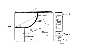
In Figure 2, the current location has been sent to
three servers: one run by a high street bank, which
returns the location of cashpoint machines, one by an
independent hotel reservation system and one by a well-
known fast food chain.
The result of the responses by the overlay servers 12
are shown in Figure 2, in which the same map is displayed
with icons 13 representing the various facilities reported
CA 02229733 1998-02-16
WO 97/07467 PCT/GB96/01996
-13 ~-
by the second server 12, and hypertext links 14 to text
pages or other Web facilities, in the usual way.
It should be noted that the client computer 10 may be
used to transmit the information request with geographical
data first. The overlay or information server 12 responds
with information data, including coordinate data, relating
to the requested services for example. This data, as well
as being used to generate the display on the client
computer lo, can be used to formulate the map request
1o including coordinate data for transmission by the client
computer 10 to the map server 11. The map server 11 then
responds with the map data, which is then transmitted to
the client computer 10. The m.ap can then be displayed on
the client computer visual display unit and overlaid with
graphics representing the information data. In other
words, either the map request or the information request
can be formulated first for transmission to the appropriate
server 11,12.
The architecture of the preferred system is such that
it can support a movable map window. A user can scroll
North, South, East or West on the screen and see more
detail appear, and can zoom in and out for more detail or
for a wider perspective using the zoom and move buttons 4.
This also enables a moving display, such as a hand-held
device or a rolling map installed in a car, to be
dynamically updated with new locations as the displayable
window moves over them.
Although the client computer 10 may be a stationary PC
connected to the Internet, the architecture is designed to
3o support mobile clients such as car navigation systems and
personal digital assistants (PDAs). The client software
preferably supports direct connection to Global Positioning
System (GPS) receivers, and preferably implements the NMEA
- 0183 standard for exchange of navigational data. If the
client is also a cellular telephone, it preferably supports
the transfer of information derived from the cellular
CA 02229733 1998-02-16
WO 97/07467 PCT/GB96/01996
-14-
network. In a preferred embodiment, the client transfers
its own position to the information server and map server
within the HTTP protocol by adding an HTTP header line to
its request messages. In the case that the client is
connected to a GPS receiver and therefore knows its exact
location, it can add an HTTP header line as follows:
remote position: lon="-0.1666"; lat="51.545". In the case
that the client does not have its exact position, but does
have access to the name of its nearest cellular base
l0 station, it can add an HTTP header line as follows:
remote_cellname: LONDON-SW-5. A map server or information
server which maintains data on the locations of cellular
base stations can convert the cell name to a location and
deliver the appropriate map and/or overlay information. In
the case that the client is not able to add HTTP header
lines as described above, location and/or cell names may be
transmitted within other HTTP headers or within the HTML
protocol, but such embodiments are not considered
preferable. It is important to note that the client will
often request information on a location other than its own
current location, and that the location of interest is
transferred within the Map Request/Information Request
URLs, while the client°s own location is transferred in the
HTTP header. This combination allows the server computers
to implement a wide range of additional functions, such as
displaying the distance from the current location to the
location of interest. In the case that the client's
location is known to be changing, such as a cellular phone
connected to a GPS receiver, the screen display may be
3o refreshed on a regular basis to show the client's current
location. This refresh may be achieved by using the
"refresh" function within the HTTP/HTML protocols, or it
may be achieved using the local programmability of the
client. -
It is particularly preferred that the additional
functionality provided within the World Wide Web, and its
CA 02229733 1998-02-16
WO 97/07467 PCT/GB96/01996
-15-
architecture, is built within the extensible framework of
HyperText Markup Language (HTDZL) and the HyperText Transfer
Protocol (HTTP). The extensions to HTML/HTTP are thus
preferably entirely compatible with existing Web standards
- 5 and do not seek to modify or replace any part of the Web
architecture.
In a preferred embodiment:, the functionality described
above is added to the client computer ZO by providing
additional software for a known Web browser (for example,
to Netscape, Mosaic, etc.). This software may be implemented
as separate programs (i.e. a '°helper application"), or as
plug-in programs that execute within a browser program, or
as Java Applets which are downloaded and executed as
required.
15 Alternatively, a subset of the full functionality may
be implemented using the browser's standard display and
positioning capabilities only. An implementation of the
latter case requires greater functionality in the
information server, and is a preferred implementation in
20 circumstances where it is difficult or impossible to add
functionality to the client browser.
The server computers 11,12 may employ well-known
standard database tools in conjunction with known Web
server packages, in order to recognise the requests and
25 generate the responses described above.
Another important feature of the present invention is
that maps and overlay information can be "persistent".
That is, pointers to maps or places can be stored in
databases on the client computer 10 and become a permanent
30 feature of displays. A typical use of this feature would
be to store the user's home location and display it on any
map covering that location.
In a preferred embodiment, persistent locations are
stored using the extensions to HTTP known as "magic
35 cookies°'. The magic cookie parameters used are based upon
the request parameters listed above, i.e.:
CA 02229733 1998-02-16
WO 97/07467 PCT/GB96/01996
-16-
Set-Cookie: Home="lon=-0.1666&lat=51.545'°;
Software may be provided for the conversion of postal
codes (zip codes) into longitude and latitude information.
Software may be provided for the conversion of full or
partial addresses into longitude and latitude information.
This software is normally provided on the map server 11; in
this case, the user enters an address or postcode in a form
and sends this to the map server. The map server responds
with an HTML document containing longitude and latitude,
and the user receives a map of the locality of the address
or postcode. Alternatively, such software can be provided
on the client computer l0.
The system and method of the present invention avoids
the classic problems of Geographic Information Systems
(GISs) by imposing a single, standardised geographic
reference model, and restricting data exchanges to those
classes of geographic information which can conform to the
reference model.
Because of this, servers providing information do not
have to deal with maps, map ownership issues or mapping
software, and information from several different sources
can be integrated on a single screen.
It is of course envisaged that the invention may be
implemented in ways which are different from the ways
specifically exemplified above. For example, the
coordinate data embodied in the map and facility
information may be presented in ways other than in absolute
latitude and longitude format.
Embodiments of the present invention have been
described with particular reference to the examples
illustrated. However, it will be appreciated that
variations and modifications may be made to the examples
described within the scope of the present invention.