Note: Descriptions are shown in the official language in which they were submitted.
CA 02232105 2004-11-23
HELICOPTER TOWED ELECTROMAGNETIC SURVEYING SYSTEM
This invention relates to an airborne electromagnetic surveying system
including a buoyant element, particularly adapted to be towed by a helicopter.
Known electromagnetic surveying systems employ transmitting means
carried by an aircraft and spaced sensor or receiving means, known as a
"bird",
towed behind the aircraft. Such a system is shown in U.S. Patent No. 4,629,990
issued December 16, 1986 to Zandee. An alternative arrangement in which
spaced transmitter and sensor elements are suspended below a helicopter is
shown in U.S. Patent No. 4,641,100, issued February 3, 1987 to Dzwinel. The
use
of a stationary dirigible as a platform for receiving signals in a seismic
system is
shown in U.S. Patent No. 4,236,234 issued November 25, 1980 to McDavid et al.
SUMMARY OF THE INVENTION
The electromagnetic survey system of this invention consists of a
transmitter assembly adapted to be towed by a helicopter, consisting of a
transmitting loop, a transmitter and a power supply; a sensor assembly
consisting
of a buoyant element carrying at least one receiving coil; a towing cable
connecting the sensor assembly behind the transmitter assembly whereby the
buoyant element dampens the motion of the transmitter assembly during towing
-1-
CA 02232105 2006-08-25
by a helicopter.
This buoyant element contributes a large part to the overall performance of
the
system allowing for a large separation, hence larger radiated power and a
stable
geometry. Previous designs have either very low radiated power, hence little
penetration,
or high power and unstable geometry.
The efficiency of a airborne electromagnetic pulsed system depends upon
several
factors and is usually directly evaluated in terms of its penetration. The
system of this
invention presents major advantages:
- Optimal radiated power
- Optimal transmitting and receiving coils separation
- Optimal geometry for most geophysical targets
In accordance with one aspect of the present invention, there is provided an
airborne electromagnetic surveying system, comprising a transmitter assembly,
adapted
to be towed by a rotary aircraft or by an airship, consisting of a tubular
transmitting loop of
single or multiple turns, a transmitter and a power supply; a receiver
assembly consisting
of a towed element or drag creating element carrying at least one receiving
coil; a towing
cable connecting the receiver assembly behind the transmitter assembly whereby
the
towed element stabilizes the motion of the transmitter assembly during towing
by the
rotary aircraft or the airship.
In accordance with another aspect of the present invention, there is provided
an
airborne surveying system, comprising a transmitter assembly, adapted to be
towed by a
rotary aircraft or by an airship, consisting of a tubular transmitting loop of
single or
multiple turns, a transmitter and a power supply; and a receiver assembly
detecting
geophysical signals resulting from eddy currents induced in ground formations
consisting
of one or more buoyant elements carrying at least one sensor element.
-2-
CA 02232105 2006-08-25
DRAWINGS
Figure 1-A shows a side view of a transmitter assembly and towed sensor
assembly;
Figure 1-B shows a plan view of the assemblies of Figures 1-A together with
alternative buoyant elements;
Figure 2-A shows a side view of a survey system using several sensor
-2a-
CA 02232105 2004-11-23
assemblies being towed by a helicopter;
Figure 2-B shows a plan view of the system of Figure 2-A;
Figure 3-A shows a a side view of an arrangement similar to Figure 1, using
a plurality of sensor assemblies but omitting a transmitter coil; and
Figure 3-B shows a plan view of the system of Figure 3-A.
DESCRIPTION OF THE PREFERRED EMBODIMENT
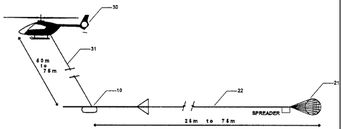
Referring to Figure 1, the electromagnetic surveying system of the invention
consists of a transmitter loop assembly 10 and a receiver assembly included in
a
drag element 21. The assemblies are towed by a helicopter 30 by means of a
towing cable 31. The transmitter loop assembly 10 is adapted to be towed 150
to
200 feet beneath the helicopter and generates a pulsed electromagnetic field
which affects conductors in the ground. The resulting effects are measured and
analyzed through sensors mounted in the receiver assembly which is included in
a drag element or buoyant vessel 21 towed behind the transmitter loop
assembly.
It is connected to the helicopter by a signal carrying cable 22.
Alternatively, the
signals from the receiver, known as response signals can be transmitted to the
helicopter by a radio or optical link as shown in Figure 1-B. The buoyant
vessel
can take the form of a parachute (21 a), blimp (21 b) or balloon (21 c).
The transmitting loop 11 is a ring of large diameter (over 30 feet or 10
-3-
CA 02232105 2004-11-23
meters) normally flown horizontally. The loop is made of a single aluminum
tube,
in a preferred embodiment having a diameter of approximately 3.5" and a wall
thickness of 0.1" requiring little supporting structure. The dimensions of the
tube
determine the performance (maximum or peak magnetic moment measured in
NIA) of the transmitter assembly. If required by the electrical specifications
of the
transmitter, the loop can also be made of several tubes of lesser diameter
arranged to form an annular bundle. These configurations offer several
advantages:
- Rigid self supporting assembly (No need for supporting heavy structure)
- Large area;
- Small electrical resistance, heavy current, maximum moment.
Absent restrictions concerning the power source, it can be demonstrated
that the moment that can be generated with a certain weight of conducting
material is at a maximum when this material is arranged to form one single
turn
(continuous current) and is only a function of flat weight. The dimensions of
the
ring (radius, tube diameter and thickness) can be varied to match a particular
generator or to transmit a particular waveform.
The transmitter assembly 10 is enclosed in a ellipsoidal or cylindrical vessel
to which the transmitting loop is rigidly fixed. It comprises a set of high
capacity
-4-
CA 02232105 2004-11-23
batteries, a decoupling capacitor array, a transmitter pulse-forming assembly
and
a bank of tuning capacitors. It generates current pulses that are circulated
through
the loop.
This configuration offers several advantages:
- Totally autonomous transmitting system (no power connection with the
helicopter
electrical system);
- The batteries can be selected for the appiication: endurance, internal
resistance,
weight. The energy density of sulfur-sodium cells being three to four times
greater
than that of equivalent NiCad cells, such batteries can allow for powerful
autonomous systems (One million NIA or more with an endurance of over three
hours).
In the preferred embodiment, the transmitter assembly contains two Ni-Cad
batteries feeding separate pulse switches, turned on in an alternating
sequence
and capable of switching several thousand amperes.
The weight of the transmitter assembly and the loop depends upon the
selected maximum moment and the size of the towing helicopter. It can vary
from
200 to 1000 pounds or more. For a small commercial helicopter the optimal
-5-
CA 02232105 2004-11-23
weight is approximately 600 lbs.
The transmitter can also be powered, in part or totally, by current tapped
from the power source of the towing aircraft or an integrated alternator-motor
assembly. Batteries and power source tapping can be combined to extend the
endurance of the system, or to increase the current, the repetition rate or
the width
of the pulses.
The receiver assembly consists of a buoyant vessel 21 connected to the
transmitter assembly 10 by a towing cable 22. This vessel contains the sensors
which detect the secondary field. The sensors can be ferrite core coils or
large air
coils, mounted along three axes (horizontal (x), vertical (v) and transversal
(z).
The vessel contains the associated electronic circuits: amplifiers, clock, DSP
(digital signal processing), digital flux feedback circuits and optical modem.
The
modem transmits the data at very high rate to the processor mounted in the
cabin
of the helicopter. It also send triggering signals to the transmitter.
The buoyant vessel 21 is towed from the rear apex of the transmitting loop,
at a distance selected to suit the application. It has a small negative
buoyancy
(vertical down force) and a fairly high drag (longitudinal force opposing
direction
of flight). The high drag serves several purposes: it maintains sufficient
tension
on the tow cable to stabilize the transmitting loop and the transmitter, it
forms a
-6-
CA 02232105 2004-11-23
natural damper which eliminates longitudinal and vertical jerky movements or
accelerations and it gives the overall system (transmitter and receiver
assemblies)
a stable geometry with good separation.
The buoyant vessel 21 can be a ellipsoidal blimp (21b in Figure 1-B)
inflated with helium. The blimp has a standard form and can be stabilized by
fins
or a parachute. The invention can also use a spherical balloon (21 C in Figure
1-B)
towed in a supporting net forming an inverted cone or a specially designed
parachute (21a in Figure 1-A) attached to the receiving sensors assembly as
indicated in Figure 1-B. The tow cable 22 is attached to the nose of the
blimp.
The receiver assembly is mounted in a specially designed chamber situated in
the
bottom part of the blimp. This keeps the whole assembly stable and prevents it
from rolling and twisting around the tow axis.
Figures 2A and 2B show an embodiment in which several detectors are
used simultaneously in buoyant vessels 21 a, 21 b and 21 c with lateral or
vertical
spacing using a spreader as known for use in sonar or seismic arrays and shown
in Figure 3-B.
A downrigger technique can be used with any vessel causing drag such as
a blimp or zeppelin using a dead weight 41 (ball or heavy object) suspended
underneath the helicopter as tow point as shown in Figures 3-A and 3-B. This
-7-
CA 02232105 2004-11-23
downrigger can be used for other applications such as magnetometery or
gravimetry not requiring a transmitter element. Drag inducing vessels of other
shapes such as blimp, zeppelin, drag-chute or windsock configuration can be
used.
The towed downrigger configuration can be used to tow several laterally or
vertically spaced buoyant elements 21a, 21b and 21c as shown in Figure 3-B,
containing detectors, using a spreader 42, as used in sonar or seismic arrays.
The spreaders 42 are designed to steer the buoyant vessels 21 away from the
axis of towing cable 22 until they stabilize themselves on lines left or
right, below
or above the flight path. Spatial separation (vertical, lateral and
longitudinal) can
be obtain by varying the ballast or volume, the length of the tow ropes 23 or
the
angle of attack of the spreaders.
This arrangement provides improved resolution and a substantial saving in
flight time, since the system can cover two or three lines in one path and
measure
transversal, longitudinal or vertical gradients. It can be used with different
type of
sensors such as: magnetometers, VLF sensors, laser altimeters, remote sensing
devices including spectrometers and sniffers.
-8-