Language selection

Search

Patent 2233940 Summary

Third-party information liability

Some of the information on this Web page has been provided by external sources. The Government of Canada is not responsible for the accuracy, reliability or currency of the information supplied by external sources. Users wishing to rely upon this information should consult directly with the source of the information. Content provided by external sources is not subject to official languages, privacy and accessibility requirements.

Claims and Abstract availability

Any discrepancies in the text and image of the Claims and Abstract are due to differing posting times. Text of the Claims and Abstract are posted:

  • At the time the application is open to public inspection;
  • At the time of issue of the patent (grant).
(12) Patent: (11) CA 2233940
(54) English Title: GRITTING SYSTEMS AND METHODS
(54) French Title: SYSTEMES DE SABLAGE ET PROCEDES ASSOCIES
Status: Deemed expired
Bibliographic Data
(51) International Patent Classification (IPC):
  • E01H 10/00 (2006.01)
  • E01C 19/00 (2006.01)
(72) Inventors :
  • WILLIAMS, BRIAN (United Kingdom)
(73) Owners :
  • WILLIAMS, BRIAN (United Kingdom)
(71) Applicants :
  • NEATH PORT TALBOT COUNTY BOROUGH COUNCIL (United Kingdom)
  • CITY AND COUNTY OF SWANSEA (United Kingdom)
(74) Agent: RIDOUT & MAYBEE LLP
(74) Associate agent:
(45) Issued: 2004-07-06
(86) PCT Filing Date: 1996-10-07
(87) Open to Public Inspection: 1997-04-17
Examination requested: 1998-04-03
Availability of licence: N/A
(25) Language of filing: English

Patent Cooperation Treaty (PCT): Yes
(86) PCT Filing Number: PCT/GB1996/002454
(87) International Publication Number: WO1997/013926
(85) National Entry: 1998-04-03

(30) Application Priority Data:
Application No. Country/Territory Date
9520478.0 United Kingdom 1995-10-06

Abstracts

English Abstract


Methods and systems for controlled gritting of routes, e.g. roads, are
disclosed. A gritting vehicle (3) has a continuously-operating
position detection arrangement e.g. GPS and has an on-board information
processor (MDT) in which route data such as forecast thermal
map data are stored. The stored data can be transmitted to the vehicle (3)
from a control station processor via a radio link. Real-time
positional data are compared with the route data in the vehicle's processor
and generate gritting instructions to control whether and how
much grit is deposited at a given location. Positional and gritting status
information may be transmitted back to the control station (1)
progressively for recording. On-board sensors (S) may be used to supplement
forecast data.


French Abstract

On décrit des procédés et systèmes destinés au sablage commandé de voies matérialisées, par exemple de routes. Un véhicule (3) de sablage présente un dispositif de détection de position fonctionnant en continu, par exemple un système de positionnement global (GPS), ainsi qu'un processeur d'informations embarqué (terminal de données mobile), dans lequel sont stockées des données d'itinéraire, telles que des données cartographiques thermiques prévisionnelles. Les données stockées peuvent être transmises au véhicule (3) à partir d'un processeur de la station de commande, via une liaison radio. Des données de position en temps réel sont comparées avec les données, concernant les voies matérialisées, du processeur du véhicule et produisent des instructions de sablage à l'intention de l'organe de commande, déterminant quand il faut sabler et quelle quantité de sable il faut répandre au niveau d'un endroit donné. Des informations d'état relatives à la position du véhicule et au sablage peuvent être transmises en retour à la station (1) de commande, aux fins d'enregistrement progressif de ces données. On peut utiliser des capteurs (S) embarqués pour compléter les données prévisionnelles.

Claims

Note: Claims are shown in the official language in which they were submitted.


CLAIMS

1. A gritting method in which a vehicle including
gritting apparatus travels along a road and disperses grit,
or other material adapted to prevent or reduce ice
formation, on the road in accordance with a gritting
routine, the method comprising steps of
progressively determining and monitoring the location
of the vehicle along the road using a positioning system to
generate monitored position data substantially continuously
or regularly;
comparing, using an information processor, the
monitored position data with stored road information
comprising data indicative of varying location-dependent
gritting requirements for the road;
generating a gritting instruction in dependence on the
comparison, to control one or more adjustable parameters of
the grit dispersion in a manner appropriate to the gritting
requirements at the vehicle's position, wherein the
information processor is on the vehcile and the road
information is transmitted to the vehicle's information
processor for storage therein from a control station remote
from the vehicle.

2. A method according to claim 1 comprising determining
the location of the vehicle using a global positioning
system (GPS) whereby the vehicle receives and processes
data transmitted from a global satellite.

3. A method according to claim 2 in which the GPS is a
differential global positioning system (DGPS)which corrects

17


the determined position by comparing the satellite data
received at the vehicle with corresponding satellite data
received at one or more stationary receivers at known
locations.

4. A method according to any one of claims 1 to 3, in
which the stored road information comprises a thermal map
indicating temperatures at least along the road.

5. A method according to claim 4, in which the thermal
map is a forecast thermal map and the temperatures are
predicted temperatures.

6. A method according to any one of claims 1 to 5, in
which grit dispersion data, indicating the status or status
of one or more of said grit dispersion parameters are
progressively stored in conjunction with the corresponding
position data, as the vehicle travels.

7. A method according to claim 6, in which said grit
dispersion data are transmitted from the vehicle to, and
stored at, a control station remote from the vehicle.

8. A method according to any one of claims 1 to 7, in
which the position data are progressively transmitted from
the vehicle to a control station remote from the vehicle
and the vehicle's progress is tracked at the control
station.

9. A method according to any one of claims 1 to 8,
comprising monitoring conditions along the road using a
sensor on the vehicle, and sending the resulting road
condition data to the information processor.

18


10. A method according to claim 9, in which the gritting
instructions can be adjusted in dependence on said road
condition data.

11. A method according to claim 9 or claim 10, in which
the detection of discrepancies between the road condition
data and corresponding data from the stored road
information triggers a revision of the stored road
information.

12. A method according to any one of claims 1 to 11, in
which the information processor selects a road to be taken
by the vehicle and signals a corresponding road
instruction.

13. A method according to any one of claims 1 to 12, in
which a said adjustable parameter is a choice between
dispersing and not dispersing material.

14. A method according to any one of claims 1 to 13, in
which a said adjustable parameter is a variable spreading
density of material.

15. A method according to any one of claims 1 to 14, in
which the gritting instruction is transmitted to a control
system of the gritting apparatus to adjust said dispersion
parameter(s) automatically.

15. A method according to any one of claims 1 to 15, in
which the gritting instruction is transmitted to means for
signalling to an operator of the vehicle.

19


17. A gritting control arrangement comprising
(a) a positioning system for determining and
monitoring the location of a gritting vehicle on a road, to
provide corresponding position data;
(b) an information processing arrangement on the
vehicle, adapted to receive said position data and
comprising
a road information store for data indicative of a
variable location-dependent gritting requirements along the
road;
means for comparing current said position data with
the stored road information and determining one or more
corresponding grit dispersion parameters appropriate for a
current location of the gritting vehicle,
means for generating a gritting instruction for
controlling gritting apparatus in accordance with said one
or more dispersion parameters,
wherein the road information is transmitted to the
vehicle's information processing arrangement for storage
therein from a control station remote from the vehicle.

18. A gritting control arrangement according to claim 17,
in which the information processing arrangement includes an
on-board information processor for the vehicle and a
control processor for said control station remote from the
vehicle, and the gritting control arrangement includes
communication means such as a radio for data to pass
between said processors.

20


19. A gritting method in which a vehicle including
gritting apparatus travels along a road and disperses grit,
or other material adapted to prevent or reduce ice
formation, on the road in accordance with a gritting
routine, the method comprising steps of
progressively determining and monitoring the location
of the vehicle along the road using a positioning system to
generate monitored position data substantially continuously
or regularly;
comparing, using an information processor, the
monitored position data with stored road information
comprising data indicative of varying location-dependent
gritting requirements for the road, in which the stored
road information comprises a thermal map indicating
temperatures at least along the road; and
generating a gritting instruction in dependence on the
comparison, to control one or more adjustable parameters of
the grit dispersion in a manner appropriate to the gritting
requirements at the vehicle's position.

20. A method according to claim 19, comprising determining
the location of the vehicle using a global positioning
system (GPS) whereby the vehicle receives and processes
data transmitted from a global satellite.

21. A method according to claim 20, in which the GPS is a
differential global positioning system (DGPS)which corrects
the determined position by comparing the satellite data
received at the vehicle with corresponding satellite data

21


received at one or more stationary receivers at known
locations.

22. A method according to any one of claims 19 to 21, in
which the information processor is on the vehicle.

23. A method according to claim 22, in which the road
information is transmitted to the vehicle's information
processor for storage therein from a control station remote
from the vehicle.

24. A method according to claim 19, in which the thermal
map is a forecast thermal map and the temperatures are
predicted temperatures.

25. A method according to any one of claims 19 to 24, in
which grit dispersion data, indicating the status or status
of one or more of said grit dispersion parameters are
progressively stored in conjunction with the corresponding
position data, as the vehicle travels.

26. A method according to claim 25, in which said grit
dispersion data are transmitted from the vehicle to, and
stored at, a control station remote from the vehicle.

27. A method according to any one of claims 19 to 26, in
which the position data are progressively transmitted from
the vehicle to a control station remote from the vehicle
and the vehicle's progress is tracked at the control
station.

28. A method according to any one of claims 19 to 27,
comprising monitoring conditions along the road using a

22


sensor on the vehicle, and sending the resulting road
condition data to the information processor.

29. A method according to claim 28, in which the gritting
instructions can be adjusted in dependence on said road
condition data.

30. A method according to claim 28 or claim 29, in which
the detection of discrepancies between the road condition
data and corresponding data from the stared road
information triggers a revision of the stored road
information.

31. A method according to any one of claims 19 to 30, in
which the information processor selects a road to be taken
by the vehicle and signals a corresponding road
instruction.

32. A method according to any one of claims 19 to 31, in
which a said adjustable parameter is a choice between
dispersing and not dispersing material.

33. A method according to any one of claims 19 to 32, in
which a said adjustable parameter is a variable spreading
density of material.

34. A method according to any one of claims 19 to 33, in
which the gritting instruction is transmitted to a control
system of the gritting apparatus to adjust said dispersion
parameter(s) automatically.

35. A method according to any one of claims 19 to 34, in
which the gritting instruction is transmitted to means for
signalling to an operator of the vehicle.

23


36. A gritting control arrangement comprising
(a) a positioning system for determining and
monitoring the location of a gritting vehicle on a road, to
provide corresponding position data;
(b) an information processing arrangement adapted to
receive said position data and comprising
a road information store for data indicative of
variable location-dependent gritting requirements along the
road, said data indicative of variable gritting
requirements comprising a thermal map indicating
temperatures at least along the road,
means for comparing current said position data with
the stored route information and determining one or more
corresponding grit dispersion parameters appropriate for a
current location of the gritting vehicle, and
means for generating a gritting instruction for
controlling gritting apparatus in accordance with said one
or more dispersion parameters.

37. A gritting control arrangement according to claim 36,
in which the information processing arrangement includes an
on-board information processor for the vehicle and a
control processor for a control station remote from the
vehicle, and the gritting control arrangement includes
communication means such as a radio for data to pass
between said processors.

38. A gritting method in which a vehicle including
gritting apparatus travels along a road and disperses grit,

24


or other material adapted to prevent or reduce ice
formation, on the road in accordance with a gritting
routine, the method comprising steps of
progressively determining and monitoring the location
of the vehicle along the road using a positioning system to
generate monitored position data substantially continuously
or regularly;
monitoring conditions along the road using a sensor on
the vehicle;
comparing, using an information processor, the
monitored position data and road condition data with stored
road information comprising data indicative of varying
location-dependent gritting requirements for the road;
generating a gritting instruction in dependence on the
comparison, to control one or more adjustable parameters of
the grit dispersion in a manner appropriate to the gritting
requirements at the vehicle's position.

39. A method according to claim 38, comprising determining
the location of the vehicle using a global positioning
system (GPS) whereby the vehicle receives and processes
data transmitted from a global satellite.

40. A method according to claim 39, in which the GPS is a
differential global positioning system (DGPS)which corrects
the determined position by comparing the satellite data
received at the vehicle with corresponding satellite data
received at one or more stationary receivers at known
locations.

25


41. A method according to any one of claim 38 to 40, in
which the information processor is on the vehicle.

42. A method according to claim 41, in which the road
information is transmitted to the vehicle's information
processor for storage therein from a control station remote
from the vehicle.

43. a method according to any one of claims 38 to 42, in
which the stored road information comprises a thermal map
indicating temperatures at least along the road.

44. A method according to claim 43, in which the thermal
map is a forecast thermal map and the temperatures are
predicted temperatures.

45. A method according to any one of claims 38 to 44, in
which grit dispersion data, indicating the status or
statuses of one or more of said grit dispersion parameters
are progressively stored in conjunction with the
corresponding position data, as the vehicle travels.

46. A method according to claim 45, in which said grit
dispersion data are transmitted from the vehicle to, and
stored at, a control station remote from the vehicle.

47. A method according to any one of claims 38 to 46, in
which the position data are progressively transmitted from
the vehicle to a control station remote from the vehicle
and the vehicle's progress is tracked at the control
station.

26


48. A method according to claim 38, in which the gritting
instructions can be adjusted in dependence on said road
condition data.

49. A method according to claim 48, in which the detection
of discrepancies between the road condition data and
corresponding data from the stored road information
triggers a revision of the stored road information.

50. A method according to any one of claims 38 to 49, in
which the information processor selects a road to be taken
by the vehicle and signals a corresponding road
instruction.

51. A method according to any one of claims 38 to 50, in
which a said adjustable parameter is a choice between
dispersing and not dispersing material.

52. A method according to any one of claims 38 to 51, in
which a said adjustable parameter is a variable spreading
density of material.

53. A method according to any one of claims 38 to 52, in
which the gritting instruction is transmitted to a control
system of the gritting apparatus to adjust said dispersion
parameters) automatically.

54. A method according to any one of claims 38 to 53, in
which the gritting instruction is transmitted to means for
signalling to an operator of the vehicle.

27


55. A gritting control arrangement comprising
(a) a positioning system for determining and
monitoring the location of a gritting vehicle on a road, to
provide corresponding position data;
(b) a sensor system for monitoring conditions along
the road to provide road condition data; and
(c) an information processing arrangement adapted to
receive said position data and road condition data and
comprising

a road information store for data indicative of
variable location-dependent gritting requirements along the
road;

means for comparing current said position data with
the stored road information and determining one or more
corresponding grit dispersion parameters appropriate for a
current location of the gritting vehicle, and
means for generating a gritting instruction for
controlling gritting apparatus in accordance with said one
or more dispersion parameters.

56. A gritting control arrangement according to claim 55,
in which the information processing arrangement includes an
on-board information processor for the vehicle and a
control station remote from the vehicle, and the gritting
control arrangement includes communication means such as a
radio for data to pass between said processors.

28

Description

Note: Descriptions are shown in the official language in which they were submitted.


CA 02233940 1998-04-03
WO 97/13926 PCT/GB96/02454
' GRITTING SYSTEMS AND METHODS - --
FIELD OF THE INVENTION
The present invention relates to methods, apparatus
and control systems for dispensing salt, grit or other
substances on surfaces, for=example for spreading salt or
grit over icy roads.
BACKGROUND
Measures are conventionally taken in a wide range of
weather conditior~s for ensuring that highways, major
urban roads and even more minor routes are kept open for
traffic. In cold countries, or during wintery periods
in more temperate climates, salt, grit or other
substances are dispensed onto road surfaces to ameliorate
driving conditions, for example by preventing or reducing
build up of ice. Hereinafter the salt, grit or other
substances, whether or not particulate, will be referred
to simply as "grit", while~the process by which they are
applied will be termed "gritting".
Gritting is conventionally performed by gritting
vehicles which carry a store of grit and travel along a
predetermined route distributing grit across the road
surface as they travel. Grit is dispensed at a
substantially constant rate, although in special
circumstances the driver may increase the rate_
Producing and supplying large quantities of grit is
' expensive. Furthermore, besides the beneficial effects
of gritting there are also important detrimental effects.
1

CA 02233940 1998-04-03
WO 97/13926 PCT/GS96/02454
Some grits cause significant environmental damage, or- --
are corrosive to vehicles_ For these reasons it is
desirable that the amount of grit dispensed is minimised,
while ensuring that roads are effectively treated. '
Development in the technology is slow, since
gritting is a vital safety service and no modification
can be tolerated if it may reduce effectiveness.
Nevertheless, techniques have recently been devised to
help determine more accurately when it is necessary to
carry out gritting. One such technology mattes a
"thermal map" of a geographical area by surveying the
area to determine a map of the local temperature
variations, due e.g. to exposure to cold winds. In
particular a relevant kind of thermal map indicates which
parts of major roads are prone to low temperatures. This
fixed information can be combined with periodically or
continuously updated information from local weather
stations concerning actual weather in specific locations,
to produce a "forecast thermal map" which approximates a
predicted actual temperature distribution in a region.
Graphical information can then be generated showing
estimated temperature variation along each of the
predetermined potential gritting routes, and hence
showing which of such routes include stretches of road
which are liable to become icy. If the entire length of
a route should be free from ice, no gritting vehicle need
pass along it. If it is found that a given route
includes a potentially icy stretch of road then a vehicle
2

CA 02233940 1998-04-03
WO 97/13926 PCT/GB96/02454
is sent. - --
DE-A-3938147 describes a gritting system which seeks
to reduce the mentioned difficulties by pre-determining a
~ gritting rate profile based on knowledge of the route's
temperature variation characteristics and the prevailing
weather conditions; the profile is loaded into an on-
board computer and used to operate a control mechanism
for the gritting apparatus, controlling spreading
density, width and lateral distribution profile. Change
from one made oL spreading tc~ another is actuated by
occasional reflector plates positioned adjacent the
route, which reflect radiation beams back to the vehicle.
In its broadest terms, the present invention
proposes a gritting system in which the position of at
least one gritting vehicle (preferably plural gritting
vehicles) is monitored, preferably at an external control
or tracking station and preferably substantially
continuously or regularly.
In a first aspect we provide a method of gritting in
which the location of at least one gritting vehicle is
monitored and the dispersement of grit is controlled in
dependence on a predetermined gritting requirement at
that location. In this way, the efficiency of the
gritting may be enhanced.
The control is preferably exercised in dependence
upon a predicted temperature at the location of the
gritting vehicle, e.g. the predicted temperature of that
location according to a forecast thermal map.
3

CA 02233940 1998-04-03
WO 97/13926 PCT/GB96/02454
As a first example, grit may be dispensed only along --
portions of the route including stretches which the
forecast thermal map has estimated to be at or below zero
degrees Celsius_ The gritted portions may in fact '
substantially correspond to the sub-zero stretches of the
route, but, more preferably, they include also adjacent
stretches of the road so as to produce a safety margin.
As a second example, the control may not merely
determine whether or not grit is dispensed along a given
stretch of road hut, more preferably, additionally (or
indeed alternatively) the rate at which grit is
dispensed. Thus, grit may be applied at a greater rate
to those regions which are predicted to be at a lower
temperature. Such control of the rate at which grit is
dispensed optionally depends also upon the velocity of
the gritting vehicle, for example so that the density of
grit application (ie. rate of release of grit/velocity of
the gritting vehicle) obeys a predetermined relationship
with the predicted temperature.
The control of grit dispersion may in either case be
automated, i.e. control means may be provided which
controls the rate of gritting automatically in dependence
on the predetermined local gritting requirement. Or,
control may be via a human operator. For example the
mechanism may calculate automatically whether or not, or
to what extent, gritting should occur, and transmit a
corresponding instruction to the driver of the gritting '
vehicle (eg. by indication lights or voice synthesis).
4

CA 02233940 1998-04-03
WO 97/13926 PCT/GB96/02454
- The driver then controls the rate of gritting - w
accordingly. Preferably, even in the most automated
embodiments, the operator is able to at least influence
the gritting, albeit as a manual override of an automatic
mechanism, to exploit his or her personal knowledge, for
example a knowledge of small local frost hollows or the
presence of water on the road due to a burst pipe.
Preferably, a gritting vehicle carries one or more
sensors for measuring at least one local weather or
surface condition, for example surface temperature or
residual salinity. Control of gritting may then be
carried out also in dependence on the results of the
measurement. For example, it is possible to monitor in
real time any discrepancy between the predicted
temperature in the vicinity of the gritting vehicle and
the actual temperature. This permits updating and/or
correction of the forecast thermal map. Thus, feedback
is possible in which the gritting is controlled in real
time in dependence upon measurements derived by the
gritting vehicle_ Another possibility is that the
gritting rate is controlled in substantial or full
dependence on such real-time measurements from one or
more on-board sensors_ In such cases a forecast thermal
map may be used only for e.g. route selection (see below)
and/or as a back-up indicator of the amount of grit
required.
' The control of gritting need not only be a control
of the rate of gritting, but may additionally or
5

CA 02233940 1998-04-03
WO 97/13926 PCT/GB96/02454
- alternatively include a control of the route taken by a w
gritting vehicle. Accordingly, in a second aspect the
invention provides a method of gritting in which the
location of at least one gritting vehicle is monitored
and the route of the at least one gritting vehicle is
controlled in dependence on the measured location of the
vehicle_
As a first example, the route of a gritting vehicle
need not be predetermined but may be selected on the
basis of a forecast thermal map, for example so as to
cover efficiently all especially cold roads. In this
case, the monitored position of the gritting vehicle can
be used to generate directional instructions to the
driver.
A second example is when, as described above, a
comparison of the information derived from one or more
weather sensors mounted on the vehicle with the data from
the corresponding location on the forecast thermal map
indicates that weather has deteriorated_ In this case, an
update of the forecast thermal map may demonstrate that
additional grit should be applied to a given stretch of
road_ Accordingly the gritting system may assign a
gritting vehicle to perform the additional gritting of
the road. The assignment preferably takes into account
the location of the gritting vehicles, and/or the amount
of grit each is carrying.
In a third aspect, the invention may provide a
method of gritting in which the location of at least one
6

CA 02233940 1998-04-03
W~ 97/13926 PCT/GB96/02454
gritting vehicle is monitored and the location -
information is collected in real time off the gritting
vehicle or vehicles, for example after transmission to a
central database. Thus, reliable and secure archiving
may be performed, for example to establish whether or not
gritting was performed correctly.
A desirable feature of a gritting system would be an
accurate recordal or "archiving~~ of the manner in which
gritting is carried out. This record can be valuable in
the event of an accident, in determining whether gritting
was adequate and apportioning liability. Accurate and
secure records are becoming increasingly important
because of the legal duty of ensuring that gritting is
done correctly. At present no system of archiving is
more sophisticated than a simple measurement and recordal
of the weight of a gritting vehicle at the beginning and
the end of a gritting session, from which only the
average rate of gritting can be recorded.
In each aspect the monitoring of location is
preferably by a Global Positioning System (GPS), that is
a system in which an object is located by reception at
that object of data transmitted by a global satellite.
The use of such equipment is well known for locating
ships and other vehicles, but has not been associated
with gritting. Conventional GPS has an accuracy of only
about 50-100m. To determine which road the gritting
vehicle is on even in an urban environment, the present
invention preferably uses a variety of GPS known as a
7

CA 02233940 1998-04-03
WO 97/13926 PCTlGB96/02454
"Differential Global Positioning System" (DGPS), which --
increases the accuracy of the position determination to
within a few metres. DGPS reduces noise in the signal
received from a satellite by comparing the signal
received from an antenna mounted on the gritting vehicle ,
with a corresponding signal received by one or more
stationary receivers in known locations, so that the
location of the gritting vehicle can be derived from the
difference between the two sets of signals. DGPS is a
known technology per se.
Embodiments of the present invention are now
described with reference to the accompanying figures, in
which:
Fig 1 is a schematic view of a gritting system;
Fig 2 shows one possible appearance of a forecast
thermal map;
Fig 3 shows schematically a small part of such a
map, and
Fig 4 shows the same part with actual gritting data
recorded_
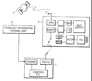
Fig 1 shows a gritting arrangement schematically. A
gritting lorry 3, which may be one of plural lorries
(e. g. 10 or more) under common control, carries a grit
supply and a dispersing or dispensing arrangement DA for
applying grit to the road. A conventional dispensing
arrangement such as a spinning spreader disc may be used.
It operates under the control of a dispensing control
mechanism DCON. This can act on the dispensing
8

CA 02233940 1998-04-03
WO 97/I3926 PCT/GB96/02454
arrangement to adjust one or more dispersion parameters --
e.g. spreading/not spreading, spread width, spreading
rate (weight grit/unit area).
The vehicle's position is monitored on a
substantially continuous basis by a position monitor,
here a global positioning system GPS. This is adapted to
receive data for position determination from one or more
satellites 4. These systems are well known as such, and
their installation and implementation in a vehicle does
not present any special problems. We prefer DGPS, as
mentioned above.
The GPS unit is connected to an on-board data
processor or mobile data terminal MDT. This works with a
data store in which gritting-related route information
such as forecast thermal map data is stored. The
processor MDT is connected to receive position data from
the GPS unit and programmed to compare or relate this
with the corresponding coordinates in the stored route
information to derive gritting parameters) appropriate
for the presumed local route conditions. The gritting
parameters) may be transmitted to the dispensing control
DCON and/or to a signalling display SIG for
implementation via a manual control MAN.
The vehicle carries a RADIO transceiver for radio
link communication with a corresponding transceiver at a
fixed control centre 1 from which the vehicles) 3 is/are
controlled and monitored. Route data, e.g. forecast
thermal map data, can be sent through the radio link for
9

CA 02233940 1998-04-03
W~ 97/13926 PCT/GB96/02454
storage in the vehicle's MDT. The CONTROL PC may obtain
the data from a commercial forecast data supplier or
contractor, edited into a suitable format and e.g.
downloaded from the supplier's own database 2.
Various kinds of thermal map data may be used. One
type has been described above. Another useful type may
be prepared by predicting route surface temperatures over
a contoured grid system, using survey information on
altitude, local thermal patterns or fingerprints and wind
characteristics (speed, direction, shelter?. Such a map
gives good results for temperatures near to freezing.
Fig 2 shows a predetermined route of a gritting
vehicle which begins at a point A and proceeds via points
B, C, D and E to a destination F. In some portions of
the route, the gritting vehicle must cover the same
stretch of road twice. For example, after the gritting
vehicle has covered the stretch from D to E, it must
retrace its path from E to D before recommencing its
journey to D to F.
The forecast thermal map illustrates the predicted
temperature along the route of the gritting vehicle. For
example, between points A and B the temperature is well
above zero; between points B and C the temperature is
close to zero; between points C and D the temperature is
below zero; and between points D and E the temperature is
well below zero. The map would typically show the
different temperature zones using different colours on a
display screen at the control centre.

CA 02233940 1998-04-03
WO 97/13926 PCT/GB96/02454
In one procedure the gritting vehicle only applies --
grit in regions of the route which, according to the
forecast thermal map, are close to zero temperature or
colder, i.e_ the gritting vehicle starts to apply grit at
point B, or shortly before to provide a safety margin.
Within these regions of the route, the gritting vehicle
travels at a substantially constant speed and dispenses
grit from the vehicle at a constant rate.
In a second procedure the gritting operation is
controlled so that grit is dispensed at a faster rate in
the colder parts of the road, for example at a higher
rate between points D and E than between points C and D.
Thus in either procedure the grit is applied only in
those regions in which it is required, while in the
second procedure its density on the road is distributed
more efficiently with respect to the temperature
distribution of the road.
The required gritting control information may all be
loaded into the gritting vehicle before it sets off on
its journey, or it may be updated continually or
periodically during travel by radio.
~1s described above, a software application in the
MDT determines when the gritting operation should be
started and stopped as the vehicle follows its
predetermined route. If the gritting vehicle includes
one or more sensors S then the MDT has an interface with
this/these too.
The gritting operation may be automated e.g. using
11

CA 02233940 1998-04-03
WO 97/13926 PCT/GB96/02454
known control technology, or the driver may retain some -'
or total control of the gritting operation, receiving
from the MDT at an audible and/or visible display
instructions as to where to start or stop gritting or
adjust the spread rate. For example indication lights
and/or a speech synthesiser may be fitted in the vehicle
cab.
The MDT monitors the location and activity of the
vehicle and the corresponding data are sent via the
:LO digital 1~ADI0 network to the central control 1, either on
demand or automatically at regular intervals.
The control centre 1 contains a control system
referred to here as a Geographical Information System
(GIS). It may consist of a PC connected to a local area
network and packet radio modem to support the
communications service.
The software of the fixed control system (GIS) may
provide any or all of the following functions:
1. Route determination: e.g those routes which are
predicted to have a minimum road surface temperature at
or below 0'C (and consequently to require treatment) are
identified in colour on a graphical display depicting all
routes. Those routes not requiring treatment default to
a neutral colour_ At this stage the duty officer may
accept or modify the routes selected. The system then
issues the appropriate instructions to the depot which
prepares the gritting vehicles for their respective
journeys, via a modem or fax.
12

CA 02233940 1998-04-03
WO 97/13926 PCT/GB96/02454
-. 2. Position and Status of ZTehicle(s): e.g. the duty - -'
officer can observe the positional co-ordinates of the
data together with each current status. Typical status
parameters are:
whether the gritting is on or off;
the gritting rate of spread (eg. lOg/ma, 30g/m2 or
40g/mz) ;
the number of lanes of the road over which the gritting
vehicle is spreading grit;
which lane on the road the vehicle occupies;
whether the vehicle is ploughing;
the weight of material in the gritting vehicle's hopper
(note the possible weight sensor WT);
whether the spinner of the gritting vehicle is
symmetrical ( indicating how the grit is being
distributed);
the distance to a point at which the gritting operation
should be altered;
the speed of the vehicle, and
any detected system failure._
Software routines enable a display of the position
and status of the gritting vehicle in real time on
graphical visual display. The position and status of a
gritting vehicle is represented by a marker ~~blip"
superimposed over a (e.g.detailed ordnance survey) map
background. The appearance e.g. colour and/or shape of
each marker is determined according to the status of the
vehicle. The same software cari be used to analyse the
13

CA 02233940 1998-04-03
WO 97/13926 PCT/GB96/02454
- records made of the activity of the gritting vehicle.
The activity logs are stored in the system and can be
maintained, enabling a complete record of gritting
activity at a given time.
Figs 3 and 4 illustrate such a presentation. Fig 3
shows the original forecast thermal map data as viewable
at the control centre. Sections A of a main route are
predicted to be in the range -1 to +1C, sections B in the
range -3 to -1C. Another route C is deemed not worth
gritting or is part of another route so no data are
given. Fig 3 shows the result, stored and viewable at
the control center, after gritting. Each blob on the
route represents a data packet sent at uniform short
intervals, e.g. 15 s. The appearance of each blob
indicates gritting density; solid is 20 and open a.s 10 g
per sq. metre. Fig 4 also indicates a concurrently-
produced tabular record including for each packet (each
row of the table) further information about the vehicle
and gritting status (e_g. items as suggested above).
The activity log may form the basis of a management
audit trial, for example to produce reports on the
performance of contractors carrying out winter
maintenance operations. It may also be used to derive
and record the cost of gritting in overall terms and/or
at the level of an individual vehicle. The data may also
be used to ensure that an adequate supply of grit is
maintained. In addition, the GIS may have the capability
to analyse a forecast thermal map and combine sub-zero
14

CA 02233940 1998-04-03
WO 97!13926 PCT/GB96/02454
sections of more than one route (possibly taking into
account information concerning response and treatment
times, network impedance, gritting vehicle capacity and
proximity to the depot) to design a new route that has
the shortest distance between sections to be gritted,
r
thus creating a unique route or set of routes, for
example on a nightly basis. If, for example, two or
three routes require a partial treatment, the GIS may
create a single route out of the lengths to be treated,
and the GPS may then trigger navigational instructions to
the driver. In this way, it is possible for one vehicle
to do the work of two or more with resulting savings in
manpower, equipment and environmental damage.
In situations where weather conditions deteriorate
resulting in a revision of a forecast thermal map it may
be necessary to change the instructions to the gritting
vehicle in real time. This can be achieved by an
interactive combination of GPS and GIS. As information
concerning the position and status of a gritting vehicle
is sent back to the central control system, the GIS
calculates the nearest vehicle with sufficient grit on
board (sensors on the gritting vehicle may monitor the
grit usage to provide this information) to treat the
length of road where conditions have deteriorated.
Information is then transmitted to that vehicle,
including the necessary navigation instructions derived
from the GPS. The revised route can be produced on hard
copy in a printer and/or using a voice synthesiser.

CA 02233940 1998-04-03
WO 97/13926 PCT/GB96/02454
In order to monitor the accuracy of the forecast,-an --
infra red thermometer mounted on the gritting vehicle may
measure road surface temperature and send the data back
to the central control system e.g. via the radio system.
At the central control system the data is compared with
W
the forecast thermal map. Consequently, if there is a
significant discrepancy between the data collected and
the forecast data, the thermal map can be re-generated
and the new data on treatment transmitted to the gritting
vehicle en route_
Although the invention has been described above in
relation to a single embodiment, many variations are
possible within the scope of the invention. For example,
in the production of the forecast thermal map the system
may employ long term predictions of overall temperature
so as to be able to predict well in advance which
sections of road will require gritting, and act
accordingly. Furthermore, although the invention has been
descibed in relation to roads, it is equally applicable
to other surfaces which may be gritted, for example rail
tracks.
I. 6

Representative Drawing
A single figure which represents the drawing illustrating the invention.
Administrative Status

For a clearer understanding of the status of the application/patent presented on this page, the site Disclaimer , as well as the definitions for Patent , Administrative Status , Maintenance Fee  and Payment History  should be consulted.

Administrative Status

Title Date
Forecasted Issue Date 2004-07-06
(86) PCT Filing Date 1996-10-07
(87) PCT Publication Date 1997-04-17
(85) National Entry 1998-04-03
Examination Requested 1998-04-03
(45) Issued 2004-07-06
Deemed Expired 2011-10-07

Abandonment History

Abandonment Date Reason Reinstatement Date
2001-12-31 R30(2) - Failure to Respond 2002-12-24

Payment History

Fee Type Anniversary Year Due Date Amount Paid Paid Date
Request for Examination $400.00 1998-04-03
Application Fee $300.00 1998-04-03
Maintenance Fee - Application - New Act 2 1998-10-07 $100.00 1998-10-05
Registration of a document - section 124 $100.00 1999-07-07
Maintenance Fee - Application - New Act 3 1999-10-07 $100.00 1999-09-27
Maintenance Fee - Application - New Act 4 2000-10-09 $100.00 2000-09-01
Maintenance Fee - Application - New Act 5 2001-10-09 $150.00 2001-10-04
Maintenance Fee - Application - New Act 6 2002-10-07 $150.00 2002-09-19
Reinstatement - failure to respond to examiners report $200.00 2002-12-24
Registration of a document - section 124 $100.00 2003-02-19
Maintenance Fee - Application - New Act 7 2003-10-07 $150.00 2003-09-16
Final Fee $300.00 2004-04-23
Maintenance Fee - Patent - New Act 8 2004-10-07 $200.00 2004-09-09
Maintenance Fee - Patent - New Act 9 2005-10-07 $200.00 2005-09-08
Maintenance Fee - Patent - New Act 10 2006-10-09 $250.00 2006-09-08
Maintenance Fee - Patent - New Act 11 2007-10-08 $250.00 2007-09-07
Maintenance Fee - Patent - New Act 12 2008-10-07 $250.00 2008-09-15
Maintenance Fee - Patent - New Act 13 2009-10-07 $450.00 2010-03-19
Owners on Record

Note: Records showing the ownership history in alphabetical order.

Current Owners on Record
WILLIAMS, BRIAN
Past Owners on Record
CITY AND COUNTY OF SWANSEA
NEATH PORT TALBOT COUNTY BOROUGH COUNCIL
WILLIAMS, BRIAN
Past Owners that do not appear in the "Owners on Record" listing will appear in other documentation within the application.
Documents

To view selected files, please enter reCAPTCHA code :


To view images, click a link in the Document Description column. To download the documents, select one or more checkboxes in the first column and then click the "Download Selected in PDF format (Zip Archive)" or the "Download Selected as Single PDF" button.

List of published and non-published patent-specific documents on the CPD .

If you have any difficulty accessing content, you can call the Client Service Centre at 1-866-997-1936 or send them an e-mail at CIPO Client Service Centre.


Document
Description 
Date
(yyyy-mm-dd) 
Number of pages   Size of Image (KB) 
Representative Drawing 1998-07-13 1 7
Claims 2002-12-24 12 402
Claims 2003-08-12 12 397
Cover Page 1998-07-13 2 64
Claims 1998-04-03 5 151
Drawings 1998-04-03 4 71
Abstract 1998-04-03 1 54
Description 1998-04-03 16 598
Claims 2000-03-02 4 144
Representative Drawing 2004-06-02 1 8
Cover Page 2004-06-02 1 40
Fees 2000-09-01 1 31
Assignment 1998-04-03 3 132
PCT 1998-04-03 8 250
Correspondence 1998-06-23 1 30
Assignment 1999-07-07 2 85
Prosecution-Amendment 1999-09-03 5 13
Prosecution-Amendment 2000-03-02 7 258
Prosecution-Amendment 2001-06-29 2 77
Prosecution-Amendment 2002-12-24 18 614
Prosecution-Amendment 2003-03-04 1 32
Assignment 2003-02-19 5 137
Prosecution-Amendment 2003-08-12 4 102
Fees 2003-09-16 1 30
Fees 1999-09-27 1 29
Fees 1998-10-05 1 37
Fees 2001-10-04 1 31
Fees 2002-09-19 1 34
Correspondence 2004-04-23 1 28