Note: Descriptions are shown in the official language in which they were submitted.
CA 022347~8 1998-04-16
A SYSTEM FOR GEr~ERATING AND USING GLOBAL
RADIO FREQUENCY MAPS
FIELD OF THE INVENTION:
This invention pertains to satellite communications and to
mobi]Le satellite communications in particular.
BACKC;ROUND OF THE INVENTION:
The microwave radio frequency (RF) spectrum is extremely
congested due to the rapid growth of various RF system
applications. The performance of a given RF system is
degraded by radio frequency interference (RFI).
Const:ellations of satellites, whose field of view encompasses
the ~entire globe, are currently used to allow communication
between radio devices or radio receivers throughout the world.
These constellations can be either in geostationary
synchronous orbits (GSO) or non-geostationary synchronous
orbit:s (non-GSO), also called low-earth and medium-earth
orbit:s.
Several low-earth orbit mobile satellite systems have been
proposed and at least one, which uses code division multiple
access (CDMA), is expected to be deployed in the 1998/99 time
frame. It will provide global coverage for hand-held and
mobi]e user terminals (UT). This system will use L-band (1610
- 1626 MHz) for UT-satellite links, S-band (2485 - 2500 MHz)
for satellite-UT links, and C-band (about 5 GHz) for
satellite-to-gateway and gateway-to-satellite links.
CA 022347~8 1998-04-16
One problem with satellite communication systems is directly
relat:ed to the increased use due to new RF system
applications. New RF systems compete with existing systems
for available bandwidth. Over the past several years, for
example, mobile phone use has increased dramatically putting a
heavier burden on current satellite communication systems.
OBJECTS OF THE INVENTION:
A first object of this invention is to produce a radio
frequency map of the globe, utilizing a constellation of
communication satellites, either non-geostationary orbit or
geostationary orbit satellites, or a combination of both.
A second object of this invention is to provide for a more
efficient satellite communication system by reallocating user
terminal RF channels, eliminating the effects of undesirable
signals from the desirable user terminal transmission signals
and reducing the power required by the user terminal to
communicate with the satellite communication system.
SUMMARY OF THE INVENTION
The foregoing and other problems are overcome and the objects
of the invention are realized by methods and apparatus in
accordance with embodimen1s of this invention, wherein a
method is disclosed for generating a radio frequency
interference map. The method includes the steps of measuring
C-band power corresponding to an L-band beam as part of an L-
band footprint of a communication satellite, calculatingvarious identifiable interference errors associated with the
signal transmission path, and subtracting the interference
errors from the original C-band power measurement resulting in
a power value correspondinq to unknown and undesirable radio
frequency emitter interference at the location of the L-band
beam. The resultant radio frequency map can then be used to
reallocate frequency channels of operation used by radio
CA 022347~8 1998-04-16
devices, resulting in power savings in the radio device while
maintaining a suitable signal-to-noise ratio.
BRIEF DESCRIPTION OF THE DRAWINGS
The above set forth and olher features of the invention are
made more apparent in the ensuing Detailed Description of the
Invention when read in conjunction with the attached Drawings,
wherein:
Figure 1 depicts the geometry of a radio frequency map
generating system in accordance with this
invention.
15 Figure 2 depicts the geometry of a radio frequency map
generating system comprising at least two
satellites in accordance with this invention.
Figur,e 3 is a block cliagram depicting the payload of a
satellite as part of a radio frequency map
generating system.
Figure 4 is a block diagram depicting processing
functions to be used by a gateway for
generating a radio frequency map in accordance
with this invention.
Figure 5 is a block diagram depicting processing
functions to be used by a gateway for
reallocating operating frequencies of user
terminals.
Figure 6 depicts frequency channelization for the user
terminal-satellite band of a typical mobile
satellite service.
Figure 7 depicts the gateway/satellite/user terminal
geometry for resource allocation calculations.
CA 022347~8 1998-04-16
.,~ . _
DETAILED DESC~IPTION OF THE INVENTION
A satellite constellation designed primarily to provide mobile
satellite service (MSS), such as the one that is currently
being developed and expec:ted to be operational in 1998 or
1999, is used to produce an RF map of the globe at certain
freqllencies. Such a map is useful for operators of present
and future RF systems, both terrestrial and satellite-based,
in determining techniques for mitigation of RFI. In a
preferred embodiment the defined radio frequency map is used
to optimize resource allocation in the MSS system. Such an RF
map could also be used by standards bodies for determining
comp:liance with local or global RF emissions standards.
Addilionally, the global RF maps could be of use to physical
and environmental scientists. At present, information on RFI
in various frequency bands is either unknown and/or localized,
especially in some countries where the regulatory and
licensing procedures for RF systems are less strict.
A presently preferred embodiment of an RF mapping system
employs a constellation of low earth orbit (LEO) satellites
that communicate through one or more terrestrial gateways.
The individual gateways are each bidirectionally coupled to
one or more terrestrial communication systems, such as the
loca] Public Switched Telephone Network (PSTN), as well as to
private and public data and voice networks.
The following U.S. Patents teach various aspects of a LEO
sate]lite constellation, and the associated communication
system, which may be used to practice this invention: U.S.
Patent No.: 5,422,647, issued 6/6/95, entitled "Mobile
Communication Satellite Payload", by E. Hirshfield and C.A.
Tsao; U.S. Patent No.: 5,504,493, issued 4/2/96, entitled
"Active Transmit Phased Array Antenna with Amplitude Taper",
by E. Hirshfield; U.S. Pat:ent Nos. 5,448,623, issued 9/5/95,
and 5,526,404, issued 6/11/96, "Satellite Telecommunications
system Using Network Coorclinating Gateways Operative with a
CA 022347~8 1998-04-16
Terrestrial Communication ',ystem", by R. A. Wiedeman and P.A.
Monte; U.S. Patent No. ~i,233,626, issued 8/3/93, entitled
"Repeater Diversity Spread Spectrum Communication System", by
S.A. Ames; and U.S. Patent No.: 5,552, 798, issued 9/3/96,
entit:led "Antenna for Multipath Satellite Communication
Links", by F.J. Dietrich and P.A. Monte. The disclosures of
these various U.S. Patents are incorporated by reference
herein in their entireties.
As will be made evident below, the teaching of this invention
is not restricted for use with LE0 satellite systems, but may
be practiced as well using medium earth orbit (ME0) and geo-
synchronous orbit (GS0) satellite systems. The teachings of
this invention are also not limited for use with CDMA systems,
as I'DMA systems can benefit as well. In general, the
teach,ings of this invention apply to systems wherein a
reduction in interference is beneficial regardless of the
employed modulation and access scheme.
In one embodiment, the invention enables RF mapping of the
1610-1626.5 MHz frequency band using the C-band feederlink.
However the same principle can be applied to RF mapping of the
world using other GS0 or non-GS0 satellite constellations
operating in other frequency bands, using feederlinks in the
same or other frequency bandis.
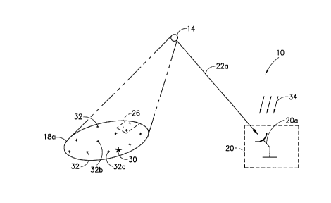
Referring to Figure 1, the geometry of a global radio
frequency map generating system 10 in accordance with this
invention is shown. In general, the system 10 comprises a
gateway 20 and a non-GSO satellite 14. The gateway 20 further
comprises several high-gain antennas, such as an antenna 20a
which communicates with the satellite 14. The satellite 14 is
positioned such that it hais an operational zone of coverage
defined by an L-band footprint 18a. Typically the L-band
footprint 18a is comprised of a plurality of individual beams
26. At any given time there may exist one or more desired
signal sources each represented as a user terminal 32 and one
or more L-band emitters 30 within the L-band footprint 18a,
CA 022347~8 1998-04-16
each of which whose position may or may not be dynamically
changing. For example, the user terminal 32 may be a mobile
radio device 32a (not shown) or a stationary radio device 32b
(not shown). The satellite 14 communicates with the antenna
20a, and ultimately with the gateway 20, through a feederlink
signal 22a.
Briei-ly referring to Figure 6, with regards to a CDMA MSS
system, the satellite 14 jLS responsive to specific frequency
channels C within the L-band sub-range R. As shown, there may
be currently 13 channels within the L-band sub-range R of 16.5
MHz. Channel 1 is designated as 1610.7 MHz. Each channel has
a bandwidth of 1.23 MHz, thus channel 13 is designated as
1625.8 MHz.
Turning back to Figure 1, in operation the satellite 14
receives L-band information from within the L-band footprint
18a. As previously described the source of the L-band
information may be a desirable signal from any one of several
user terminals 32 or a source of interference such as the L-
band emitter 30. The desired signal source of the user
terminal 32 may represent:, for example, a satellite user
terminal whose transmission may be adversely affected by the
L-ban,d emitter 30, which appears as a source of interference.
The L-band signal received by the satellite 14 is then
transmitted to the antenna 2Oa, modulated on an appropriate
frequency in the C-band range, where each beam 26 of the L-
band footprint 18a is separately processed at the gateway 20.
In a preferred embodiment, the gateway 20 uses the processed
L-band information to create an RF interference contour map
corresponding to the L-band footprint 18a. As stated above,
it is desirable to determine the extent of which the
interference is created by the L-band emitter 30.
As an illustration, assume that the C-band power measurements
are being made when the system 10 is operating with light
traffic loading. If there is one channel, typically 1.23 MHZ
wide, out of the allocated 16.5 MHz band that is unused by a
CA 022347~8 1998-04-16
user terminal 32 transmitting a desired signal, then any
'signal' measured at the gateway 20 in that channel would be
due to the combination of thermal noise, emissions at L-band
collected by the satellite 14, and C-band interference,
represented by arrows 34, where the C-band interference 34 is
due to extraneous energy collected by the gateway 20 antenna
20a at the feederlink signal 22a frequency. By calculating
the noise contribution from known system and environmental
noise sources, the inter~erence in that channel due to
emitt~!rs 30 in the satellite beam 26 being processed at the
gatewa~y 20 can be calculated. The C-band interference 34
corres,ponding to the feederlink signal 22a frequency can be
estimated by attaching a spectrum analyzer to the qateway 20
receiving antenna 2Oa when the antenna 2Oa is not pointing at
the sa~tellite 14. After subtracting the noise and feederlink
signal 22a contributions, the remainder may be assumed to be
due only to L-band emitters 30 in the satellite beam 26.
When the system 10 is fully operational, that is during normal
operations, it may not be possible to find a 1.23 MHz channel
that is unoccupied by user terminal 32 traffic. In this case,
it is possible to calculate the contribution of the desired
user terminal 32 traffic to the total uplink power and
subtract it out. The contribution of the user terminal 32
traffic at each time instant is calculated at the gateway 20
from operating system parameters available to the gateway 20,
and the number and location of users represented by the user
terminals 32 being served by the gateway 20. User terminal 32
location is obtained as part of the position location service
that will be offered by most of the MSS operators. Thus, the
signal-; associated with each user terminal 32 can be
subtracted from the initial C-band power measurement to reveal
the existence of L-band emitters 30 in a given beam 26.
Since user terminal 32 position information is available for
the analysis performed by the map generating system 10, the
fact that satellite 14 is a non-GSO satellite does not impact
the ability of the gateway 20 to determine the location of the
CA 022347~8 1998-04-16
~ ~ ~"
emitter 30. As the L-band footprint 18a moves with respect to
the surface of the Earth all user terminals 32, including
handheld mobile terminals 32a and stationary terminals 32b,
along with L-band emitters 30, will appear to be in motion
with respect to a given beam 26. The method of the map
generating system 10, however, dynamically maps the quasi-
movement of the user terminals 32 and emitters 30.
Now t:urning to Figure 2, a system 110 providing a more precise
method for determining the location of an undesirable L-band
emitt:er 30 is shown. The system 110 comprises at least two
non-C;So satellites. More specifically, the satellite 14 and a
satellite 12 of a non-G;O constellation are shown. The
satellite 14 has an opera1ional zone of coverage defined by
the I,-band footprint 18a. Similarly, the satellite 12 has an
operaitional zone of coverage defined by an L-band footprint
18b. The gateway 20 comprises several high-gain antennas such
as the antenna 2Oa and an antenna 2Ob. Each antenna tracks a
separate feederlink signal 22 from satellites 12 and 14. The
feederlink signal 22a corresponds to a signal transmitted from
the satellite 14 to the antenna 20a. Additionally, a
feederlink signal 22b corresponds to a signal transmitted from
the satellite 12 to the antenna 20b. As described above, each
satellite s L-band footprint 18a, 18b, is made up of
individual beams such as 26, and the signal from each such
beam 26 is separately processed at the gateway 20. The L-band
emitter 30 is shown in a region 28 where the two satellite
footprints 18a, 18b overlap. At the time instant shown, this
overlap region has a dimension shown as D. As the non-GSO
satellites 12, 14 move off' in different orbital planes, the
overlap region 28 changes in size and shape in a manner that
is predictable at the gateway 20. Desired signal sources
provided by user terminals 32 represent users in the system,
who may or may not be in the same frequency channel as the
emitter 30. Also shown is the external interference 34 at C-
band that is picked up by the gateway 20 antenna (20a, 20b)
sidelobes. Because of the directivity of the gateway 20
antennas 20a, 20b, the level of C-band interference 34 picked
CA 022347~8 1998-04-16
up b'~ the antennas 20a, 20b is typically small relative to the
feederlink energy.
Since each satellite 12, 14 typically has many beams Z6 that
cover a portion of the Earth's surface, a certain amount of
loca:Lization of the :interference emitter 30 occurs
immediately. Further narrowing of the position of the
interference emitter 30, however, can be obtained by
correlating, at the gateway 20 or a system network control
center, the received power from the satellites 12, 14 of the
system 110, given that the gateway 20 knows the satellite 12,
14 antenna patterns at L-band and C-band. In effect, this is
a form of triangulation to more accurately determine the
locat:ion of the interferer emitter 30. As the satellites 12,
14 move they cover different areas of the surface of the
Earth. Since the gateway 20 has knowledge of the satellite
12, :L4 locations and the positions of the user terminals 32,
as discussed above, it is possible to map the area swept by
the satellite 12, 14 beams 26, determining the location of the
interferer emitter 30 more accurately. By making measurements
in different L-band channels, interferer emitters 30 in the
entire 16.5 MHz band can be mapped.
Referring to Figure 3 a satellite 12, 14 payload 40 in
accordance with a preferrecl embodiment is shown. The payload
40 comprises a multi-beam ].-band antenna 42, a C-band antenna
44 and two transponders: a first transponder 46 suitable for
the MSS function and a second transponder 48. The first
transponder 46 is used to obtain an RF map of the world at
1610-1626.5 MHz and further comprises an L-to-C upconverter 50
and a corresponding power amplifier 52. The second
transponder 48 is tunable in the L-band and thus can be used
to monitor and map the rest of the L-band frequency range.
The ~;econd transponder 48 comprises a tunable L-band filter
54, an L-to-C upconverter 56 and a corresponding power
amplifier 58. Since no L-band signal is being emitted by the
transponder 48 in the remaining portion of the L-band, no
regulatory license is needed to modify the MSS payload by
CA 022347~8 1998-04-16
adding the transponder 4~ to the satellite 12, 14. The
incoming L-band signals are amplified by the multi-beam L-band
antenna 42 and the feederlink signals 22 are transmitted by
the low-gain global-coverage C-band antenna 44. The
feederlink 22 sub-band on which the satellite 12, 14 transmits
is d:ifferent for each uplink L-band beam. Note that it is
possible to provide the transponder 48 with a tunable filter
54a (not shown) which passes frequencies of other bands of
interest or to add another transponder 48a (not shown) to the
satellite 12, 14 payloacl, tunable to any other uplink
frequency while using the same satellite-gateway frequency as
the example system 110, and map the RFI in that uplink
frequency band.
Further precision may be had by maneuvering the satellite 12,
14 using an attitude central system 41 and momentum wheels 43,
or by steering the satellite 12, 14 using thrusters 49 and
propulsion system 47. A telemetry (TLM) and control system 45
can be used to direct the satellite antennas 42, 44 in a
pattern so as to isolate the interference source 30. A
conventional power system 51 provides operating power for all
of the illustrated satellite components.
Now turning to Figure 4, a block diagram depicting processing
functions to be used by each gateway 20 for generating an RF
interference map in accordance with this invention is shown.
In an initial step 62 C-ban~d power is measured in the received
feederlink signal 22 which corresponds to a particular beam 26
of a particular L-band footprint 18. In a step 64 the gateway
20 obtains various system parameter infor~ation from which a
power component related to thermal noise can be subtracted in
a step 66 from the measured C-band power resulting from the
step 62. In a step 68 t:he C-band power spectrum data is
obtained with the aid of a spectrum analyzer or other suitable
device, as previously discussed, and then subtracted from the
result of the step 66 in a step 70. Additionally, user
terminal 32 data represent:ing known locations of currently
active user terminals 32 is obtained in a step 72 and
CA 022347~8 1998-04-16
11
subtracted from the resultant of the step 70 in a step 74.
The resulting power measurement 80a is provided to a step 80
as a resultant from the step 74. It is important to note that
the order of the steps 6~, 70, and 74 may be interchanged
since they are not dependent on the determination of each
other. Thus, the step 70 could be performed subsequent to the
step 6Z and prior to the step 66.
In a~ step 76 satellite 12, 14 position information and
corresponding beam 26 contour data are obtained providing an
input: 80b to the step ~0. Additionally, in a step 78
satellite information from several satellites, regarding areas
where the L-band footprint 18 of at least two satellites
overlap, is correlated and provided as an input 80c to the
step 80. In the step 80 undesirable L-band emitter 30 signal
power and location information is determined for every L-band
emitter in current beam 26 and then stored in an RFI database
in a step 82. The steps 62 through 80 further define a
unified step 96 shown in dashed line. The RFI database
defines a radio frequency map, more specifically a radio
frequency interference map, wherein L-band interference
sources may be identified as to terrestrial location. As
previously mentioned, it should be understood that while a
standard MSS system satellite 12, 14 using the defined L-band
range of 1610-1626.S MHz for communications received from a
user terminal 32, the same method can be applied to RF mapping
of the world using other GS0 or non-GS0 constellations
operating in other frequenc~y bands.
If the system 10 uses distributed control, where a number of
gateways 20 communicate as a single unit and control a number
of satellites, some of these functions can be performed at
each gateway 20. However, if the network architecture uses
central control, these functions could be performed at the
network control center (not: shown). In any case, the system
10 malintains statistics on the interference emitter 30 power
it received in each channel C in each beam 26 at each time-
step, typically a minute. By compiling, at a central
CA 022347~8 1998-04-16
- 12
location, the history of data from different gateways 20, high
resolution, spatial and temporal, world-wide radio frequency
spectrum maps can be generated.
In ac:cordance with an aspect of this invention the gateway 20
and/c,r the central network control center of an MSS system can
use the RFI map defined by the step 82 to optimize its use of
limited system resources, such as frequencies and satellite
power. In particular, knowledge of external interference as a
function of time and space can be used by the gateway 20 or
network control center to assign mobile and handheld user
terminals 32a to frequency channels that have relatively low
interference, and fixed user terminals 32b (e.g. phone booths
on remote roads or villages that make use of the MSS) to those
with higher interference. This is useful because mobile and
handheld user terminals 32a typically have lower power
transmitters and lower gain antennas than fixed user terminals
32b. Therefore fixed user terminals 32b can operate at the
higher EIRP levels needed to overcome the interference in
noisier channels. Such an assignment of frequency channels
enables the system 10 to serve a larger total number of user
terminals 32.
Reallocation of user terminal 32 frequency channels C can be
achieved predictably or dynamically. If the L-band emitter 30
signal interference is found to be predictable, channel
reallocation for any given time period may be provided in
advan,-e. For example, if an L-band emitter 30 is consistently
activ,e during a specific daily time period, reallocation of
chann,el frequencies can be made automatic for this time
period. If the L-band emitter 30 signal interference is not
predi,-table, a dynamic channel reallocation of users is
possilble at the gateway 20 using sufficiently fast processors.
Also, note again that the use of this method is not restricted
to CDIMA systems. This method could be used for time division
multiple access (TDMA) systems, and for Frequency Division,
Multiple Access (FDMA) systems.
CA 022347~8 l998-04-l6
13
Now 1urning to Figure 5" gateway 20 procedures for an
examplary NSS system 90 using the radio frequency interference
database stored in the step 82 for channel c frequency
reallocation is shown. The C-band signal received at the
gateway 20 is demodulated in the gateway 20 RF equipment
during a step 92. The baseband output from this equipment is
format:ted in a first interface unit during a step 94 and then
provided as an input lOOa to a processor. In the step 96 the
processor performs the algorithms for calculating the radio
frequency interference as shown in Figure 4 and provides the
calcu]ation as an input lOOc to the processor. In a step 98
the processor performs a desired technique for resource
allocation. The processor 100 generates and stores the RFI
database in the step 82 as previously discussed. The
processor 100 later uses the stored RFI database 82 as an
input lOOb along with the resource allocation algorithms of
the step 98, as an input lOOd, to determine the channel
frequency reallocation. In a step 102 a second interface unit
reformats the processor output lOOe and converts it into a
user terminal 32 frequency channel assignment message in a
step 104. The frequency channel assignment message is
provided to a baseband-to-RF converter in a step 106 and
radiat.ed by the gateway 20 antennas, finally reaching the user
terminal 32. In response, the UT(s) shift their transmitter
frequencies accordingly.
This scheme for frequency reallocation after RFI mapping
applie!s to any system that divides its allocated bandwidth
into multiple frequency channels; each of these channels may
accommodate signals from multiple user terminals 32 by using
either CDMA, TDMA, or any other multiple access scheme.
With reference to Figure 6 and Figure 7, the frequency
reallocation scheme for an example MSS system 210 using
multiple CDMA channels is described in more detail. More
specifically, Figure 7 shows the system 210 comprising a
gateway g, a satellite s, an L-band beam b, and a number of
CA 022347~8 l998-04-l6
14
traffic concentrator gridpoints k. Each gridpoint k is
further comprised of at least one user terminal 32. The
system 210 can be modeled by covering the world with a set of
gridpoints k, and assuming user terminals 32 to be grouped
into the traffic concentrations at each gridpoint k. Figure 7
shows user terminals 32 located at gridpoints k covered by a
single beam b of a satellite s, and the gateway g processing
the signal from this beam b of the satellite s.
The MSS system bandwidth of 1610.7-1625.8 MHz in the example
system 210 is divided into the 13 channels C, each of them
1.23 MHz wide. Each of these 13 channels C is reused in each
L-band beam of the satellite, as shown in Figure 6. Several
user terminals 32 are assigned to each channel C and share the
channel using CDMA. A gateway g sends power control messages
to each user terminal 32 to set its transmit power to just
equal the value required to maintain a particular signal-to-
noise-plus-interference ratio (SNIR) given by ~hlN~r~qd-
The gateway g and/or the network control center performs theresource allocation by performing a time-step by time-step
simulation of the entire system 210.
At time-step t, let
YkC = the transmitter output power of a user terminal 32 at the
kth gridpoint traffic concentrator in a channel c.
The fact that the user terminal 32 power is limited is
expressed by the following constraint:
L-band user terminal 32 transmit power limit:
~k c: Yk /~ k C ~
where lv~c is the number of circuits at traffic concentrator
gridpoint k to be supported by the channel c on the return
link, and pmrNscr is the user transmit power limit, which is
CA 022347~8 l998-04-l6
about 1 or 2 watts for hand-held devices, approximately 3
watts for mobile devices, and approximately 10 watts for fixed
terminals (all of these values are exemplary).
The SNIR for each UT-satellite-gateway link can be expressed
using the equations given below.
For each gridpoint k, gateway g, satellite s, beam b, channel
c, and for each v,lk that is non-zero (where VSk has a value of
1 if gridpoint k sees satellite s and a value of zero
otherwise):
UTa~d /,~so~rl L('~ pdr t~txan~ Crc~
~ -- T Y~ Gk5 Gsbk Csh GTS Gg _ T ~ cl~srr~alv ( 2)
b Ik.~h~c bi, W l pa~ n~sc/ palhLn~is~ -- hil ~hF~
, ~ h~c Nl ,rr!qd = No ~ I ~L C + TC~ip ~Y~ cC~sbs lJ k~ (3)
1 '=1
In these equations,
Na is the total thermal noise due to both
uplink and downlink paths, measured at the
gateway receiver;
K = total number of gridpoints in the
satellite footprint.
Ic~,,c = external interference density in channel c
as measured at the gateway receiver;
ckJTa~t = UT antenna gain at the k h traffic
concentration in the direction of
satellite s;
c~lhk~ranl = satellite L-band receive antenna gain for
beam b of satellite s for traffic
concentration k;
G~rPdr = gain for the L-to-C transponder for beam b
of satellite s;
csCS~ranl = C-band transmit antenna gain from
satellite s toward gateway g;
Gs rc~ = C-band receive antenna gain of gateway g;
psalh = free space path loss from traffic
concentration k to satellite s;
n~lsc = the miscellaneous path loss (antenna
~0 pointing, polarization loss) from traffic
concentration k to satellite s;
CA 022347~8 1998-04-16
I,SPR'h = free space path loss from satellite s to
gateway g;
~misc = the miscellaneous path loss (tracking,
polarization and rain loss) from satellite
s towards gateway g;
C~Jhgr~C'' = total gain encountered by a signal in
going from a user at k to gateway g via
beam b of satellite s, as defined by Eq.
(S);
T~" = bit time, which is the reciprocal of data
rate; and
Tchfp = chip time, which is the reciprocal of chip
rate tl.23 MHz).
To meet the desired result ~hlN,~d we have, from Eqs. (2) and
(3),
T ~C,,~.r~clr
b,r
Eh / Nl.r~qd 1~1,. ( 4 )
NO + ~C~I c + Tc~ip~k'c(''k'5~g 1 *'
k'=l
It can thus be understood that the total noise power density
at the gateway g is the thermal noise NO, external
interference l~,c and system self-interference given by the
summation term. This summation term is dependent on the
powers Y~c due to each user terminal 32 that is visible to the
satellite s, weighted by the satellite s beam b antenna gain
and the user terminal 32 gain along the path from that user
terminal 32 to the satellite s. The satellite s antenna gain
for beam b is large for gridpoints k' close to the peak of the
beam b, and is decreased at gridpoints k' that are further
away from the beam b peak; for generality, the beam b is
assumed to have non-zero gain at all gridpoints k visible to
the satellite s.
Other system constraints, such as total satellite s power
consumed and power flux density limits on the ground, are also
expressible in terms of linear combinations of the Ykc
variables.
CA 022347~8 1998-04-16
17
The resource allocation algorithms in the gateway g involve,
at each time t, solving for the Y~c that satisfy Eqs. (1), (4)
and all other constraints using techniques such as iteration,
or numerical methods or linear programming; the objective of
the resource allocation is usually to maximize the sum of all
user terminals 32 served, expressed by
W = ~WkC
which represents the system capacity.
One of the challenges in the resource allocation is to assign
user terminals 32 to channels C in an efficient manner. As
Eq. (4) shows, users in channels that have high external
interference l~rl C need higher transmit power values y~c than
those in channels C with lower external interference Irr,C.
Since fixed user terminals 32b typically have higher EIRP
limits than mobile and handheld user terminals 32a, one
preferred channel assignment rule at the gateway g is to
assign fixed user terminals 32b to those channels that it
knows to have high external interference l~rlc r and to reserve
the channels with low external interference l~r/c for mobile and
handheld user terminals 32a.
It should be realized that the map generating system 10 could
also be used to map specific areas of space by simply
directing a receiving antenna of the satellite 14 at the
desired area and providing a transponder as part of the
satellite 14 with the appropriate tuning capabilities.
Additionally, while the method disclosed can be performed by a
single satellite, a GSO or non-GSO satellite, the method is
not limited to a specific number of satellites, GSO or non-GSO
satellites, or a combination of both.
CA 022347~8 l998-04-l6
18
It should also be realized that the various frequency bands,
numbers of channels, channel bandwidths and the like are
exemplary, and are not to read in a limiting sense.
Thus, while the invention has been particularly shown and
described with respect to preferred embodiments thereof, it
will be understood by those skilled in the art that changes in
form and details may be made therein without departing from
the scope and spirit of the invention.