Note: Descriptions are shown in the official language in which they were submitted.
CA 02238523 1998-05-26
WO 97/20235 PCT/GB96/02835
METHOD OF MONITORING QUALITY OF SEISMIC
DATA PROCESSING AND METHOD OF PROCESSING
VERTICAL SEISMIC PROFILE DATA
The present invention relates to a method of monitoring the ~uality of
surface seismic data processing and to a method of processing vertical
seismic profile data.
Surface seismic exploration can be performed in a 2D or a 3D mode.
The 2D mode is simpler to describe. Figure 1 of the accompanying
drawings is a schematic illustration of a simple 2D land based seismic
survey arrangement, although a similar surveying process can also be
carried out at sea. Only two sources and two receivers will be
considered for simplicity. The two sources S1 and 52 are regularly spaced
in an array to one side of an origin O. The two receivers R~ and R2 are
also regularly spaced in an array on the other side of the origin O. The
sources and receivers are arranged such that the origin is the rnidpoint
M, of a first source and receiver pair formed by S, and R" and also the
midpoint M2 of a second source and receiver pair formed by S2 and R2.
The dfstance between a source and a receiver is known as an "offset".
If a reflector 2 beneath the survey arrangement of figure 1 is horizontal,
then seismic energy emitted by the first source 51 will be received by the
first receiver R" whereas seismic energy emitted by the second source 52
will be received ~y the second receiver R2. In Figure 1, the midpoints of
the two described sourc~receiver pairs are at the origin O, and the
reflections occur d;rectly below the midpoints M1 and M2.
SUBSTITUTE SHEET (PzULE 26)
CA 02238523 1998-05-26
WO 97/20235 PCT/GB96/02835
In practice, the seismic energy sources are actuated in turn, and each
receiver receives reflected signals. The traces of received signals are
then assigned to a position which is the midpoint between the respective
receiver and the source that was actuated.
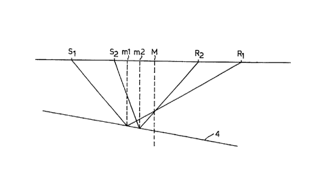
The presence of non-horizontal reflectors, known as dipping reflectors,changes the situation, as shown in ~igure 2 of the accompanying
drawings. The same pairs of sources Sl, S2 and receivers R1, R2 do not
now have a common reflection point on the dipping reflector, neither of
the reflection points being at the actual midpoint M between the sources
and receivers. During a processing sequence described hereinafter, the
object of a migration step is to determine the location of the actual
re~flection points, which, before migration, are assumed to have occurred
below the midpoint M as would occur with a horizontal reflector.
Th;s problem has been accounted for in the steps developed to process
surface seismic data. The processing of surface seismic data generally
includes a number of steps, each of which is intended to improve the
data quality. The processing often includes the steps of:
1) Designature - The shape of the input energy signature
is extracted from the seismic data and is then converted to one
of a known property wh;ch allows improved data processing
performance within the subsequent steps;
2) Gather - The seismic data are recorded such that
energy reflecting ~or apparently reflecting) frorn the same point
on a sub-surface is grouped together. These are commonly
called common mid points CMP or common depth points C~P;
SUBSTITUTE SHEFT (RULE 26)
CA 02238523 1998-05-26
WO 97/20~35 PCT/GB96/02835
3) Velocity analysis - The data within the CMPs contain
information from varying source receiver offsets. The time at
which reflection from a given point on a reflecting surface will
be recorded varies with source rece;ver offset and sub-surface
velocity. The varying time delay as a function of offset is
exploited in order to determine the subsurface velocity profile;
4) Deconvolution - Energy propagatlng from a source to a
receiver may undergo multiple reflections in addition to single
"primary" reflectors. These spur;ous multiple reflections are
attenuated by the deconvolution step. The deconvolution
process can compress the time series wavelet which represents
reflection at any given reflector and as such is an aid to
increasing resolution of closely spaced reflectors.
5~ Stack - The velocity profile derived at step 3 is used to
correct the recorded offset data to simulate data recorded at
zero offset. The corrected traces are then added together to
enhance a "primary" signal at the expense of ill corrected or
non-primary energy.
6) Migration - The gather and stack processing steps
assumed that the reflectors are horizontal. This results in errors
as indicated with respect to Figure 2. The migration step moves
any non-horizontal reflectors to their correct spatial position and
also focuses the seismic image;
7) Filtering - To remove frequencies not considered as
primary reflection energy.
SUBSTITUTE SHEET (RULE 26)
CA 02238523 1998-05-26
WO 97/Z023~ PCT/GB96/02835
Each process changes the data. It would be desirabie to monitor how
each process step affects a reflectivity se~uence and embedded wavelet
contained within the surrace seismic data.
Surface seismic acquisition is not the only way to obtain seismic data.Data may also be obtained by drilling a borehole and placing an array of
receivers on the ground surface and a seismic source in the borehole, or
by placing a seismic source on the surface, and an array of receivers at
various depths down the borehole. The latter option is the more
common arrangement. The resulting data are known as a borehole
vertical seismic profile.
A simplified arrangement is schematicaiiy illustrated in Figure 3 of the
accompanying drawings. A se;smic energy source Sb is located at the
top of a borehole 6 (represented by a dotted line in Figure 3).
Geophones C;l to G8 are located in a regular linear array at different
depths within the borehole.
Seismic energy resuiting from actuation of the source can travel directly
towards each of the geophones and the delay between actuation of the
source and arrival of the seismic energy can be used to derive a velocity
profile for seismic energy within the rocks through which the borehole
passes. Th;s direc~ly received seismic signal ;s not illustrated in Figure 3.
However, as iilustrated, seismic energy reflected directly from reflectors
deeper than the geophones can be recorded. Seismic energy paths for
geophones Gl, G4 and G8 have been illustrated. Some of the paths have
been siightly displaced with respect to one another to improve the clarity
of the diagram.
SUBSTITUTE SHEET ~RULE 26)
CA 02238~23 1998-0~-26
WO 97t20235 PCT/GB96/02835
A first path 8 represents energy that travels to the first reflector 2 and is
reflected to the first geophone Gl. A second path 10 represents energy
that travels to the second reflector 4 and is reflected to the geophone Gl.
A third path 12 represents energy that travels to the first reflector 2 and is
reflected to the geophone G4 just above the first reflector 2. A fo~rth
path ~4 represents energy that is reflected from the second reflector 4 to
the geophone G4. A fifth path 16 represents energy that is reflected from
the second reflector 4 to the geophone G8 located just above the second
reflector 4. The presence of a dipping reflector 4 enables ener~y
reflected from points positioned away from the path of the borehole to
be received by geophones located higher up in the borehole than the
reflector 4.
Figure 4 of the accompanying drawings schematica31y illustrates the
seismic record or trace recorded by each of the geophones G1 to G8.
Only reflection signals are shown. Direct arrival signals have been
omitted for clarity although, in order to generate a plot of the type shown
in Figure 4, the direct arrivai time from the source to a respective
geophone is added to the recorded reflection time by statically shifting
each trace downwards by an amount equal to its own direct arrival time.
In the absence of dip, such a time shifting causes upward reflections to
line up at their correct reflection times below the surface. Thus, the first
signals in the traces of geophones G1 to G4 resulting from reflection at
the first reflector 2 become aligned in time. The diagonal line 20
~ represents the two way travel time from the source to each geophone.
The origin in depth of a reflection event is precisely identified when the
reflection event is coincident with the line 20. Thus the first reflection in
the trace for G4 and the second reflection in the trace for G8 can be
SUBSTITUTE SHEET (RULE 26~
CA 02238523 1998-05-26
PCT/GB96/02835
W 097no235
identified as coming from reflectors whose depths correspond to the
positions of G4 and G8 within the borehole.
The reflections at the second dipping reflector 4 do not line up in travel
tlme but follow a hyperbolic curve. However, the time of the reflection
signal on the trace for the geophone G8 corresponds to the migrated time
for the corresponding reflection event in the surface seismic data. The
second reflection event on the trace for Gl corresponds to the zero offset
unmigrated surface seismic data. This is because, when the geophone
and source are nearly coincident at the sùrface, the trace recorded is
identical to the recorded zero offset surface seismic trace i.e. before
migration. Thus, the position in time of the second reflection on the
trace ~or geophone Gl is the same as the unmigrated surface seismic
time, and the position in time of the second reflection on the trace for
the geophone G8 is the same as the migrated surface seismic time.
Similarly, for the first reflector, the refiection event is correctly piaced in
time for trace Gl relat;ve to the unmigrated surface seismic data, and
correctly placed in time for trace G4 relative to the migrated surface
seismic data. Since the first reflector is flat, the migrated and unmigrated
times are the same. In the presence of dip, the unmigrated time is less
than the migrated time.
It is known to compare borehole vertical seismic profile data with surface
seismic data. However, except in the absence of dip, such a comparison
cannot be made until after the surface seismic data have been migrated
to a position equivalent to that of the borehole.
SUBSTlTU-rE SH~ET (RULE 26)
CA 02238~23 1998-0~-26
WO 97/20235 PCT/GB96/02835
According to a first aspect of the invention, there is provided a method
as defined in the appended Claims 1, tO and 12.
According to a second aspect of the invention, there is provided a
method as defined in the appended Claim 5.
Preferred embodiments of the invention are de~ined in the other
appended claims.
It has been found that, by seiecting the vertical seismic profile data trace
corresponding to least depth, for instance, of a geophone located in a
borehole, it is possible to perform quality control of surface seismic data
processfng at intermediate stages of sllch processing and, in particular,
prior to migration. For instance, this allows parameters of the various
processing steps to be optimised so as to improve the quality of the data
processing. Additionally or alternatively, the quality of processing can be
assessed at various intermediate stages so as to determine whether the
processing meets predetermined quality criteria. In the case where the
selected trace corresponds to zero depth, for instance with source and
geophone at the top of a borehole, the trace effectively comprises
unmigrated zero offset data. Where such a trace is not available, it has
been found possibie to extrapolate from the available vertical seismic
profile traces so as to simulate a trace corresponding to zero depth.
By deriving various other traces from existing vertical seismic profiie data
traces other than those described above, it is possible to perform quality
control of surface seismic data processing at intermediate stages and,
again, prior to migration. Such derived traces may not in generai have
any physical significance but can give useful indications of the quality
SU~ I I I ~JTE ~;HEE r ~RULE 26~
CA 02238S23 1998-OS-26
WO 97/20235 PCT/GB96/02835
and effectiveness of seismic processing prior to and during migration.
Different derived traces comprising different sections of the vertical
seismic profile data traces may be derived for use in such ~uality control.
For instance, determining which such derived trace most closely
resembies a trace generated during seismic processing may ailow one or
more processing parameters to be adjusted or optimised or may allow
assessment of the quality and effectiveness of the processing to be
determined. I lowever, the derived traces may also be useful in other
applications.
The invention will be further described, by way of example, with
reference to the accompanying drawings, in which:
Figure 1 is a schematic cross-section of the earth illustrating reflection of
seismic energy from a horizontal reflecting surface;
Figure 2 shows a schematic horizontal cross-section of the earth
iilustrating reflection of seismic energy by an inclined or dipping
reflecting surface;
Figure 3 shows a schematic cross-section of the earth illustrating borehole vertical seismic data acquisition;
Figure 4 is a graph illustrating simplified traces recorded by geophones in
Figure 3, with two way travel time of seismic energy being represented
on the vertical downward axis and the depth of the geophones on the
horizontal axis;
SU~ 11~ IJTE SHEET (RULE 26)
CA 02238523 1998-05-26
WO 97/20235 PCT/GB!)G~ 2&3!
Figure S illustrates a typical set of data traces of a bore hole vertical
seismic profile with geophones located at regular spacings throughout the
depth of the bore hole including zero depth, the axis being the same as
~ in Figure 4;
Figure 6 illustrates known 'section curves' for the data shown in Figure 5;
Figure 7 illustrates part of a section curve for explaining the derivation of
a derived trace;
Figure 8 illustrates section curves for an embodiment of the invention;
Figure 9 corresponds to Figure S but illustrates bore hole vertical seismic
~ data obta;ned for a lower portion only of the bore hole depth;
Figure 10 illustrates section curves of known type similar to those shown
in Figure 6 but for the data shown in Figure 9;
Figure 11 illustrates section curves for the data shown in Figure 9 and
forming an embodiment of the invention; and
Figure 12 illustrates extrapolation from the data shown in Figure 9
together with section curves forming an embodiment of the invention.
Figure 5 illustrates a set of bore hole vertical seismic profile samples
recorded by locating a seismic source at the surface and a plurality of
geophones in a bore hole. The geometry of the data was obtained by
means of an arrangement similar to that shown in fi~ure 3 but with
many more geophones, preferably equally spaced down the bore hole
SUBSTITUTE SHEET (RULE 26)
CA 02238523 1998-05-26
WO 97/20235 PCT/GB96/02835
~0
and extending from the top of the bore hole (at the surface~ to the
bottom of the bore hole. Each of the recorded traces is illustrated as a
vertical trace whose horizontat position represents the depth of the
geophone and whose vertical extent indicates the time intervai during
which reflected seismic signals are recorded. As in the case of Figure 4,
the direct seismic energy received by each geophone is not shown but
the line 20 represents the two way travel time of seismic energy from the
source to each geophone. The traces are shown as straight lines for the
sake of clarity but would normally have a form of the type illustrated in
Figure 4 representing the level of seismic energy received by the
geophones.
Figure 6 illustrates section curves of a known technique for deriving a
new trace from the recorded data traces. Figure 7 illustrates how a
derived trace is obtained from a section curve defined in Figure 4 as line
20 and the traces recorded by geophones. The section curve is shown at
29 and comprises a curve which intersects the traces 30 to 37. During a
time interval from zero to tl where the section curve 29 intersects the
trace 31, the derived trace comprises the section of the trace 30. During
the time interval between the times tl and t2 where the section curve 29
intersects the traces 31 and 32, respectiveiy, the derived trace comprises
the section between tl and t2 of the trace 31. During the time interval
between t2 and t3 where the section curve 29 intersects the traces 32 and
33, respectively, the derived trace comprises the section of the trace 32
between t2 and t3, and so on. Thus, the intersections of the section curve
29 with the traces define indicate the times at which the sections of the
derived trace are obtained from the respective recorded data traces.
SUBSTITUTE SHEET (RULE 26~
CA 02238523 1998-05-26
WO 97/20235 PCTIGB96/0283~;
11
Referring again to Figure 6, section curve 40 is applied to the data
illustrated in Figure 5 and corresponds to deriving the derived trace from
the uppermost sections of the recorded data traces. When the deepest
geophone trace is reached, the derived trace comprises that deepest
trace. As described hereinbefore with reference to Figure ~, the derived
trace resulting from the section curve 40 shown in Figure 6 corresponds,
for the curved part of the curve 40, to migrated zero offset data in
surface seismic data and extends throughout a time interval indicated by
the vertical bar 41 in Figure 6. This derived trace may be used in
surface seismic data processing to assess the quality of the fully migrated
data at least as far as the tirne t8 where the curve 40 corresponds to the
deepest geophone trace.
F;gure 6 illustrates another section curve 43 which extends throughout a
time interval indicated by the vertica~ bar 42. The derived trace resulting
from the section curve 43 represents a form of partially migrated or
intermediate data wh;ch has been used for quality control in surface
seismic data processing. However, the derived trace contains no data
until time tg is reached and does not therefore permit effective quality
control to be performed. Substantially less than full use of the bore hole
vertical seismic profile data is achieved and the section curve is such that
the derived trace is of only limited use in surface seismic data processing
quality control.
Figure 8 illustrates section curves cons~ituting embodiments of the
invention for application to the data of Figure 5. The first curve 45
comprises the trace from the geophone located substantially at the
surface, i.e. substantially at zero depth. Although such measurementS
have been available for a long time and were recognised as
S~tfS 111 ~JTE SHE~T (RULE 26)
,
CA 02238S23 l998-OS-26
WO 97/20235 PCT/GB96/02835
12
corresponding to unmigrated zero offset surface seismic data, the
possibility of using such a.trace in the quality control of surface seismic
data processing was not appreciated. It has been realised for the first
time that, surprisingly, such data is useful in controliing or assessing the
quality of surface seismic data processing. In particular, this trace may
be used to assess the ~uality of partialiy processed surface seismic data
prior to migration, for instance by cross correlation with a data trace
formed during processing. The trace 45 extends throughout the
recording period as indicated by the vertical bar 46 so that a full length
trace i5 provided, for instance for correlation purposes with partially
processed surface seismic data.
Figure 8 shows a section curve 47 constituting an embodiment of the
invention. The curve 47 represents an intermediate curve between the
curve 40 representing fully migrated data and the curve 45 representing
fully unmigrated data. The curve 47 intersects all of the actual data
traces so that the derived trace is made up of a section of each and every
recorded trace. Below the time tto where the curve 47 intersects the
trace from the deepest geophone, the derived trace comprises the trace
from the deepest geophone.
Although the derived trace corresponding to the section curve 47 does
not have any actual physical significance, it may be thought of as
representing partially migrated seismic data. As shown by the vertical
bar 48, the derived trace extends throughout the trace interval and thus
differs from the temporal extent of the derived trace from the known
curve 43 in Figure 6. The derived trace may therefore be used in quality
control of surface seismic data processing prior to completion of or
during a migration step when present. For instance, the derived trace
SUBSTITUTE SHEET (RULE 26~
CA 02238523 l998-05-26
WO 97/20235 PCT/GB96/02835
13
may be cross correlated throughout the entire trace interval with a data
trace generated during surface seismic data processing in order to
provide a measure of the quality of the data processing. This measure
may be used to alter processing parameters so as to improve the
processing quality, or to establish when an adequate quality has been
achieved.
Figure 9 illustrates bore hole vertical seismic profiie ciata in which the
geophones do not extend as far as the surface. Thus, there are no traces
corresponding to the upper part of the bore hole. Figure 10 illustrates
the section curves 40' and 43' of Figure 6 applied to the data of Figure
9. The derived traces corresponding to the section curves suffer from the
same limitations and disadvantages as described with reference to Figure
6. The time intervals corresponding to the derived traces are illustrated
at 41' and 42'.
Figure 11 illustrates section curves 40', 45' and 47' corresponding to
those shown in Figure 8 but appiied to the data shown in Figure 9. The
temporal extent of the corresponding derived traces are shown by the
verticai bars 41', 46' and 48' in Figure 11. Thus, the derived traces in
accordance with the section curves 45' and 47' achieve the same
advantages as in the case of Figure 8.
Figure 12 illustrates the derivation of a trace 50 corresponding to zero
depth and derived from the data shown in Figure 9. The trace 50 may be
derived in any suitable way, for instance by an extrapolation technique from
some or all of the actuai traces forming the data shown in Figure 9.
Aithough not shown, it is aiso possible to form other traces corresponding
SUBSTITUTE SHEET (PzULE 26)
CA 02238 j23 l998 - 0 j - 26
WO 97/20235 PCT/GB96/02835
14
to geophone locations between the surface and the uppermost actual
geophone iocation.
As described hereinbefore, the extrapolated trace 50 may itself be usedin quality control of surface seismic data processing. Refiection events
may be correctly located in the trace 50, for instance using an
extrapolation technique which detects reflections from horizontal
reflectors and places them at the same time point in the trace 50 and
which detects plane dipping reflectors and locates these appropriately in
the trace 50 by means of a hyperbolic extrapolation. For example, a
model of the subsurface can be used to generate a set of synthetic traces.
The synthetic traces are compared with the actual bore hole verticai
seismic traces to establish the strength of their correlation. If the
correiation is weak, the model can be altered and new synthetic traces
can be generated. The newly generated synthetic traces can again be
compared with the actuai bore hole vertical seismic traces. This process
can be repeated until a sufficiently strong correlation is founci between
the synthetic traces and the actual bore hole vertical seismic traces.
Using the model corresponding to the set of synthetic traces which moststrongly correlate with the bore hole vertical seismic traces, the trace
corresponding to the zero-depth trace may be derived from ail or some
of the actual actual bore hole vertical seismic traces by an extrapoiation
technique.
Alternativeiy, the data from the dipping reflectors can be corrected for
hyperbolic moveout and then extrapolated to trace 50 as for horizonta
refiectors. For example, a model of the subsurface can be used to
calculate a series of time corrections ~t for all or some of the actual bore
SUBSTITUTE SHEET (RULE 26)
CA 02238523 1998-OS-26
W 0 97/20235 PCT/GB96/02835
hole vertical seismic traces. The model is based on a known veiocity V,
where the angle of dip ~ is variable. For a given model, the time
corrections ~t are calculated for a particuiar angle of d;p ~ and a series of
depths and applied to some or ali of the bore hole vertical seismic traces.
The corrected actual bore hole verticai seismic traces are analyzed and
the angle of dip ~ is varied until a time correction ~t is obtained where,
at each time level, a reflection event is horizontally aligned.
In order to obtain the trace which corresponds to the zero~iepth trace
50, the left hand trace is taken, or the traces are summed utiiis;ng
techniques including, but not limited to, addition or median summing
across the corrected actual bore hole vertical seism;c data. Other
techniques may be employed as alternatives or in addition to the above
descr;bed techniques, for example, semblance and semblance weighted
techniques or cross entropy techniques.
It shouid be noted that the above example i5 not limited to a particLllar
time correction technique. For example, if the time correction does not
conform to a hyperbolic model, as would be the case if a dipping
reflector were not flat, then a different model based correction would be
appropriate. Such a correction co(lld be implemented either directfy on
the actual bore hole vertical seismic data or by comparison with
synthetic data.
The trace 50 corresponds to unmigrated zero offset surface seismic data
and extends up to a point in time which represents the zero depth
version of the real data at its shortest recorded two-way time, i.e. the
time represented by the intersection of the shallowest recorded trace 45'
and the two way travei time curve 40' in Figure 11 Thus correlation
SUBSTITUTE SHEET (RULE 26)
CA 02238523 l998-05-26
WO 97/20235 PCT/GB96/02835
16
with a processed data trace over an interval determined by this version of
the shortest travei time at the top to any point of the extrapolated real
data beiow can be performed.
As stated hereinbefore, pre-stack surface seismic data may contain datacorresponding to multiple reflections. Similariy, energy propagating from
a source to a given geophone used to record bore hole vertical seismic
traces may also undergo multiple reflections. These traces can be used
in conjunction with any of the methods described above in accordance
with the present invention.
The multiple reflections are removed using a deterministic method. The
subsequent ~ore hole vertical seismic data without the multiple
reflectlons are then used to derive traces corresponding to zero depth.
The data corresponding to multiple reflections are then reintroduced into
the derived traces corresponding to zero depth and used, in the same
way as without multiples bore hole vertical seismic data, to monitor the
quality of pre-stack surface seismic data.
Although references have been made above to time traces, i.e. the travel
time of a sound wave from a source, it ;s equally possible to refer to
depth traces instead of time traces. These are traces defined in terms of
distance travelled instead of time taken and are computed from the
recorded time traces utilising known velocities.
SUBSTITUTE SHEET (RULE 26)