Note: Descriptions are shown in the official language in which they were submitted.
CA 02247636 1998-09-17
19.233
METHOD AND APPARATUS FOR MEASURING RESISTIVITY OF AN
EARTH FORl\IATION
CROSS-REFERENCE TO RELATED APPLICATION
This application claims priority from Provisional Application 60/059,554, filed on
September 19, 1997, the contents of which are incorporated herein by reference.
BACKGROUND OF THE INVENTION
Field of the Invention
This invention relates to the field of well logging and, more particularly, to a method of
determining earth formation resistivity in real-time and at extended depths of investigation into
the formation. A form of the invention has general application to the well logging art, but the
invention is particularly useful in logging while drilling (LWD) and directional drilling
applications.
15 Description of the Related Art
Resistivity logging? which measures the electrical resistivity of formations surrounding a
borehole, is a commonly used technique for formation evaluation. Porous formations having
high resistivity generally indicate the presence of hydrocarbons, while other porous formations
having low resistivity are generally water saturated. Wireline well logging makes resistivity
20 measurements in a borehole (with the drill string removed) by lowering a logging device into the
borehole on a wireline cable and taking measurements with the device while withdrawing the
cable. This resistivity measurement technique uses various arrangements of sensors and
detectors~ on the logging device and at the earth's surface. to measure electrical currents and/or
potentials from which one derives formation resistivity.
~ .. . . . . .. .
CA 02247636 1998-09-17
During the directional drilling of a well in an earth formation it is necessary to determine
the trajectory of the well in order to ensure that the well is being drilled in the desired direction.
To accomplish the task of determining the well trajectory drillers take several measurements of
the drill bit and borehole conditions during the drilling process. These downhole measurements
include the inclination and direction of the borehole near the bit, which are essential for
maintaining accurate control over borehole trajectory. During the drilling process knowledge of
formation properties can be useful in connection with borehole trajectory control. For example,
identification of a "marker" formation, such as a layer of shale having properties that are known
from logs of previously drilled wells and which is known to lie a certain distance above the target
10 formation, can be used to great advantage in selecting where to begin curving the borehole to
ensure that a certain radius of curvature will indeed place the borehole within the targeted
formation. A shale formation, for example, can generally be detected by its relatively high level
of natural radioactivity, while a sandstone formation having a high salt water saturation can be
detected by its relatively low electrical resistivity. Once the borehole has been curved so that it
lS e~tends generally parallel to the bed within the target formation, these same measurements can
be used to determine whether the borehole inclination in the target formation is too high or too
low.
The focus of the present invention is in the area of measuring formation resistivity during
drilling operations. Resistivity measurements typically involve one of several techniques. The
20 first of these techniques uses a system of toroids and electrodes. An electrical current is
generated at a toroidal transmitter and passes into the formation. The current travels through the
formation and an electrode positioned at a distance away from the transmitter detects the current
or voltage drop. The formation resistivity is derived from the current and/or voltage
measurement. This electrode resistivity measurement technique is described in U.S. Patents
25 5,235,285; 5,339,036; 5.339,037; and 5 359,324, which are incorporated herein by reference.
A second technique for measuring resistivity is an electromagnetic wave propagation
measurement which measures the phase shift and/or attenuation of a signal between a pair of
receivers. E~camples of this technique are described in U.S. Patents 4.899.112 and 5.594,343,
which are incorporated herein by reference.
. .
CA 02247636 1998-09-17
' - A third type of resistivity measurement is the induetion technique. This teehnique
utilizes a system of eoils wrapped around a metallie or non-metallie mandrel and is described in
U.S. Patent 5,157,605, which is incorporated herein by reference. With the induction technique,
the signal at the reeeiver is proportional to the eonduetivity of the formation. The signal is
S generated by indueing eurrents in the formation and detecting voltage at the receiver.
These techniques are commonly used to determine formation resistivity with maximum
radial depth of investigation roughly equal to the maximum transmitter to receiver distance in the
logging apparatus. The maximum depth of investigation for typical wireline logging and LWD
systems is therefore generally limited to about 6 to 8 feet (1.8 to 2.4 meters) due to cost-driven
10 and practical limitations on tool length.
Referring again to the induction technique, induction tools employ alternating currents in
transmitter coils to set up an alternating magnetie field in the surrounding conduetive earth
formation. This ch~nging magnetie field induces current loops in the earth formation whieh
themselves produce a secondary magnetic field that is deteetable as a voltage by a reeeiver eoil
15 placed at a distance from the transmitter coil.
Generally, induction tools consist of multi-coil arrays designed to optimize vertical
resolution and depth of investigation. Figures I and 2 schematically illustrate a basic two-coil
wireline induction tool 8 deployed in a borehole 9. A two-coil tool comprises a transmitter coil 1
and receiver coil 2 mounted coaxially on a mandrel 3. Typical coil separations range from 1 to
20 lO t'eet (0.3 to 3.0 meters). In practice, each coil may consist of from several to a hundred or
more turns, with the exact number of turns determined by design considerations. A transmitter
oscillator 4 controls the operating frequency of the induction tool 8 which is generally in the tens
of kiloHertz (kHz) range~ with 20 kHz being the most commonly used frequency. The
transmitter coil 1 induces a current S in the earth formation 10 which is detected by the receiver
25 coil 2. This current forms a ground loop 6 around the tool. Receiver amplifier 7 amplifies the
received signal, from the secondary magnetic field generated by the sum of all the ground loops
in the formation~ for processing and further transmission uphole.
In spite of the fact that induction is referred to as a "resistivity" measurement, the voltage
induced in a receiver coil. with the direct mutual signal removed by design, is actually directly
30 proportional to the earth tormation conductivity rather than to the earth formation resistivity.
CA 02247636 1998-09-17
Col'it-ributions to the total conductivity signal from various individual regions of the formation
sum electrically in parallel, because the currents generated by the coaxial coil arrangement all
flow parallel to one another.
In addition to measuring formation resistivity, electrode and induction techniques have
5 other applications associated with logging while drilling operations. One such application is
downhole telemetry, which uses these techniques in the tr:~n.smi.ssion of measurement data
uphole to a receiver and eventually to the surface for interpretation and analysis. Electrode
telemetry is implemented by means of a transmitting toroidal coil antenna disposed on the tool
body which is energized to induce a current representative of measured data which current travels
10 in a path that includes the tool body and the earth formation. The tool also has an electrode
disposed on the body a distance from the transmitter. The electrode detects an electrical signal
resulting from the induced current and obtains the measurement data from the detected current.
This telemetry system is disclosed in further detail in U.S. Patent 5,235,285.
Effective downhole electrode telemetry must overcome several obstacles caused by the
15 electrical characteristics of the borehole and formation. During drilling and logging operations
drilling fluid passes through the tool to the drill bit. Drilling fluid also fills the borehole annulus
between the logging tool and the borehole wall. If this drilling fluid is oil-based and
consequently electrically resistive~ it will affect the signal strength during transmission. Still
another obstacle can be a very resistive formation or very conductive thin layers embedded in a
20 resistive formation. These types of layers are especially troublesome during telemetry
operations. Very resistive formations severely restrict the flow of current. This restriction of
current is analogous to an electrical open circuit. Where conductive formation lavers are
embedded in a resistive formation the flow of current to the receiver is prevented by the
conductive layers acting as a short circuit or creating a current pinching effect. Another obstacle
25 to transmission of signals uphole is the use of equipment? such as stabilizers. on the drill collars
between the transmitter and receiver. Such equipment can act as an electrical short which
prevents the telemetry signal from reaching the receiver.
Downhole induction telemetry overcomes several of the obstacles encountered by
electrode telemetry. A typical induction telemetry system comprises a transmitting antenna and a
30 modulator positioned at a first location downhole. A signal modulated to carry data acquired by
, .. . .
CA 02247636 1998-09-17
onè or more measurement sensors is applied to the transmitting antenna to induce a magnetic
field about the location. A receiving antenna, positioned at a second location uphole, intercepts a
portion of the magnetic field induced by the transmitting antenna and produces a signal that is
demodulated to yield the transmitted data.
The present invention comprises a method and apparatus for providing a real-time deep
resistivity measurement of earth formations with a depth of investigation ranging from
approximately 25 to 60 feet (7.6 to 18.3 meters) from the measuring instrument. The present
invention also describes an apparatus and method providing an improved telemetry system for
sending mèasurement data uphole. The resistivity measurement is derived from the induction
10 telemetry signal transmitted uphole.
It is therefore an object of the invention to measure formation resistivity at relatively deep
radial depths of investigation from the measuring device.
It is another object of the invention to effect a resistivity measurement using the telemetry
signal that carries data of measured parameters uphole to a receiver.
It is another object of the invention to detect formation boundaries while drilling,
especially in directional drilling applications.
It is a further object of this invention to provide for more effective formation resistivity
measurements and data transmission in the presence of electrically resistive borehole fluids.
SUMMARY OF THE INVENTION
The present invention comprises a method and apparatus for measuring earth formation
resistivity during the drilling process. It will be understood that conductivity, being the
reciprocal of resistivity, may be used interchangeably with that term in this specification. The
technique of the present invention uses the wireless induction telemetry signal being sent uphole
containing drilling information and other logging measurement information to effect a formation
25 resistivity measurement. In the telemetry process, a transmitter generates a magnetic induction
field in the earth formation that corresponds to the measurement data. The path of the
transmitted signal is at a relatively deeper radial depth into the formation than the measurement
signal of conventional logging tools. This relatively deeper signal path provides sensitivity to
formation resistivity at greater depths of investigation into the formation. A deeper resistivity
. . .
' CA 02247636 l99X-09-17
measurement gives the driller a better picture of the surrounding formation for controlling
drilling, information which is especially useful in directional drilling operations. The deeper
path of the signal is the result of the increased distance between the transmiKer and the receiver
which is achieved by placing these components in widely separated locations on the drill string,
5 rather than in a single tool. To further increase the transmitter to receiver distance the transmiKer
may be positioned in close proximity to the drill bit in a drilling assembly, and may preferably be
positioned in the bit box that connects the drill bit to the rest of a boKom-hole assembly (BHA).
Such an arrangement is described in U.S. Patent Application 08/921,971, the contents of which
are incorporated herein by reference. The receiver may be part of a measurement while drilling
10 (MWD) tool or may be placed in a separate sub. In order to increase the transmission strength in
view of the increased travel distance of the signal, both transmitter and receiver are loaded with a
ferrite core. The present invention uses the telemetry signal carrying drilling measurement and
logging data uphole to determine formation resistivity. During the transmission process the
measurement and logging data are modulated and transmiKed as data frames, such as 10
15 millisecond, l0 kHz pulses, via induction telemetry to a receiver located uphole from the
transmiKer. Electronics associated with the receiver demodulates the signal yielding the
measurement and logging data. Each pulse is demodulated by correlation with a reference 10
kHz signal. The demodulated signal and its quadrature are then squared and summed to be phase
insensitive. The receiver electronics also detects the amplitude of the telemetry signal. The
20 amplitude of the telemetry signal is used to determine the resistivity of the surrounding formation
by means of resistivity modeling.
Because of the depth into the formation of the transmission, the borehole and shallow
formation conditions do not affect the deep formation signal transmission to a large degree.
Therefore, the present invention overcomes the telemetry problems encountered under the
25 borehole and shallow formation conditions described above.
BRIEF DESCRIPTION OF THE DRAWINGS
The present invention will be better understood with reference to the appended drawings
wherein:
CA 02247636 1998-09-17
-'" Fig. 1 is a schematic illustration of the fundamental components of an induction
measurement apparatus;
Fig. 2 is a schematic illustration of the fundamental components of an inductionmeasurement apparatus deployed in a borehole;
Fig. 3 is a schematic illustration of the apparatus of the present invention deployed in a
borehole;
Fig. 4 is a diagram of an unaltered continuous carrier signal;
Fig. 5 illustrates a modulated carrier signal containing drilling and logging information;
Fig. 6 is a flow diagram of the operation of the present invention;
Fig. 7 is an illustration of a 27 bit word for data transmission uphole;
Fig. 8 is an illustration of a pulse position modulated data frame transmitted to a receiver;
Fig. 9 is a diagram of the pulse positions in a data region of the data frame of Fig. 8;
Figs. IOa, lOb, and lOc illustrate various pulse positions within a data region b,ased on
various bit sequences;
lS Fig. Il is a schematic of the circuit used to e~tract the carrier signal portion of the
transmitted signal during demodulation and to detect peak amplitude;
Figs. 12a and 12b illustrate respectively modulated signals as transmitted and as received
in the present invention;
Fig. 13 is a cross-sectional view of the transmitter of the present invention;
Fig. 14 is a plot of the signal amplitude resistivity transform for a two-coil deep
resistivity measurement svstem of the present invention;
CA 02247636 1998-09-17
Figs. 15a, 15b, lSc, and 15d are plots of the real and im~gin~ry signal resistivity
transform at various signal levels and transmitter to receiver spacings;
Fig. 16 is a schematic illustration of a tool according to the present invention approaching
a resistivity contrast boundary at an apparent dip angle of 90 degrees;
Fig. 17a is a graph of the formation resistivity signal response as the tool of Fig. 16
travels from a low resistivity formation to a high resistivity formation;
Fig. 17b is a graph of the formation resistivity signal response as the tool of Fig. 16
travels from a high resistivity formation to a low resistivity formation;
Fig. 18 is a schematic illustration of a tool according to the present invention approaching
a resistivity contrast boundary at an apparent dip angle of 0 degrees;
Fig. l9a is a graph of the formation resistivity signal response as the tool of Fig. 18
travels from a low resistivity formation to a high resistivity formation; and
Fig. l9b is a graph of the formation resistivity signal response as the tool of Fig. 18
travels from a high resistivitv formation to a low resistivity formation.
DESCRIPTION OF THE PREFERRED EMBODIMENT
The preferred embodiment of the present invention is implemented in a logging and
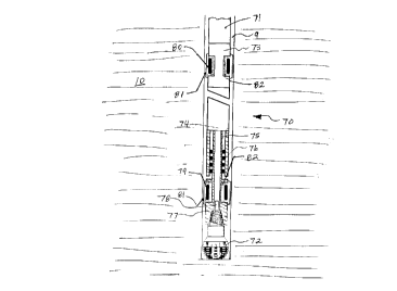
measurement while drilling system. Referring to Fig. 3, the apparatus of the present invention is
represented schematically in a borehole in an earth formation. A bottom-hole assembly (BHA)
70 for drilling a straight or directional borehole 9 in an earth formation 10 is suspended by means
of a drill string 71 which is supported at the earth's surface by a drilling rig (not shown). The
drilling rig provides power to rotate the drill string 71 and includes a mud pump to force
pressurized drilling fluid downward through the bore of the drill string 71. The drilling fluid
e~its the BHA 70 through ports in the drill bit 72 and returns to the earth s surface for reinjection
by the mud pump. The BHA 70 tvpically comprises a measurement while drilling (MWD) tool
73 and a positive displacement type drilling motor 74 which drives a bit shaft 75. The bit shaft
, .. . . ~, ,
CA 02247636 1998-09-17
75 is supported by bearings 76 and includes at its downhole end an extended bit box 77 into
which the drill bit 72 is threaded. Additionally, the drilling motor 74 may incorporate a bent
housing to facilitate the drilling of directional wells. It will be understood that the BHA 70 may
comprise other components in addition to those enumerated above, such as for example
stabilizers and logging while drilling tools.
Mounted within the e~tended bit bo~c 77is an instrumentation and electronics package 78
which is battery-powered. The instrumentation and electronics package 78 contains instruments
for making measurements during drilling and may include magnetometers for monitoring the
direction of the borehole, accelerometers for monitoring the inclination of the borehole, and/or
10 formation evaluation instruments. Mounted on the e~ctended bit box 77is a transmitter coil 79
for transmitting telemetry signals carrying encoded data from the various measuring instruments
through the earth formation 10 to a receiver coil 80 mounted in the MWD tool 73. It will be
understood that the transmitter coil 79 may be mounted in a separate sub and that MWD tool 73
may be placed at various locations within the BHA 70, such placement determining the depth to
15 which the received telemetry signals penetrate the earth formation 10. The transmitter coil 79
and the receiver coil 80 are protected from damage by shields 81 and are each loaded with a
ferrite core 82 to increase the transmission range of the system. Finally. the instrumentation and
electronics package 78 also carries the electronics necessary to encode the data fr~m the
measuring instruments and actuate the transmitter coil 79.
The invention uses the amplitude of the induction telemetry signal that transmits logging
and drilling data obtained during the drilling of a borehole to determine earth formation
resistivity. The transmitter coil 79 induces a signal in the earth formation 10 that corresponds to
the measured logging and drilling data. The receiver coil 80 detects this signal and electronics
associated with the receiver coil 80 recover the measured data for transmission to the earth's
25 surface by means of a mud pulse telemetry system in the MWD tool 73 or in a separate sub.
Such a mud pulse telemetry system is described in U.S. Patent 5,375,098~ which is incorporated
herein by reference. Before proceeding with the description of the invention, and to assist in
understanding the invention, some basic concepts related to signal transmission are reviewed.
As shown in Fig. 4. signal transmission begins with the use of a continuous oscillating
30 signal of arbitrary amplitude and frequency that carries no intelligence. This continuous signal is
... . . .
CA 02247636 1998-09-17
called a "carrier signal" or simply a "carrier". The carrier may be interrupted or the signal
amplitude altered so it becomes similar to a series of pulses that correspond to some known code
as shown in Fig. 5. At this point the oscillating interrupted signal can carry some intelligence. In
the present case, the intelligence is the measurement data. There are many ways to alter the
S carrier signal. Modulation is the process of altering a carrier signal in order to transmit
meaningful information. The type of modulation that is utilized in the present invention is Pulse
Position Modulation (PPM). PPM uses a pulse time arrival position in a data train to represent
quantitized values of data. The characteristics of pulses within a pulse train may also be
modified to convey the information.
Focusing again on the present invention, Fig. 6 shows the sequence of operations used to
determine formation resistivity. Data is gathered from measurements taken during a drilling
operation. The first step 11 is to generate a signal representative of the measured parameters.
This signal is in digital form and is a conversion of an analog measurement. To transmit this
signal to the uphole receiver it is necessary to encode the signal (box 12). The encoding process
15 produces a 27 bit word for transmission.
Fig. 7 illustrates a 27 bit word 22 that is ready for transmission to an uphole receiver. As
shown, this word may comprise several fields containing various types of data. In this example,
a 2 bit field 2~ serves as a frame counter of the number of frames transmitted uphole. T~Lis field
identifies each transmitted frame to permit better tracking of the transmitted data. Field 23 is a 2
20 bit field that serves as the frame tvpe field and identifies the type of measurement data in the
word. This data could be one of several measured characteristics such as temperature or bit
inclination. Field 25 is an eleven bit field that contains the actual measurement data. For
example~ an inclination measurement of 238 milli-g, which equals 76.2 degrees~ would be
00011101110 in field 25. Field 26 has two bits and indicates, for example, the shock level at bit.
25 In addition to the transmission of measurement data~ the bit stream may contain error detection
bits. These additional bits of the bit stream help detect if an error occurred during the
transmission of the data stream and verifies that the data sent was the data received. Error
detection schemes are commonly used in digital transmissions. The particular error detection
scheme may vary t'rom using only one bit to several bits depending upon the desired level of
CA 02247636 1998-09-17
detection, The last field 27 in this word is a ten bit error checking field that assists in verifying
accurate transmission of the data,
Referring again to Fig. 6, the next step 13 is to transmit the signal uphole. This
transmission involves modulating the signal using PPM techniques. As will be discussed in
5 detail below, the 27 bit word is transmitted uphole in a data frame. Encoded pulses contain the
information of the 27 bit word. Each pulse contains a l O kHz signal. The position of each pulse
in the data frame represents a portion of the data in the 27 bit word.
Fig, 8 illustrates the format of the transmitted and detected data in a PPM scheme, The
transmitter sends one data frame approximately every two minutes. The data frame 28 consists
10 of eleven l O kHz pulses. The data is encoded by using pulse position. The first pulse 29 and last
pulse 30 are synchronization pulses that indicate the beginning and end of the data frame 28.
The rem~ining pulses occur in data regions 31a-31i. The data regions are separated by intervals
32 of two seconds in length as shown. Referring to Fig. 9, each data region comprises multiple
positions within the region in which a pulse 34 may occur. Each data pulse position corresponds
15 to one of eight symbols whose value corresponds to the pulse delay position. There are seven
possible delay positions of 30 milliseconds or eight possible pulse positions I, II, III, IV, V, VI,
VII, and VIII. In an e~ample of the transmission of the ~7 bit word of Fig, 7, each of the nine
information pulses represents three bits of the 27 bit word. The data frame 28 contains the,se nine
pulses plus the two synchronization pulses 29 and 30. As shown in Fig. lOa. if the first three
20 digits of the 27 bit word are "lOl" the first data region would have a pulse 34 in the sixth
position. A three digit sequence of "Ol l " in Fig. l Ob would result in a pulse 34 in the fourth data
region. A sequence of"OOO" in Fig. lOc would result in a pulse 34 in the first position of the
data region.
Referring once again to Fig. 6, the modulated signal is received (box 14) and
25 demodulated (box 15) to obtain the data contained in the signal. As part of this demodulation
function, the carrier is extracted from the modulated signal. Fig. 11 shows a schematic of the
demodulation and carrier e~traction process. The signal sampled from the analog-to-digital
(AID) converter of the receiver electronics is first continuously multiplied by a reference l O kHz
cosine function and its quadrature sine t'unction. Both results are then summed over 10
30 milliseconds, squared~ and the results are added. The resulting square root corresponds to a
CA 02247636 1998-09-17
phase insensitive cross correlation of the incoming signal with a 10 millisecond, 10 kHz
reference pulse. As shown in Fig. 6, after demodulation the next step 16 is to detect a data peak.
A peak threshold applied to the cross correlated signal defines a peak or pulse whose time of
occurrence and arnplitude correspond to a maximum correlation amplitude.
Referring to Fig. 8, the transmitter sends data frame 28 to the receiver. As previously
mentioned, each data frarne includes a first pulse 29 and a last pulse 30 (synchronization pulses)
that indicate the beginning and the end of the data frame. In step 16, the receiver is constantly in
a search mode attempting to detect amplitude peaks. When the receiver detects a peak
amplitude, the receiver begins a search for a valid data frame 28. The search for a valid data
10 frame is necessary to determine if the detected peak amplitude was data or random noise. To
search for a valid frame the receiver checks for the presence of synchronization pulses. Since a
data frame has a duration of approximately 21 seconds, the receiver checks the previous 21
seconds for synchronization pulses and valid time of arrival for all intermediate data bearing
pulses.
After the detection of a valid data frame, the next step 17 is to reconstruct the 27 bit word
at the receiver. This step is a decoding of the pulses positioned in the data frame. Conventional
burst mode (27, 17) error detection techniques are now used (box 18) to determine the validity of
the transmitted word. Once it has been determined that the transmission is valid. the data is
extracted (box 19) from the 27 bit word. In the interpretation of the demodulated signal, the
measurement data transmitted in the signal is determined from the positions of the pulses. After
step 19, the focus of the procedure turns to the process of determining the formation resistivity.
Step 20 measures the amplitude of the carrier signal used during the transmission of the data.
Formation resistivity is determined (box 21) by comparison of the amplitude of the received
signal with that of the transmitted signal.
Fig. 12a illustrates the signal 38 as transmitted. Fig. 12b illustrates the signal 39 as
received. As shown. the received signal 39 resembles the transmitted si nal 38. However,
because the surrounding earth formation attenuates the carrier signal. the received signal 39 has a
much smaller amplitude than the transmitted signal. The formation resistivitv is calculated from
a resistivity transform that is dependent upon transmitter to receiver spacing in a homogeneous
formation as shown in Fig. 14. Where the well trajectory is at a relatively low apparent dip angle
CA 02247636 l998-09-l7
within geometrically complicated formation layers, the signal amplitude and a forward modeling
of the formation layers must be used to estimate a resistivity representation of the layers.
As previously stated, in order to increase the tr~n~mi.~ion range of the signal and
therefore the depth of investigation of the resistivity measurement, both the transmitter and
5 receiver are loaded with a ferrite core. Ferrite, or any material with high longitudinal magnetic
permeability, has a focusing effect on the longitudinal magnetic field used by the induction
transmission of the present invention. Fig. 13 shows a cross-sectional view of the transmitter 40
of the present invention. A protective electromagnetic transparent shield 41 encloses the antenna
42. This shield has slots 43 that provide for the electro-magnetic transmission of the signals. In
10this embodiment, the antenna 42 is comprised of a pressure tight spindle 44. Ferrite bars 45 are
longitudinally embedded in the spindle 44. Around the ferrite bars is wiring in the form of a coil
46. An epoxy ring 48iS adjacent the coil and ferrite bars. The coil is sealed by a VITON rubber
ring 47 for protection against borehole fluids. A slight void 49 exists between the shield 41 and
the VITON rubber ring 47 to allow for expansion of the ring 47 during operation.lSThe resistivity response or resistivity transform of the system of the present invention is
shown in Fig. 14 for a signal amplitude measurement. Fig. 14 shows the signal amplitude versus
formation resistivity for 25 foot (7.62 meter) and 40 foot (12.19 meter) 50 and S1. respectively,
transmitter to receiver spacings. As shown, the 40 foot (12.19 meter) measurement S1 can
discriminate resistivitv over a larger signal amplitude range. In both measurements~ the ability to
20 measure resistivity based on signal amplitude is minimal above appro~imately 20 ohm-meters.
One method tor extending the range of measurable formation resistivities above 20 ohm-
meters is to use the complex composition of the signal as in the standard induction technique.
The resistivity measurement includes the real component 54 (VR) and the imaginary component
53 (V,) of the signal as shown in Figs. lSa and I Sb. As indicated in Figs. I Sb and 1 Sd. the real
25 component 54 has a greater sensitivity to formation resistivity than the imaginary component 53
and can discriminate resistivity as a function of signal amplitude over a greater range. Since the
present measurement is an amplitude measurement 52 (V ~) represented by the equation
V~ = ~V,~ + V,-
CA 02247636 1998-09-17
and does not involve synchronizing of transmitted and received signals, a determination of the
real part of the signals is not possible. However, in this asynchronous system the range of
formation resistivity discrimination may be extended beyond 20 ohm-meters by using a higher
frequency signal, such as 100 kHz, which moves the resistivity transforms 50 and 51 of Fig. 14
to the right towards higher resistivity (approximately 100 ohm-meters). Additionally, the
resistivity of the formation at different depths of investigation may be determined from a single
transmitted signal by transmitting the signal pulses at different frequencies, each frequency
yielding a measurement at a different depth. In the present invention three frequencies,
approximately 2, 10, and 100 kHz are preferred. However, frequencies in the range from about 1
10 kHz to 300 kHz may be used.
Because of its large transmitter to receiver spacing, the present invention provides a deep
depth of investigation of formation resistivity. This feature is particularly useful in detecting
formation boundaries. Fig. 16 schematically illustrates a tool according to the present invention
operating at 10 kHz approaching a resistivity contrast boundary 56 at an apparent dip angle of 90
15 degrees. Figs. 17a and 17b show the resistivity signal response as the tool approaches and
crosses resistivity boundary 56 at an apparent dip angle of 90 degrees. As shown in Fig. 1 7a, at
200 ohm-meters 57, there is no change in resistivity across the boundary S6~ and therefore no
change in the signal. At a contrast of 20 ohm-meters to 200 ohm-meters 58~ there is virtually no
change in the signal, mainly because of the limited ability to distinguish resistivities above 20
20 ohm-meters when operating at 10 kHz. At a contrast of 2.0 ohm-meters to 200 ohm-meters 59,
there is a slight movement in the signal approximately ten feet (3 meters) before the tool reaches
the boundary 56 and more movement after it crosses the boundary. At 0.' ohm-meters to 200
ohm-meters 60. the signal begins to change rapidly approximately five feet (1.5 meters) before
the tool crosses the boundary 56. Fig. 17b shows that the responses are the opposite when
25 moving from a high resistivity formation to a low resistivity formation. There is a 10 to 15 foot
(3 - 4.5 meter) look ahead 61 when approaching the boundary 56 from a resistive to a conductive
formation.
Fig. 18 schematically illustrates a tool according to the present invention operating at 10
kHz approaching a resistivity contrast boundary 56 at an apparent dip angle of 0 degrees. Fig.
30 1 9a illustrates the resistivity signal response as the tool moves trom a low resistivitv formation to
CA 02247636 1998-09-17
a high resistivity formation at an apparent dip angle of 0 degrees. There is of course no change
in the 200 ohm-meter response 62 across the boundary. Again, the 20 ohm-meter response 63
shows virtually no change across the boundary 56. The 2.0 ohm-meter response 64 begins to
respond at approximately 40 feet (12.2 meters) from the boundary. The 0.2 ohm-meter response
S 65 begins to show a drastic change at about 25 feet (7.6 meters) from the boundary. The well
known horizontal or high angle horning effect when crossing a formation boundary causes the
0.2 ohm-meter response to exceed the 200 ohm-meter level and then return to the 200 ohm-meter
level. As shown in Fig. 19b, the tool response when moving from a high resistivity formation to
a low resistivity formation is essentially the opposite of that shown in Fig. 1 9a.
The present invention therefore provides a formation resistivity measurement with the
following characteristics: 1) deep resistivity radial depth of investigation proportional to the
distance between the transmitter and receiver; 2) vertical resolution also proportional to the
distance between the transmitter and receiver; 3) formation resistivity sensitivity of up to
approximately 20 ohm-meters when using the pulse amplitude resistivity transform at 10 kHz
lS operating frequency. or sensitivity up to approximately lO0 ohm-meters at 100 kHz operating
frequency; 4) the capability to detect formation boundaries based on changes in formation
resistivity; S) look-ahead capability when the bit is crossing from a low resistivity formation to a
high resistivity formation: and 6) look-around capability in wells drilled approximately parallel
to formation boundaries of any significant resistivity contrast. This application is significant for
20 landing wells and stayin_ within a predefined formation layer during directional drilling.
It will be recognized that new and improved methods and apparatus have been disclosed
which meet all the objectives and have all the features and advantages of the present invention.
Since certain changes or modifications may be made in the disclosed embodiments without
departing from the inventive concepts involved, it is the aim of the appended claims to cover all
25 such changes and modif'ications falling within the true scope of the present invention.