Note: Descriptions are shown in the official language in which they were submitted.
CA 022~04~1 1998-10-13
Earth Sensor
BACKGROUND OF THE INVENTION
Field of the Invention
The present invention relates to an earth sensor which
is mounted on a satellite or the like and which can stably
perform an attitude detection at a high precision.
Description of the Related Art
Heretofore, as a system of a sensor for executing an
attitude control of a satellite or the like or detecting
pointing angles of an observation sensor, there are various
systems such as mirror scan type, static thermal irradiation
balance type, conical scan type, and mechanical chopping
type. Particularly, as for a geosynchronous satellite in
which long life and a high precision attitude measurement are
demanded, a two-axis earth sensor of a mirror scan type has
been solely used in many cases.
Fig. 7 shows a constructional diagram showing an example
of a conventional earth sensor of the mirror scan type. In
the diagram, reference numeral 1 denotes an infrared
photodetector comprising a pair of single elements, namely, a
north scanning element for receiving lights which are spot
beams used for scanning of the north side of the earth and a
south scanning element for receiving lights which are spot
beams used for scanning of the south side; 2 an optical
package for enclosing the infrared photodetector 1; and 3 a
CA 022~04~1 1998-10-13
mirror for reflecting lights L which are spot beams used for
the scanning, thereby impinging on the photodetector 1.
Reference numeral 4N denotes a preamplifier for a signal
of the north scanning element; 4S a preamplifier for a signal
of the south scanning element; 5N a comparator which is
connected to the preamplifier 4N and which forms a pitch
pulse; 5S a comparator which is connected to the preamplifier
4S and which forms a pitch pulse; 6 a mirror scan drive
control unit; 7 a drive unit which has a drive coil and an
angle encoder and which outputs center pulses; and 8 an angle
generator (signal processing unit) for obtaining an angle
between the center of the earth and the west end and an angle
between the center of the earth and the east end on the basis
of pitch pulses PN and PS from the comparators 5N and 5S and
a center pulse PC from the drive unit 7.
In the earth sensor, as shown in Fig. 8(a), a spot beam
SN is allowed to scan the north side of the earth EA from the
west W to the east E and a spot beam SS is allowed to scan
the south side of the earth EA from the west W to the east E.
The lights L which are the spot beams SN, SS used for the
scanning are received by the single elements of the infrared
photodetector 1 and signals CN and CS having a waveform Py as
shown in Fig. 8(b) are generated. Those signals CN and CS
are amplified by the preamplifiers 4N and 4S, respectively.
The pitch pulses PN and PS having a waveform P~ as shown in
CA 022~04~1 1998-10-13
Fig. 8(c) are formed by the comparators 5N and 5S.
After that, on the basis of the pitch pulses PN and PS
from the comparators 5N and 5S and the center pulse PC from
the drive unit 7, angles ~lW and ~2W between the center of
the earth and the west end and angles OlE and ~2E between the
center of the earth and the east end are obtained by the
angle generator 8. By using those obtained angles 91W, e2W,
~lE, and ~2E, a pitch angle 6P and a roll angle ~R made by
the center of the earth and an optical axis of the earth
sensor are obtained on the basis of the following
expresslons .
~P = 1/4(- ~lW - ~2W + ~lE + ~2E)
~R = 1/2(~lW - ~2W + ~lE - ~2E)
As an example of the earth sensor having a construction
other than the above, there is the mirror scan type two-axis
earth sensor disclosed in Japanese Patent Application
Laid-Open No. 61-200099 (1986). The earth sensor uses a
division mirror arranged so as to enable to scan the upper
half portion and the lower half portion of the earth and a
scan mirror for reciprocatingly scanning the upper half
portion and the lower half portion of the earth right and
left.
As another example, there is the earth sensor disclosed
in Japanese Patent Application Publication Laid-Open No.
61-20480 (1986). The earth sensor is constructed in such a
CA 022~04~1 1998-10-13
manner that a plurality of infrared detectors for detecting
an image of the earth are placed to a periphery of a
substrate on which a thermal infrared image of the earth is
formed.
As a first problem point of the conventional earth
sensor, there is a problem that when the sensor is mounted on
the satellite, a mechanical vibration of a satellite body
which the satellite has interferes in the mirror drive unit
of the earth sensor, so that such an inconvenience that the
mirror drive unit causes mechanical resonance occurs.
For example, when frequency components of a wheel, a
solar paddle drive unit, the other devices having the
mechanical vibration, and the like are resonated with a
mirror torsion bar of the earth sensor, such an inconvenience
that a normal mirror scan cannot be performed or the like
occurs.
As a second problem point, there is a point that in the
conventional earth sensor, since its mechanical vibrating
mechanism system occupies a large area of the whole
structure, a realization of compactness and
light-weightedness is close to limits, so that it is
difficult to realize to further improve the compactness and
the light-weightedness.
CA 022~04~1 1998-10-13
SUMMARY OF THE INVENTION
The present invention is made in consideration of the
above situations and it is object to provide an earth sensor
in which there is no fear that a mechanical resonance is
caused, which can stably perform an attitude detection at a
high precision, and in which the compactness and
light-weightedness can be realized.
In order to solve the above problems, according to the
invention, there is provided an earth sensor which will be
described hereinbelow.
That is, there is provided a sensor comprising: a
substrate which is mounted on a satellite or the like and on
which an image of the earth is formed by scanning the earth
horizon; an infrared detector which is placed on the
substrate and which detects the image; and a signal
processing unit for processing an output signal of the
infrared detector, wherein the infrared detector has a
plurality of pixels arranged at predetermined intervals in
the direction which coincides with the scan of the substrate
and the direction which crosses the scan at a right angle,
respectively.
It is sufficient that the plurality of pixels are
arranged on the substrate in a matrix manner. It is also
sufficient that one of diagonal lines of the substrate is set
to the direction which coincides with the above-mentioned
CA 022~04~1 1998-10-13
scan and another diagonal line is set to the direction which
crosses the scan at a right angle, respectively. It is also
sufficient that an electronic scan is used as a scan. It is
also sufficient that a non-cooling two-dimensional array
infrared detecting element is used as an infrared detector.
According to the earth sensor of the invention, the
center of the infrared detector having a plurality of pixels
is set to an optical axis of the earth sensor, angles ~E, 9W,
9S, and ~N between an pixel of the center and pixels of the
end portions in the directions of the east, west, south, and
north are obtained by counting the number of pixels from the
center pixel up to the pixels of the end portions in the
directions of the east, west, south, and north, and a pitch
angle ~P and a roll angle ~R made between the center axis of
the earth and the optical axis of the earth sensor are
obtained on the basis of those angles ~E, ~W, ~S, and ~N.
Consequently, by counting the number of pixels from the
pixel at the center of the infrared detector up to the pixels
of the end portions, the pitch angle ~P and roll angle ~R
made by the earth center axis and the optical axis of the
earth sensor can be obtained, the mechanism such as a
conventional mirror drive unit which causes vibration is not
needed, there is no fear that mechanical resonance with the
mechanism is caused, so that the high precision pitch angle
~P and roll angle ~R can be obtained in a stable state.
CA 022~04~1 1998-10-13
Therefore, it is possible to stably detect an attitude
detection at a high precision.
Since the mechanical vibrating mechanism system such as
a conventional mirror drive unit is not needed, it is
possible to realize compactness and light-weightedness.
BRIEF DESCRIPTION OF THE DRAWINGS
Fig. 1 is a constructional diagram showing an earth
sensor of the first embodiment of the present invention.
Fig. 2 is a plan view showing a detecting element of the
earth sensor of the first element of the invention.
Fig. 3 is a graph showing a relation between pixels and
output signals of the detecting element of the earth sensor
of the first embodiment of the invention.
Fig. 4 is a constructional diagram showing an earth
sensor of the second embodiment of the invention.
Fig. 5 is a plan view showing a detecting element of the
earth sensor of the second embodiment of the invention.
Fig. 6 is a graph showing a relation between pixels and
output signals of the detecting element of the earth sensor
of the second embodiment of the invention.
Fig. 7 is a constructional diagram showing a
conventional earth sensor.
Fig. 8(a) to 8(c) are graphs showing a relation between
a detecting element and output signals of the conventional
CA 022~04~1 1998-10-13
earth sensor.
DETAILED DESCRIPTION OF THE PREFERRED EMBODIMENTS
Embodiments of an earth sensor of the present invention
will now be explained on the basis of the drawings.
[First embodiment]
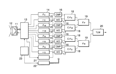
Fig. 1 is a constructional diagram showing an earth
sensor of the first embodiment of the invention. In the
diagram, reference numeral 11 denotes a non-cooling
two-dimensional array detecting element (infrared detector:
hereinbelow, referred to as a detecting element) having a
plurality of pixels; 12 an optical package for enclosing the
detecting element 11; 13 a reading circuit; 14 outputs (~E,
~W, ~S, ~N) of pixels of the east, west, south, and north;
and 15 analog peak holders (VE, VW, VS, VN) between pixels.
Reference numeral 16 denote comparators provided in
correspondence to the outputs (~E, ~W, ~S, ~N) of the pixel
of the east, west, south, and north. Each comparator
executes a normalization by the averaged pixel output and,
after that, performs a comparison. Reference numeral 17 A/D
converters provided in correspondence to the analog peak
holders (VE, VW, VS, VN) between the pixels. Each A/D
converters A/D converts the signal normalized by a reference
output in a manner similar to the comparator 16.
Reference numeral 18 adders for adding ~E, ~W, ~S, and
CA 022~04~1 1998-10-13
~N and VE, VW, VS, and VN with respect to the east, west,
south, and north, respectively, thereby obtaining (~E + VE),
(~W + VW), ...; and 19 angle generators for forming the pitch
angle ~P from ~E and ~W and the roll angle ~R from ~N and ~S,
respectivelyi 20 a telemetry data processor for joining the
pitch angle ~P and the roll angle ~R and generating the
resultant angle as telemetry data. A signal processing unit
is constituted by the adders 18, angle generators 19, and
telemetry data processor 20.
Reference numeral 21 denotes an analog signal normalizer
for forming a mean infrared intensity of the earth and
setting it as a reference level of each measured angle; 22 an
address generator for forming an address signal to read out
aE, ~w, as, ~N, VE, VW, VS, and VN; and 23 a reference clock
generator.
As shown in Fig. 2, the detecting element 11 is placed
on a substrate 31 on which an image I of the earth is formed
by scanning the earth horizon and detects the image I. In
the detector, a plurality of pixels 32, 32, ... are arranged
at predetermined intervals in the east and west (E-W)
direction (which coincides with the electronic scan) as a
pitch angle measuring direction and the north and south (N-S)
direction (which crosses the electronic scan at a right
angle) as a roll angle measuring direction of the substrate
31, respectively. In this instance, since the scan cannot be
CA 022~04~1 1998-10-13
directly performed in the measurement in the roll angle
measuring direction, the pixels 32 located on the center when
all of the scans in the east and west direction are executed
are lined in the north and south direction.
In the earth sensor, the pitch angle ~P and the roll
angle ~R made between the center axis of the earth and the
optical axis of the earth sensor are obtained on the basis of
the image I of the earth by the detecting element 11.
First, the center C of the detecting element 11 is set
to the optical axis of the earth sensor and the number of
pixels from a pixel 32C of the center C of the detecting
element 11 up to a pixel 32W on the west end is counted,
thereby obtaining ~W. Similarly, ~E is obtained by counting
the number of pixels from the pixel 32C to a pixel 32E on the
east end.
If the number of pixels 32 is sufficiently large, it is
possible to fairly obtain a demanded precision by merely
counting the number of pixels. When it is desired to further
improve the precision, however, it is sufficient that analog
levels of the pixels 32W and 32E on the east and west ends
are read, respectively.
Fig. 3 is a diagram showing a relation between the
pixels 32, 32, ... and output signals when an optical axis AX
of the earth sensor is moved from the west W to the east E in
the pitch angle direction (east and west direction).
CA 022~04~1 1998-10-13
In the diagram, a leading edge of the waveform is
changed because the angle corresponding to the atmosphere of
the earth is different depending on the altitude of the
satellite. For example, in a low orbit, although the
waveform becomes non-linear at the end of the pitch width of
the pixel 32, a continuity of the signal can be held due to a
repeat of a waveform WL.
In this instance, when the optical axis AX of the earth
sensor moves from a pixel 32W1 onto a pixel 32W2, as for a
micro angle fluctuation of the pitch angle ~P, the angle can
be read by approximating an angle of the output to the line
or setting it to the curve in a range of +~ and -~. That is,
the pitch angle ~P can be expressed by -3W2+~. The roll
angle ~R can be also expressed by the method that is entirely
similar to that of the pitch angle ~P.
In the earth sensor, the pitch angle ~P and roll angle
~R can be obtained by the following equations.
~P = 1/2{~E + VE - (~W + VW)} = 1/2(~E - ~W + VE - VW)
~R = 1/2{~N + VN - (~S + VS)} = 1/2(~N - ~S + VN - VS)
According to the earth sensor of the embodiment, since
the non-cooling two-dimensional array infrared detecting
element 11 having the plurality of pixels is used, a static
earth sensor can be constructed. Since the mechanical
vibrating mechanism system for the through scan such as a
conventional mirror drive unit is unnecessary, there is no
CA 022~04~1 1998-10-13
fear that mechanical resonance with those mechanisms is
caused. Therefore, the high precision pitch angle ~P and
roll angle ~R can be obtained in a stable state and the
attitude detection can be stably executed at a high
precision.
Since the electronic scan is executed by the non-cooling
two-dimensional array infrared detecting element 11, the
mechanical vibrating mechanism system such as a conventional
mirror drive unit is not needed, so that a small and light
earth sensor can be constructed.
In the earth sensor, as shown in Fig. 3, the continuity
of the signal can be held by the repeat of the waveform WL in
the low orbit. In a high orbit, however, since the dead zone
exists in the end of the pitch width of each pixel 32, when
the angle change occurs in the zone, the repeat of the
waveform WH becomes discontinuous, so that the angle change
cannot be continuously measured.
In case of the earth sensor, the pixels 32, 32, ...
exist in the whole area of the pitch width of the detecting
element 11. The dead zones exist because frames of the
pixels exist between the pixels 32, 32. Since an output
change area of the analog signal corresponding to the angle
change enters the area, when the altitude of the satellite is
changed, there is such an inconvenience that the measured
angle between the pixels becomes discontinuous, the linearity
.
CA 022~04~1 1998-10-13
is lost and the measuring precision is decreased, or the
like.
When the number of pixels 32, 32, ... of the detecting
element 11 is not sufficient, some analog process or a
special use is necessary. From the viewpoint of a resolution
and a visual field, it is insufficient. Then, we propose an
earth sensor of the second embodiment which will be explained
hereinbelow.
[Second embodiment]
Fig. 4 is a constructional diagram showing the earth
sensor of the second embodiment of the invention. The same
reference numerals shall also be applied to the same
component elements as those in Fig. 1 and explanations are
omitted.
In the diagram, reference numeral 41 denotes a
non-cooling two-dimensional array infrared detecting element
(infrared detector: hereinbelow, simply referred to as a
detecting element) having a plurality of pixels and reference
numeral 42 indicates an address controller for diagonally
re-scanning an inherent address circuit.
As shown in Fig. 5, the detecting element 41 is placed
on the substrate 31 on which the image I of the earth is
formed by scanning the earth horizon and detects the image I.
The pixels 32, 32, ... are arranged on the substrate 31 in a
manner of a matrix of m pixels in the longitudinal direction
CA 022~04~1 1998-10-13
x n pixels in the lateral direction. An axis of the east and
west direction of the earth is set to a diagonal line D1 of
those pixels 32, 32, ... and an axis of the north and south
direction of the earth is set to a diagonal line D2,
respectively. The pitch angle ~P is measured by the pixels
32, 32, ... on the diagonal line D1 and the roll angle ~R is
measured by the pixels 32, 32, ... on the diagonal line D2.
In this instance, the pixels 32, 32, ... arranged in a
matrix manner are expressed by using (m, n). ~W denotes an
angle on the west side from the optical axis of the earth
sensor and, similarly, ~E indicates an angle on the east
side, ~N denotes an angle on the north side, and ~S indicates
an angle on the south side.
Fig. 6 is a diagram showing a relation between the
pixels 32, 32, ... and output signals when the optical axis
of the earth sensor is moved on the diagonal line D1 of the
pixels 32, 32, ....
In the earth sensor, the normal electronic scan is
executed in accordance with the order of (1, 1), (1, 2), (1,
3), ... , (1, n-1), (1, n), (2, 1), (2, 2), .. , (m, n-1), and
(m, n).
After that, as shown in Fig. 6, the re-scan is executed
in accordance with the order of (1, 2), (2, 2), (2, 3), (3,
3), (3, 4), (4, 4), .... For example, the visual field of
the pixel (2, 3) increases as much as times in the
CA 022~04~1 1998-10-13
directions of the pitch angle 9P and roll angle ~R,
respectively. Therefore, an angle of visibility of the whole
earth sensor can be spread as much as ~2 times (about 1.41
times).
Although the resolution is inherently deteriorated as
much as , by using two lines of the line (1, 2), (2, 3), (3,
4), (4, 5), ... and the line of (2, 2), (3, 3), (4, 4), (5,
5), the resolution can be contrarily raised as much as ~2/2
u~ 0.7 times.
Further, since the pixels in the longitudinal direction
are overlapped in Fig. 6, a realization of subdivision of the
measured angle can be executed by only the signal near 0.5
when the output signals are normalized by 1Ø For example,
a waveform W22 near 0 and 1 of the pixel (2, 2) is non-linear
but a linearity can be finely held in the waveform near 0.5.
As for the other waveform W23 of the pixel (2, 3) and the
like as well, it is similar to the above. Therefore, the
precision of the measured angle between the pixels 32, 32,
..... ....can be improved.
In the earth sensor as well, the pitch angle ~P and roll
angle ~R can be obtained by the following equations.
~P = 1/2{~E + VE - (~W + VW)} = 1/2(~E - ~W + VE - VW)
~R = 1/2{~N + VN - (~S + VS)} = 1/2(~N - ~S + VN - vs)
As compared with the earth sensor of the first
embodiment in which the pixels 32 of only one line are used,
.
CA 022~04~l l998- l0- l3
16
according to the earth sensor of the present embodiment, two
lines are used, data is obtained so as to be overlapped,
thereby preventing the occurrence of the discontinuity.
Simultaneously, non-linear data in both of the upper and
lower ends are rejected and the angle is obtained on the
basis of data having a good linearity on the center.
Consequently, there is such an effect that the precision of
the measured angle between the pixels 32, 32, ... is improved
and, simultaneously, even when the altitude of the satellite
is changed, no discontinuous point occurs on the measured
angle and the measuring precision is not change.
Since the east and west axis of the earth is set to the
diagonal line Dl of the pixels 32, 32, ... of the detecting
element 41 and the north and south axis of the earth is set
to the diagonal line D2, respectively, and data is obtained
so that the pixels 32, 32, ... of two lines are overlapped,
the angle of visibility can be spread as much as ~2 times
and the resolution can be raised up to ~2 times as compared
with those of the earth sensor of the first embodiment.
Consequently, the performance is double, in other words, it
is equivalent to the detector which contains double picture
cells.
As mentioned above, according to the earth sensor of the
present invention, since the infrared detector is allowed to
have a plurality of pixels arranged at predetermined
CA 022~04~1 1998-10-13
intervals in the direction which coincides with the scan of
the substrate and the direction which crosses the scan at a
right angle, respectively, the mechanism such as a
conventional mirror drive unit which causes a vibration is
eliminated and a fear that the mechanical resonance with the
mechanism is caused is eliminated, so that the high precision
angle measurement can be executed at a stable state.
Therefore, the attitude detection can be stably executed at a
high precision.
Since the mechanical vibrating mechanism system such as
a conventional mirror drive unit is not needed, it is
possible to realize the compactness and light-weightedness.