Note: Descriptions are shown in the official language in which they were submitted.
CA 02252732 2001-07-17
76699-8
1
A METHOD OF AND APPARATUS FOR DETERMINING THE QUALITY OF
SEISMIC DATA
The present invention relates to a method of and an
apparatus for determining the quality of seismic data during or
after a seismic survey.
At present, the quality of a seismic survey is
generally determined by use of instruments or engineering
specifications located above a survey site, for example a fixed
U bar limit for ambient noise or a prescribed gun drop-out
limit. In some cases, failure to meet these criteria can lead
to a survey being halted unnecessarily, resulting in increased
cost through loss of production.
According to a first aspect of the present invention,
there is provided a method of determining a quality of a second
set of seismic data from a first set of existing seismic data,
comprising the steps of: (a) retrieving said first set of
existing seismic data; I;b) determining, from said first set of
existing seismic data, a minimum acceptable threshold
associated with a characteristic of said first set of existing
seismic data; (c) acquiring said second set of seismic data,
said second set of seismic data having one or more
corresponding characteristics, whereby said one or more
corresponding characteristics of said second set of seismic
data must remain above said threshold in order to determine
that said second set of seismic data is of acceptable quality
in accordance with a set of defined objectives; (d) comparing
said one or more corresponding characteristics of said second
set of seismic data with said threshold; (e) determining that
said second set of seismic data is of acceptable quality when
said one or more corresponding characteristics of said second
set of seismic data is equal to or greater than said threshold;
and (f) determining that said second set of seismic data is not
CA 02252732 2001-07-17
76699-8
2
of acceptable quality when said one or more corresponding
characteristics of said second set of seismic data is not equal
to or greater than said threshold.
Preferably, the threshold value is defined by
modifying a value of the characteristic derived from the first
set of seismic data using a model that calculates an expected
change to the value of the characteristic defined from the
first set of seismic data as a resu:Lt of a difference in the
acquisition parameters of the first set of seismic data and the
second set of seismic data.
The characteristic may be the resolving power, the
resolving factor, the signal-to-noise ratio, the effective
bandwidth, the delectability, the upper frequency range, or the
lower frequency range of the seismic data.
According to a second aspect of the present
invention, there is provided an apparatus for determining the
quality of seismic data, comprising: means for selecting a
characteristic indicative of the quality of seismic data; means
for defining a threshold value of the characteristic from a
first set of seismic data relating to a survey site; means for
deriving a value of the characteristic from a second set. of
seismic data relating to the survey site; and means for
comparing the value of t:he characteristic derived from the
second set of seismic data with the threshold value of the
characteristic to produce a measure of quality of the second
set of seismic data.
This invention also seeks to provide an apparatus for
determining a quality of a second set of seismic data from a
first set of existing seismic data, comprising: first means
CA 02252732 2001-07-17
76699-8
2a
for retrieving said first set of existing seismic data; second
means for determining, from said first set of existing seismic
data, a minimum acceptable threshold associated with a
characteristic of said first set of existing seismic data;
third means for acquiring said second set of seismic data, said
second set of seismic data having one or more corresponding
characteristics, whereby said one or more corresponding
characteristics of said second set of seismic data must remain
above said threshold in order to determine that said second set
of seismic data is of acceptable quality in accordance with a
set of defined objectives; fourth means for comparing said one
or more corresponding characteristics of said second set of
seismic data with said threshold; fifth means for determining
that said second set of seismic data is of acceptable quality
when said one or more corresponding characteristics of said
second set of seismic data is equal to or greater than said
threshold; and said fifth means determining that said second
set of seismic data is not of acceptable quality when said one
or more corresponding characteristics of said second set of
seismic data is not equal to or greater than said threshold.
The invention will now be described in greater
detail, by way of example, with reference to the accompanying
drawings, in which:
Figure 1 is a schematic diagram of a survey site;
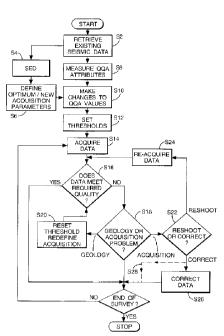
Figure 2 is a flow diagram showing method steps for
surveying the survey site of Figure 1 according to an
embodiment of the present invention;
Figure 3 is a schematic diagram of a step of Figure 2
in greater detail;
CA 02252732 2001-07-17
76699-8
2b
Figure 4 is a schematic diagram of an old and
predicted attribute in accordance with the embodiment of Figure
2;
Figure 5 is a schematic diagram of an old, predicted
and actual attribute in accordance with the embodiment of
Figure 2; and
CA 02252732 1998-10-27
WO 97/42526 PCT/GB97/01213
3
Figures 6 and 7 are areal plots of the survey site of Figure 1.
Referring to Figure 1, a marine survey site 2 comprises a region of low
loss and a region of high loss beneath the surface of the survey site 2.
The region of high loss, in this example, is due to a ridge. A set of well
bore data, for example, bore logs and VSP data from a well 4 and a set
of surface seismic data taken along lines 1,2 and 3 from previous seismic
surveys of the survey site 2 are available (not shown). The term "a set of
seismic data" includes one or more seismic traces.
The known well bore data and surface seismic data are retrieved (step
S2, Figure 2) and used to evaluate and design a new seismic survey (step
S4).
Referring to Figure 3, objectives of the new seismic survey, for example
formation depth, structural setting and lithological description of a
prospect model, are defined (step SED1) and a set of "required"
geophysical parameters are defined (step SED2), for example, target
resolution parameters, such as interval velocities, resolution requirements
and source energy.
The known well bore and surface seismic data are analysed (step SED3)
in conjunction with other available data, such as tidal information and
weather reports, in order to define a set of corresponding achievable
geophysical parameters (step SED4). For example, VSP data is used as a
measure for determining signal bandwidth. Other parameters include
temporal resolution, migration aperture, signal to noise ratio, spatial
resolution, offset distribution and azimuth distribution.
CA 02252732 1998-10-27
WO 97/42526 PCT/GB97/01213
4
The required and achievable geophysical parameters are compared (step
SEDS) in order to determine if the above objectives can be met and a set
of preferred acquisition and geophysical parameters are defined (step
SED6), provided that the required geophysical parameters are within the
scope of the achievable geophysical parameters. However, if the
required geophysical parameters are not achievable, the above objectives
are modified until the required geophysical parameters fall within the
achievable geophysical parameters (step SED7). Examples of the
preferred acquisition and processing parameters include source and
streamer depths, group and shotpoint intervals, in-line and cross-line
CMP spacing, record length, migration aperture, receiver offset range,
shooting direction, maximum feather, amplitude v. offset (AVO), dip
moveout (DMO), demultiple, noise suppression, imaging and sampling
interval.
The operational costs and constraints are then examined (step SED8) in
order to ascertain whether the preferred acquisition and processing
parameters are feasible on the basis of the costs and equipment
constraints. For example, resolution has a direct effect on the costs of
line spacing. If necessary, the objectives are redefined in order to take
account of the above constraints in order to provide the final "optimum"
acquisition and processing parameters.
Once a final set of optimum acquisition and processing parameters are
defined (step S6, Figure 2/ step SED6, Figure 3), a set of Quantitative
Quality Assurance (QQA) parameters are measured (step S8) for the
known data. On the basis of the final parameters (which may differ, for
example, in acquisition parameters from the known data), the QQA
values are modified (step S10) by modelling the expected changes due to
CA 02252732 1998-10-27
WO 97/42526 PCT/GB97/01213
the preferred parameters. The modified values are then used to define
the minimum acceptable threshold above which the attribute of the
newly acquired seismic data must remain in order to be of an acceptable
quality to attain the objectives defined. Such a situation can arise when,
for example, the known seismic data is acquired using deep streamer
cable and the evaluation and design of the new seismic survey indicates
that the optimum acquisition parameters should include shallow streamer
cable. Other parameters include: source depth, source volume, trace
interval and fold. Table 1 below shows old and new values of
acquisition parameters and the effect of changes therein on newly
acquired seismic data.
Parameter Old value New value Effect on new data
Source vol. 6400 cu in 3397 cu in Higher ambient
noise
Source depth 4m 5m Slightly lower
frequency
Cable depth 7m 7m None
Group interval16.667m 12.5m Shots have less
random noise
CMP interval 8.33m 12.5m Stack has more
random noise
Fold 60 40 Stack has more
random noise
Table 1: Effects of changes in acquisition parameter values.
CA 02252732 1998-10-27
WO 97/42526 PCT/GB97/01213
6
In order to define the thresholds, sample wavelets are taken from the
known surface seismic data. The surface seismic data can be surface
seismic data which has been calibrated against borehole derived
wavelets (where available) at intersection points between the surface
seismic data and the borehole location or theoretically calculated
wavelets using a given geological model. Various attributes or
characteristics of the wavelets, for example, the High Frequency Effective
Bandwidth (HFEB), are determined and a corresponding set of predicted
attributes are derived (Figure 4). The thresholds of the attributes are then
set (step S 12).
Table 2 shows an example of attributes and their threshold values.
Attribute Shots Stacks
Resolving Power 10 20
Resolving Factor 30 40
Signal to Noise 30 80
Detectabi I ity 100 1000
High Frequency (Hz)20 30
Low Frequency (Hz) 20 20
Table 2: Attribute thresholds.
Referring back to Figure 4, curve A shows the high frequency effective
bandwidth of the known seismic data and curve B shows the predicted
high frequency bandwidth for the new seismic data to be acquired. On
CA 02252732 2000-10-10
76699-8
7
the basis of curves A and B, a threshold value of 30 Hz is set
as the minimum value of the predicted HFEB (shown as broken
line C) within a margin of error.
The new seismic data is then acquired (step S14) and
one or more of the above mentioned attributes of the newly
acquired data is compared with the corresponding thresholds
(step S16). If the seismic data is of sufficiently good
quality (within specification), the or each attribute is equal
to or greater than the corresponding threshold and the
acquisition continues.
If the quality of the data is unacceptable (below
specification), the cause of the poor seismic data quality is
investigated (step S18). If the cause is found to be of a
geological nature, for example a ridge, all affected attribute
thresholds are modified or the acquisition redefined (step
S20), for example, by adjusting the depth of the streamers. If
it is found that the cause is acquisition related, for example
poor weather or equipment failure, a decision is made as to
whether to reacquire the affected seismic data, or whether to
simply correct it (step S22), for example, by correcting a
technical failure, such as air pressure or gun synchronisation.
If a decision is made to reacquire the seismic data, the
seismic data which is below specification is reacquired (step
S24) and step S16 is repeated (and steps S18 to S28 - depending
on whether or not the reacquired seismic data is within
specification). If a decision is made not to reacquire the
seismic data, the seismic data can either be corrected (step
S26) or if, deemed appropriate, the correction step is omitted
(see broken - step S28) and acquisition of the new seismic data
is continued.
CA 02252732 1998-10-27
WO 97/42526 PCT/GB97/01213
8
When the seismic survey of the survey site 2 has been completed or
during acquisition of the new seismic data, the actual high frequency
bandwidth or other attributes of the acquired seismic data can be
calculated and plotted. Curve D in Figure 5 represents the high
frequency bandwidth of the newly acquired seismic data and is above
the 30 Hz threshold previously set. This indicates that this attribute of
the newly acquired seismic data is within specification and so of an
acceptable quality.
An areal plot of the high frequency bandwidth or other attributes of the
newly acquired seismic data can be generated (Figure 6). The darker
regions of the plot represent areas of the survey site 2 where the high
frequency bandwidth attribute of the new seismic data is within
specification. The lighter regions of the plot represents areas where the
high frequency bandwidth attribute has fallen below an acceptable
quality threshold and so is below specification.
By comparing the areal plot of Figure 6 with the survey site 2 of Figure
1, it can be seen that there is a correspondence between the areas of
high loss of the survey site 2 and the lightly shaded areas, especially the
upper right hand quadrant of the areal plot. As described above, the
cause of such results has to be investigated to determine whether the
result is due to the geology of the survey site 2 or acquisition problems.
As another example, an areal plot of the resolving factor of the newly
acquired seismic data can be generated (Figure 7).
It is also possible to generate a final areal plot consolidating previous
individual plots relating to individual attributes.
CA 02252732 1998-10-27
WO 97/42526 PCT/GB97/01213
9
The areal plots can be generated in colour in accordance with a "traffic
light" scheme. Areas where an attribute is clearly within specification
can be plotted in green, areas where the attribute is marginally in or
below specification can be plotted in amber, and areas where the
attribute is clearly below specification can be plotted in red.
Although the above embodiment describes a 'real time' seismic survey
where the quality of seismic data is evaluated as it is acquired, it is
conceivable to evaluate the quality of the seismic data in accordance
with the invention once the entire survey site 2 has been surveyed.
However, the reacquisition of seismic data over areas having acquisition
related problems is no longer possible.
The above embodiment has been described in the context of a marine
seismic survey. However, it should be noted that the above invention
can be equally applied to land seismic surveys.
~ . ~ I .