Note: Descriptions are shown in the official language in which they were submitted.
CA 02257438 1999-O1-12
2
TRAFFIC DATA BROADCASTING SYSTEM
FIELD OF THE INVENTION
This invention relates to traffic data broadcasting and is particularly
concerned
with traffic speed data transmitted via a Digital Audio Broadcasting System.
BACKGROUND OF THE INVENTION
With a steady growth in automobile population, traffic congestion in major
highways is becoming increasingly severe, to the point where the original
purpose of the
highway system in terms of a transportation system is being defeated. This
problem has
led to a need for providing drivers on major highways with continuous
information on the
present state of the traffic in different highway sections to permit the
drivers to choose
less congested routes to their destination.
Conventionally, some traffic information is provided by electronic display
panels
mounted at various points in certain major highways. These systems are
expensive to
install, and as a result have not been widely used. Furthermore, they provide
only limited
information, being confined to text of limited length usually related only to
a particular
section of the highway system.
In U.S. Patents 5,173,691 and 5,164,904, Summer describes a data fusion
process
for an in-vehicle traffic congestion information system. This system gathers
raw traffic
data from a number of disparate data sources and formats the gathered data
into uniform
traffic congestion messages for each highway/road section based on a
specifically
described weighting and scoring algorithm. The formatted data is then
broadcast to
vehicles for further processing by an in-vehicle terminal for presentation to
the driver and
use in a text display, voice synthesis and/or map display colour-coded for
different levels
of congestion. Summer also teaches a call-messaging process at the in-vehicle
receiver to
select specific traffic congestion data relevant only to the cell (or zone) in
which the
vehicle happens to be, based on a navigational data processor within the
receiver system.
The system taught by Summer relies on the broadcasting through a narrow-band
channel
of discrete alphanumeric messages containing congestion information for each
highway
section, which can only be converted into a colour-coded graphic map at the in-
vehicle
CA 02257438 1999-O1-12
3
terminal if means for generating a background highway map is already available
in the
vehicle. Hence, most of the data storage and processing functions need to be
performed
at the in-vehicle terminal.
Several problems may arise with prior-art systems such as those referenced
above.
In the case where traffic information is presented to a driver in a text
format, there is a
risk of overloading the driver with a relatively large volume of traffic
messages. This
would be of specific concern in a major urban area, where the driver would be
looking for
information not just for the cell he/she is driving in, but rather for the
entire route to a
destination. Such a large volume of text messages would be difficult to absorb
and could
be dangerous to read while driving. In the case where traffic information is
presented to
the driver in a graphical format, a specialized complex terminal is required,
having a
processing power to convert a stream of text messages into a map. The
processing
requirement adds to the complexity of the in-vehicle electronics package and
hence and to
the terminal cost.
There has, therefore, been a need for providing automobile drivers or
passengers
timely traffic information of sufficient clarity and frequency to permit a
choice of more
suitable alternate routes to their destination at an affordable cost for the
in-vehicle
terminal. It is also desirable to provide additional information to assist
navigation, such
as weather or tourism data.
With the advent of Digital Audio Broadcasting (DAB) systems in Canada and
many other countries around the world, there is an opportunity to utilize such
a system for
broadcasting different types of data, at significantly greater bandwidth than
otherwise
available in conventional AM/FM broadcasting systems.
DAB is capable of not only producing high quality sound but also providing new
kinds of data services to the public. There are four significant technical
advantages in
using DAB over AM/FM systems.
1. DAB uses digital, rather than analog, transmission technology to produce CD-
quality
sound.
2. In Canada, DAB uses the Eureka 147 global technical standard, which
multiplexes
together a number of audio and data channels into one composite signal for
transmission.
CA 02257438 1999-O1-12
4
3. DAB uses frequencies in the band 1452-1492 MHz, which is part of the L-
Band, as
compared to the use of frequencies between 88 and 108 MHz for the FM radio
band and
540-1600 KHz for the AM band. The use of L-Band and Eureka 147 allows DAB a
relatively high bit rate of 2.4 Mbps, of which 256 Kbps is available for data
broadcasting.
4. Digital radio using Eureka 147 can carry substantially more ancillary data
than FM
sub-carrier systems.
With respect to the source of traffic information, there currently exist
several
systems that monitor traffic in major roads and highways on an ongoing basis.
As an
example, for the Metropolitan City of Toronto, Ontario, Canada, traffic speed
data are
available from sources including the Provincial freeway management authority,
City
freeway management authority, Public transit authority and Toll highway
operating
authorities.
There is clearly a need for a traffic data broadcasting system that makes use
of this
multiplicity of traffic data sources, while taking full advantage of the
relatively higher bit
rate provided by DAB in order to provide up-to-date traffic information on as
many roads
and highways as possible within a given service area, to travelling vehicles
to be
displayed at receiving terminals therein.
SUMMARY OF THE INVENTION
An object of this invention is to provide a traffic data broadcasting system,
comprising means for broadcasting over DAB systems, updated traffic speed data
related
to different road sections that may be received, processed and displayed at a
display fitted
within an automobile. It is another object of this invention to combine such
traffic speed
data with other types of data such as weather and/or tourism information.
In accordance with an aspect of the invention, there is provided a traffic
data
broadcasting system comprising:
a) traffic data fusion module for receiving at least one raw traffic data
stream related to a
road section from at least one traffic data source and for processing said raw
traffic data
stream into a traffic speed data file representing an average current traffic
speed in said
road section; and
CA 02257438 1999-O1-12
b) transmission means responsive to said traffic data fusion module for
periodically
broadcasting said traffic speed data file at a predetermined time interval,
e.g. once per
minute.
In an embodiment of the invention, data combining means is further provided
for
receiving at least one information data stream from an information data source
and for
processing said information data stream into an information data file provided
periodically to the transmission means for broadcasting. For example, the
information
data stream includes weather information in a textual and or graphic format.
Preferably,
the data combining means is interposed between the traffic data fusion module
and the
transmission means, to combine into combined data files the traffic speed data
file, the
information data file and a periodic configuration data file defining a
display layout in a
display terminal receiving said combined data files.
In an alternative embodiment of the invention, the transmission means
comprises:
a) interface means for converting each of the combined data files into a
formatted data
block suitable for Digital Audio Broadcasting; and
b) a Digital Audio Broadcasting transmitter responsive to the formatted data
block.
Preferably the data fusion module further provides periodically to the
transmission means
a road map data file representing a background road map. Conveniently, the
traffic speed
data file and the road map data file can be in graphical formats suitable to
permit a
graphic display terminal receiving the traffic speed data file and the road
map data file to
display the background road map showing the road section colour-coded for the
average
traffic speed. For example, the road map data file can be in a raster image
format,
whereas the traffic speed data file can be in a vector image format.
In accordance with another aspect of the invention, there is provided a method
of
broadcasting traffic data comprising the steps of:
a) receiving at least one raw traffic data stream related to a road section
from at least one
traffic data source;
b) processing the at least one raw traffic data stream into a traffic speed
data file
representing an average current traffic speed in said road section;
c) broadcasting periodically said traffic speed data file at a predetermined
time interval,
e.g. once per minute; and
CA 02257438 1999-O1-12
d) broadcasting periodically a road map data file representing a background
road map.
Preferably, the road map data file is in a raster image format, and the
traffic speed data
file is in a vector image format for conveying colour-coded information of the
average
current traffic speed in the road section.
In an alternative embodiment of the invention, the method of broadcasting
traffic
data further comprises the steps of receiving an information data stream, from
an
information data source, processing said information data stream into an
information data
file in a graphical format, and broadcasting periodically said information
data file. This
method can further comprise the step of periodically broadcasting at least one
configuration data-file, wherein said configuration data file includes layout
data for
controlling a display layout in a display terminal receiving the combined data
files.
Conveniently each one of the above indicated broadcasting steps is performed
via a
Digital Audio Broadcasting transmitter.
There are several aspects of DAB systems that are important to the invention:
1. Given the objective of distributing data to vehicles, radio receivers are
so ubiquitous
that virtually every vehicle has one. Almost every home has at least one radio
receiver
and many places of business also have radio receivers. These receivers are
anticipated to
become increasingly of the DAB type.
2. DAB receivers by definition have an interface for external data equipment.
3. The capability of DAB to distribute third party data is substantial. The
Eureka 147
standard that has been adopted by Canada can support several hundred Kbps of
data in
addition to the regular audio program channels.
BRIEF DESCRIPTION OF THE DRAWINGS
Exemplary embodiments of the invention will now be further described with
reference to the drawings in which:
Fig. 1 illustrates in a block diagram a broadcasting system for transmitting
traffic speed
data in accordance with an embodiment of the invention;
Fig. 2 illustrates in a block diagram a broadcasting system for transmitting
traffic speed
data combined with other types of information in accordance with another
embodiment of
the invention;
CA 02257438 1999-O1-12
Fig. 3 illustrates elements of a Digital Audio Broadcast system including a
preferred
embodiment of the invention; and
Fig. 4 illustrates an in-vehicle display panel receiving combined traffic and
other data
broadcast via the system shown in Fig. 3;
wherein identical numerals are used to refer to the same elements throughout
the above
figures.
DESCRIPTION OF THE INVENTION
Overall System
Table I defines the sources, the types of sensors used to obtain the traffic
data, and
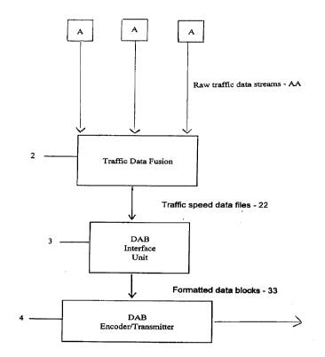
the content of the data that are received from the information providers. Fig.
1 illustrates
a block diagram of a broadcasting system for transmitting traffic speed data
in accordance
with an embodiment of the invention. In this embodiment a multiplicity of
traffic data
sources A are shown available to provide real-time raw traffic data streams AA
related to
ongoing traffic in different corresponding road sections. Some of these
traffic data
sources provide traffic speed information for each section of the road/highway
covered,
while others provide information on the momentary position of vehicles (buses
or
vehicles with toll transponders) moving along each section of the road/highway
covered.
This traffic information comes in different technical formats and protocols
which are to
be standardized by the embodiment described herein.
A traffic data fusion module 2 periodically receives these traffic data
streams AA
and processes them into traffic speed data files 22 to simultaneously
represent average
current traffic speeds at different road sections. The traffic speed data
files are then
provided to transmission equipment consisting of a Digital Audio Broadcasting
(DAB)
interface unit 3 and a DAB encoder/transmitter 4. The DAB interface unit 3
converts the
traffic speed data files 22 into formatted data blocks 33 suitable for DAB
transmission,
which are then fed to the DAB encoder/transmitter 4 for transmission over one
of the
DAB radio frequency channels.
Fig. 2 illustrates in a block diagram another embodiment of the invention for
transmitting traffic speed data files combined with other types of data
information. The
CA 02257438 1999-O1-12
8
embodiment shown in Fig. 2 contains all the elements of that shown in Fig. 1
with the
addition of further elements as described herein. One or more information data
sources B
are shown in Fig. 2 which are available to provide other types of data streams
BB
containing information likely of interest to a vehicle driver or passengers,
such as weather
and tourism information. A data combiner 6, interposed between the traffic
data fusion
module 2 and the DAB interface unit 3, receives these information data streams
BB,
processes them into information data files SS, and is also provided with
traffic speed data
files 22 by the traffic data fusion module 2. In addition, the data combiner 6
periodically
generates a configuration data file for defining a display layout in an in-
vehicle display
terminal, and combines this configuration file with the traffic speed data
files and the
information data files into combined data files 66 containing both traffic and
other types
of information. The combined data files 66 are then provided to a DAB
interface unit 3 to
format the data into formatted data blocks 33 and have these available for
transmission by
the DAB EncoderlTransmitter 4 as explained above with respect to Fig. 1.
Main System Components
To understand the entire operation of a traffic data broadcasting system that
includes the invention, Fig. 3 illustrates all the elements of such a system
showing both
the transmitting and receiving sides. For the purpose of illustration only,
the description
is of a system which is tailored for use in the City of Toronto, Ontario,
Canada. As
shown in Fig. 3, raw traffic data streams AA are received from four data
sources A:
1. Ministry of Transportation of Ontario traffic management computer system;
2. City of Toronto Authority traffic management computer system;
3. Toronto Transit Commission bus management computer system;
4. Traffic speed data obtained from fleet management software that tracks the
location of
vehicles in a fleet using Global Positioning System (GPS) receivers and radio
transmitters
installed on each vehicle in the fleet. Dividing the distance moved by the
vehicle by the
elapsed time between the two positions leads to the average speed of the
traffic on that
particular section of road.
5. Additional traffic speed sensors that are installed on the side of or above
the road to
fill in the gaps in the data from the above three sources.
CA 02257438 1999-O1-12
The traffic data streams AA from the data sources A are received by the
traffic
data fusion module 2 and processed to create traffic speed data 22 suitable
for an
integrated map display of traffic speeds on highways and major arteries. To
accomplish
this, software within the fusion module 2 receives the raw data streams AA
from the
various sources A, convert them to a standardized format and enter the data
into a real-
time database. Each field in the database represents a discrete section of
road/highway in
a specific direction. Processing and conversion of the data to a standardized
format is
required because each of the above indicated agencies uses a different
technical standard
for its data, and because some agencies provide information on momentary road
positions
of vehicles which needs to be translated into average traffic speeds.
In regards to expressways such as Ontario Highway 401, the database captures
the
speed of traffic for the express lanes in each direction as well as the
collector lanes in
each direction. A separate element of the software in the fusion module 2 then
reads the
contents of the database and creates a graphic data file in the form of a
vector image file
to represent a visual, colour-coded map of the traffic speeds on the highways
and roads in
Toronto covered by the traffic data broadcasting service provided in
accordance with this
invention.
A data combiner 6 as shown in Figs. 2 and 3 combines the traffic speed map
with
weather information received from Environment Canada and possibly tourism
data. This
will create combined data files 66 that comprise multiple types of
information. The
combined data files 66 are then provided to the DAB Interface Unit 3.
An ancillary data input on the Digital Audio Broadcasting (DAB) transmitter 4
has
specific technical requirements, such as the data rate, whether the data is
synchronous or
asynchronous, and the specification of data headers on the blocks of
information. The
DAB interface unit 3 converts the combined data files 66 into formatted data
blocks 33 as
required for an input to the DAB transmitter 4. The DAB encoder is typically
an integral
part of the transmitter 4 equipment but is identified in Fig. 3 separately
because of its
importance. The Eureka 147 Digital Radio global standard adopted by Canada
requires
that each audio and data channel be encoded and then multiplexed with other
audio and
data channels.
CA 02257438 1999-O1-12
Fig. 3 shows a Web Server 11 receiving combined data files. This web server
can
be accessed in one of two ways:
1. Subscribers to the traffic data broadcasting service having access to the
Web site for
pre-trip planning from home or the office; or
2. A time-delayed version available to non-subscribers as part of the
promotion of the
service.
A user authorization control unit 7 is shown in Fig. 3, which is to permit the
traffic
and weather data to be broadcast in an encrypted form to ensure that only
paying
subscribers can receive it. There are four alternative ways to do this:
1. Use the electronic addressing feature of the Digital Radio receivers;
2. Incorporate encryption and addressability in the software used in the
display panel and
the notebook computer;
3. Incorporate encryption and addressability in the display panel hardware; or
4. A combination of the above.
A Network Service Quality Monitoring System 13 is provided for the monitoring
of the network and the data channel. This includes an in-vehicle Digital Radio
receiver
and computer that monitors the channel data signal twenty four hours per day.
If there is
an outage or if the data is corrupted in some fashion, the system will
automatically alert
key people using a combination of paging and dialling telephone numbers and
playing a
pre-recorded message.
Svstem Software Functions
In the following, specific design aspects of the above-described embodiments
are
given in more detail.
The overall design of the software used within the data fusion module 2 and
data
combiner 6 is based on eight individual data files that fall in one of two
categories:
A. Data files that change relatively infrequently; and
B. Data files that change relatively frequently.
These categories define the periodic time interval or frequency of
transmitting updates
and whether the file, after being received at an in-vehicle terminal, is to be
stored in the
display panel in a non-volatile memory. Table II lists all eight files that
are transmitted or
CA 02257438 1999-O1-12
11
downloaded, together with information on the storage approach and
transmission/download frequencies. As shown in Table II, some of these files
change
relatively frequently and are therefore transmitted approximately every
minute, while
others change relative infrequently and are only transmitted approximately
every fifteen
minutes. These categories also define whether the file is stored in the in-
vehicle display
panel in volatile or non-volatile memory. However, the files are not sent all
together in a
block every minute or every fifteen minutes. Instead, there is a controlled
sequence of
transmissions that ensures that:
a) over the course of each 1-minute interval, each "once-per-minute" file is
transmitted
once, and
b) over the course of each 15-minute interval, each "once-per-15-minute" file
is
transmitted once.
Traffic Data Fusion Functions
The software module within the Traffic Data Fusion module 2 performs the
following operations:
1. Manage the reception of files from:
a) Ministry of Transportation of Ontario traffic management computer system;
b) City of Toronto Authority traffic management computer system;
c) Toronto Transit Commission bus management computer system;
d) Additional traffic speed sensors that are deployed to fill in the gaps in
the data from
the above three sources.
These files contain traffic speed data in different formats. Each source
provides a new
file approximately once per minute.
2. Maintain a real-time database of the current speed of traffic on each
section of
approximately one kilometer (and in each direction) of the highways and roads
covered
by the traffic data broadcasting service. (For Highway 401, the database
maintains
separate traffic speeds for the express lanes and collector lanes.)
3. Approximately once per minute, prepare and transmit a file that comprises
all traffic
speeds for the highways and roads covered.
4. Approximately once every fifteen minutes, during the intervals when traffic
speed data
is not being transmitted, transmit a graphic file containing the background
map in the
CA 02257438 1999-O1-12
12
format of a raster-scan image.
5. Generate a file for the traffic speed legend and transmit/download it once
every fifteen
minutes.
All the files are sent as graphic files using a standard graphical format;
this
minimizes the amount of processing required in the in-vehicle terminal. More
specifically, most files are sent in standardized graphical formats such as
the well-known
JPEG format, except for the road and traffic information. The background road
map of
the area covered is sent as a raster-scan image whereas the traffic speed
overlay is sent as
a vector image file.
Data Combiner Functions
The software within the data combiner 6 performs the following functions:
1. Store a configuration data file that defines a display layout in terms of
the size and
location of each window in the in-vehicle display and transmit/download this
file with the
set-up information once every fifteen minutes.
2. Manage the reception of data from an Environment Canada receiver in a
graphical
or textual format and extract weather information for the Toronto area.
3. Prepare a file of the summary weather information window in a textual
format and
transmit/download it approximately once every fifteen minutes. (In case a
weather
warning is issued by Environment Canada for the Toronto area, the summary
weather file
is updated and transmitted or downloaded within one minute.)
4. Prepare a file of the detailed weather information window and
transmit/download it
once every fifteen minutes. (If a weather warning is issued by Environment
Canada for
the Toronto area, the detailed weather file is updated and transmitted or
downloaded
within one minute.)
5. Store up to one hundred advertisement files and a file that defines when
each
advertisement is to be transmitted or downloaded. (The required advertisement
file is
downloaded every fifteen minutes, irrespective of whether there is a change in
the advertiser.)
6. Store a service logo file and transmit/download it once every fifteen
minutes.
The data combiner sw has further flexibility to expand the system to receive
tourism data
and other types of information content, and to format all this information as
information
data files for downloading to the in-vehicle display panels.
CA 02257438 1999-O1-12
13
User Authorisation Control Functions
The objective of the user authorisation control unit 7 is to manage the list
of
subscribers, to activate/de-activate units, and to provide an input to the
billing software.
The required software functions of this module are therefore:
1. To manage a database of authorised users of the traffic data broadcasting
service,
including fields for their:
a) Name of organization;
b) User name;
c) Vehicle ID;
d) Billing address;
e) Billing contact;
f) Telephone number;
g) Fax number;
h) E-mail address ;
i) Make of Digital Radio receiver;
j ) Model number;
k) Electronic address of Digital Radio receiver;
1) Electronic address of the display panel;
m) Electronic address of the software for the computer;
n) Type of display system (customized, computer, built-in display panel);
o) Model of display system;
p) Date of activation;
q) Date of de-activation;
r) Monthly rate for the service;
s) Billing method (pre-authorised debit, credit-card, etc.); and
t) Free-form field for miscellaneous information (up to 1,000 characters).
2. The software prepares a short file to activate each new account. This file
is
downloaded in the same way as all the other files, except that it is addressed
to the
specific DAB receiver and display panel.
3. The software is capable of developing, printing and exporting reports. Each
report is
capable of being sent to a printer recognised by Windows 95TM, or is capable
of being
CA 02257438 1999-O1-12
14
exported as a standard delimited ASCII file. The software is designed to be
easily
configured to format the report, to include/exclude specific files in a
report, and to save
each report configuration. One example of a required report is the billing
information on
current users that will be an input to an overall billing system.
4. The software is designed to create a new record using the record that was
last used as a
template, and shall use a single key-stroke as the method to insert data
copied from the
corresponding field in the previous record.
Network Service Monitoring Functions
The software embedded within the Network Service Monitoring unit 13 has the
following functions:
1. Receive formatted data blocks 33 from a Digital Radio receiver;
2. Save each traffic speed data file 22 in local memory;
3. Perform quality assurance checks on each file;
4. If the channel data signal from the Digital Radio receiver disappears, or
if a file has an
error, the receiver terminal software raises an alarm by:
a) sending a paging message to one or more subscribers on a pre-defined list;
b) sending e-mail messages to one or more subscribers on a pre-defined list;
each e-
mail message to include a brief description of the alarm condition; and/or
c) dialling a telephone number and playing a pre-recorded message notifying
the
subscriber of the alarm condition.
5. Perform functions necessary to update the lists referred to above.
6. Maintain an outage trouble file by adding information on each event,
including:
a) Date and time (hours, minutes and seconds) the trouble was first noted;
b) Nature of the problem; and
c) Date and time (hours, minutes and seconds) the trouble was cleared; and
7. Perform necessary communications functions to permit an authorised person
to access
the computer and read the files. This access is protected by password.
CA 02257438 1999-O1-12
In-vehicle Receivers
In regards to the in-vehicle receiver terminal, a number of products are
applicable
including those provided by: ClarionTM; Fujitsu TenTM; Kenwood ElectronicsTM;
PioneerTM; Roke ManorTM (OEM module). The following describes how various data
blocks generated and broadcast by the data broadcasting system described
above, will be
used when received by an in-vehicle terminal.
Fig. 4 illustrates a display panel 12 fitted within a vehicle to receive
combined
traffic and other data broadcast in accordance with the embodiment described
above with
reference to Fig. 3. To the end-users, the most visible part of the traffic
data broadcasting
service is the display panel 12 mounted on the instrument panel of the
vehicle. This
display shows in a graphical, map-like format, the current, actual speed of
traffic on
major highways and arteries in Toronto. The map shows each section of the road
system
colour-coded according to the current average speed of traffic in that section
as detected
by automatic speed sensors on the road system. Drivers will use this
information to avoid
congested zones and improve their travel times around the city.
Various options, such as a zoom capability and pan and tilt are selectable via
push
buttons 20. The display panel also displays weather warnings, the local
weather forecast,
and (possibly) tourism information and other information content channels.
Within the screen (15 cm wide by 9 cm high), there are five distinct zones (or
windows) as shown in Fig. 4. Each zone within the main window 15 is described
in more
detail in the following.
Size of main zone 12.5 cm (wide) x 7.75 cm (high)
Position of main zone Flush with the top and left edges of the screen
There are three pages of content for this window that are selected via push
buttons.
Page #1: Macro Traffic Map
This shows the full coverage area of the traffic data broadcast service in
Toronto, i.e. the
box defined by Highways 427, 401, the Don Valley Parkway, and the Gardiner
Expressway. The traffic speed on selected arterials within this box are also
shown in
segments of approximately 1 Km. The roads not covered by this service will not
be
visible. The colour coding for traffic speed is as follows:
Green: proceeding at full speed (40 km/hr or more)
CA 02257438 1999-O1-12
16
Yellow: moderate speed (20 - 40 km/hr)
Red: slow to stop (under 20 km/hr)
Grey: no data
Page #2: Zoom-in Traffic Map
The above map is enlarged by a factor of five to show local streets not
covered by this
service, in addition to the traffic speeds identified above. The four-quadrant
button 13 is
used by the driver for pan and tilt functions. When a user returns to a macro
view (or to
the weather information), the system remembers the area covered by the zoom-in
view
and returns to it automatically the next time a zoom-in button (not shown) is
pushed.
Page #3: Detailed Weather Information
This window shows Environment Canada's current detailed weather information
for the Toronto area, including weather warnings. This is in a text format
only. If there is
more information than can be displayed on the window, the four-quadrant button
13
permits the user to scroll through the text.
Traffic Speed Legend Window 16
Size of zone: 2.5 cm (wide) x 3.5 cm (high)
Position of zone: Flush with the top and right edges of the screen
Content: The legend relating the colour coding on the map to specific traffic
speed ranges.
Advertisement Window 17
Size of zone: 2.5 cm (wide) x 3.0 cm (high)
Position of zone: Flush with the right edge of the screen and immediately
below the
traffic speed legend
Content: Advertising material that changes as frequently as every fifteen
minutes.
Service Logo Window 18
Size of zone: 2.5 cm (wide) x 1.0 cm (high)
Position of zone: Flush with the right edge of the screen and immediately
below the
advertisement
Content: The service logo
Summary Weather Information Window 19
CA 02257438 1999-O1-12
17
Size of zone: 15 cm (wide) x 1.25 cm (high)
Position of zone: Full width of the screen and along the bottom edge.
Content: A brief summary of the weather forecast, comprising a single line of
information that often changes several times each day.
The display unit 12 is further equipped with an on/off switch 14, control
button 13
divided into four quadrants for pan/tilt control, and for scrolling through
the text on the
detailed weather information page. There are also push-buttons 20 whose
functions are
programmable and determined by, and shown on, the current screen. Note that
one of
these push-buttons is used to toggle between the traffic map and the detailed
weather
information. The other buttons are reserved for additional use.
The display panel 12 is driven by a processor to perform the following
functions:
a) Receive data from the receiver data interface;
b) Save it in local memory;
c) Process it as required prior to display; and
d) Act as a video driver.
The display panel 12 has sufficient non-volatile memory to:
a) Store one copy of each file received;
b) Store any internal files used for meeting this specification; and
c) Perform all required operations whenever power is initially switched on.
When display panel 12 is used, the firmware in the display panel will perform
the
following functions:
1. Receive and store the configuration file containing information on the size
and position
of each window on the screen.
2. Receive and store the various files containing the contents of each window.
3. On start-up, prepare the composite default display comprising the following
windows:
a) The macro view background traffic map;
b) Traffic speeds for the selected highways in the macro traffic map*;
c) The weather summary*;
d) Traffic speed legend;
e) Advertisement; and
CA 02257438 1999-O1-12
18
fJ service logo.
On start-up, these files will initially be blank. The default colour for the
traffic speeds
will be grey ("no data") and the weather information window will be blank.
4. Perform the required functions of a video driver for the screen.
5. Modify the display based on:
a) Any of the control buttons being pushed; and
b) New files that are transmitted or downloaded via Digital Audio Broadcast
(DAB).
(The screen will change only when the complete file has been downloaded)
6. When the unit is powered-off, the following files will be retained in non-
volatile
memory:
a) The screen configuration file;
b) The background traffic map;
c) Traffic speed legend;
d)Advertisement; and
e) Service logo.
7. When the unit is powered-off, the following files will be automatically
deleted:
a) Traffic speed file;
b) Summary weather information; and
c) Detailed weather information.
The files may be deleted during the initialization (boot) process thereby
giving the same
effect.
When a notebook personal computer is used for providing the display shown in
Fig. 4, the software used in the personal computer will perform the following
functions:
1. Guide the user through the installation and set-up process.
2. Include the communications software required to receive data from the
digital radio
receiver via the communications (COM) port.
3. Receive and store the configuration file containing the information on the
size and
position of each window on the screen.
4. Receive and store the various files containing the contents of each window.
When the application software is loaded, it will prepare the composite default
display
CA 02257438 1999-O1-12
19
comprising the following windows:
a) The macro view background traffic map;
b) Traffic speeds for the selected highways in the macro traffic map;
c) The weather summary;
d) Traffic speed legend;
e) Advertisement; and
f) Service logo.
6. When the application software is loaded, the traffic map used will be the
one saved
from the previous session. The summary weather information window will show
the
words "Traffic speeds need updating". When a new traffic speed file is
received, these
words will disappear. If the computer is not connected to a digital radio, the
initial
display will continue indefinitely.
7. The software module sends the files to the video driver for display on the
computer screen.
8. The software module modifies the display based on new files that are
transmitted or
downloaded via Digital Radio.
9. The software module changes the display based on the space bar acting a
three-way
toggle between the macro traffic map, the zoom-in traffic map, and the
detailed weather
information.
10. The software module also changes the display based on the user pressing
the
following keys:
a) M for the macro traffic map;
b) Z for the zoom-in traffic map; and
c) W for the detailed weather information.
11. In the Zoom-in mode, the pan and tilt functions are achieved through:
a) the use of the standard cursor keys; and
b) the use of the cursor which, when the button is clicked, drags the map in
the required
direction.
12. When the user exits the application, the following files will be saved on
the hard-disk:
a) The screen configuration file;
b) The background traffic map;
c) Traffic speed file;
CA 02257438 1999-O1-12
d) Traffic speed legend;
e) Summary weather information;
f) Detailed weather information;
g)Advertisement; and
h) System logo.
Numerous variations and adaptations may be made to the particular embodiments
of the invention described above, without departing from the spirit and scope
of the
invention, which is defined in the claims.
CA 02257438 1999-O1-12
21
TABLE I
Content Highways Type of Sensors Data content
Provider /Streets
Covered
ProvincialProvincial1) Wire loops that are Files are available
buried under
or State or State the pavement to sense trafficonce per minute
flow
freeway Highways 2) Roadside radio units from the freeway
that interact
managementin an urbanwith toll transponders authority's
in vehicles traffic
authority area All this data is gathered management
by the
freeway authority's trafficcomputer system.
management computer systemEach file contains
and
processed into traffic traffic speeds
speed for
information. each segment
of
each Provincial
or
State Highway.
City City-ownedWire loops buried under Files are available
the pavement
freeway freeways to sense traffic flow. once per minute
management This data is gathered by containing
the city's traffic
authority freeway traffic managementspeeds for
computer each
system and processed into segment of
traffic the
speed information. City-owned
highways that
are
instrumented.
Public Primary Computers on board the Computer files
buses
transit arterials determine the position are available
in of the bus
authority the urban using stored route informationevery 20 seconds
and
area, i.e.distance travelled as measuredcontaining
by data
the main the odometer. Low power on the position
radio
bus routes.transmitters on bus stops and speed of
each
automatically correct for bus.
any
minor errors in the location
information. Increasingly,
Global
Positioning System (GPS)
satellites are used for
position
determination. The position
and
speed of each bus are transmitted
by radio to the bus fleet
management computer as
frequently as every 20
seconds.
CA 02257438 1999-O1-12
22
Toll Toll Electronic transponders Data from each
in vehicles
highway highways that are used in determiningsensor are
the
operating amount of toll to be chargedavailable for
to that
authorities account. integration
into a
Roadside, above-ground composite file
sensors
spaced a fixed distance containing
apart
transmit signals to the minute-by-minute
transponders and receive traffic speed
a
standard message back. information.
By noting
the times at which a vehicle
passes
each roadside unit, the
elapsed
time is calculated. Knowing
the
distance between the sensors,
the
speed is then calculated.
CA 02257438 1999-O1-12
23
Table II: Types of Files and their Attributes
File Name Storage in the Display Frequency of New
Panel
Transmission/
Downloads
Screen Stored in non-volatile Once per fifteen minutes
memory
configurationfor immediate use when
the
on/off switch is turned
on
Background Stored in non-volatile Once per fifteen minutes
memory
traffic map for immediate use when
the
on/off switch is turned
on
Traffic speedAutomatically deleted Once per minute
when the
overlay power to the display panel
is
turned off
Traffic speedStored in non-volatile Once per fifteen minutes
memory
legend for immediate use when
the
on/off switch is turned
on
Summary Automatically deleted Once per fifteen minutes
when the unless
weather power to the display panelthere is a weather warning,
is in
information turned off which case the file is
sent within
1 minute and every minute
thereafter until the warning
is
lifted
Detailed Automatically deleted Once per fifteen minutes
when the unless
weather power to the display panelthere is a weather warning,
is in
information turned off which case the file is
sent within
1 minute and every minute
thereafter until the warning
is
lifted
AdvertisementStored in non-volatile Once per fifteen minutes
memory on the
for immediate use when quarter-hour
the
on/off switch is turned
on
Service logo Stored in non-volatile Once per fifteen minutes
memory
for immediate use when
the
on/off switch is turned
on