Note: Descriptions are shown in the official language in which they were submitted.
CA 022~916~ 1998-12-18
WO 97/50002 PCT/US97/03406
LOCATION DETERMINATION IN A COMMUNICATION SYSTEM
Field of the Invention
This invention relates to communication services, including
but not limited to providing location-based services to wireline
10 and wireless users.
Background of the Invention
15 Tourists, businessmen, vacationers, and many other people
who travel have a general need for accurate location
information. For example, if a person is in an 1lnf~mili~r city
or an unf~mili~r part of a city, but would like to go to a
particular place, such as a l~n-lm~rk, hotel, convention center,
20 airport, and so forth, the person will likely not know how to
get there, and may not even know where he/she currently is
located.
Various navigation systems exist, including systems having
25 artificial intelligence that use routing algorithms and display
maps to help a person navigate to where they want to go from
a current location. Some of these systems also provide voice
output to aid the driver when the vehicle is in motion. Some
systems use satellite sign~lling and other external sensors to
30 determine the location of the vehicle with respect to a map
present in the vehicle location system within the vehicle. Such
systems, however, are not accurate in determinin~ where
precisely the vehicle is located, sometimes missing by
thousands of feet. In addition, these systems can be very
CA 022~916~ 1998-12-18
WO 97/50002 rCT/US97/03406
expensive, are not readily available in rental cars, nor are
portable units for pedestrians readily available.
If a person does not know their present location while on
5 foot or in a rental car without a vehicle navigation system, the
person is limited to the option of asking someone in the area
for information and relying on the accuracy of the information
received. If a person is able to find a wireline telephone, such
systems have the capability of identifying the location of the
10 telephone, and hence the location of the individual, through
known tracing techniques. These systems are not, however,
capable of providing further assistance such as directions from
a present location to a desired location unless, for example, the
operator in the telephone system happens to know what the
15 user desires. Such a system is not provided for cellular
telephone customers, who typically roam over large geographic
areas and whose location can best be determined as within a
particular cell. Known techniques for particularly locating
wireless users, such as cellular users or other radio frequency
20 (RF) users, are expensive and inaccurate to the degree
generally required by someone needing location-based
assistance.
Accordingly, there is a need for a method of assisting people
25 to find their location without requiring a vehicle navigation
system.
Brief Description of the Drawings
FIG. 1 is a block diagram of a communication system in
accordance with the invention.
FIG. 2 is a flowchart describing location determination in
accordance with the invention.
CA 022~916~ 1998-12-18
WO 97/50002 PCT/US97/03406
FIG. 3 is a flowchart showing a method of dialoging between
a location server 109 and a user with a communication unit in
accordance with the invention.
FIG. 4 is a flowchart showing a method of method for
5 determining a street address in accordance with the invention.
FIG. 5 is a flowchart showing a method of determining
directions from a starting location to a desired location in
accordance with the invention.
FIG. 6 is a flowchart showing a method of handling a request
10 for emergency assistance in accordance with the invention.
.....
CA 022~916~ 1998-12-18
WO 97/50002 PCTIUS97/03406
Description of a Preferred Embodiment
The following describes an apparatus for and method of
aiding users in determining their present geographic location
5 and in providing directions and/or other geographic
information. In addition, if a person is in an unf~mili~r location
and needs emergency assistance, such as police, fire, or
ambulance, the present invention provides a server that assists
in obtaining a provider for the assistance. The present
10 invention proposes combining speech recognition, speech
synthesis, and location determination techniques to provide a
service to wireless and wireline users who do not know where
they are, do not know how to get to where they would like to
go, or do not know how to obtain emergency assistance for
15 their present location. In accordance with the present
invention, a user dials a phone number for a location server,
which is may be an unstaffed automated system. The user's
call is routed to the location server which then prompts the
user using speech synthesis techniques for information from
20 the user to help determine where the user is and what type of
service the user desires, e.g., emergency assistance, location
determination, directions, and so forth.
The method comprises the steps of receiving, from a user, a
25 first wireless voice transmission including a verbal description
of a location. Using speech recognition, the first wireless voice
transmission is converted into a data representation of the
location. The location may include a street address or a
landmark name, and the verbal description may include at
30 least one of at least one street address, at least one highway
designation, at least one landmark name, and at least one
building title.
In the preferred embodiment, each of a plurality of locations
35 is stored in a database as a data representation along with a
T
CA 022~916~ 1998-12-18
WO 97/50002 PCT/US97/03406
corresponding street address, a corresponding landmark name,
and a corresponding grid reference. When the data
representation of the location does not match one of the
plurality of locations stored in the database, the user's location
5 is determined using a wireless transmission location technique.
In addition, the method may further comprise the step of
adaptively learning by storing the user's location as
determined by the wireless tr~nsmission location technique
and storing corresponding radio frequency signature
10 information to aid future location determination.
The first wireless voice tr?nsmi.ssion may be routed to a
location server, which dialogs with the user to determine the
type of service, which may be a location-based service. In
15 addition, the present invention may be applied to wireline
voice transmissions.
Additional steps include, using speech synthesis by the
location server, converting a series of questions into
20 transmitted signals audible by the user upon receipt and using
speech recognition, converting a series of answers to the series
of questions into data representations in a format processable
by the location server to determine which of a plurality of
stored data representations of locations corresponds to the data
25 representation of the location referred to in the verbal
description.
A request for a type of service may also be transmitted. A
second wireless transmission, including the type of service, is
30 received. The second wireless transmission is converted into a
data representation of the type of service, and the data
representation of the type of service and the data
representation of the location are processed into information
useful to the user. A message providing the information to the
35 user is automatically transmitted.
CA 022~916~ 1998-12-18
W O 97/50002 PCTrUS97/03406
The location-based service may be a request for a street
address for a desired location. In this instance, the processing
step may further comprise the steps of determining a grid
5 reference for the desired location and determining a street
address corresponding to the grid reference for the desired
location from a database that stores each of a plurality of
locations as a data representation along with a corresponding
street address and a corresponding grid reference. The street
10 address corresponding to the grid reference is converted into a
third wireless voice transmission that is transmitted to the
user.
The location-based service may be a request for directions
15 to a desired location. In this instance, the processing step may
further comprise the steps of determining a first grid reference
from the data representation of the location, wherein the
location is a starting location, and determining a second grid
reference for the desired location. Using a stored map having
20 the first grid reference and the second grid reference,
directions from the starting location to the desired location are
determined. The directions are converted into a third wireless
voice transmission, which is transmitted to the user.
Optionally, the stored map may be updated with road
25 construction information, such that directions are determined
that avoid using streets or highways currently under road
construction.
The location-based service may be a request for emergency
30 assistance to a desired location, in which case a message,
requesting the type of emergency assistance be sent to the
desired location, is transmitted to a provider of the type of
emergency assistance. The provider of the type of emergency
assistance transmits an estimated time of arrival of the type of
CA 022~916~ 1998-12-18
WO 97/50002 PCTIUS97/03406
emergency assistance requested, and a message is transmitted
to the user indicating the estimated time of arrival.
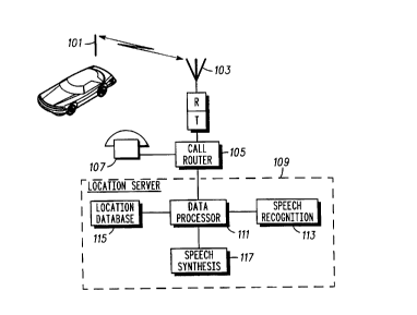
A block diagram of a communication system in accordance
5 with the present invention is shown in FIG. 1. A wireless
communication unit 101 transmits its user's request for service
to a wireless base station 103, also known as a repeater. The
wireless communication unit 101 may be a cellular telephone,
two-way radio with telephone interconnect capability, and so
10 forth. The base station 103 forwards the call to a call router
105, which routes the call to the location server 109
corresponding to the phone number dialed by the
communication unit 101. A user of a wireline communication
unit 107, such as a pay phone, a standard telephone, or
15 cordless telephone, may also dial the location server 109 to
receive its services.
The location server 109 is basically comprised of a data
processor 111, such as a POWER PC 603/66 microprocessor
20 available from Motorola, Inc. The processor has access to a
speech recognition module 113, which takes the digitized
speech that is transferred to the location server 109 and
converts the digitized speech into digital signals for use by the
data processor 111. Based on the information received from
25 the speech recognition module 113, the data processor 111
may ask the user of the communication unit 101 or 107 for
more information, by asking questions, to more specifically
determine either where the user is or what type of service the
user requests. Such questioning is provided through a speech
30 synthesis module 117, which takes stored questions and
converts them into voice transmissions that when transmitted
via communication ~h~nnels, become audible to the user after
demodulation by his/her communication unit 101 or 107. For
example, the commercially available "Software Developer's Kit
,
CA 022~916~ 1998-12-18
WO 97/50002 PCT/US97/03406
for Microprocessors," available from Learnout & Hauspie, can
both recognize and synthesize speech.
The data processor 111 also has access to a location database
115, from which the data processor 111 can try to match user
- information converted to digital information to stored location
information, such as addresses and landmark names. When a
match arises between the information from the user of the
communication unit 101 or 107 and information in the
database, the data processor 111 knows that it has located the
user or the user's requested location. The location database
115 includes for each geographic location a street address,
including numbers and street names or highway names and/or
numbers. Each geographic location also has a corresponding
landmark name. The landmark name includes, for example,
the name of a restaurant, a business, an airport, a historic place
of interest, a bus station, a train station, a building, and so
forth. Each location, in addition to having a street address and
a landmark name, has a corresponding grid reference. Each
area has a grid reference in terms of X and Y coordinates such
that correlations ma-y be provided between two different
geographic locations. These X and Y components may be, for
example, longitude and latitude components.
A flowchart describing location determination by a location
server 109 is shown in FIG. 2. At step 201, a voice
transmission with a verbal description of a location is received.
At step 203, using speech recognition techniques such as those
provided by the speech recognition module 113, the voice
transmission is converted into a data representation of the
location that was verbally described. At step 205, it is
determined if the location, in the format of a data
representation, is found in the location database 115. If the
location is in the database 115, the process continues with step
215. If the location is not in the database at step 205, the
CA 022~916~ 1998-12-18
WO 97/50002 PCT/US97/03406
process continues with step 207, where the location server
dialogs with the user of the communication unit 101 or 107 to
determine the location. FIG. 3 shows a method of providing a
dialogue technique. At step 209, it is determined if the location
5 from step 207 is found in the location database 115. If the
location is found at step 207, the process continues with step
215.
If the location is not found in the database at step 209, the
10 process continues with step 211. At step 211, the location is
determined using wireless transmission location techniques,
such as AVL (~utomatic Vehicle Location), GPS (Global
Positioning Satellite), and other such techniques as are known
in the art. See for example, U.S. Patent Application No.
15 08/XXX,XXX, titled "Method and Apparatus for Determining the
Location of a Wireless Communication System Subscriber," filed
on behalf of Eugene J. Bruckert et al. on June 12, 1996 with the
same assignee as the present application, which application is
incorporated herein by reference. At step 213, the location
20 server adaptively learns from the location determining step
211 by storing transmission parameters along with the
associated location. These tr~nsmission parameters include
signal strength, bit error rate, and signal delay spread.
25 The process then continues with step 215, where the
location database transmits, to the user, a request for a type of
service desired by the user. This request would be in the form
of a speech synthesized message that prompts for particular
answers from the user. The user may respond either verbally
30 by stating one of a selected number of choices, or by pressing a
- particular button or set of buttons on the telephone key pad.In the preferred embodiment, the types of service are location-
based services. For example, one type of service may be a
request for a street address of a particular location, where the
35 user knows the landmark name, but not the street address, but
CA 02259165 1998-12-18
WO 97/50002 PCT/US97/03406
- 10
can find the location from the street address. For example, the
user may wish to know the address for a particular restaurant,
but can find the restaurant once the address is known.
Another service may be a request for directions from a starting
5 location to a desired
CA 022~916~ 1998-12-18
WO 97/50002 PCT/US97/03406
location. Another type of service may be emergency dispatch
service, such as fire, police, or ambulance. In such a situation, a
person may be in a remote area, or may simply not know
where they are, but has a wireless communication unit such as
5 a cellular phone and needs an ambulance or other emergency
assistance dispatched to their location. Finally, the user may
request to speak to a live operator or other individual, to whom
the location server would route the call.
10 At step 219, the type of service and the location are
processed into information useful to the user. If a street
address was requested by the user, a street address is
provided to the user corresponding to the location provided by
the user at step 201. See FIG. 4 and its associated text for more
15 details. If, for example, the user requests directions from one
location to another location, the location server 109 will
provide directions from a starting location to a desired location.
In addition, road construction information may also be entered
into the database, such that when the directions are
20 determined by the location server 109 the directions may be
provided such that streets or highways currently under road
construction are avoided. Multiple sets of directions may be
provided under this method. See FIG. S and its associated text
for more details. If the user requested emergency assistance,
25 the user may be sent an estimated time of arrival, as sent to
the location server 109 after it requests the appropriate
assistance from the appropriate provider. See FIG. 6 and its
associated text for more details.
30 A flowchart showing a method of dialoging between a
location server 109 and a user with a communication unit 101
or 107 is shown in the flowchart of FIG. 3. At step 301, using
speech synthesis such as provided by the speech synthesis
module 117, a question is converted to a voice tr~nsmission
35 and tr~nsmitted to the user. Depending on the type of
.. . .. ...... .. . .
CA 022~916~ 1998-12-18
WO 97/50002 PCT/US97/03406
information sought by the location server 109, a series of
questions is stored in the location database 115, which
questions are designed to obtain the information needed by the
location server 109. At step 303, an answer to the question is
5 received by the location server. At step 305, the location
server 109 determines if the answer received at step 303
provides the information sought by the location server 109 to
properly determine the location. If a location is determined by
the answer at step 305, the process ends. If the location is not
10 yet determined, the process continues with step 307. If there
are more questions to be asked from the series of questions at
step 307, the process continues with step 301. If no more
questions are to be asked at step 307, the process ends without
a location being determined. The following example is a dialog
15 that may take place between a location server 109 and a user
of a communication unit 101.
LOCATION SERVER 109: "Good afternoon. Would you like
information about restaurants, hotels, gas stations, florists,
20 or do you require emergency service?"
USER: "I'd like the name of a nearby florist."
LOCATION SERVER 109: "Please tell me where you are now."
USER: "I'm at Fourth & Main."
LOCATION SERVER 109: "There are three florists nearby:
Able's, Baker's, and Charlie's. Charlie's is closest. Which one
30 do you prefer?"
USER: "Charlie's."
CA 022~916~ 1998-12-18
WO 97/50002 PCT/US97/03406
LOCATION SERVER 109: "Go east down Fourth Street for five
blocks. Charlie's Florist is at 132 Fourth Street. Do you need
any additional help?"
S USER "No."
LOCATION SERVER 109: "Thank you and good day."
A flowchart showing a method for determining a street
address is shown in the flowchart of FIG. 4. At step 401, a grid
reference is determined for the location provided by the user
at step 201. At step 403, a street address is determined from
the grid reference determined at step 401. This process
involves looking up the grid reference in the location database
115 and finding the corresponding street address from the
location database 115. At step 405, the street address is
converted into a voice transmission using the speech synthesis
module 117. At step 407, the voice tr~nsmission is transmitted
to the user, and the process ends.
A flowchart showing a method of determining directions
from a starting location to a desired location is shown in the
flowchart of FIG. 5. At step 501, a grid reference is determined
for the starting location, which is the location described at step
201. At step 503, a grid reference is determined for the
desired location, which is requested from the user. At step
505, using a stored map, directions are determined from the
starting location to the desired location using the differences
between the grid references. For example, the commercially
available Tripmaker 1996 Edition CDROM from Rand McNally &
Company provides a drive route given a source and destination
address. At step 507, the directions are converted into a voice
transmission using the speech synthesis module 117. At step
509, the voice transmission is transmitted to the user, and the
process ends.
CA 022~916~ 1998-12-18
WO 97/50002 PCT/US97/03406
14
A flowchart describing a method of handling a request for
emergency assistance is shown in the flowchart of FIG. 6. At
step 601, the type of emergency assistance requested is
5 determined, for example, by using the steps of the flowchart of
FIG. 3, until the particular type of emergency assistance
required is determined. At step 603, a provider of the type of
emergency assistance is determined from a look-up table in the
location database 1 15. The location database 115 has stored
10 phone numbers, provider locations, and other relevant
information necessary to assist the location server 109 in
requesting emergency information. For example, if the user
requests that an ambulance be sent, the location server will
look under ambulance in the location database 115 and find a
15 provider of an ambulance that is close in location to the present
location of the user. At step 605, a message to the provider is
transmitted, wherein the message requests the type of
emergency assistance the user requested at the location of the
user. At step 607, the location server 109 receives an
20 estimated time of arrival of the emergency assistance from the
provider. At step 609, the location server 109 transmits to the
user the estimated time of arrival of the
CA 022~916~ 1998-12-18
W O 97/50002 PCTrUS97/03406
emergency assistance, and the process ends. The following
example is a dialog that may take place between a location
server 109 and a user of a communication unit 101.
5 LOCATION SERVER 109: "Good afternoon. Would you like
information about restaurants, hotels, gas stations, florists,
or do you require emergency service?"
USER: "I need emergency service."
LOCATION SERVER 109: "Do you need the police, an
ambulance, fire department, or roadside service?"
USER: "Police."
LOCATION SERVER 109: "Connecting; a police vehicle will be
at your location within 60 seconds ... Thank you and good
bye."
20 The present invention provides the following advantages.
There is no longer a need to have extra locating equipment in
the master switches or base stations. If there is location
equipment in base stations, the subscriber provides much
higher accuracy. No route pl~nning equipment is needed in the
25 master switch. The present invention provides easy addition
or modification of services supplied because the server is
centralized in location. Wireless users are provided with
location information and other services that were previously
limited to automobiles and wireline users. The use of the RF
30 location equipment helps narrow the scope of possible items
for processing by the voice recognizer. Correlating subscriber-
provided location information with the RF location information
helps to better predict and analyze wireless communication
system coverage, thereby providing a mec~h~ni~sm to learn RF
35 coverage as the wireless communication system is used.
.