Note: Descriptions are shown in the official language in which they were submitted.
CA 02266208 1999-03-19
REMOTE ROAD TRAFFIC DATA EXCHANGE
AND INTELLIGENT VEHICLE HIGHWAY SYSTEM
TECHNICAL FIELD
This invention relates to a traffic data
exchange and intelligent vehicle highway system and, in
particular, to a system and method for remotely
collecting dynamic traffic data using global positioning
systems to provide real-time traffic forecast and travel
guidance for drivers.
BACKGROUND OF THE INVENTION
Modern automobile travel has long been plagued
by excessive traffic congestion and resulting air
pollution from continuously increasing automobile use.
Drivers have long sought optimum travel routes to
minimize driving time. Local area radio and television
stations have transmitted "SIG-ALERTS" to inform drivers
of blocked or congested traffic routes so that drivers
familiar with various routes to their respective
destinations can alter and reroute their planned route to
minimize driving time which is often unproductive and
represents an aggregate burden on society. Such
"SIG-ALERTS" disadvantageously require real-time
- 1 -
CA 02266208 1999-03-19
receptions by the drivers prior to entering the congested
traffic area. Such "SIG-ALERTS" are often missed when
drivers are not tuned into the transmitting station at
the proper time. Moreover, drivers tend to learn and
routinely follow the same route day after day without
becoming familiar with alternate routes even in the face
of heavy recurring congestion. Roadside signs have also
long been used to warn drivers and re-direct traffic
during road construction or traffic congestion. For
example, posted detour signs and electronic roadside
billboards have been used to suggest or require
alternative routes. Some electronic billboards have been
posted on main traffic arteries, warning of a pending
traffic blockage or congestion. However, these signs and
billboards also suffer from being posted too near to the
point of congestion or blockage preventing meaningful
re-evaluation of the planned route or an alternate route,
primarily because of the required close proximal
relationship between the sign location and the point of
congestion or blockage. There exists a continuing need
to improve the reception of accurate traffic congestion
and alternate routing information.
Governmental agencies have provided emergency
care service in response to roadside vehicle accidents,
2 -
CA 02266208 1999-03-19
as is well known. Governmental agencies have adopted the
well-known 911 emergency call method through which road
accidents are reported and followed by the dispatching of
the emergency care services including police, fire and
paramedic services using dedicated emergency RF radio
systems. Such RF radio systems and methods often require
the reporting of the accident by private citizens who are
typically either witnesses of the accident or are
involved in the accident. However, such systems and
methods fail when such victims are decapitated by injury
or when such witnesses are unable to quickly locate an
operating phone especially in remote areas. Moreover,
critical time is often lost when searching for a
telephone to place the 911 call on a remote telephone.
Further still, misinformation may be inadvertently given
by those reporting victims and witnesses unfamiliar with
the location of the accident, thereby directing the
emergency care provider to the wrong location. There
exists a continuing need to more expeditiously provide
accurate vehicle traffic accident information to
emergency care providers.
Automobiles have also been adapted with
experimental local area road-map systems which display a
map portion of interest with no global positioning system
- 3 -
CA 02266208 1999-03-19
(GPS) information. The driver can locate departure and
destination points on the map, and then visually follow
the displayed map respecting the current position of the
vehicle, as the driver travels toward the desired
destination point. The map system displays a cursor to
locate the current position of the moving vehicle on the
display map. The portion of the map that is displayed is
periodically adjusted to keep the current position cursor
in the centre of the displayed map portion. The map
systems use a compass and a wheel sensor odometer to move
the current position from one location to another as the
vehicle travels on the road. The use of such map display
systems require the driver to repetitively study the map
and then mentally and repetitively determine and select
travel routes devoting attention away from the safe
operation of the vehicle. The display of the map with a
current position cursor tends to increase traffic
accidents, rather than promote safe operation. Also, the
compass and wheel odometer technology causes map position
error drifts over distance, requiring re-calibration
after travelling only a few miles. Moreover, the use of
such a map system disadvantageously requires the entry of
the departure point each time the driver begins a new
route.
4 -
CA 02266208 1999-03-19
Additionally, the map system does not perform
route guidance including a route through which the driver
should take to reach a particular destination point. The
map system is not dynamically updated with current
traffic information, such as detours for road
construction, blocked routes due to accidents and delayed
travel times due to heavy traffic congestion. There
exists a continuing need to improve map systems with a
driver friendly interface which reduces diversion away
from the safe attentive operation of the vehicle to
promote accident free dynamic route guidance vehicle
operation.
Certain experimental integrated vehicle dynamic
guidance systems have been proposed. For example,
Motorola has disclosed an intelligent vehicle highway
system in block diagram form in copyright dated in a 1993
brochure, and DELCO Electronics has disclosed another
intelligent vehicle highway system also in block diagram
form in Automotive News published on April 12, 1993.
These systems use compass technology for vehicle
positioning. However, displacement wheel sensors are
plagued by tire slippage, tire wear and are relatively
inaccurate, requiring re-calibration of the current
position. Compasses suffer from drafting particularly
- 5 -
CA 02266208 1999-03-19
when driving on a straight road for an extended period.
These intelligent vehicle highway systems appear to use
global positioning systems (GPS) satellite reception to
enhance vehicle tracking on road-maps as part of a
guidance and control system. These systems use GPS to
determine when draft errors become excessive and to
indicate that re-calibration is necessary. However, the
GPS reception is not used for automatic accurate
re-calibration of current vehicle positioning.
These intelligent vehicle highway systems also
use RF receivers to receive dynamic road condition
information for dynamic route guidance, and contemplate
infrastructure traffic monitoring, for example, a network
for road magnetic sensing loops, and contemplate the RF
broadcasting of dynamic traffic conditions for dynamic
route guidance. The disclosed two-way RF communication
through the use of a transceiver suggests a dedicated
two-way RF radio data system. While two-way RF
communication is possible, the flow of necessary
information between the vehicles and central systems
appears to be exceedingly lopsided. It seems that the
amount of the broadcasted dynamic traffic flow
information from a central traffic radio data control
system to the vehicles would be far greater than the
6 -
CA 02266208 1999-03-19
information transmitted from the vehicles to the central
traffic control centre. For example, roadside incidents
or accident emergency messages to a central system may
occur far less than the occurrences of congested traffic
points on a road map having a large number of road
coordinate points.
To overcome the above disadvantages and to meet
the existing needs, United States Patent No. 5,504,482,
entitled AUTOMOBILE NAVIGATION GUIDANCE, CONTROL AND
SAFETY SYSTEM issued to K.D. Schreder on April 2, 1996,
discloses an automobile route guidance system. In this
system, an automobile is equipped with an inertial
measuring unit and GPS satellite navigational unit and a
local area digitized street map system for precise
electronic positioning and route guidance between
departures and arrivals, is equipped with RF receivers to
monitor updated traffic condition information for dynamic
re-routing guidance with a resulting reduction in travel
time, traffic congestion and pollution emissions, is also
equipped with vehicle superseding controls substantially
activated during unstable vehicle conditions sensed by
the inertial measuring unit to improve the safe operation
of the automobile so as to reduce vehicle accidents, and
is further equipped with telecommunications through which
7 -
CA 02266208 1999-03-19
emergency care providers are automatically notified of
the precise location of the automobile in the case of an
accident so as to improve the response time of roadside
emergency care.
Nevertheless, Schreder fails to address, in
this United States patent, how the traffic data is
collected for broadcasting the road traffic condition on
which the system is based to provide the navigation
guidance. Another disadvantage of the system relates to
correction of the positioning error on the road map. A
map-matching smoothing process is disclosed by Schreder,
which adjusts the display output so that the vehicle is
displayed exactly on a road rather than elsewhere based
upon the errors of the navigation positioning and road
map. The process does the adjustment in a manner in
which the cursor representing the current position of the
vehicle is simply moved to the nearest available map road
position. This may cause a mistaken position on a wrong
road, particularly in the case where more than one road
are about equally close to the cursor.
There are several basic techniques for
collecting traffic data. In the most common, different
sensing systems are used to collect traffic volume and
vehicle speed. Sensors for counting purposes are
- 8 -
CA 02266208 1999-03-19
installed along highways to count traffic volume. Video
cameras, color machine vision technology and pulsed laser
range imaging technology are used to generate advanced
traffic parameters such as driving speed and travel time.
These technologies are disclosed, for example, in United
States Patent No. 5,546,188, entitled INTELLIGENT VEHICLE
HIGHWAY SYSTEM SENSOR AND METHOD and issued to Wangler
et al. on August 13, 1996. In other applications,
multifunctional roadway reference systems are suggested,
in which either discrete marks installed in the centre of
a traffic lane code one or more bits of information, such
as geographical position, upcoming road geometry and the
like. An example of roadway reference systems is
disclosed in United States Patent No. 5,347,456 which is
entitled INTELLIGENT ROADWAY REFERENCE SYSTEM FOR VEHICLE
LATERAL GUIDANCE AND CONTROL. This patent issued to
Zhang et al. on September 13, 1994.
Given the size of a continent highway system,
using sensor and/or cameras to collect road traffic data
for each and every public road in a continent is
extremely expensive, inconvenient and impractical. With
these technical considerations and the system costs in
mind, techniques for collecting dynamic traffic data
using equipment installed in vehicles have to be
9 -
CA 02266208 1999-03-19
developed. Furthermore, in the prior art there does not
exist a general road network traffic forecast system for
broadcasting road traffic forecasts available for drivers
to plan a trip in advance. An improved remote road
traffic data collection and traffic forecast system is
desirable.
SUMMARY OF THE INVENTION
An object of the invention is to provide a
remote traffic data collection and intelligent vehicle
highway system.
Another object of the invention is to provide a
road network traffic forecasting system.
Yet another object of the invention is to
provide drivers of automobiles with a route guidance
system.
Yet another object of the invention is to
provide a route guidance system which uses information
from a global positioning system (GPS) and accurately
positions a vehicle within a digitized road network.
Still another object of the invention is to
provide a route guidance system which computes optimum
routes between departure and destination points based on
10 -
CA 02266208 1999-03-19
road traffic forecast and updated current road condition
information.
A further object of the invention is to provide
an economical system for remote collection of road
traffic data in a wide area for road traffic forecasts.
Yet a further object of the invention is to
provide a system which exchanges road traffic forecast
information and road traffic data between a traffic
service center and moving vehicles.
In general terms, a remote road traffic data
exchange and intelligent vehicle highway system comprises
a road traffic data collection sub-system, a
communication sub-system, a traffic service centre that
stores and processes road traffic information and
provides real-time road traffic forecast for drivers, and
a route guidance sub-system. The road traffic data
collection sub-system and the route guidance sub-system
are incorporated into in-vehicle equipments installed in
a plurality of vehicles. The road traffic data
collection sub-system uses geographic position
information received from a global position system (GPS)
to locate the vehicle on a digitized road network and a
communication system sends the vehicle position data to
the traffic service centre to be processed for the road
- 11 -
CA 02266208 1999-03-19
traffic forecasts. The road traffic forecast is based on
a time period of weeks. The road traffic data collected
in a given time on a given day of a week for a specific
road segment is processed so that an average travel time
or speed for this road segment at the given time on the
given day of the week is determined and is used to
forecast the travel time or speed in normal road
conditions for this road segment at the same time on the
same day of a future week.
Road traffic varies from time to time in a day
or in a week. However, in a normal condition that is not
affected by any abnormal situation, such as traffic
accidents, road construction, bad weather, holidays or
public activities, a road traffic pattern of one week is
similar to that of another week. This fact provides a
base for road traffic forecasts in a normal condition.
The road traffic forecast will be more practical when it
is adjusted by factors associated with specific abnormal
situations that occur at a time the forecast is made.
The method of accurately locating a vehicle on
the digitized road network that is formed with nodes and
the links between the nodes comprises obtaining a
geographic position of a vehicle and moving the
geographic position point to a near link in accordance
12 -
CA 02266208 1999-03-19
with information associated with a node as a last known
node which the vehicle last passed to avoid moving the
geographical position point to a wrong road.
In specific terms, in accordance with one
aspect of the invention, there is provided a method for
forecasting road traffic comprising the steps of: (a)
collecting at a traffic service center from time to time
dynamic vehicle position data reported by vehicles
travelling roads, the vehicles being adapted to receive
geographic position data thereof from a global
positioning system (GPS) and to convert the geographic
position data into relative position data associated with
a digitised road network represented as nodes and links
between the nodes, the relative position data comprising
the dynamic vehicle position data to be reported; (b)
computing real travel times of vehicles travelling each
of the links using information from the dynamic vehicle
position data; (c) determining a set of real travel time
samples for a link Ll from travel times of vehicles that
travel the link Ll within a given time interval starting
at a time instance t on a given day D of a week; (d)
calculating an average travel time Tl for the link Ll
using the set of travel time samples for predicting
13 -
CA 02266208 1999-03-19
travel time for the link Li at the time instance t on the
day D of a future week.
Preferably, the method further comprising steps
of repeating steps of (c) and (d) to calculate an average
travel time T2 for a link L2 at a time instance (t + T1),
an average travel time T3 for a link L3 at a time
instance (t + Ti + T2) and up to an average travel time
Tn for a link Ln at a time instance (t + Tl + T2 +
... + Tn-i); calculating an average travel time TR of a
route R including continuous links Ll, L2, L3, ... and Ln
at the departure time t by summing up the average travel
times T1, T2, T3, ... and Tn for predicting a travel time
for route R at the departure time t on the day D of the
future week.
In accordance with another aspect of the
invention, a remote traffic data exchange and intelligent
vehicle highway system is provided. The system comprises
a remote traffic data collection sub-system including a
plurality of in-vehicle equipped devices, each of the
devices being adapted to receive from time to time
geographic position data of the vehicle from a Global
Positioning System (GPS) and to convert the geographic
position data into dynamic vehicle position data
- 14 -
CA 02266208 1999-03-19
associated with a digitized road network represented as
nodes and links between the nodes;
a traffic service center adapted for processing
the dynamic vehicle position data and determining an
average travel time or speed for a specific link at a
time instance on a day of a week and forecasting the
average travel time or speed for the same link at the
same time instance on the same day of a future week; and
a communication sub-system for exchanging the
road traffic data and the road traffic forecast between
the vehicles and the traffic service center.
The system provides a practical and economic
solution for building such an intelligent vehicle highway
system in a wide area and providing a general and
complete traffic forecast for the public.
BRIEF DESCRIPTION OF THE DRAWINGS
The invention is further disclosed in details
of a preferred embodiment by way of example only with
reference to the accompanying drawings, in which:
FIG. 1 is a schematic view of a configuration
of the preferred embodiment of the invention;
- 15 -
CA 02266208 1999-03-19
FIG. 2 is a schematic diagram showing a
configuration of an in-vehicle equipped device used in
the embodiment of FIG. 1;
FIG. 3 is a schematic diagram showing a
configuration of the traffic service center;
FIG. 4 is a schematic view of a roadway system;
FIG. 5 is a schematic view of a digitized road
network representing the roadway system of FIG. 4;
FIG. 6 is a diagram showing a link slope angle;
FIG. 7 is a diagram showing a method of
locating a vehicle position onto the digitized road
network of FIG. 5.
FIG. 8 is a diagram showing a method for
locating a position to a node; and
FIG. 9 is a diagram showing a data collecting
and reporting sequence.
DETAILED DESCRIPTION OF THE PREFERRED EMBODIMENT
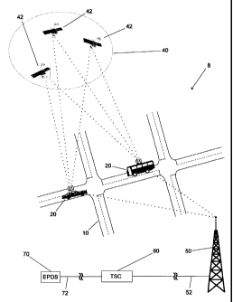
In FIG. 1, a traffic data remote exchange and
intelligent vehicle highway system generally indicated by
reference numeral 8, is illustrated. A group of
vehicles 20 travel in a roadway system 10, which may be a
metropolitan highway system, a regional highway system,
national expressway system or a cross-continent
16 -
CA 02266208 1999-03-19
expressway system. Each vehicle 20 is installed with an
in-vehicle equipped device 21 which receives dynamic
geographical position data of the vehicle from
satellites 42 of a Global Positioning System (GPS) 40.
The in-vehicle equipped device 21 converts the geographic
position data into dynamic positions of the vehicle
relating to a digitized road network that represents the
roadway system in which the vehicle is travelling. The
digitized road network must be provided with a reference
system (latitude and longitude) consistent with the
reference system used by the GPS 40. The in-vehicle
equipped device 21 sends the dynamic road positions of
the vehicle in radio frequency data to a communication
station 50 and the communication station 50 in turn sends
the dynamic positions of the vehicle through cable
connection 52 to a traffic service centre 60. The
traffic service centre 60 is also connected through
cables or telephone lines 72 to External Party Data
Sources (EPDS) 70 which may include information
departments of police stations, the 911 service centre
and government agencies such as weather departments,
highway and traffic administration departments. The
traffic service centre 60 uses the dynamic road positions
of all vehicles 20 and the information obtained from the
17 -
CA 02266208 1999-03-19
external party data sources to provide the real-time road
traffic forecasts for the roadway system 10 and broadcast
the road traffic forecasts via the communication station.
The in-vehicle equipped device 21 on each vehicle 20
receives the road traffic forecasts from the broadcast
and processes information included in the road traffic
forecasts, providing route guidance to the driver,
recommending a real-time optimum travel route based on
the real-time road traffic forecasts.
The in-vehicle equipped device 21, as
illustrated in FIG. 2, includes a GPS receiver 22 and
receives positioning signals from a constellation of
satellites 42 in orbit above the earth, which forms the
global positioning system 40. The GPS receiver 22
locates the vehicle on earth, providing a geographic
position of the vehicle.
Global positioning system technology plays a
critical role in this invention. GPS consists of 24
satellites orbiting the earth, each satellite emitting
timing positioning signals. The GPS satellites 42 are
arranged so that there are always more than three
satellites in the field of view of any pertinent place on
the earth. The precise position of a point can be
determined by measuring the time required for the
18 -
CA 02266208 1999-03-19
positioning signals of at least three satellites to reach
that point. The GPS satellites 42 transmit timing
positioning signals to the GPS receivers 22 installed in
the vehicles 20. Each receiver 22 interprets the signals
from three or more satellites 42 and determines a
geographic position in accuracy within an average of 20
metres, which is considered to be a positioning error.
Differential GPS systems may provide even greater
accuracy using geographic benchmark correction.
The existence of this error means that a
geographical position of a vehicle moving on a road
determined by the GPS signals may be located, for
example, in a ditch or even on the top of a roadside
building. To correct this error, a method of converting
this geographical position to a location on a
corresponding roadmap, particularly on a digitized road
network is developed and will be disclosed below.
A vehicle supporting sub-system 30 is provided
in the in-vehicle equipped device 21 and includes a road
network locator 32 and a road explorer 34. A mobile
radio sub-system 24 is provided for exchanging
information in radio frequency data with the traffic
service centre 60 via the communication station 50. Also
included in the in-vehicle equipped device 21 are a
19 -
CA 02266208 1999-03-19
computer system 26 for running the road network locator
32 and road explorer 34 as well as storing a digitized
road network and temporarily storing data for processing,
and a driver interface 28 that includes a microphone,
data entry pad, screen display and loud-speaker for the
drivers to interact with the system 8.
The road network locator 32 places the
geographic position of the vehicle, determined by the GSP
receiver 22, onto the digitized road network which is
broadcasted from the traffic service center 60 via the
communication station 50 and is stored in the computer
system 26, and moves the geographic position of the
vehicle to a relevant road segment using a novel method
in accordance with the invention to correct positioning
errors. From time to time, the mobile radio sub-system
24 transmits the road traffic data processed by the road
network locator 32 in radio frequencies to the
communication station 50 which sends road traffic data
reported from all vehicles 20 travelling in the roadway
system 10 to the traffic service centre 60 to be further
processed for forecasting the road traffic conditions at
a future time. The mobile radio system 24 in the vehicle
20 also receives radio frequency data broadcasted by the
communication station 50, the broadcasted data including
20 -
CA 02266208 1999-03-19
the digitized road network and the road traffic
forecasts. The data received by the mobile radio sub-
system 24 is temporarily stored in the computer system 26
and the road network explorer 34 uses the data in the
computer system 26 and driver's instructions received
from the drivers interface 28 to make an intelligent
decision for route guidance. The intelligent decision on
route guidance such as an optimum travel route based on
the real-time road traffic forecast is displayed on the
screen display of the driver interface 28.
For the purpose of location report and route
guidance, the digital road network used includes only
intersections and road segments with indicated traffic
directions. The size of a digitized road network is
positively proportional to the population of the area.
For an area, for example, with a population around one
million, its road network is about 10,000 intersections
and 40,000 road segments in one-way traffic direction.
It is assumed that 20 bytes is needed for an intersection
or a road segment in one-way traffic direction.
Therefore, one megabyte is needed to digitize the road
network of the area. It is not necessary to keep the
whole continent roadway system in vehicles since
metropolitan areas are separated from one another and are
21 -
CA 02266208 1999-03-19
connected by the continent expressway system. The
digitized road network may be broadcasted on a regional
basis and each vehicle keeps only two digitized road
networks at any time. One is the continent expressway
network and the other a local regional/metropolitan
roadway network. When a vehicle travels from one region
to another, it gets away from its previous roadway
network, and moves around on the continent expressway
network. Meanwhile, it receives a new roadway network of
the upcoming region.
FIG. 3 illustrates the configuration of the
traffic service centre 60. A data exchange interface 62
is provided for connection of the communication
station 50 through the cable 52 for receiving the
collected road traffic data and sending the data
respecting the digitized road network and real-time road
traffic forecast which are to be broadcasted. An
external party interface 64 is also provided to connect
the external party data source 70 for receiving the real-
time information about weather or road conditions which
is processed by an external party data integrator 65 to
be incorporated into a real-time road traffic forecast.
The real-time road traffic forecast is completed by a
traffic forecaster 68 using the collected road traffic
- 22 -
CA 02266208 1999-03-19
data for a normal road condition. The collected road
traffic data received from the data exchange interface 62
is stored in a database 66 to be processed by the traffic
forecaster 68. A TSC server 67 is also provided for
running the traffic forecaster 68 as well as storing the
digitized road network and temporarily storing the real-
time road traffic forecast. An operator interface 69
including a microphone, loud-speaker, data entry pad and
screen display permits an operator to interact with the
system 8.
The roadway system 10 is illustrated in FIG. 4,
presented as a road map for travellers. In the roadway
system 10, each road is indicated by reference
numeral 11. Generally, each road 11 is a two-way traffic
road permitting vehicles to travel in opposite
directions. Each one-way road marked by arrows 12
indicates the traffic direction allowed on this road. As
discussed above, the roadway system 10 has to be
digitized and include only intersections and road
segments oriented in the traffic direction to be kept at
an adequate data size to be broadcasted and stored in the
computer system 26 of in-vehicle equipped device 21. A
digitized road network 13 representing the roadway system
10 of FIG. 4 is illustrated in FIG. 5. The digitized
- 23 -
CA 02266208 1999-03-19
road network 13 is an abstract representation of a
roadway system which includes intersections, road
segments, parking lots, ramps, bridges, overpasses,
tunnels, highways and special points. Although there are
many physical elements in a roadway system, there are
only two classes of elements represented in the digital
road network 13: nodes 14 and links 16 oriented in the
traffic direction. The node 14 may present an
intersection of two or more roads, an entry of a parking
lot, a junction of a highway and an entry or exit ramp, a
starting or an endpoint of a bridge, a tunnel, an
overpass and an arbitrary location on a road. A link 16
represents a road segment with an orientation, which
connects two nodes 14 of the road network. A node from
which a link exits is called a source node of the link
and a node towards which a link is orientated is called a
sink node. Further, the link is said to be an outgoing
link of the source node and an incoming link of the sink
node.
When a road segment allows only one-way
traffic, this road segment may be represented by one link
with an orientation which is the same as the traffic
direction on the road segment. When a road segment
allows two-way traffic, this road segment may be
- 24 -
CA 02266208 1999-03-19
represented by two links with opposite orientations to
each other.
A road segment may be either straight or
curved. In the digitized road network representation,
however, all links are treated as straight. Therefore,
necessary adjustments have to be done to make the
digitized road network representation more meaningful.
When a road segment is curved, some arbitrary nodes may
be placed somewhere on the segment to create several
shorter segments so that each shorter segment is treated
as straight. Criteria may be set up for determining what
curves are considered to be treated as straight. One
criterion, for example, is suggested as follows: a
straight line is created to connect the two end points of
a curve C and the curve C is treated as straight if Ls/Lc
is sufficiently close to 1, wherein Lc is the length of
the curve C and Ls is the length of the straight line. A
predetermined parameter o.97, for example, may be given.
If o.97 < Ls/Lc < 1, the curve C is treated as straight.
In FIG. 6, a unique character, the slope angle
of each link is illustrated. A link 16 has a source
node NA and a sink node NB in the digitized road
network 13. An arbitrary link 15 is placed on the
digitized road network, outgoing from the source node NA
-
CA 02266208 1999-03-19
horizontally towards the right, representing due east
orientation. The slope angle alpha of the link 16 is
defined by computing the angle of rotation between the
link 16 and the arbitrary link 15. The slope angle alpha
of the link 16 is between + 1800, being represented as a
positive angle if the link 16 is in an up quadrant with
respect to the arbitrary link 15 and as a negative angle
if the link 16 is in a lower quadrant. The unique
character of the sloping angle of each link provides a
base for correcting the errors in locating a geographic
position onto the digitized road network. The method of
locating a geographic position onto the digitized road
network is disclosed below.
In FIG. 7, node 14 represents an intersection
of four roads that are represented by links 16 and marked
with Al to A4, individually. Point P represents a
current geographic position determined from the GPS
information and the node 14 is a last known node that the
vehicle last passed and is determined by previous steps
of the locating process. A position link 17 is
additionally made from the last known node 14 to the
current position P. Slope angles of the position link 17
and each of links Al to A4 are calculated using the
method described in the last paragraph. In this example,
26 -
CA 02266208 1999-03-19
the slope angle of a position link 17 is beta, the slope
angles of links Al to A4 are 0 , 90 , 180 and -90 ,
respectively. One of the links Al to A4 is selected as a
nearest link to the current geographic position P when
the difference is smallest between the absolute values of
the slope angles of the selected link and the position
link 17. In this case, link Al is selected. A last step
of the method is to move the current geographic
position P to point Q on the selected link Al and
maintain a length between node 14 and point Q equal to
the length between the node 14 and the point P. In this
method, the adjustment of a vehicle position on the
digitized road network is always associated with a last
known node information and a mistake to locate the
geographical position to a wrong road is avoided. This
advantage will be clearer in a further description of the
process of remote traffic data collection.
A process for remotely collecting traffic flow
speed and travel time using the remote traffic data
exchange and intelligent vehicle highway system 8 is
disclosed in detail below.
Each vehicle 20 equipped with the GPS
receiver 21 aligned to receive positioning signals from
the selected constellation of satellites 42 receives the
- 27 -
CA 02266208 1999-03-19
positioning signals and uses the information included in
the positioning signals to determine a vehicle's
geographical position. Before the geographical position
is to be located on the digitized road network 13 which
is received by the mobile radio sub-system 24 in radio
frequency broadcast data and stored in the computer
system 26, a start point of the vehicles dynamic
positions has to be determined because a last known node
has to be provided for further locating a current
geographic position onto the digitized road network 13.
The road network locator 32 places a first geographic
position to the digitized road network and compares the
distance between the current geographic position and a
nearest node with a predetermined small length. The road
network locator 32 moves the current geographical
position to the nearest node as a start point to be used
as a last known node in the following process steps when
the distance is smaller than the predetermined length.
The road network locator 32 drops the current
geographical position when the distance is greater than
the predetermined length, and repeats the above steps
using a following geographic position until the distance
between a new geographical position and a nearest node is
smaller than the predetermined length. The newly
28 -
CA 02266208 1999-03-19
determined nearest node is a start point and is to be
used as a last known node for the following process
steps. The predetermined length is used to control the
accuracy of the positioning process. An example is
illustrated in FIG. 8, in which points Cl to C9 on
links 16 represent the individual geographical positions
related to a time instance sequence at which the
geographical position data is collected. The first
geographical position Cl has a distance from the nearest
node Ni and the distance is greater than a predetermined
length dl and therefore the Ci is dropped. Similarly, C2
and C3 are dropped. However, the fourth geographic
position C4 is within the predetermined distance dl from
a nearest node N2 and the C4 is moved to the node N2 that
serves as a start point to be used as a last known node
in further locating processing steps. After the start
point is determined, the road network locator 32 uses a
method illustrated in FIG. 7 to locate the dynamic
geographic positions to the links 16 in the digitized
road network 13 if these geographic positions are not on
the links 16.
However, the start point is not necessary to be
located at the beginning of each trip. It is recommended
that in-vehicle equipped devices 21 are kept on to
29 -
CA 02266208 1999-03-19
continue receiving the real-time traffic forecasts when
the vehicles complete their last trip and are parked.
The reason for doing that is to let drivers have the real
time traffic forecasts and the route guidance services
right away when they start their trips and do not need to
wait a short period of time to receive all data
respecting the local roadway system. Therefore, the
standby status of the in-vehicle equipped devices 21
keeps the last known node data of the previous trip and
this last known node is usually a start point of the same
vehicles for a following trip. There are a few
exceptions. For example, the vehicle drives into one
entry of an underground garage and exits from an exit
that is different from the original entry and may be
located on another street. In these exceptional cases, a
start point has to be determined by the method disclosed
above.
Generally, the geographical positions of the
vehicle located on the links are not always matched with
nodes. In a digitized road network, there are only two
classes of elements: links and nodes, and the
information associated with each node is more important
and useful. An adjustment is necessary to ensure that
traffic information on each node is collected. An
-
CA 02266208 1999-03-19
example is illustrated in FIG. 8. C5 to C9 are dynamic
geographic positions and are correctly located on the
links 16. A predetermined small length d2 is compared
with the distance between each of the positions C5 to C9
and a nearest node 14. A position remains on the link 16
in its original place if the distance is greater than the
predetermined length d2, as C5 to C8 is this case. A
position, however, is moved to a nearest node if the
distance is smaller than the predetermined length d2, in
which case, the position C9 is moved to node N3.
Therefore, the position information related to C9 is now
associated with node N3. In a general situation, a
proper data collecting interval which is to be further
discussed below, and an adequately predetermined d2
ensure that more than one position should be located on
each link and most nodes should be provided with traffic
data after the adjustment is done.
The collected data respecting the vehicle's
positions is not reported to the traffic service
centre 60 at each collection and is temporarily stored in
the computer system 26 of the in-vehicle equipped
device 21 to be sent in groups later. A time interval CI
in seconds known as Collecting Interval and a time
interval RI in seconds known as Reporting Interval are
31 -
CA 02266208 1999-03-19
predetermined. An example of a traffic data collecting
and reporting sequence is illustrated in FIG. 9. Within
a period of time, the dynamic positions of a vehicle 20
located in the digitized road network 13 are points C10
to C20 and the time interval from one position to the
next one is CI. The CI is a predetermined constant time
interval to collect the dynamic position status, and the
distance between two adjacent positions may not be
constant because the travel speed of the vehicle may
change. The predetermined time interval RI for reporting
the dynamic position data to the traffic service
centre 60 are two times of CI, that is, the vehicle
reports a group of dynamic position data including a last
position and a current position at every second data
collection. Practically, one RI may include more CIs,
for example, 5 CIs and each report includes more position
data so that the transmission of data from the vehicle 20
to the traffic service centre 60 is much more efficient
than data transmission at each collecting time.
Furthermore, for a digitized road network, only the
information associated with nodes is important. The
position data reported from each vehicle 20 to the
traffic service centre 60 may only include the position
data relating to nodes 14. In this example, the first
- 32 -
CA 02266208 1999-03-19
report includes position C10 that relates to node Nil and
the second group of position data includes C11 and C12
which does not relate to a node, and is not reported.
The third group of positions includes C13, C14 and only
C13 relates to node N12. The position C13 is reported in
this reporting pattern. The positions C16, C18 and C20
which relate to node N13, N14 and N15 respectively are
reported and the rest of the positions are not reported.
Therefore, the volume of the data transmitted is
decreased significantly and, of course, the traffic
service centre 60 stores and processes much less data.
It is a simple calculation for the traffic
forecaster 68 of the traffic service centre 60 to
determine the travel time of a vehicle for a specific
link or the vehicle travel speed on that link. The
traffic forecaster 68 retrieves traffic data of two
adjacent nodes from the database 66 and determines a time
the vehicle was on the source node of the link and
another time the vehicle was on the sink node of the
link. The travel time of the vehicle for this link is
further determined by calculating the difference of the
two times. The vehicle travel speed for this link is
determined by dividing the length of the link by the
travel time of the vehicle. The data including the
- 33 -
CA 02266208 1999-03-19
travel time of each link or vehicle travel speed on each
link are collected from time to time from every
vehicle 20 of the group travelling around in the roadway
system 10, and provide a database to forecast the road
traffic conditions for the roadway system 10.
The road traffic forecast is based generally on
the fact that in a normal condition, road traffic varies
from time to time in one week but it does not change too
much from one week to the next if no abnormal situations
occur, such as traffic accidents, bad weather, road
constructions, holidays or special public activities.
Therefore, an average traffic condition for a specific
link or route which is formed by continuous links, at a
given time on a given day of a week may be used as a
basic traffic condition for this link or route in a
normal situation at the same time on the same day of a
future week. The average traffic condition is further
adjusted by special factors associated with any abnormal
condition occurrences at the time the real-time road
traffic forecast is made. The method for forecasting the
travel time for a link or a route at a time instance t on
a given day D of a week is disclosed in detail with
reference to the following example.
- 34 -
CA 02266208 1999-03-19
The traffic forecaster 68 retrieves from the
database 66 time-varied vehicle locations and computing
link travel times of the vehicles. The day is divided
into predetermined equal time intervals as a Forecast
Interval (FI) which should be a factor 60, for example,
5 minutes. One of the time intervals is determined to
contain the given time instance t, for example, the time
interval from 3:00pm to 3:05pm that contains the given
time instance 3:00pm of a given day, for example, Monday.
A set of travel time samples for a link L at the time
interval from 3:00pm to 3:05pm on Monday of the week is
selected and an average travel time for the link L within
the time interval 3:00pm to 3:05pm on Monday of the week
is determined by summing up all travel times of the
samples and being further divided by the number of
samples. This is the predicted travel time for the
link L at time instance 3:00pm on Monday of the next
week. The week in which the traffic data is collected
and processed in the above-described method for
predicting the traffic conditions in a future week is
referred to as a "historic period". However, because of
abnormal conditions which occur in the historic period,
the average travel time for the link at the time instance
may not really represent a normal, average traffic
- 35 -
CA 02266208 1999-03-19
condition. For example, a traffic accident occurs on the
link L at 2:45pm on Monday and the traffic on the link L
between 3:00pm and 3:05pm is affected. Therefore, the
average travel time for the link L within that time
interval does not represent a normal traffic condition at
this time. To minimize the effect of an abnormal
condition to the road traffic forecast, a longer historic
period is suggested. For example, a historic period of
eight weeks is taken and eight average travel times are
determined for the link L at the time instance of 3:00pm
on Monday, each from one week of the eight week historic
period. The predicted travel time for the link L at time
instance 3:00pm on Monday is determined by averaging the
eight average travel times for the link. The predicted
travel time for the link L at that time instance is only
for the week following the historic period. For a
further week, a new historic period is taken and the data
collected within the new historic period has to be
processed for the forecast for that further week. A
weighted average method is also suggested for forecasting
the link travel time. For example, a historic period of
eight weeks is taken for the data collection and process
to forecast a road traffic condition in the following
week. A series of 1/2, 1/4, 1/8, 1/16, 1/32, 1/64, 1/128
- 36 -
CA 02266208 1999-03-19
and 1/128 is taken as decreasing weighting factors. The
eight average travel times for the link from the weeks
within the historic period are timed by the series of the
weighting factors respectively, beginning with the
average travel time from the most recent week in the
historic period timed by 1/2 so that the travel
conditions in more recent weeks affects the forecast more
than those travel times from earlier previous weeks in
the historic period. Different weighting methods can be
used for the forecast in different conditions and
different considerations.
Real-time abnormal traffic conditions may be
classified by a plurality of factors. A closed road
segment, for example, may be classified as a factor 1000
which is to be used to time a predicted link travel time.
Therefore, the broadcast shows that link travel time is
1000 times greater than a normal travel time and the
drivers must realize the link is practically closed. A
factor 5, for another example, may be taken to adjust a
travel time for links which are associated with light,
snowy weather. A database may be established for factors
associated with all possible abnormal traffic conditions.
In respect to an average travel time of a
route R which is formed by a series of continuous
- 37 -
CA 02266208 1999-03-19
links Ll to Ln departing at the time instance t on the
given day D of the week, the road explorer 34 computes
the sum of an average travel time Tl for link Li at the
time instance t, average travel time T2 for link L2 at
time instance (t + Tl)...., and average travel time TN for
link Ln at a time instance (t + Ti + T2 +..... + Tn-1).
It should be noted that this calculation is completed by
the road explorer 34 of the in-vehicle equipped device 21
rather than the traffic forecaster 68 of the traffic
service centre 60 so that the computing task of the
traffic forecaster 68 is greatly shared by the plurality
of the in-vehicle equipped devices 21.
A method is developed for efficiently
broadcasting travel time forecasts from the traffic
service centre 60. A time interval in minutes known as
Network Broadcasting Interval (NBI) is selected and the
digitized road network 13 is broadcast every NBI minute.
The contents of broadcasting include: node information
including node index, the latitude and longitude of the
node, block number where the node is located, etc.; link
information including link index, block number where the
link is located, source node and sink node of this link,
etc.; and left turn information including turn index,
incoming and outgoing links of this turn. Another time
38 -
CA 02266208 1999-03-19
interval in minutes is known as Traffic Broadcasting
Interval (TBI) and the average travel time forecast is
broadcasted every TBI minute. This forecast is done in
real time and the contents of this broadcasting include:
current time; link traffic information that includes link
index, block index, travel times in the next 60 minutes,
minute by minute; and left turn traffic information that
includes turn index, block index, travel times in the
next 60 minutes, minute by minute.
A method for receiving and storing traffic
forecast data by the in-vehicle equipped device is also
developed. The digitized road network broadcasted from
the traffic service centre is received at the in-vehicle
equipped device 21 and is stored in the computer
system 26. The current vehicle's position is located on
the digitized road network 13 using the method disclosed
above and the block which the vehicle is in currently is
determined. A destination of the trip may be entered by
the drivers through the driver interface 28. The road
network locator 32 executes a program to find a block
chain that starts from the block where the vehicle is in
currently, and ends at the block where the destination is
located. These chained blocks are marked. The travel
time forecast is received from the broadcast and link and
39 -
CA 02266208 1999-03-19
left-turn traffic data relating to the marked blocks is
stored in the computer system 26. The data not relating
to the marked blocks is ignored.
- 40 -