Note: Descriptions are shown in the official language in which they were submitted.
CA 02268065 1999-03-31
WO 98/15912 PCT/US97/19017
MAP-BASED NAVIGATION SYSTEM WITH OVERLAYS
This application is a continuation-in-part of
U.S. Application Serial No. 08/728,617, filed
October 10, 1996.
' FIELD OF THE INVENTION
This invention relates generally to navigation
systems, and more particularly to a portable navigation
system capable of displaying map information stored in a
unique format, and capable of storing and displaying
relatively unchanging information, such as information
relating to facilities in the vicinity of the location
of the navigation system or in the vicinity of any
location selected relative to the stored map
information, as well as relatively transitory, current
information, such as current and/or predicted weather
conditions at such location, and capable of displaying
such information in conjunction with, and at least in
part simultaneously with, a relevant portion of the
stored map information.
BACKGROUND OF THE INVENTION
Navigation systems that can generate and display
geographic map images are now available. Typically a
navigation system that displays map images includes a
computer or processor that has stored within its
associated memory system, such as in secondary storage,
data corresponding to the map images, or data from which
the map images may be derived. The map image data, if
stored as bit maps, may be retrieved and essentially
directly displayed. The map image data may also be
stored in another form) such as vector graphic data,
from which the computer or processor may generate a map
image.
One increasingly popular use of such navigation
systems is for installation in mobile vehicles such as
automobiles. Such navigation systems are then provided
with a position sensing device, so that the appropriate
CA 02268065 1999-03-31
WO 98/15912 - 2 - PCT/US97l19017
map image can be selected based on the position of the
automobile, so that the position of the automobile may
be displayed on the map.
One drawback of common navigation systems is the
poor quality of the map images they display. In systems
that generate map images from data such as vector
graphics data, the detail of the map image is generally
sparse. Only objects that are specifically recorded in
the data are displayed. While highly detailed vector
graphics images are achievable, substantial processing
power is required to generate detailed images with the
necessary speed, particularly for real-time display of
position-dependent map images, requiring expensive
and/or specialized processors and/or taking processor
time away from other functions that the navigation
system might otherwise perform. On the other hand,
systems that store detailed map images as bit maps do
not store the images in a uniform format. Without a
uniform format, the bit mapped images have varying size
and distortion factors, making it difficult to
accurately determine and display a given location on the
map image. The varying size also leaves gaps on the
screen as one image is replaced by another. Bit-mapped
images also tend not to scale well, providing poor image
quality at extremes of viewing scale.
Another drawback of common navigation systems is
lack of portability. Navigation systems generally are
installed in vehicles such as automobiles. The system
cannot be easily removed and placed in another vehicle
or carried to another location, and generally does not
provide a self-contained power supply for stand-alone
operation.
Another.problem faced by navigation systems is
that of providing a desired level of detailed
information in straightforward, easily comprehensible
format. Overly crowded graphics images that include too
much information can be confusing to the user of the
navigation system.
CA 02268065 1999-03-31
WO 98/15912 PCTJUS97/19017
-3-
Another problem faced by navigation systems is
the task of updating information, particularly
relatively variable information, and providing such
information to the user in a useful format.
Another problem faced by navigation systems is
" that of providing a convenient and useful method of
moving around the map independently of tracking the
position of the navigation system. A simple method of
moving to desired portions of a map is needed.
Another problem faced by navigation systems is
cost. A navigation system with good performance at
reasonable cost is desirable.
A problem faced generally by navigation systems
used in aeronautics is that while such information as
flight paths, approach vectors, beacon locations and the
like may easily be represented in vector graphics, the
vector graphics engines used for such displays cannot
easily represent the high level of detail and wealth of
information provided by an aeronautical chart.
An object of the invention, therefore, is to
provide a navigation system displaying improved
aeronautical and other map images stored in a unique
format, and providing useful information, including both
information with relatively stable and relatively
variable content, to the user in a straightforward,
easily comprehensible format, with easy methods of
moving around within the map images, all at reasonable
cost such that both a portable navigation system and a
vehicle-installed navigation system becomes practical.
These and other objects of the invention will become
more apparent from the following detailed description of
the preferred embodiment.
SUMMARY OF THE INVENTION
A navigation system includes a processor and
bit-mapped earth surface map image data in a first data
storage device accessed by the processor, the processor
displaying an image essentially filling a display area
CA 02268065 1999-03-31
WO 98/15912 PCT/US97/19017
-4-
of a display screen and centered on any latitude and
longitude supplied to the processor, the image having no
discontinuities. The processor may receive latitude and
longitude inputs from a user via a user input device, or
from a global positioning system (GPS) receiver
incorporated in the navigation system. The displayed
map image may thus be centered at a desired longitude
and latitude or at the longitude and latitude of the
navigation system itself.
The system may include a second data storage
device for storing data from and providing data to the
processor. Route information such as flight plan data
may then be stored in the second data storage device.
Information relating to the type of map system
displayed and the scale at which it is displayed, to the
currently displayed longitude and latitude, and other
very significant information is always displayed with
the displayed map image. Other information, such as
information relating to facilities such as airports GPS
receiver status, navigation information from the GPS
receiver, and flight plan information may be selectably
displayed at a peripheral portion of the display area.
Overlays may be selectably displayed over the
bit-mapped map image display, such as overlays of
information or charts with corresponding features
appropriately aligned. Chart overlays may include
approach overlays and instrument flight rules route
charts. Weather information, or other information of a
constantly changing nature, may also be displayed in the
form of overlays, such as by overlaying, over the map
image, weather charts or weather-related satellite or
radar images.
BRIEF DESCRIPTION OF THE DRAWINGS
Figure 1 is a diagram of a generally preferred
arrangement of components of an embodiment of a system
of the present invention.
CA 02268065 1999-03-31
WO 98/15912 PCT/US97/19017
_5_
Figure 2 is a diagram of the presently preferred
contents of an element of the diagram of Figure 1.
Figure 3 is a diagram of the presently preferred
contents of another element of the diagram of Figure 1.
Figure 4 is a diagram representing a portion of
the presently preferred display and command hierarchy of
an embodiment of a system of the present invention.
Figure 5 is a diagram representing another
portion of the presently preferred command hierarchy of
an embodiment of a system of the present invention.
Figure 6 is a diagram representing yet another
portion of the presently preferred command hierarchy of
an embodiment of a system of the present invention.
Figure 7 is a diagram representing still another
portion of the presently preferred command hierarchy of
an embodiment of a system of the present invention.
Figure 8 is a diagram representing a portion of
a presently preferred display configuration of an
embodiment of a system of the present invention.
Figure 9 is a diagram showing another portion of
a presently preferred display configuration of and
embodiment of a system of the present invention.
Figure 10 is a diagram of still another portion
of the presently preferred command hierarchy of an
embodiment of a system of the present invention.
Figure 11 is a diagram showing yet another
presently preferred display configuration of an
embodiment of a system of the present invention.
DETAILED DESCRIPTION OF A PREFERRED EMBODIMENT
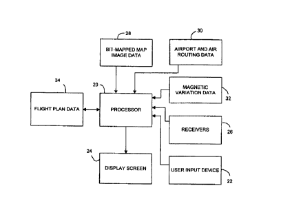
Figure 1 shows a diagram of a presently
preferred structure and arrangement for implementing a
system according to the present invention. A processor
20 is connected to a data storage device or various data
storage devices, so as to receive data therefrom. Data
stored for access by the processor 20 includes bit-
mapped map image data 28, and preferably includes
airport and air routing data 30 and magnetic variation
CA 02268065 1999-03-31
WO 98I15912 PCT/US97/19017
-6-
data 32. These and other types of data may be organized
in any desirable configuration for facilitating the
operation of a navigation system of the present
invention as described below. The data storage device
used to hold the bit-mapped map image data 28 is
presently preferred to be a CD-ROM. Read/write devices
may also be employed, however, and portions of the bit-
mapped map image data 28 are preferably temporarily
retained or cached in other data storage devices for
faster access as desired.
Processor 20 is also connected to a data storage
device so as to be able to store and retrieve data
therefrom. Such a data storage device is presently
preferred to be RAM or magnetic media or a combination
thereof, or other similar memory. Flight plan data 34
is stored in such a device. Data such as flight plan
data 34 is preferably preserved during loss of power.
This may be accomplished by battery backed RAM, routine
storage to a magnetic media, or other techniques as
desired.
The processor 20 is also connected to a display
screen 24 for displaying map images and information to a
user, and to at least one user input device 22 such as a
keyboard, keypad, touchscreen, mouse, or the like to
allow user input.
Processor 20 is also connected to receivers 26
for receiving information that varies with time and/or
with the location of the navigation system or the
location being viewed on the display of the navigation
system. Such data receivers may include a GPS receiver,
a port for receiving data from vehicle's sensors such as
from an airplane's own radar, a wireless data or voice
communication receiver or transceiver, and the like.
The receivers preferably include at least one receiver
for receiving weather data, particularly current weather
data such as National Weather Service data for the area
near the location of the navigation system, or,
optionally, near any other point selected for viewing,
CA 02268065 1999-03-31
WO 98I15912 PCT/LTS97/19017
and a GPS receiver for receiving global positioning
information.
The bit-mapped map image data 28 includes bit-
mapped map image data of at least one map system, and
preferably includes data of a plurality of map systems
' of mutually differing resolutions, such as map systems
data 42, 44, and 46 shown in Figure 2. The bit-mapped
map image data is produced for a given map system by
scanning the maps of the map system according to the
procedure outlined in U.S. Patent application serial No.
08/432,992 filed May 2, 1995 and incorporated herein by
reference. Briefly stated, the scanning and image
modification procedures disclosed in the above
application allow standardization of bit-mapped image
data for an entire map system, such that the processor
may use the data to display a bit-mapped map image
centered at any latitude and longitude input to the
processor, if within the map system, such that the map
image essentially fills the display screen and contains
20 no discontinuities except at the boundaries of the map
system, if any. The map systems included in the
presently preferred navigation system preferably include
such systems as NOAA's world aeronautical charts, NOAA's
sectional aeronautical charts, and the Defense Mapping
Agency's world maps and the like.
As shown in Figure 3) the airport and air
routing data 30 preferably includes airport location
data 48, airport runway data 52, airport services data
50, airport communications data 56, and various types of
overlay data 54. Overlay data 54 preferably includes
approach templates, instrument route charts, and other
useful information in graphical or other form.
In operation, the navigation system of Figure 1
is operable in two main modes, a GPS track mode and a
view maps mode as illustrated in Figure 4. In either
mode, the processor 20 uses the bit-mapped map image
data 28 to display a bit-mapped map image from a
selected map system, with the map image essentially
CA 02268065 1999-03-31
WO 98/15912 PCT/US97/19017
_g_
filling the display screen 24 and centered at a latitude
and longitude supplied to the processor. In the GPS
track mode, the latitude and longitude are supplied to
the processor by the GPS receiver 26, so that the
displayed map image is centered at the position of the
navigation system as sensed by the GPS receiver 26. In
the view maps mode, the latitude and longitude are
supplied to the processor 20 by the user directly
through the user input device 22 or from other data such
as the airport and air routing data, as selected by the
user through the user input device 22.
In either the GPS track mode or the view maps
mode, the processor updates the displayed image each
time it receives a new latitude and longitude. Thus if
the navigation system is moving, the latitude and
longitude sensed by the GPS receiver changes
periodically, and the map image is updated, giving the
appearance of a single continuously scrolling map image
moving across the surface of the display area of the
display screen.
The features displayed on the display screen in
either GPS track mode or view maps mode may be divided
into constant display features which are always shown on
the screen and selective display features which are
selectively shown on the screen in response to user
inputs through the user input device.
In either GPS track mode or view maps mode, the
preferred constant display features include the map
image with a pointer or icon showing the position of the
navigation system. The map image preferably is
displayed over essentially the entire surface of the
display area of the display screen, with the other
constant display features occupying the relatively small
remaining area. The icon is preferably an airplane, and
may if desired be made to point along the displayed map
image in the direction of the ground track as sensed by
the GPS receiver.
CA 02268065 1999-03-31
WO 98l15912 PCT/US97/19017
_g_
Other constant display features include menu
headings in a menu bar, a map type and scale or zoom
level window, a longitude and latitude window for
displaying the current longitude and latitude of the
pointer, a magnetic variation indicator to indicate when
magnetic variation compensation is in use, and a map
orientation indicator to indicate whether North-up or
South-up map image orientation is in use.
Selective display features which are displayed
selectively according to user inputs through the user
input device include a nearest airport window, a GPS
receiver status window) a navigation information window,
and a flight plan information window, and various types
of overlays. In the view maps mode, the selective
display features do not include the GPS receiver status
and the navigation information windows, as illustrated
in Figure 4.
The window-type selective display features (a11
those except the overlays feature) are preferably
displayed over a peripheral portion of the bit-mapped
map image. A currently preferred arrangement is shown
for example in Figure 11. Figure 11 represents the
display area of a display screen. The bit-mapped map
image occupies essentially all of the display area of
the display screen, but with the four window-type
selective display features overlaying the bit-mapped map
image at the right peripheral edge thereof. Each of the
selective display features is individually selectively
displayable. All may be displayed together as shown in
Figure 11, or any combination, or none, may be
displayed, as selected by user inputs through the user
input device.
When a route such as a flight plan is entered
into the navigation system and selected, the great
circle routes between waypoints along the route may be
displayed on the bit-mapped map images. When in GPS
tracking mode, the current position of the navigation
system is also shown, and the great circle route from
CA 02268065 1999-03-31
WO 98/15912 PCT/US97/19017
-10-
the current position to the next waypoint may also be
displayed. Such a display is shown schematically on the
bit-mapped map image area in Figure 11. A great circle
route is shown graphically by a line overlaid on the
display between waypoints 60 and 64. The actual
position of the navigation system is shown by pointer
62, and the great circle route from the actual position
to the next waypoint 64 is also shown by a line overlaid
on the display.
These preferred display arrangements provide
particular advantages in that the most basic and
important information is always displayed, but is
limited to a small, peripheral area of the display area,
allowing a relatively large viewing area for the map
image. Other important, but more detailed, information
is displayed in windows that are somewhat larger, but
still peripherally located, and which can be closed,
when desired. This provides ease of viewing and
comprehending the data presented on the viewing surface
of the display screen.
The overlays feature is not displayed in a
particular location on the display area of the display
screen. Instead, the overlays are displayed on map
image in such a manner that the overlaid features
correspond in size, position, and orientation to the
features of the.bit-mapped map image. Preferred charts
for use with the overlays feature include approach
templates for airports and instrument flight rules route
charts. Such charts may be formatted in the air routing
data as bit-mapped or vector graphics images, as
desired. A special feature that improves the
viewability of the overlaid information is that the bit-
mapped map image may be dimmed while the overlaid
information remains bright. Individual brightness
control may also be provided for each overlay, if
desired.
Also preferred for use with the overlays feature
is current weather information in the form of radar or
CA 02268065 1999-03-31
WO 98/15912 PCTlUS97/19017
-11-
satellite weather images, or current weather charts,
such as National Weather Service weather charts, or
other charts showing weather-related information such
as
frontal systems, storm systems, latest readings of wind
direction and speeds, temperature distributions,
barometric pressure distributions, and the like.
Information for producing and updating such
weather-related overlays is preferably received through
(a) data receivers) such as a port for receiving data
from a vehicle's sensors such as from an airplane's own
radar, a ground or satellite based wireless data and/or
voice communication receiver or transceiver or similar
link to the National Weather Service, the FAA, or
another weather data provider, and the like.
The use of bit-mapped map images for the maps
displayed in the navigation system of the present
invention, rather than raster graphics generated map
images, allows quick access to the various images and
low processing overhead to display and move the images.
This enables the present system to be implemented with
low cost processors, and to display moving map images
quickly and accurately, with real-time display of the
actual position of even a fast-moving vehicle such as
an
airplane. In orie presently preferred embodiment, the
present system is embodied in a laptop computer with a
CD-ROM drive for the first storage device and a hard
drive and RAM for the second storage device. A PCMIA-
socket GPS receiver is employed, and the entire unit is
then portable and, with batteries, cordless. The
keyboard and other input devices of the laptop serve as
the user input device. Processor power freed by the use
of bit-mapped images is used instead to perform various
other functions relating to the display of useful
information along with the map images.
The use of bit-mapped map images also allows the
inclusion of many more details than can practically be
included in a vector-mapped graphics data base. The
wealth of detail on the bit-mapped map images is
CA 02268065 1999-03-31
WO 98/15912 PCT/US97/19017
-12-
provided without large processing power cost. When
these images are combined with chart or other overlays,
pilots are provided with more information than with
other navigational systems.
Preferred command hierarchies for an embodiment
of a navigation system of the present invention are
shown in Figures 5-7. In Figure 5, preferred commands
under each of the main menu headings are shown.
Under Options, Exit exits the navigation system
(for use when running on a laptop or other general
purpose computer), Units allows a selection of the units
of measure used in the various displays. Magnetic
Variation toggles on and off the magnetic variation
compensation. Reset GPS resets the GPS receiver.
Switch Mode toggles between GPS tracking mode and view
maps mode.
Under Map, Change CD allows a CD containing bit-
mapped map image data and other data to be changed for
another. North/South Up toggles the orientation of the
map images displayed. Auto Orientation provides an
orientation with South-up if and only if the ground
track (the direction of travel relative to the ground)
is southward, otherwise a North-up orientation is
provided. Map 1, Map 2, and Map 3 change the map system
from which the currently displayed bit-mapped map image
is sourced to the map system selected. Overlays calls
the overlays commands shown in Figure 6.
As shown in Figure 6, Approach Plates, IFR
Routes may, or Weather Info may be selected. Other
useful types of information may also be included as
additional selections.
If Approach Plates is selected, the desired
approach plate is preferably selected by first selecting
an airport, then a runway at the selected airport. The
runway may be selected by number or other designation by
the Runway command, or by the types of navigation aid
available by the Nav. Aid Types command. The
appropriate approach plate is then overlaid on the
CA 02268065 1999-03-31
WO 98/15912 PCT/US97/19017
-13-
displayed bit-mapped map image with corresponding
features in proper alignment.
If Weather Info is selected, weather data for
the region shown in the displayed map image is overlaid
over the displayed map image. The weather data may be
in any of various forms, including local weather radar
images, national weather radar images, weather satellite
images, and current weather charts. If more than one of
these forms is implemented in a single navigation
system, the user may be permitted to select the desired
form. If the navigation system is to be used in a
vehicle, such as an aircraft, with radar capability, the
system may include a port for receiving weather-related
radar data from.the vehicle itself, for display overlaid
on the map image.
Returning to the command hierarchy of Figure 5,
the Zoom commands allow zooming within a given map
system. In and Out zoom one level in and out,
respectively. The Level choices zoom directly to the
indicated zoom level.
The Goto commands allow motion around the map
apart from GPS tracking and, when executed,
automatically causes a switch to view maps mode.
Latitude/Longitude allows entry of the latitude and
longitude of the position to which the pointer will
move. Airport allows selection of an airport by an
official identifier (preferably by ICAO identifier) then
moves the pointer to the selected airport. Nearest
airport moves the pointer to the nearest airport, while
the choices numbered 1-5 move the pointer to the
selected one of the five next nearest airports.
The Info command allows selection of an airport
as with the Goto commands, but the destination airport
(the destination of a currently selected flight plan) is
an additional choice. Choice of an airport under the
Info command results in display of the information
screen or information mode shown in Figure 9, and in
availability of~the further command hierarchy shown in
CA 02268065 1999-03-31
WO 98/15912 PCT/US97/19017
-14-
Figure 10. The.information screen shown in Figure 9
includes an airport information window containing
information about the selected airport, a runway
information window containing information about a
selected runway at the selected airport, and a
communications information/runway sketch window,
containing either information about a selected
communications channel of the selected airport, or a
sketch of the runways of the selected airport.
The airport information provided in the airport
information window is preferably thorough and detailed,
including such information as ownership status (civil,
military, civil/military, or private), name, City,
State, Country, reference longitude and latitude and
elevation, magnetic variation, longest runway length and
surface type, above ground height for the airport
traffic pattern, services and supplies available such as
oxygen types, fuel types, repair types, IFR capability,
etc., and the airport record date.
The runway information provided in the runway
information window is preferably similarly detailed,
including such things as the runway identifier, the
runway longitude and latitude, the length and width of
the runway, the true and magnetic bearings of the
runway, the surface type, the lighting type, and the
direction of turns for traffic flow. The runway sketch,
when shown, gives a representation of the runways with
true north up, the runway identifiers displayed near
each runway, and the selected runway highlighted.
The communications information, when shown,
provides details concerning the communications
frequencies of the selected airport, including the
number of channels, their call signs, types, and
frequencies, and any services provided by or on each
frequency.
The command hierarchy shown in Figure 10 is used
to control the display of the information screen. Exit
exits the information screen. airport allows a
CA 02268065 1999-03-31
WO 98/15912 PCT/US97/19017
-15-
different airport to be selected. The selections under
Communications allow the communications frequencies to
be displayed (Show) and allow toggling to the Next or to
the Previous frequency. The selections under Runway
allow the runway diagram to be displayed (Show) and
allow toggling to the Next or to the Previous runway.
Returning to the hierarchy shown in Figure 5,
the selections under Plan allow modifications t.o the
current flight plan. Add Waypoint allows a waypoint to
be added after the current point. Add Destination
allows a destination to be added at the end of the
current plan. Remove Waypoint removes the current
waypoint. Next Waypoint and Previous Waypoint toggle to
the next and previous waypoints respectively. Plan
Display toggles open and closed the flight plan
information window shown in Figure 11. Virtual Flight
causes the bit-mapped map image display to track through
the current flight plan, employing and displaying the
great circle route between waypoints. Flight Plan
brings up a command list like that of Figure 7 and a
display as shown in Figure 8.
The preferred flight plan display represented in
Figure 8 is a window having column headings across the
top of "leg," "from," "to," "distance," and "heading."
Multiple (preferably at least three) legs of the flight
plan are preferably displayed under these headings. The
layout of information on the middle leg is shown, with
the top and bottom legs omitted for clarity. The leg
information includes the ICAO identifiers of the
waypoints, and the distance and heading from the "from"
way point to the "to" waypoint. Under the ICAO
identifiers is displayed the name of the "to" waypoint.
Below the plan leg information is a display of
the startpoint of the plan, the destination of the plan,
and the total distance of the plan. Below that is a
display of the plan number and name, and the total
number of waypoints in the plan.
CA 02268065 1999-03-31
WO 98/15912 PCT/LJS97/19017
-16-
The commands in the list in Figure 7 allow
manipulation of the data stored as flight plans and
displayed as shown in Figure 8. Plan Toggle toggles up
or down to other plans. Waypoint Toggle toggles up or
down to other legs within a plan, with the selected leg
highlighted. Cancel Changes allows canceling all of
current editing performed on a flight plan. Enter
causes the changes in the currently edited flight plan
to be stored, replacing the previous version.
Destination adds a destination to the end of the
currently displayed flight plan. Delete deletes a
currently highlighted leg of a flight plan. Insert
inserts a new leg after the currently highlighted leg of
the flight plan. Reverse reverses the current flight
plan. Clear clears the current flight plan from the
second memory device. Edit allows editing of the
highlighted leg of the flight plan. Name allows giving
of or editing of a name for the current flight plan.
View forces the map image display into view maps mode
and places the pointer at the location of the
highlighted waypoint or destination.
In view of the many possible embodiments in
which the present invention may be implemented, it
should be recognized that the illustrated embodiment
above is only a preferred example of the invention and
should not be taken as a limitation on the scope of the
invention. Rather, the invention is defined by the
following claims. We therefore claim as our invention
a11 such embodiments as come within the scope and spirit
of these claims.