Note: Descriptions are shown in the official language in which they were submitted.
CA 02268104 1999-04-08
WO 98!15850 PCT/US97/18511
TITLE: METHOD OF OBTAINING IMPROVED GEOPHYSICAL
INFORMATION ABOUT EAIItTH FORMATIONS
Field of the Invention
s This invention relates generally to the placement of wellbores and
management of
the corresponding reservoirs and more particularly to selectively drilling one
or more
wellbores for conducting seismic surveys therefrom to improve the seismographs
and
utilizing the improved seismographs to determine the type and course of
wellbores for
developing a field. The method of the present irwention further relates to
obtaining
l o seismic information during drilling of the wellbo:res and during
production of hydrocarbons
for improving hydrocarbon production from the reservoirs. The method of the
present
invention further relates to using the derived seismic information for
automatically
controlling petroleum production wells using downhole computerized control
systems.
is Background of the Invention
Seismic surveys are performed from surface locations to obtain maps of the
structure of subsurface formations. These surveys are in the form of maps
(referred herein
as seismographs") depicting cross-section of the earth below the surveyed
region or area.
Three dimensional ("3D") surveys have become common over the last decade and
provide
2 o significantly better information of the subsurface formations compared to
the previously
available two-dimension ("2D") surveys. The 31~ surveys have significantly
reduced the
number of dry wellbores. Still, since such seisln;ic surveys are performed
from the surface,
they lose resolution due to the distance between the surface and the desired
hydrocarbon-
bearing formations, dips in and around the subsurface formations, bed boundary
2 s delineations, which is typically several thousand feet.
CA 02268104 1999-04-08
WO 98/15850 PCT/US97/18511
Surface seismic surveys utilize relatively low frequency acoustic signals to
perform
such surveys because such signals penetrate to greater depths. However, low
frequency
signals provide lower resolution, which provides iow resolution seismographs.
High
frequency signals provide relatively high resolution boundary delineations,
but attenuate
relatively quickly and are, thus, not used for performing seismic surveys from
the surface.
Only rarely would an oil company drill a wellbore without first studying the
seismographs for the area. The number of wellbores and the path of each
wellbore is
1 o typically planned based on the seismographs of the area. Due to the
relatively low
resolution of such seismographs, wellbores are frequently not drilled along
the most
effective wellpaths. It is therefore desirable to obtain improved seismographs
prior to
drilling production wellbores. Additionally, more and more complex wellbores
are now
being drilled, the placement of which can be improved with high definition
seismographs.
Furthermore, relatively recently, it has been proposed to drill wellbores
along contoured
paths through and/or around subsurface formations to increase potential
recovery or to
improve production rates of hydrocarbons. In such cases, it is even more
critical to have
seismographs that relatively accurately depict the delineation of subsurface
formations.
2 o Conventionally, seismographs have been updated by (a) performing borehole
imaging, which is typically conducted while drilling a wellbore and (b) by
cross-well
tomography, which is conducted while between a number of producing wells in a
region.
In the case of borehole imaging, a seismic source seismic source generates
acoustic signals
during drilling of the wellbore. A number of receivers placed on the surface
receive
2
CA 02268104 1999-04-08
WO 98115850 PCTIUS97118511
acoustic reflections from subsurface formation boundaries, which signals are
processed to
obtain more accurate bed boundary information about the borehole. This
technique helps
improve the surface seismographs in piecemeal basis. Data from each such well
being
drilled is utilized to continually update the seismographs. However, such
wellbores are
s neither planned nor optimally placed for the purpose of conducting
subsurface seismic
surveys. Their wellpaths and sizes are determined based upon potential
recovery of
hydrocarbons. In the case of cross-well tomography, acoustic signals are
transmitted
between various transmitters and receivers placed in producing wellbores. The
effectiveness of such techniques are reduced if the wellbores are not
optimally placed in
i o the field. Such techniques would benefit from wellbores which are planned
based on
improved seismographs.
In the control of producing reservoirs, it: would be useful to have
information about
the condition of the reservoir away from the borehole. Crosswell techniques
are available
i5 to give this kind of information. In seismic tomography, a series of 3-D
images of the
reservoir is developed to give a 4-D model or the reservoir. Such data has
usually been
obtained using wireline methods in which seismic sensors are lowered into a
borehole
devoted solely for monitoring purposes. To use such data on a large scale
would require a
large number of wells devoted solely to monitoring purposes. Furthermore,
seismic data
2 o acquired in different wireline runs commonly suffers from a data mismatch
problem where,
due to differences in the coupling of the sensor;. to the formation, data do
not match.
The present invention addresses the above-noted problems and provides a method
of conducting subsurface seismic surveys from bane or more wellbores. These
wellbores
CA 02268104 1999-04-08
WO 98115850 PC'T/US97118511
may be drilled for the purpose of conducting such surveys. Alternatively,
permanently
implanted sensors in a borehole that could even be a production well could be
used to
gather such data. The data from such subsurface surveys is utilized to improve
the
previously available seismographs. The improved seismographs are then utilized
to plan
the production wellbores. Borehole seismic imaging and cross-well tomography
can be
utilized to further improve the seismographs for reservoir management and
control.
SUMMARY OF THE INVENTION
i o The present invention provides a method for forming wellbores. In one
method,
one or more wellbores are drilled along preplanned paths based in part upon
seismic
surveys performed from the surface. An acoustic transmitter transmits acoustic
signals at
one or more frequencies within a range of frequencies at a plurality of spaced
locations. A
plurality of substantially serially-spaced receivers in the wellbores and/or
at surface receive
is signals reflected by the subsurface formations. While the acoustic
receivers are
permanently deployed downhole, the acoustic transmitter may optionally be
positioned
permanently or temporarily
downhole; or may be positioned permanently or temporarily at the surface of
the well The
receiver signals are processed by conventional geophysical processing methods
to obtain
2 o information about the subsurface formations. This information is utilized
to update any
prior seismographs to obtain higher resolution seismographs. The improved
seismographs
are then used to determine the profiles of the production wellbores to be
drilled. Borehole
seismic imaging may then be used to further improve the seismographs and to
plan future
wellbores. Information gathered from tomographic surveys carried out over a
period of
4
CA 02268104 1999-04-08
WO 98/15850 PCTIUS97118511
time can be used to map changes in the reservoir conditions away from the
boreholes and
appropriate control measures may be taken. Fiber optic sensors, along with a
light source,
can also be used to detect the acoustic and seisnuc signals.
s Another embodiment of the present invention includes permanent downhole
formation
evaluation sensors which remain downhole throughout production operations.
These
formation evaluation sensors for formation measurements may include, for
example,
gamma ray detection liar formation evaluation, neutron porosity, resistivity,
acoustic
i o sensors and pulse neutron which can, in real time, sense and evaluate
formation parameters
including important information regarding water migrating from different
zones.
Permanently installed fiber optic sensors can also be used to measure acoustic
signals,
pressure, temperature and fluid flow. These are utilized to in the seismic
mapping as well
as in obtaining and upodating reservoir models and in managing the production
of
i s hydrocarbons.
On particularly advantageous permanent downhole sensor installation involves
the
permanent placement of acoustic transmitters arid receivers downhole in oil,
gas or
injection wells for collecting real time seismic data. This seismic data is
used for, among
20 other purposes, (a) defining the reservoir; (b) defining distribution of
oil, water and gas in
a reservoir with respect to time; (c) monitoring the saturation, depletion and
movement of
oil, water and gas; and (d) monitoring the progress of a fracturing operation.
In contrast to
prior art seismic monitoring, the data obtained by the present invention is
real time.
CA 02268104 1999-04-08
WO 98115850 PCTIUS97/18511
BRIEF DESCRIPTION OF THE DRAWINGS
For detailed understanding of the present invention, references should be made
to
the following detailed description of the preferred embodiment, taken in
conjunction with
the accompanying drawings, in which like elements have been given like
numerals,
wherein:
FIG. 1 shows a schematic illustration of the placement of a wellbore and
1 o corresponding transmitters and receivers for conducting subsurface seismic
surveys
according to an embodiment of the present invention.
FIG. la shows a receiver grid for use at the surface according to an
embodiment
of the present invention.
FIG. 2 shows a schematic illustration of the placement of a plurality of
wellbores
and corresponding transmitter and receivers for conducting subsurface seismic
survey
according to an embodiment of the present invention.
2 o FIG. 3 shows a schematic illustration of multiple production wellbores
formed for
producing hydrocarbons utilizing the information obtained from surveys
performed
according to the present invention.
FIG. 4 shows a schematic illustration of multiple production wellbores formed
for
6
CA 02268104 1999-04-08
WO 98115850 PCTIUS97118511
producing hydrocarbons utilizing the information obtained from surveys
performed
according to the present invention, wherein at least one of the production
wellbores is
formed from the wellbore formed for performing subsurface seismic survey.
FIG. 5 is a diagrammatic view of an acoustic seismic monitoring system in
accordance with the present invention.
DETAILED DESCRIPTION OF THE PREFERRED EMBODIMENTS
l o In general, the present invention provide; methods for obtaining improved
seismic
models prior to drilling production wellbores, drilling wellbores based at
least partially on
the improved seismic models and method for improving reservoir modeling by
continued
seismic survey during the life of the production wellbores.
l s FIG. 1 shows a schematic illustration of an example of the placement of a
survey
wellbore and receivers and the source points for conducting subsurface seismic
surveys
according to the present invention. For the purposes of illustration and ease
of
understanding, the methods of the present invention are described by way of
examples and,
thus, such examples shall not be construed as linutations. Further, the
methods are
2 o described in reference to drilling wellbores offshore but are equally
applicable to drilling of
wellbores from onshore locations. In this configuration, a survey wellbore 10
is planned
based on any preexisting information about the "ubsurface formation structure.
Such
information typically includes seismic surveys performed at the surface and
may include
information from wellbores previously formed in the same or nearby fields. As
an
7
CA 02268104 1999-04-08
WO 98115850 PGTlUS97118511
example, FIG. 1 shows non-hydrocarbon bearing formations Ia and Ib separated
by
hydrocarbon bearing formations IIa and IIb (also referred to herein as the
"production
zones" or "reservoirs"). After the wellpath for the survey wellbore 10 has
been
determined, it is drilled by any conventional manner. Typically, reservoirs
are found
s several thousand feet deep from the earth's surface and in many instances
oil and gas is
trapped in multiple zones separated by non-hydrocarbon bearing zones. It is
preferred that
the hydrocarbon bearing formations be not invaded by drilling fluids and other
drilling
activity except as may be necessary to drill wellbores for recovering
hydrocarbons from
such formations. Therefore, it is generally preferred that the survey wellbore
10 be placed
1 o in a non-hydrocarbon bearing formation, such as formation Ia.
Additionally, it is preferred
that the survey wellbore be placed relatively close to and along the
reservoirs.
Typically, production wellbores are relatively large in diameter, generally
greater
than seven inches (7") in diameter. Such large diameter wellbores are
expensive to drill.
15 Survey wellbores, such as exemplary wellbore 10, however, need only be
large enough to
accommodate acoustic receivers, such as hydrophones, fiber optic sensors, and
an acoustic
source moved within the wellbore as more fully explained later. Such small
diameter
wellbores can be drilled relatively inexpensively in non-producing zones
without
concerning invading formations near the borehole. Additionally, relatively
inexpensive
2 o fluids may be utilized to drill such wellbores. As noted earlier,
reservoirs typically lie
several thousand feet below the earth's surface and thus the survey wellbore,
such as
wellbore 10, may be placed several thousand feet below the earth's surface.
Additionally, if
the survey wellbore is not eventually going to be utilized for purposes that
would require
casing or otherwise completing the wellbore, such wellbore may be filled with
a heavy
8
CA 02268104 1999-04-08
WO 98115850 PCT/L1S97118511
fluid (called the "kill-weight" fluid) to prevent collapse of the wellbore.
Once the survey wellbore 10 has been drilled, a receiver string or line 12
with a
plurality of serially spaced receivers 12a is placed along the wellbore. The
receiver
s locations 12a are preferably equi-spaced and each receiver location 12a may
include one
or more receivers, such as hydrophones, seismometers or accelerometers. The
receivers
could also be single or a plurality of fiber optic strings or segment, each
such segment
containing a plurality of spaced apart fiber optic sensors: in such a case, a
light source and
detector (not shown) are disposed used in the wellbore to transmit light
energy to the
l o sensors and receiver the reflected light energy fi~om the sensors and a
suitably placed data
acquisition and processing unit is used for processing the light signals. The
use of such
receiver lines is known in the art and is not described in detail herein.
Alternatively or in
addition to the receiver string 12, one or more receiver lines, such as lines
14, each having
a plurality of serially spaced acoustic sensors 14~a may be placed on the
ocean bottom 16
is for relatively shallow water applications. For relatively deep water
applications, one or
more receiver lines may be placed a relatively short distance below the water
surface 22.
Receiver lines 22 are made buoyant so that they remain at a desired distance
below the
water surface. FIG. 1a shows a plan view of an exemplary configuration of a
plurality of
receiver lines Rl-Rn that may be placed on the earth's surface. The receivers
in each line
2 o designated by r;;, where l represents the line and j represents the
sequential position in the
line l. The receivers in adjacent lines are showm staggered one half the
distance between
adjacent receivers.
ca
CA 02268104 2001-09-24
wo mssso Pcrrt~s9masm
The same fiber-optic sensor could be used as an acoustic sensor and to
determine
other downhole conditions, such as the temperature, pressure and fluid flow.
The use of
f ber optic sensors in downhole tools is known.
Referring back to FIG.1, to perform a seismic survey from the survey wellbore
10, a seismic source (acoustic transmitter) is energized at a first location,
such as location
I2s, . The acoustic signals travel around the survey wellbore 10 and are
reflected and
refracted by the bed boundaries between the various formations. The reflected
waves,
i o such as waves 30 are detected by the receivers I2s in the survey wellbore
12. The
detected signals are transmitted to a surface control unit 70, which processes
the detected
signals according to known seismic processing methods. Desired information
relating to
the survey activity is displayed on the display and any desired information is
recorded by
the recorder. The control unit preferably includes a computer with a seismic
data
i s processing programs for performing processing receiver data and for
controlling the
operation of the source 15.
The source 15 is then moved to the next location in the wellbore 10 and the
above
process is repeated. When receiver Iines, such as lines 14 are deployed on the
sea bottom
20 16, then the signals 32 reflected from the subsurface formations are
detected by the
receivers 14a. The signals detected by the sensors 14a are then collected and
processed by
the control unit 70 in the manner described earlier. When receiver lines 18
are suspended
in the ocean water 20 then reflected signals as shown by lines 34 are detected
by the
receivers 18a in lines 18. The signals received by the Iines 18 are then
processed by the
CA 02268104 1999-04-08
WO 98115850 PCT/I1S97118511
control unit 70 in the manner described earlier. It should be noted that for
the purpose of
this embodiment of the invention any combination of the receiver lines may be
utilized.
Additionally, the source may be activated at suriPace locations.
s In the first embodiment of the invention, the source 15 is preferably
conveyed into
the survey wellbores 10 and moved to each of the source points 15s; . This
allows utilizing
only one source for performing the survey. The source 15 preferably is adapted
to
transmit acoustic signals at any frequency within a range of frequencies. The
control unit
70 is used to alter the amplitude and frequency of the acoustic signals
transmitted by the
io source 15. Since the survey wellbore is strategically placed from
relatively short distance
from some or all of the producing formations, a relatively high frequency
signals may be
utilized to obtain high resolution seismic maps fir short distances, which is
nor feasible
from any seismic surveys performed from the surface. Additionally, the source
15 may be
oriented in any direction to transmit acoustic signals in a particular
direction (herein
1 s referred to as the focused signals). This can allow obtaining true three
dimensional bed
boundary information respecting formations surrounding the survey wellbore I0.
During
drilling of the wellbore, core cuttings from knovvn depths provide information
about the
rock structure, which in turn can be used to determine relatively accurately
the acoustic
velocities of some of the formations surrounding; the survey wellbore I0.
These velocities
2 o are utilized in processing the signals detected by the receiver lines,
such as lines, such as
line 12, 14 and 18. This provides more accuratE; delineation of bed boundaries
compared
to surface seismic surveys which typically use e;;timated values of acoustic
velocities for
subsurface formations.
l :l
CA 02268104 1999-04-08
WO 98115850 PCTNS97/18511
The information obtained from the survey as described above is used to update
preexisting seismic models. This may be done by combining the data obtained
from the
survey performed from the survey wellbore 10 or by any other known method.
Additionally actual acoustic velocities of the subsurface formations obtained
herein can be
utilized to update the seismic models of the area.
Now referring to FIG 1a, the source line defined by s1 -sP is shown to be
symmetrically placed in relation to the surface seismic lines Rl -R" . It is
preferred to
1 o utilize symmetrical receiver and transmitter configurations because it
simplifies processing
of data.
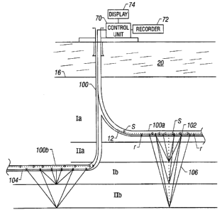
FIG. 2 shows a schematic illustration of the placement of a plurality of
wellbores
and corresponding transmitter and receiver lines for conducting subsurface
seismic survey
~ 5 according to one method of one embodiment of the invention. In this
configuration, a
survey wellbore 100 is formed along a wellpath based on the prior seismic and
other
subsurface formation information available. The wellbore 100 has a first
branch wellbore
100a placed above the first reservoir lIa and a second branch wellbore IOOb
placed above
and along a second reservoir IIb. Other configurations for multiple survey
wellbores may
2o be adopted based upon the location of reservoirs to be developed. For
example, separate
wellbores may be drilled from different surface locations. A survey wellbore
may be
drilled along a dip to more precisely map the dipping formation utilizing
relatively high
frequency acoustic signals.
12
CA 02268104 1999-04-08
WO 98J15850 PCT/US97/18511
Each of the survey wellbores, such as wellbores 100a and 100b are lined with a
receiver line 102 and 104 respectively. To conduct seismic survey from
wellbore 100a, a
transmitter is activated from each of the source points s. The reflected
signals 106 are
s detected by the receivers r in the line 102, receivers in any other survey
wellbore and by
any other receivers placed on the surface. The data from the receivers is then
processed by
the control unit in the manner described earlier ,with respect to FIG. 1 to
obtain
information about the subsurface formations. Seismic data may be obtained at
different
frequencies and by utilizing focused signals in the manner described earlier
with respect to
1 o FIG. 1.
FIG. 3 shows a schematic illustration of multiple production wellbores formed
for
producing hydrocarbons utilizing the information obtained from surveys
performed
according to one embodiment of the invention. Once the subsurface geological
15 information has been updated, the size and the placement of production
wellbores, such as
wellbores 100, 100a and 100b for developing a region are determined based upon
the
updated seismographs or subsurface models. The desired production wellbores
are drilled
and completed to produce hydrocarbons. It is desirable to place a plurality of
receivers,
such as receivers 202 in wellbore 200a and receivers 206 in wellbore 200b. In
some cases
2 o it may be desirable to leave the receiver line 12 in the survey wellbore
10. During the life
of the wellbores 200a and 200b, acoustic sources may be activated at selective
locations in
any of the production wellbores and in the survey wellbore 10. The receivers
in the
various wellbores detect signals corresponding to the transmitted signals. The
detected
signals are then processed to determine the condition of the various
reservoirs over time.
13
CA 02268104 1999-04-08
WO 98/15850 PCTlUS97/18511
This information is then used to update reservoir models. The updated
reservoir models
are subsequently utilized to manage production from the various wellbores in
the field.
The updated models may be used to selectively alter production rates from any
of the
production wellbores in the field, to shut in a particular well, to workover a
particular
production wellbore, etc. The permanent availability of receiver lines in the
survey
wellbore I0, relatively close to the production wellbores 200a and 200b,
provides more
accurate information about the subsurface formations than surveys conducted
from the
surface. However, surface seismic surveys, if performed after the wellbores
have been
producing, may still be updated with information obtained from surveys
performed using
1 o survey wellbore 10.
FIG. 4 shows a schematic illustration of multiple production wellbores formed
for
producing hydrocarbons utilizing the information obtained from surveys
performed
according to one embodiment of the invention, wherein at least one of the
production
wellbores is formed from the wellbore formed for performing subsurface seismic
survey.
In some cases it may be desirable to drill a survey wellbore which can later
be utilized to
form production branch wellbores therefrom. FIG. 4 shows the formation of a
survey
wellbore 300a from a common vertical well section 300. The wellbore 300 is
first used to
perform seismic surveys in the manner described herein and then one or more
production
2o wellbores, such as wellbores 300b and 300c, are formed from the survey
wellbore 300a.
Additional production wellbores, such as wellbore 310 may be formed from the
common
wellbore section 300 or from other surface locations (not shown) as desired.
Receivers
302a and 312a respectively shown in the wellbores 300a and 310 perform the
same
functions as explained earlier with respect to FIGS.1-3.
14
CA 02268104 1999-04-08
WO 98115850 PCT/US97118511
Another aspect of the invention is the use of permanently installed downhole
acoustic sensors. FIG. 5 depicts a schematic representation of the acoustic
seismic
monitoring system as described immediately above. FIG. 5 more particularly
depicts a
production well 410 for producing oil, gas or the like. Well 410 is defined by
well casing
412 which is cemented or otherwise permanently positioned in earth 414 using
an
appropriate cement 416. Well 410 has been completed in a known manner using
production tubing with an upper section of production tubing being shown at
416A and a
lower section of production tubing being shown at 416B. Attached between
production
l o tubing 416A and 416B, at an appropriate location, is the permanent
acoustic seismic
sensor in accordance with the present invention which is shown generally at
418. Acoustic
seismic sensor 418 comprises a housing 420 having a primary flow passageway
422 which
communicates with and is generally in alignment with production tubing 416A
and 416B.
Housing 420 also includes a side passageway 424 which is laterally displaced
from primary
is flow passageway 422. Side passageway 424 is defined
by a laterally extending section 426 of housing 420 and an interior dividing
wall 428.
Positioned within side passageway 424 is a downhole electronics and control
module 430
which is connected in series to a plurality of permanent acoustic receivers
432 (e.g.,
hydrophones, seismometers and accelerometers). The acoustic receivers 432 are
placed
20 longitudinally along production tubing 416 (and therefore longitudinally
along the wall of
the borehole) in a region of the geological forniation which is of interest in
terms of
sensing and recording seismic changes with respect to time. At the surface 434
is a surface
control system 436 which controls an acoustic transmitter 438. As discussed,
transmitter
438 may also be located beneath the surface 4?~4. Transmitter 438 will
periodically
:l5
CA 02268104 2001-09-24
wo 9anssso Pcrrus9~nssm
transmit acoustic signals into the geological formation which are then sensed
by the array
of acoustic receivers 432 with the resultant sensed data being processed using
known
analysis techniques.
A more complete description of wellbores containing permanent downhole
formation evaluation sensors can be found in U.S. Pat. No . 5,662,165
1 o As discussed in trade journals such as in the articles entitled "4D
Seismic Helps
Track Drainage, Pressure Compartmentalization," Oil and Gas Journal, Mar. 27,
1995, pp
55-58, and "Method Described for Using 4D Seismic to Track Reservoir Fluid
Movement," Oil and Gas Journal, Apr. 3, 1995, pp. 70-74
15 seismic monitoring of wells over time is becoming an important tool in
analyzing and predicting well production and performance. Prior to the present
invention,
such seismic monitoring could only be done in near real time using known wire-
line
techniques; or on sensors mounted on the outside of tubing of various sorts
for shallow
applications (never in producing wells). Examples of such seismic monitoring
are
2o described in U.S. Pat. No. 5,194,590; the article "Time-Lapse crosswell
seismic tomogram
Interpretation: Implications for heavy oil reservoir characterization, thermal
recovery
process monitoring and tomographic imaging technology" Geophysics v. 60, No.
3,
(May-June), p 631-650; and the article "Crosswell seismic radial survey
tomograms and
the 3-D interpretation of a heavy oil steamflood." Geophysics v. 60, no. 3,
(May-June) p
16
CA 02268104 2001-09-24
WO 98115850 PCTIUS9~n stc> >
651-659. However, in
accordance with the present invention, a significant advance in seismic
monitoring is
accomplished by installing the seismic (e.g., acoustic) sensors as a permanent
downhole
installation in a well. A plurality of seismic transmitters, as described in
U. S. Patent
5,662,165 are used as sources of seismic energy at boreholes at known
locations. The
seismic waves detected at receivers in other boreholes, upon proper analysis,
provide a
detailed three dimensional picture of a formation and fluids in the formation
with respect
to time. Thus, in accordance with this invention, a well operator has a
continuous real time
three dimensional image of the borehole and surrounding formation and is able
to compare
1 o that real time image with prior images to ascertain changes in the
formation; and as
discussed in detail above, this constant monitoring can be done from a remote
location.
Such an imaging of fluid conditions is used to control production operations
in the
reservoir. For example, an image of the gas-water contact in a producing gas
reservoir
i5 makes it possible to take remedial action before water is produced in a
well by selectively
closing sleeves, packers, safety valves, plugs and any other fluid control
device downhole
where it is feared that water nught be produced without remedial action. In a
steam-flood
or C02 flood operation for secondary recovery of hydrocarbons, steam or COz
are injected
into the reservoir at selected injection wells. The steam or C02 drive the oil
in the pore
2 o spaces of the reservoir towards the producing wells. In secondary recovery
operations, it
is critical that the steam or C02 not enter the producing wells: if a direct
flow path for
steam or CO~ is established between the injection well and the recovery well
(called a
breakthrough), fiirther "flushing" operations to recover oil are ineffective.
Monitoring of
the position of the steam/oil or C02/oi1 interface is therefore important and
by closing
17
CA 02268104 1999-04-08
WO 98/15850 PCTlUS97/18511
sleeves, packers, safety valves, plugs and any other fluid control device in a
producing well
where breakthrough is imminent, the flow patterns can be altered sufficiently
to avoid a
breakthrough. In addition, sleeves and fluid pressure control devices can be
operated in
the injection wells to affect the overall flow of fluids in the reservoir. The
downhole
s seismic data for performing the tomographic analysis is transmitted uphole
using methods
described in U.S. Patent 5,662,165, gathered by the control center and
transmitted to a
remote site where a powerful digital computer is used to perform the
tomographic analysis
in accordance with methods described in the patent and references above.
l o Another aspect of the invention is the ability to control a fracturing
operation. In a
"frac job", fluid at a high pressure is injected into a geologic formation
that lacks adequate
permeability for the flow of hydrocarbons. The injection of high pressure
fluid into a
formation at a well has the effect of fracturing the formation. These
fractures generally
propagate away from the well in directions determined by the properties of the
rock and
is the underground stress conditions. As discussed by P.B. Wills et al in an
article entitled
"Active and Passive imaging of Hydraulic fractures" Geophysics, the Leading
Edge of
Exploration, July, p 15-22, (incorporated herein by reference), the use of
downhole
geophones in one well (a monitor well) makes it possible to monitor the
propagation of
fractures from another well in which fracturing is being induced. The
propagating fracture
2 o in the formation acts as a series of small seismic sources that emit
seismic waves. These
waves can be recorded in the sensors in the monitor well and based upon the
recorded
signals in a number of monitor wells, the active edge of the fracture can be
mapped.
Having such real-time observations makes it possible to control the fracturing
operation
itself using the methods of this invention..
18
r
CA 02268104 1999-04-08
WO 98115850 PCT/US97/18511
While the foregoing disclosure is directed to the preferred embodiments of the
invention various modifications will be apparent to those skilled in the art.
It is intended
that all variations within the scope and spirit of the appended claims be
embraced by the
foregoing disclosure. Examples of the more important features of the invention
have been
summarized rather broadly in order that the detailed description thereof that
follows may
be better understood, and in order that the contributions to the art may be
appreciated.
There are, of course, additional features of the invention that will be
described hereinafter
and which will form the subject of the claims appended hereto.
1 ~~