Note: Descriptions are shown in the official language in which they were submitted.
' CA 02269957 1999-04-22
i.
~1~ PC-4151/
AUTOMATED GUIDED APPARATUS SUITABLE FOR TOPING
APPLICATIONS
TECHNICAL FIELD
The instant invention relates to surveying techniques in general and, more
particularly, to an automated positioning apparatus especially suited for
generating mine
tunnel outline plan views.
BACKGROUND ART
Mine tunnel plan views ("TOPES' are required for underground mine planning.
Present techniques require teams of skilled surveyors using conventional
surveying
techniques and equipment to physically traverse the slopes and drifts to
obtain the raw data
for the topes. The raw data consists of point to point measurements. The data
collected by
the surveyors is imported into a CAD package to produce mine tunnel plan
views.
Sending surveying crews into underground excavations can be dangerous and
tedious work. Moreover, the assembling and utilization of highly skilled
personnel
contributes to the cost of underground mining.
CA 02269957 1999-04-22
-2- PC-4151/
Due to the ceaseless press of cost reduction and heightened safety concerns,
there
is a continuing desire on the part of hard rock miners to automate mining
systems. By
automating as many and minimizing cycles as possible, the dangers and expenses
caused
by the presence of personnel at the actual working zones of the mine may be
reduced. By
placing the miner or other mine professional in a safe and secure re~n~te
location,
preferably at the surface, increased safety, cost efficiency and production
are encouraged .
In particular, robotic mining techniques require dependable navigation and
positioning systems. For surface mining (as well as other activities),
increasing success
has been found with the use of global positioning systems utilizing earth
satellite
navigation.
In underground mines and in certain surface structures, the signals from the
orbiting satellites cannot reach the targeted equipment. Accordingly,
sophisticated dead
reckoning systems have been developed. Typical techniques utilize sound,
electromagnetic
means (lasers, visible light, radar) or gyroscopes or combinations thereof to
remotely guide
and operate mobile underground equipment.
In particular, the coal mining industry has demonstrated encouraging results
in
employing automated mining equipment.
U.S. patent 4,023,861 discloses a tunneling machine having a gyroscope
detector
and a laser beam detector. The measured data maintains the heading of the
machine as it
cuts into the heading face.
U.S. patent 4,884,847 discloses, in a very broad fashion, a method for
operating a
robotic miner conveyor by, in part, comparing current and previously stored
mine
parameters. The patent also states that the invention, without providing too
many details,
can be used to map mines.
A difficulty with remotely operated equipment is securing an initial reference
- -
datum point in X-Y-Z space. Due to the relative complex location algorithms
used in
navigation systems, the jumping off point must be measured with great accuracy
otherwise
even small errors will quickly become magnified thereby throwing offthe
reconnoitering
ability of the apparatus. This problem is especially onerous if a toping
system is involved.
Any deviation may render the resulting map worthless when critical parameters
are at
stake.
Accordingly, there is a need to produce less labor intensive accurate topes of
underground excavations and enclosed structures.
CA 02269957 2001-06-O1
X1790-1815
3
SUN~1ARY OF THE INVENTION
There is provided a mobile automated positioning
apparatus that is capable of accurately traversing and
measuring an underground excavation or structure for topes and
other applications.
The apparatus includes an inertial measurement unit,
central processing unit, laser range finder, laser scanner,
laser pointer, gray scale vision system and a mobile platform.
The apparatus is capable of accurately initializing
its position and confidently traversing the location. As the
apparatus trundles about, it collects data for accurate topes.
The invention is especially useful for underground
tunnel surveying and building surveys. It may also be used for
guiding other underground and surface vehicles.
In summary the invention provides an automated
guidance and measuring apparatus, the apparatus comprising a
support disposed in an environment, an inertial measurement
unit affixed to the support, at least one distance measuring
unit capable of determining the distance between a site on the
support and a spaced structural member of the environment, a
vision system processor for locating a predetermined object in
proximity of the apparatus within an acceptable margin of
inexactitude and for initially determining the location of the
apparatus in the environment, a central processing unit
intelligence coordinator communicating with the inertial
measurement unit and the distance measuring unit and the vision
system processor, means for continuously updating and
determining the location of the apparatus in response to the
inertial measurement unit, and an image receiver connected to
the vision system processor.
CA 02269957 2001-06-O1
61790-1815
3a
According to another aspect the invention provides a
method for measuring and navigating a mobile platform through a
predetermined area having at least one surface, the method
comprising: a) providing the mobile platform with an inertial
measurement unit; b) causing the inertial measurement unit to
communicate with a central processing unit, the central
processing unit capable of storing and updating location
parameters of the predetermined area; c) determining a distance
between the mobile platform and a surface of the predetermined
area and introducing the distance to the central processing
unit; d) utilizing a gray scale field of view edge coordinate
finder to detect a known marker in the predetermined area to
determine an initial location of the mobile platform; e)
causing the mobile platform to move through the area at a rate
to enable the inertial measurement unit to determine the
current location of the mobile platform in the area; f) storing
and updating the location parameters of the predetermined area
to the central processing unit; and g) determining, measuring
and recording selected dimensional characteristics of the
predetermined area.
BRIEF DESCRIPTION OF THE DRAWINGS
Figure 1 is a schematic representation of an
embodiment of the invention;
Figure 2 is a plan view of an embodiment of the
invention;
Figure 3 is a plan view of an alternative embodiment
of the invention;
Figure 4 is a representative of an optical feature of
an embodiment of the invention;
CA 02269957 2001-06-O1
61790-1815
3b
Figure 5 is an example of a partial tope.
PREFERRED EMBODIMENT OF THE INVENTION
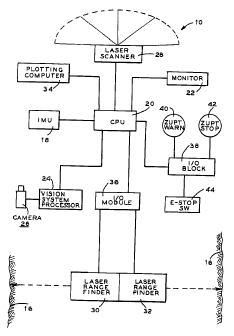
Referring to Figure l, there is shown a schematic
diagram of a toping apparatus 10. The apparatus 10 is mounted
on a self-propelled mobile platform 12. (See Figure 2).
The platform 12 may include an internal combustion
motor or an electric motor (not shown). Any form of
translation means (14), wheels or tracks, may be employed as
long as the apparatus 10 may be steered as it travels through a
mine heading 16.
The instant apparatus 10 is designed to delineate
mine walls quickly and accurately. In optical surveying, the
odolites measure angles very accurately. All initial points of
measurement must be very accurate. If the recorded azimuth of
the initial point, such as a plug, screw or other similar
readily apparent and permanent locating device is off
CA 02269957 1999-07-21
PC-4151/
by even a fraction of a degree, all the subsequent measurements from that
first point will
acquire increasing errors.
Conventional survey techniques are also limited by the number of data points
that
define the walls of a drift. The number of measurements taken by surveyors
will vary with
the roughness of the walls of the heading 16.
Wherever there is a deviation in the shape of the wall, a measurement is
taken. As
the relative importance of the area decreases, fewer physical measurements of,
say, the back
of the drift are taken since overbreak on the back is deemed unimportant.
With the automated system 10 disclased herein, Lhe :~al;~. u.t:~e drifts can
be
delineated in more detail in a fraction of the time when compared to standard
manual
techniques. By having quicker and more accurate toping measurements and plan
views, all of
the requisite services necessary for optimum mine development and operations
are available
to rock mechanics engineers as well as the ventilation engineers, electrical
engineers,
hydraulic engineers, f;tc.
In brief, the toping apparatus 10 is driven to a known initial position, the
reference
point ("IRP"). The apparatus 10 detects the IRP and establishes its alignment
bearings within
the excavation 16. The platform 12 is then slowly driven through the heading
16 with the
apparatus 10 periodically stoping the platform 12 to take in the appropriate
measurements.
After recording the parameters, the platform 12 continues to traverse the
drift 16 until the
measurement gathering process has been completed.
Since establishing the IRP for the apparatus 10 is probably the most critical
measurement, a system has been devised to calibrate the initial position of
the apparatus 10
thereby assuring the integrity of the subsequent measurements.
Returning again to Figure 1, the apparatus 10 is mounted on the mobile
platform 12
and includes:
18 - Inertial Measurement Unit ("IMU")
20 - Central Processing Unit ("CPU")
22 - Video Monitor
24 - Vision System Processor
26 - Video Camera
28 - Proximity Laser Scanner
30 - Laser Range Finder
32 - Laser Range Finder
CA 02269957 1999-04-22
_.
-5- PC-4151/
34 - Plotting Computer
36 - Input/output ("1/O'~ Module
38 - I/0 Block
40 - Zero-Velocity Update ("ZUPT'~ Warning Buzzer , ,
42 - ZUPT Stop Light
44 - Emergency Stop Switch.
The "brains" of the apparatus 10 is the IMU 18. In order to successfully
navigate
from one underground location to another the starting position must be known.
Accordingly, a positioning system is required. Since external positioning and
referencing
positions cannot easily reach a mine's interior, a mounted gyroscopic
navigation device is
preferred to negotiate the excavation 16.
Due to the relatively irregular floor surface of a mine with boulders, ruts,
contours
irregular surfaces, etc., it was determined that mechanical rotating mass
gyroscopes,
sophisticated as they are, may experience jarring and repeated vibrations
eventually
resulting in errors and physical breakage. Acting upon earlier U.S. Bureau of
Mines
research, it was determined that a ring laser gyroscope, with no moving parts
and robust
construction, could stand up to the rough usage envisioned for mine toping
operations.
In brief, a ring laser gyroscope fires opposing laser beams over a closed
triangular
path. If the gyroscope is at rest, the two beams essentially cancel each other
out resulting
in a~null state as detected by the appropriate sensors.
If the gyroscope is moved, the opposing beams are simultaneously slightly
foreshortened or lengthened as the case may be resulting in a measurable
differential phase
change. Using the gyroscope manufacturer's proprietary software, the
intelligence can be
manipulated to measure the change in position in three dimensions along with
the change in -
pitch, altitude, roll and azimuth. Highly sophisticated and accurate ring
laser gyroscopes
are used in military applications. Detuned systems are available for
industrial and
commercial usage.
In particular, Honeywell Inc. of St. Petersburg, Florida sells a strapdown
civilian
inertial measuring unit ("IMU'~ 18 employing a ring layer gyroscope called a
Honeywell
Ore Retrieval Tunneling Aid ("HORTA"T~. The U.S. coal industry utilizes HORTA
units in some underground continuous mining systems. These mining devices can
be
partially automated, allowing the operator to monitor a machine's progress
from a more
CA 02269957 1999-07-21
PC-4151/
-6-
secure location. These coal machines are mainly concerned with azimuth whereas
hard rock
mining applications require azimuth and position.
In tests of a continuous mining machine utilizing an IMU, the data shows
debilitating
increasing errors that are typical for an IMU. Errors were also disturbingly
compounded by
vibrations. The errors calculated were 0.2 meter of Basting error and 0.019
meter of northing
error after thirty minutes of operation. After sixty minutes of operations,
the errors had
cascaded to 0.19 meters of Basting error and 0.29 meter of northern error. As
such, these
errors are unacceptable for accurate toping measurements.. For example, while
some error in
coal mining machine loc~:~ion may be tolerated because the headinb is
alr°"a:dy d; velope~ and
the machine is observed (and can be repositioned as necessary), errors on the
order of 50
centimeters for two inxersecting development hard rock drifts create (ore)
grade difficulties
and result in more costly mine development.
The instant invention overcomes the inherent drift errors in the IMU 18 to
permit
accurate traversing and toping measurements.
The hardwire: depicted in Figure 1 are all connected with electrical
communication
means known to those in the art. Depending on the circumstances, the plotting
computer 34
and/or the monitor 22. may be located in a remote location linked to the
apparatus via
appropriate underground rated RF or ethemet links. Moreover, if the monitor 22
is disposed
at a remote location, say, at the surface of the mine, standard remote
controls for driving the
platform 12 disposed in proximity with the monitor 22 would permit the remote
operator to
safely guide and control the apparatus 10 within the excavation 16 from afar.
The IMU 18, used to measure changes in location from the known reference
point,
utilizes the Honeywell HORTA and its proprietary software to communicate with
the CPU
20. In a working prototype toping apparatus 10, the CPU 20; ~.vh ich may be a
personal
computer, was a Versa Modular EurocardT"''.
The CPU 20 ;acts as the interface between the operator and the IMU 18 and
displays
the status of the apparatus 10. The proximity laser scanner 28 determines
distance between
the vehicle 12 and a wall of the heading 16. In a working prototype apparatus
10, a GetmanTM
trammer was used as the mobile vehicle 12. It is a two man, diesel powered,
steerable, four
wheel drive cart. The; diesel engine induced typical vibrations found in
underground
machines. The four by four traction configuration allows the platform 12 to
safely operate in
rough surfaced drifts.
CA 02269957 1999-04-22
'....
-7- PC-4151/
The vision system processor 24 utilizes an Itran''"' Corporation (Manchester,
New
Hampshire) IVS''"'' gray scale detector and a CCD video camera 26 to ensure
initial
calibration of the IMU 18. Laser range finders 30 and 32 detect the distance
and location
of the walls of the heading 16 and may be used to supplement or replace the
laser scanner
28.
In order to run the toping apparatus 10 and operate the assorted pieces of
hardware, the following software packages were utilized:
A) Process WindowT"~: man-machine interface software from Taylor
Industrial Sof~vare (Edmonton, Alberta). This package displays on the monitor
22 the
entire status of the apparatus 10 such as ZUPT's, heading settings, toping
data, compass
headings, status of data recordings, etc. B) Windows NT~ (Microsoft
Corporation,
Seattle, Washington) manages the application. C) DataviewT~ software (Pen
Systems,
Sudbury, Ontario) records the IMU 18 measurements. D) Autocad'1'"' (Autodesk,
Inc., San
Rafael, California) CAD design software processes the data into mine plans and
topes. E)
WaltzTM integrated PC controller software (Taylor Industrial Software) located
in the
CPU 20 performs and coordinates all high speed control of machines and the
associated
processes.
In operation, the IMU 18 first requires an initial position fix, the ZRP.
Conventionally, a laser pointer 46 axed to the vehicle 12 projects a
downwardly pointing
laser,beam onto the ground. The apparatus 10 is then positioned so that the
laser beam is
directly and exactly over a known ground survey point 60. The coordinates of
this known
position 60 are then registered with the IMU 18 via the Dataview software.
This procedure
provides the initial position, the vehicle reference point ("VRP'~ and
subsequent portion
updates. The ZRP and the VRP may be one and the same.
Once the VRP coordinates are digested by the IMU 18 via the CPU 20, the IMU -
18 begins to detect true north. Over a period of time ranging from 15 minutes
to 25
minutes depending on the latitude of the location, the IMU 18 senses the
earth's rotation
and determines its location in space responsive to the VRP. Because of the
installed
proprietary software, the dialed in coordinates of the vehicle 12 must be
within very narrow
tolerances of its actual location. Otherwise, the IMU 18 will be unable to
compute and
record its subsequent positions accurately.
CA 02269957 1999-04-22
-8- PC-4151/
Positioning a large bulky vehicle precisely over the known survey point 60 is
a
difficult procedure requiring great skill of the driver. At best, spotting
accuracy is four or
five millimeters.
In contrast, the instant vision system processer 24 and camera 26 allow the
vehicle
12 simply to be positioned within the view of field of view of the camera 26.
Instead of
using the laser pointer 46 and carefully positioning the vehicle 12, the
vision system
processor 26 allows an acceptably inexact initial vehicle placement anywhere
within sight
of a known reference point 48. The vision system processor 24 will then
calculate the
exact location of the vehicle 12 and submit the coordinates to the CPU 20.
The known reference point 48 may be any marker such as a bolt/washer 50 driven
into the back of the heading 16 whose coordinates are known.
The vision system processor 24 is preferably an Itran Model IVS version 2.4
gray
scale vision sensor that is used to verify the presence and the exact location
of the
bolt/washer 50. The processor 24 translates the two dimensional image recorded
by the
camera 26 into a gray-scale image matrix that detects dimensions, edges and is
able to
identify object features.
As understood, the Itran processor 24 (or similar unit) was developed to
optically
scan products sequentially moving past a fixed site. Used for quality control
purposes, the
system measures dimensions, verifies tolerances and detects flaws in products
as they are
manufactured. For the instant invention, the processor 24 was adapted by the
instant
inventors to seek out the bolt/washer 50 as it comes into view.
The processor 24 is essentially a gray scale measuring system that looks for
identified edges in its field of view. When it detects edges, it conducts
distance
measurements behveen an arbitrary zero sitting comprising a first stored edge
and the
second edge of the received object. The width of the locking bolt/washer 50 is
a known
constant. As a consequence, an edge of the bolt/washer 50 may be stored as a
previously
identified value. By measuring the distance between the known bolt/washer edge
location
and the camera's field of view center 54 (a type of edge), differential "X-Y
offset"
distances may be determined. When the difference between the previously
identified value,
in this case the selected parameter edge distance, and the X offset and the Y
offset become
zero, a match is made and confirmed.
If the field of view for the camera 26 is 64 cm x 48 cm (at a distance of 4
meters),
the driver need only stop the vehicle 12 under the bolt 50 or over a point
within that area.
CA 02269957 1999-04-22
-9- PC-4151/
The vision system 12 has a resolution of 640 pixels by 480 pixels and through
interpolation can measure within 1/32 of a pixel. Therefore, the high
resolution image is
20,480 by 15,360 subpixels. This will give a 2 dimensional accuracy of
approximately
0.03 mm.
The position of a fixed point feature at the center of the field of view 52 of
the
camera 26 will be referenced to the IMU 18. This point will be referenced via
lever arms.
These lever arms will be stored in the IMU 18. The IMU 18 will then report
position from
the center of the camera field of view 52. The vision system 24 then reports
position
relative to the survey point (bolt/washer 50) and the CPU 20 will convert the
pixel based
offset coordinates to real world coordinates using a direction cosine matrix
algorithm.
The orientation of the camera 26 and relative position to the IMU 18 are
important
to the accuracy of the system. The apparatus 10 should measure the distance
from the
target, azimuth, pitch and roll and determine a three dimensional offset. This
will remove
any misalignment errors introduced by having the vehicle 12 and the camera 26
stopped on
uneven ground.
Figure 4 is a representative view of what the camera 26 "sees". The vehicle 12
is
parked under the bolt/washer 50 (or any other fixed distinguishable object).
The center 52
of the camera field 54 need not be directly on the object 50.
The vision system 24 uses edge detention to find objects within the field of
view
54. Edge detection is a contrast in gray scale values in an image. Because of
a difference
in gray-scale values in pixels between the roof bolt/square washer 50 and the
surrounding
rock 16, an edge pixel is generated. Common gray scale values are then
combined by the
proprietary Itran software to create a recognized feature which in this
example is the
bolt/washer 50. A sof3ware algorithm called a dimension sensor then measures
the width,
center location of the features or the distance from a fixed point to the
feature. In Figure 4,
the vertical line 56 represents the X position cursor whereas the horizontal
line 58
represents the Y position cursor. The calculated distance between the
intersection 62 of the
horizontal and vertical axes 58 and 56 and the center of the camera field 52
represents an
initial offset factor so as to enable the IMU 18 to orient itself in space.
This offset factor
permits the driver of the vehicle 12 to initialize the apparatus 10 location
without the need
to exactly position the vehicle 12 under the known reference point 48. The
laser pointer 46
and known survey point 60 may be eliminated.
CA 02269957 2001-06-O1
-10- PC-41 S 1 /
After the apparatus 10 knows where it is located, the IMU 18 proceeds to
survey
its domain. As the vehicle 12 is driven, the IMU 18 collects data, calculates
and then
records its change in position with the HORTA IMU 18. After fifty seconds of
movement a zero velocity update ("ZUPT") warning occurs via I/O block 38. The
warning buzzer 40 advises the operator to stop the vehicle 12. At this point
the IMU 18
performs a ZUPT. If the warning buzzer 40 is ignored, a ZUPT stop request 42
is lit and
a vehicle stop submode is activated. Apparently, the IMU 18 must update its
position
every sixty seconds at a maximum otherwise the position data becomes degraded.
During
the stop period, the IMU 18 senses no motion and a ZUPT occurs. Alignment
errors are
corrected. ZUPT's last for five seconds wherein true north is determined
through the
gyroscopic action and the manufacturer's proprietary algorithms. The warning
buzzer 40
and the ZUPT stop request 42 are solely or jointly defined as apparatus or
method
advisory indicators.
Since errors are bound to creep into the operation, because of vibrations,
short
ZUPT periods, and cycling periods extending close to or beyond the sixty
second
window, Honeywell has developed a number of counter measures. It is
recommended
that frequent short stationary breaks be taken so that numerous ZUPTS will
occur. With
more ZUPTS per unit block of time, additional alignment errors may be filtered
out.
The aforementioned software is loaded into the CPU for vehicle 12 locomotion
and space determination. The IMU 18 software interface is compatible with the
Waltz
program. The IMU input/out ("I/O") driver 36 uses an analogy of a standard
programmable logic controller ("PLC") language to control the IMU 18 and to
access
data directly from the IMU 18.
While the IMU 18 is continuously orientating itself in space, the laser
scanner 28
or the laser range finders 30 and 32, acting as distance measuring devices
between a spot
on the moving toping apparatus 10 and the walls and ceiling of the handing 16,
are
causing the CPU 20 to record survey points.
It has been determined that the laser range finders 30 and 32 may be better at
determining survey points than the scanner 28 because they appear to operate
faster. By
utilizing distancing and data correction software employing cosine/sine
functions, the
distance measuring units (28 or 30/32) in known attitudes can calculate the
coordinates of
the survey points and submit the data via the Waltz controller software to the
plotting
computer 34. Assignee can provide the requisite copyrighted software.
CA 02269957 1999-04-22
-11- PC-4151/
Dataview collection software collects the data from the CPU 20, i.e., range
finder
30 and 32 data, (laser scanner 28 data) and the position coordinates from the
Waltz
software to initiate the tope outlines as plotted by the computer 34.
A test was undertaken to determine the efficacy of the instant invention 10. A
confirmation test of two plugs located in Inco's Creighton Mine shaft in
Sudbury, Ontario
was conducted with satisfactory results. The two plugs (similar to bolt/washer
50) were
disposed in a drift off 3 shaft ramp.
Conversions for correcting the IMU 18 coordinates to Creighton Standard Mine
("CSM") coordinates had to be researched and implemented before any
comparisons could
be made.
The Universal Transverse Mercator ("UTM'~ is a standard mapping grid system
based on known mercator projections that the HORTA IMU 18 reports positions
in. It
generates a Northing, Fasting and Altitude in the UTM coordinate system.
UTM is in the metric system. However, since many mines are already plotted
using English measurements, it is necessary to convert to the metric UTM
coordinate
system to the English unit Modified Basin System ("MBS").
The following conversion equations were used and installed into the CPU 20:
Conversion Equations: QI = 0° 02' 45.8"
Conversion from MBS to UTM
Northing UTM =
[0.99984824(Northingl,,~s COS Qj - Fasting ~S SIN 0) +16500503.823]
*0.304709550855
Fasting UTM =
{[0.99984824 (Eastingl"~s COS Qj - Northing,,,~s SIN fly) + 588365.738]
*0.304709550855} + 500000
Conversion from UTM to MBS
Northing MBS =
(Northing~ COS 0 - Easting~ SIN 0 ) - 16503965.118
Easting,"~S =
(Easting~ COS O - Northing~ SIN 0 ) + 1216196.80405
CA 02269957 1999-04-22
-12- PC-4151/
The actual collection of the data using the toping apparatus 10 took only one
and a
half hours. In comparison, over a weekend two crews of three surveyors each
traversed the
same ground to the plugs. The resulting sets of coordinates were very close as
can be seen
in Table 1. '
g Table 1 '
Difference between known Coordinates and IMU coordinates (in CSM)
For toping operations, the following types of data is collected directly by
the IMU
18.
~ Northing
~ Fasting
~ Altitude
~ Pitch
~ Roll
~ Azimuth
~ Time of measurement of the coordinates
' ~ Vehicle distance from the mine walls.
It is useful to present the data in the following graphical form:
.......... .. .. .. ....... .. ..
............... ... . .. ... ..... ...
.........................................
..... .......... ... .......... .. ..>.
:< .:. .::.: ........... :,. . ...;...::r?:>r;
:>. .......... ..~. .. .. :: .'.":?:~>,....:....:,..n?r..r.,
....y: . ..........~.. r:...:::.:::.:C ~ ':a?%/r:'
...:>::.:.... ..... ... :
:. ri ;!( . ."rr...:r.... nkr.
r. >: ;y4: , . ::.v>
i~4 ... :~. :>: ~
. . 7v:../.::~?
:. . :~$.ivr'r.i~:.,
.~..,..
. ..i "W.vv
.ru....: j 'r'i~w~.
/:.:r .. r:.:.: :. rj . ..~(. f
. ...> . h' .:.
....... ~r ...
.:..:...r.: ~:. .io#~"'vFE
r/r r> . '
. ': : o~C.
v:.~:< ..c
... "'XS
/:.%'>"i. .r...:.:::...~>::;;; .< .:
. .6 'r>iry
.v:f . . a
..../ v.:.yt.... . .Y',,..
'-r>?f .:
i::r:::.;:'p,.',iiv":>r .. 4..:r ..:.
1 ~ '??' ' >:
SCI?: : Y :>:: i,.~: 8 w >/ih:!
.i-::':,C >'>i%. lr
~ .'.
T'~.... .c>>: ryi .
. ~O~' ;i
v' k ki
::~ij::0. >
\ ~
:''. F....r.'.
.sv.x.'.
...
. . .
:x . .. ......... :::. ...
. . .. .: i .
:f. v:. . , s. .>
:;~;n . ?.: ::5..>;. r . ..~.
:r. f . .: :> . .'.':2::'-
..vf. r: . . ' C :. i?
:. ::....>:: Y:is p . a
.. ..~rr> .,..:. r.. .
. r.: . '?Y:'ir~.:t . . .:.
rrif.... . ..:t .. ~ ' p .: ..
. ~ '% . Y ..::: '.'' .
. .4 .. . ~. . >
... .~~ . ..? ' >'f> i:/ .:'.
:' . ... ..
.': :r. r .. . t~~.. .>:.:..........:
~::~ f.;. V .
F r :.
: :;i :. >:::. :...
,~ ,ri; ','' >
> . . ./ :.. . ..n~..
~'i.fi r. ~ .:..:tr>::>...
v . -
r. :.:f .
: : ~?r r a ..4 ~'l
i> >.~:'i . v ....
v i. 7
~ .. :
f : :
:i: '? r :::
: vr
~
f '$
: .
. ...:
.>. .. ................
r :>: ..... .. ... ... :
. :v > . . ~y, .. ..
: r ....;::h:.::.> i.. .. <. .
.....................
./...: . ...:.n...>.>Yf:: . ...:................
' . ::::fi:.: .: n.....:n... .t
.C:'rYir:h:?-0;::::::::.r .........r........... .
v:.Y.?.?r,:~;: . .... r.. ...
rf.: : i.>:h.vm:::?.:
.. ~ .v:: ....._...:
..r :: v: :?r. .
:.. .
...f;rfr:
.:
v. :. ..>..
.~ . .ut...::.:....
.. .
w:: f....
..~. . .
.........../.r.
1
2
3
4
3
6
The data may be collected electronically using the CPU 20. The data may be
stored in *.dbf aZnd *.txt file formats using the Dataview software. The
results from each
CA 02269957 1999-04-22
-13- PC-4151/
run along with the daily analysis may be represented in a daily log,
accessible on Lotus
Notes'''"" (IBM. Anmonk, New York) in a directory.
Alternatively, data from the laser rangefinders 30 and 32 (and/or scanner 28)
may
be collected using the Waltz software to ensure data synchronization and as
high a data
collection speed as possible. Initial estimates are that the laser
rangefiflders 30 and 32 and
position/attitude data can be collected at 320 mSec intervals. If the vehicle
12 is traveling
at 1 m/sec (3.6 km/hr) it appears that the apparatus 10 will achieve a
resolution of
approximately 30 cm.
'The data may be analyzed using the appropriate statistical tools (for
example, t
square when analyzing repeatability). The main method of analysis will remain
direct
comparison by finding the average deviation. ExcelT"' (Microsoft) spreadsheets
and graphs
can be used to display the raw and analyzed data.
The toping apparatus 10 was used to produce at experimental building outline
of
the Kelly Lake Road Industrial Park in Copper Cliff, Ontario. See Figure 5.
The
apparatus 10 only looked left. The vehicle 10 was driven slowly with the
requisite stops
for ZUPT's. The dashed line represents the path of the apparatus 10 whereas
the solid line
represents the outlines of buildings as the apparatus 10 looked left. More
detailed views
are possible when the IMU 18 looks in varying directions. However, Figure 5,
which is a
preliminary tope, demonstrates the power of the apparatus 10.
- Although the above discussion primarily relates to an IMU 18 based toping
apparatus on a utility vehicle 12, the underlying inventive 10 concept can be
miniaturized
so that a person walking in an accessible area could quickly and accurately
generate a tope.
Moreover, the instant automated concept 10 may be applied for use with other
types of
autoguided machines, such as development jumbos, production drills, explosive
loaders,
robots, trucks, scoop trams, loaders, etc.
While in accordance with the provisions of the statute, there are illustrated
and
described herein specific embodiments of the invention, those skilled in the
art will
understand that changes may be made in the form of the invention covered by
the claims
and that certain features of the invention may sometimes be used to advantage
without a
corresponding use of the other features.