Note: Descriptions are shown in the official language in which they were submitted.
CA 02270483 1999-04-30
MINING OR TUNNELLING SURVEY SYSTEM
AND METHOD OF OPERATION
BACKGROUND OF THE INVENTION
This invention relates to a mining or tunnelling swvey system which can be
operated by one surveyor and to the line and grade in a mine or tunnel.
The customary mining procedwe requires two people to hang the lines and
shoot the line and grade in mine heading developments or tunnelling
operations.
Heavy equipment is also required to get to the back of the heading, hang the
lines and
shut ventilation dampers. Then, one person shoots the line and grade, while
the other
marks the spot on the face. Traditionally, the line and grade is established
by line
plugs and grade plugs every 200 feet (60 meters) in development headings of
the
mine or tunnel. Such operation is inefficient, labow-intensive and may
compromise
the safety of the surveyors.
An improvement to the above procedwe has been proposed in U. S. Patent No.
4,446,626 which uses a focused beam transmitter suspended from spads set in
the
ceiling of the mining tunnel to establish a visible light beam aligned with
the desired
directional heading of the tunnel. The light sowce is attached by suitable
suspension
means to the ceiling of the mine. This is usually a difficult procedwe
requiring heavy
mining equipment. No simple procedwe is provided in this patent to install a
grade
line in the mine in addition to the heading line.
OBJECTS AND SUrMMARY OF THE INVENTION
It is an object of the present invention to obviate the disadvantages of the
prior
art and to provide a system and a method for mine surveying that can be carned
out
safely and efficiently by one person.
Other objects and advantages of the invention will be apparent from the
following description thereof.
The present invention provides a survey system, including both a novel
apparatus and a method, for establishing a line and a grade in a mine shaft,
or the
like, (hereafter "tunnel") using a beam of light aimed at an excavation face
of the
CA 02270483 1999-04-30
tunnel. In this system a sowce of light directs a beam of light along a
reference line
that has a predetermined relationship to a desired line and grade.
The apparatus of this invention comprises means for establishing a light beam
initially and for relocating it as it is required from time to time along such
a reference
line. A light sowce is mounted in a light fixtwe secwed to an interior wall of
the
tunnel. The light fixture includes adjustment means with sufficient degrees of
freedom to permit adjustment of the light sowce to direct a light beam along
the
reference line. A sight means may help align the light sowce. A sight means is
mounted on a sight fixture secwed to an interior wall of the tunnel. The sight
fixture
includes adjustment means with sufficient degrees of freedom to permit
adjustment
of the sight means to locate it on the reference line. To facilitate re-
establishment of
the location of the light sowce and sight means, should they be moved, a light
sowce
reference point and a sight reference point are secured on an opposite
interior wall,
each on a line intersecting and perpendicular to the reference line and,
respectively,
extending through one of the light sowce and the sight means.
The method of this invention permits a single swveyor to establish and use the
apparatus of this invention. A surveyor, having a known reference point and
information locating the reference line with respect thereto, can, with a
known
swveyor's instrument, locate the light fixtwe point, the sight fixtwe point,
the light
sowce reference point and the sight reference point within the tunnel. The
position of
these fixtwe points will be determined by the location of the reference line
in relation
to the tunnel interior, available sight lines, the extent of adjustment
provided by the
adjustment means of the light and sight fixtwes and safety and work area
considerations. It is preferred that the swveying instrument have the known
capabilities of being programmable, of enabling spherical geometry
calculations and
of enabling an operator, holding a known prism device or the like at a
position remote
from the instrument, to locate a point on a line of sight of the instrument.
Once these
points are located, the light sowce and sight fixtwes may be assembled and
secured
to the tunnel wall and the light sowce and sight points established by a
reflector on
the opposite wall. The surveyor then positions the light sowce and the sight
means
on the reference line using the adjustment means and directs the light beam
using the
2
CA 02270483 1999-04-30
sight means along the reference line to the excavation wall. The surveyor has
thus
established a visible yet unobtrusive reference line from which suitable
measurements
may be taken to mark out the portion of the excavation wall to be mined.
For ease of assembly and calculation, it is preferred that the fow points in
the
interior of the tunnel wall, as described above, are located in an imaginary
flat plane
that is level transversely and contains the reference line longitudinally. In
other
words, the light fixture is level with and opposite to the light reference
point; the sight
fixtwe and the sight reference point similarly so, but each pair of opposing
points are
parallel to the reference line.
The fixtures, including the adjustment means, are capable of many
constructions to obtain the functions required this invention. The particular
construction may depend upon the natwe of the tunnel and the materials of the
tunnel
walls. It is preferred, however, for tunnelling in rock, that the light
fixtures each
comprise a bracket, which may be bolted or otherwise secwed to a rock wall, a
rod
connection means linked by a joint means to pivot on the bracket, a locking
means to
fix the position of the joint at a desired alignment, a rod of a predetermined
length
fitted and secwed to the rod connection means, and a light fitting secured to
a distal
portion of the rod to receive a light sowce. The sight fixture is similarly
constructed
but with a fitting to receive the sight. In each case the length of the rod is
that
required to span the distance to place the light sowce or the sight on the
reference
line. In practice the rods may be cut on site to the correct length.
In preferred embodiments a light beam sowce such as a diode or laser may be
used and the fitting to receive the light sowce is jointed to permit the light
sowce to
be aimed and directed along the reference line; both gross and fine adjustment
controls may be preferred as well. A sighting device, such as a simple washer,
may be
sufficient for some pwposes, but it is preferred that the sight have a large
swrounding
surface to permit an operator to aim the light through the sight more easily.
The light
beam may be aimed at the outer surface of the sight with gross adjustments and
then
aimed through the sight with fine adjustments.
The beam projects to a position on the excavation face of the mining tunnel
on the determined reference line of the heading. The swveyor can paint the
light
3
CA 02270483 1999-04-30
beam spot on the face, and then mark the face for surveying purposes. After
rock is
removed the light beam spot may be marked again on the new face and the
reference
line re-established on the face for further mining. In this regard, the nature
of this
invention permits the surveyor to disassemble the light and sight fixtures
(but the
brackets would probably be left on the wall) to clear the tunnel during the
excavation
work. Then when a new line is required anyone, even a person not trained in
survey
work, can reassemble the fixtures to the bracket and level and align each to
its
opposite reference point; a light source can be placed in the light fitting
and aimed at
the sight surface, then into the sight, to project the new reference line.
The fixtures can be readily installed and used by one surveyor, usually in
less
than one hour, and without bringing heavy mining equipment or shutting off the
ventilation. During this procedure, other mining activities may continue
because
ventilation is uninterrupted. The surveyor sets up the transit at a known
point with a
known backsight, using conventional survey techniques. He then picks a
suitable
location for the fixtures. Installing the grade rods is easier than installing
the
customary line and grade plugs, because the surveyor does not need to
interfere with
the miners working in the heading. The installation is completed and checked
before
leaving the heading
To locate the position of the light fixture the surveyor places a prism as
close
as possible to desired spot on the wall. The instrument then directs the
surveyor to
move the prism until it is on the line of sight. The spot may then be marked
for
identification. The data (azimuth, horizontal distance, vertical distance and
offset) is
measured. A calculation may then be done, preferably in a computer located on
site,
such as in the surveying instrument, to determine by means of a computer
program a
theoretical elevation (z) for a point on the reference line that is level with
and
perpendicular to the spot located by the surveyor with the prism.
The surveyor then measures up or down to the theoretical elevation (z) of the
grade line. A hole is drilled and a quick bolt is installed. The prism is then
attached
to an adjustable mount on the quick bolt and the data is recorded. The
adjustable
mount is adjusted until ~z = 0, then the data is recorded.
4
CA 02270483 1999-04-30
The next fixture is approximately 5 meters distant from the first fixture. The
procedure is repeated..
A calculation, preferably done by a computer, checks the installed fixture
data. The program then computes two lines that are perpendicular to the
reference
line and pass through the installed fixtures.
The surveyor mounts the rear fixture onto the wall by anchoring a suitable
bracket to the wall, provided with an axially adjustable joint, and then
connecting the
grade rod to the joint. Before the mounting operation, he puts a prism at a
chosen
location for the back mounting bracket and shoots the prism. The prism is
normally
placed near to where the bracket will hold light fixture, and the obtained
data
(azimuth, horizontal distance, vertical distance and offset) is entered and
recorded.
The surveyor uses the information obtained to decide if he wants to use this
location
for the fixtures. He then calls up the digital plan of the heading and inputs
the x, y, z
co-ordinates of the back bracket. The software program, which is based on
spherical
1 S trigonometry, will calculate a theoretical elevation (z), perpendicular to
the reference
line, for the x, y of the light fixture bracket. The surveyor can measure up
or down to
the desired grade line, and then drill the holes in the wall and mount the
back bracket.
The prism is then attached to the back mounting bracket with a typical prism
mount
and surveyed-in. The computer software will calculate the x, y, z of the back
bracket
and give the +/- error to the calculated perpendicular line, and the offset to
the
reference line.
The surveyor then chooses the location for the sight fixture, which should
normally be not less than five meters from the rear bracket, and shoots the
prism in
like manner. The x, y, z of the prism are input into the computer software to
calculate
the +/- deviation to enable to move the prism to get the desired location. The
surveyor
measures to that point and mounts the light fixture bracket onto the wall in
the same
manner . However, the drilling accuracy will not be perfect every time, so the
fixtures should enable fine vertical adjustment of t 2 cm. The prism is then
attached
to the front mounting bracket with a typical prism mount and surveyed-in.
Using the x, y, z of the two brackets, the software will calculate:
(a) the actual grade versus the theoretical grade;
5
CA 02270483 1999-04-30
(b) the effect of the grade error at a given distance, for example at 100
meters;
(c) the offset of the rear rod to the desired line (bearing);
(d) the offset of the front rod to the desired line (bearing).
When the actual grade is calculated by the program, the surveyor can make
necessary adjustments to the front mount to set the grade at t 0.1 %. The
program
sets up two lines such that they start at the front or rear bracket, are
perpendicular to
the reference line and intersect the opposite wall. These points on the
opposite wall of
the drift are laid out and a small reflector (e.g. 2.5 cm in diameter) is
mounted at each
point. The reflectors are mounted level with the brackets on the opposite wall
and
create a line perpendicular to the reference line. The program computes the
length of
the grade rods necessary to establish the reference line.
The surveyor then installs the rods with their lengths set. The light beam is
mounted at the outer extremity of the rear rod so as to constitute an
extension of the
rod, and the light beam dot is pointed at the reflection on the opposite wall,
while the
rod mounts are secured. The same process is repeated for the front rod. Once
the two
grade rods are so installed, the light beam is re-mounted on the rear rod
aimed
through the front sighting device provided at the outer end of the front rod,
and the
line is shot onto the face. A prism is then placed on the dot at the face and
the data is
recorded. The program computes the azimuth and grade from the end of the rods
to
the light beam dot on the face. The surveyor checks that any errors are
acceptable or
makes appropriate corrections. He marks the rod lengths on the wall and on the
rods.
Using this check, there is no reason for a set of grade rods to cause mining
errors. The
wall brackets may have a protective dome bolted over them when not in use and
the
rods may be stored in a suitable pipe that is hung from the screen. At this
stage, the
surveyor's job is completed underground. In the office above ground, he can
now
download the recorded data directly to AutoCAD along with the rod lengths and
issue
prints. While underground, the surveyor did not require any heavy mining
equipment
or a helper, nor was the ventilation off. This, however, does not mean that
the
invention is limited to working without a helper, but rather that a helper is
not
absolutely required, as was the case previously.
6
CA 02270483 1999-04-30
Thus, the method of surveying a mine of tunnel in accordance with the present
invention generally comprises:
(a) connecting two rods through a suitable attachment means to a wall of a
mine or tunnel so that they extend a predetermined adjustable distance from
said wall
in an essentially parallel adjustable orientation to the grade with free
extremities at
the end and are so mounted at predetermined distance from each other, with one
rod
being a rear rod and the other being a front rod for the surveying purposes;
(b) adjusting said rods so that they become part of a reference line used
for determining the line and grade of the mine or tunnel;
(c) providing a suitable concentrated beam at the free extremity of one rod
and a suitable sighting device at the free extremity of the other rod;
(d) projecting a concentrated beam from one of the rods through the
sighting device on the other rod so as to produce a reference, which is
comprised of
direction and grade, of heading that is being surveyed; and
1 S (e) recording the data obtained from shooting the reference line for
subsequent analysis.
This novel survey system and method can also be effectively used in vertical
mount applications, in raises or any other mining or tunnelling applications.
BRIEF DESCRIPTION OF THE DRAWINGS
The present invention will now be described with reference to the
accompanying drawings, in which:
Fig. 1 is a perspective view of a mine heading with a prior art arrangement of
a survey system;
Fig. 2 is a perspective view of a mine heading illustrating the survey system
set up in accordance with the present invention;
Fig. 3 is a frontal view of a mine heading illustrating the survey set-up of
the
present invention; and
Fig. 4 shows a rod installation on a mine wall, in accordance with this
invention.
7
CA 02270483 1999-04-30
Fig. 5 illustrates a 3-axis joint that can be used for the purposes of rod
installation pursuant to this invention.
DETAILED DESCRIPTION OF THE INVENTION
In the drawings, the same features are designated by the same reference
S numbers.
Fig. 1 shows a prior art arrangement having a mine heading 10 at the back of
which line plugs 12A and 12B are installed in the ceiling of the heading and
grade
plugs 14A and 14B are installed on both walls. Heavy equipment is normally
required
to perform the installation of the line plugs and hang lines 16A and 16B
therefrom
and then two persons are needed to shoot the reference line 18 or the grade
lines 20A
and 20B.
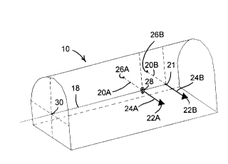
Fig. 2 illustrates the arrangement of the same mine heading 10 in accordance
to the present invention. Here, brackets 22A and 22B are mounted on the wall
of the
mine or tunnel and rods 24A and 24B are extended therefrom. Grade lines 20A,
20B
are obtained as extension of rods 24A, 24B by shooting a prism to the other
wall
where reflectors 26A, 26B are mounted to create lines perpendicular to the
reference
line 18. This reference line 18 is obtained by projecting a concentrated beam
26
located at the extremity of rod 24B, through a sighting device 28 located at
the
extremity of rod 24A and the spot 30 at the front of the mine heading 10 can
then be
marked by the same surveyor who set up the entire arrangement. The same
procedure
can be performed by a miner, unassisted.
Another view of the set-up of the present invention is shown in Fig. 3 where
it
is clearly illustrated how brackets 22A and 22B are mounted to the wall of the
mine
heading 10.
Rods 24A, 24B extend laterally from the brackets 22A, 22B, parallel to the
ground 11 of the tunnel, drift or ramp. These rods are positioned at
approximately
five meters from one another. The rods are extensible to a length of about
three
meters, although in some cases this may be longer when corners are being
surveyed;
in such cases a vertical stabilizing support may need to be provided at the
free end of
the rod. These rods 24A, 24B are normally obtained in 1 meter extensions with
a
8
CA 02270483 1999-04-30
removable level bubble mounted on the top and an adjustable section made
similar to
a range pole, so that the surveyor may set the appropriate length as required.
The rods
are also available in 5' ( 150 cm) lengths that are subsequently cut by the
surveyor to
the calculated lengths. Once the rods 24A, 24B are properly installed and
positioned
with respect to reflectors 26A, 26B, the reference line is established.
Then, the light beam transmitter 21 is mounted at the end the rear rod 22B and
a sighting device 28, such as a washer, is mounted at the end of the front rod
22A.
The light beam transmitter 21 should normally produce a beam that is <0.1 m at
200
m distance and have a range of at least 200 m. The light beam passes through
the
sighting device 28 to establish the reference line 18 and the light beam spot
30 on the
face of the mine tunnel 10 can thus be marked.
Fig. 4 provides a more detailed view of a preferred embodiment of rod
installation. As shown in this figure bracket 22, which in this case is an
equilateral
triangular steel plate, has holes 23 at its apexes through which anchors may
be
inserted so as to solidly fix the bracket to the mine wall. The bracket 22 has
a
three-axis joint 25 connected thereto so that the rod 24 may be adjusted in
its x, y, z
axial positions. Rod 24 is provided with extension means 27 so that its length
may be
adjusted as desired. The rods are also available in standard lengths that are
subsequently cut by the surveyor to the calculated lengths. At one of its
ends, rod 24
is provided with an attachment fixture 29 that enables it to be removably
attached to
the joint 25. A prism attachment 32 may also be connected to the joint 25. At
the
other end of rod 24 there is provided a connecting sleeve 31 through which a
light
beam transmitter 21 or a sighting device 28 can be connected to the rod; this
arrangement can thus be used either for the front rod 24A or for the back rod
24B as
required.
Finally, in Fig. 5 there is provided an illustration of a preferred embodiment
of
the 3-axis joint 25 which, in this case, is mounted within triangular bracket
elements
22A, 22B with holes 23A, 23B at the apexes being used for the attachment to
the
mine wall. The circular body 34 has a cylindrical protrusion 36 to which the
rod 24
may be connected. This body 34 is movable within the triangular bracket
elements
22A, 22B so as to be adjustable in three-axial directions, thereby permitting
9
CA 02270483 1999-04-30
adjustment of the rod in the x, y, z directions.
It should, of course, be understood that the invention is not limited to the
specific embodiment described above but that various modifications obvious to
those
skilled in the art can be made therein without departing from the spirit of
the
invention and the scope of the following claims.