Note: Descriptions are shown in the official language in which they were submitted.
CA 02271307 1999-OS-10
6032/065F
.... .. . .. .. ..
.. .. . .. . . . ..
. . . . . . . . . . ... ..'
.. . . : . ..
FROZEN PRECIPITATION ACC;UMUL~TIOfV ALERT S'f9TEiVl ~~ ~~
- FIELD OF THIE INVENTION
This invention relates to the field of winter a~~ ation hazards, and more
particularly to a system that detects and/~~r forecasts dangerous
accumulations of
frozen precipitation within a target area on the Earth's surface and generates
an
alert to indicate the need to remove frozen precipitation from aircraft and
runways
within the target area.
PROE3LEM
The accumulation of frozen precipitation on an aircraft prior to takeoff is a
significant factor contributing to the loss of lift and the increase in drag
during the
vulnerable moments during takeoff. Loss of lift and/or increased drag during
aircraft takeoff have been factors in at least 10 commercial airline takeoff
accidents
in recent decades. For example, the accumulation of as little as 0.8 mm of ice
on
the upper wing surface of an aircraft can result in about a 25% loss of lift
during
takeoff. Frozen precipitation in the context of the present discussion
includes, but
is not limited to, snow, ice, frost, sleet, freezing rain, and a mixture of
frozen and
liquid precipitation.
Existing techniques for detecting 2,n accumulation of frozen precipitation in
a target area and determining the need to remove frozen precipitation from
objects
in the target area rely heavily on visual inspections of the objects and the
local
weather conditions. At an airport, an airtr;~ffic controller may decide to
hold aircraft
at the gate of an airport terminal based on a regional National Weather
Service
(NWS) weather forecast in combination ~Nith local temperature readings,
outside
visibility estimates, and informal on-sii:e weather reports from other airport
personnel around the airport. Similarly, an airport manager may decide to
clear a
runway or begin or postpone de-icing and/or anti-icing operations based on the
same regional NWS weather forecast, local temperature readings, outside
visibility
estimates, and informal on-site weather rE~ports. Finally, a flight crew may
request
aircraft de-icing and ground crews may initiate de-icing or runway clearing
based
only on weather visibility and/or a visual inspection of the objects
themselves.
However, making safety decisions based on a regional NWS weather forecast, a
local temperature reading, and an outsider visibility estimate, is too
subjective and
V n !,'
6032/065F CA 02271307 1999-os-io
. . .... .. . ..
.. .. . . . .. . . .". .".
. . . . . . . . . . ... ..
potentially misleading for the level of safety :req~ired'o'f.mode~r~
'commercial.'
aviation.
_One problem with making informE;d decisions to remove frozen precipitation
from objects such as runways and grounded aircraft at an airport, is the lack
of
accurate meteorological indicators of frozen precipitation in the immediate
airport
target area. This is a particular problem for today's sprawling commercial
airports
if the meteorological sensors on which a regional NWS forecast is based are
located outside the immediate airport target area or only in a remote part of
the
airport target area. A winter storm front near an airport can create
distinctly
different and dangerous weather conditions for a runway at one end of an
airport
than for another runway at an opposite end of the airport. Another problem is
that
an outside visibility estimate during a frozen precipitation event is at best
only a
subjective measure of visibility and accumulation, and is a decidedly poor
measure
of the precipitation rate. Unfortunately, the present standard by which
decisions
are made by airport personnel to remove frozen precipitation from runways and
aircraft is based primarily on NWS visibility categories of light (S-),
moderate (S),
and heavy (S+) precipitation. These NWS visibility categories are unreliable
because small snowflakes or ice crystals often create an illusion of light
precipitation and large .snowflakes or ic;e crystals often give the illusion
of heavy
precipitation, and the density of the frozen precipitation cannot be
determined by
casual observation. Meteorological data available from the time of major
commercial airline takeaff accidents indicates that visibility varied widely
from good
to poor although the precipitation rates during each accident were
consistently high
up to or about 2 to 2.54 mmlhr. Thus, the wide variability in visibility at
the time of
each commercial airline accident versus the consistently high precipitation
rates for
each accident suggests that the present NWS visibility categories are
unreliable for
purposes of determining the need to remove frozen precipitation from runways
and
aircraft. Part of the reason for the wide variability in visibility for a
given frozen
precipitation rate is the observed order of magnitude variation in crystal
density for
a given snowflake size. Since visibility reduction due to a snowflake is
proportional
to the area of the snowflake and not thf~ density of the snowflake, wide
variations
in precipitation rates are possible for a given snowflake size due to
variations in
-2-
i~t~lEnlG~U ,;~';=~T
0032/065F CA 02271307 1999-OS-10
.... .. . .. ..
.. .. . . . ..
. . . . . . . . . . ... ..'
snowflake density. Further, surface temperature can~.ot'be used. a~. a
reaab~R.'
surrogate for snowflake density because snowflake density depends on the
crystal
type which is a function of in-cloud tempE~rature and supersaturation at the
location
where the crystal was formed, the degree of rimming which is a function of the
mass concentration of cloud droplets that the crystal encountered during its
fall to
the surface, and the degree of crystal aggregation which is a function of ice
crystal
concentration aloft in conjunction with the presence of dendritic crystals and
the
closeness to the 0°C isotherm. Without prier knowledge of the above
factors the
precipitation rate of frozen precipitation is impossible for an observer to
determine
yet it is a significant factor contributing to aircraft takeoff accidents.
Another problem is the conflict between commercial aviation economics
versus passenger safety. Failure to de-ice or anti-ice an aircraft, or the
result of
exceeding the hold-over time following de-icing or anti-icing operations, can
contribute to the likelihood of an aircraft takeoff accident. For this reason
alone, the
airline customer expects that any trace of frozen precipitation should be
removed
from runways and aircraft as often as pc>ssible prior to every flight during a
winter
storm. On the other hand, unnecessarily de-icing or anti-icing a single
aircraft can
cost thousands of dollars in wasted materials and schedule delays. Further,
unnecessarily closing a runway for clearing, de-icing andlor anti-icing can
cost tens
of thousands of dollars to the airport, and airlines using the airport, due to
schedule
delays and/or flight cancellations nation 'wide for domestic flights alone.
Therefore
there is a strong economic and safety incentive for more accurate and reliable
meteorological indicators so that airport: personnel can decide when or if
frozen
precipitation must be removed without compromising safety.
For these reasons it is a problem to provide airport personnel with highly
accurate, localized, real-time, 0-30 minute meteorological reports and
forecasts for
use in identifying a dangerous accumulation of frozen precipitation within an
airport
target area.
Existing meteorological systems Include one disclosed in U.S. Patent No.
5,028,929 which comprises an airborne icing hazard detection system for
aircraft
that uses dual radar beams which are transmitted into a cloud located in front
of the
aircraft. The reflected signals at each of the two frequencies are compared
and
-3-
,r, .~..
~fE-~ ~~~~; '' ~-
CA 02271307 2003-02-26
72956-72
processed to determine the presence, amount and locations of
liquid water in the cloud. In addition, European Patent
Application No. EP-A-0 622 939 discloses a meteorological
workstation that is connected to a plurality of
meteorological information sources that measure at least one
meteorological indicator and detect a meteorological
structure using radar. However, this system does not
include precipitation rate sensors or address the issue of
icing detection for aircraft.
SOLUTION
The above identified problems are solved and an
advance achieved in the field by the frozen precipitation
accumulation alert system of the present invention, The
frozen precipitation accumulation alert system detects
and/or forecasts a dangerous accumulation of frozen
precipitation within a target area on the Earth's surface
and generates an alert to indicate the need to remove frozen
precipitation from aircraft and runways within the target
area.
The frozen precipitation accumulation alert system
comprises a method and apparatus for measuring at least one
meteorological indicator in at least one measurement
location proximate to the target area, detecting
meteorological phenomena by radar data from a meteorological
radar over a region that includes the target area,
determining forecast based on meteorological phenomena and
at least one of the meteorological indicators, and
determining a surface accumulation alert based on the
surface accumulation forecast. The measuring of at least
one meteorological indicator includes a method and apparatus
for quantifying a precipitation rate of frozen precipitation
over time wherein the precipitation rate is one of the
4
CA 02271307 2003-02-26
72956-72
meteorological indicators. The system also includes a
method and apparatus for generating a view in human readable
graphic form indicative of the target area and user selected
ones of the meteorological indicators, the meteorological
phenomena, and the surface accumulation forecast.
One broad aspect of the invention provides a
ground-based frozen precipitation accumulation alert system
for forecasting dangerous accumulations of frozen
precipitation within a target area on an Earth's surface,
said system comprising: means for measuring at least one
meteorological indicator in at least one measurement
location on the Earth's surface proximate to said target
area; means for detecting, using radar data from a weather
radar, the presence of a meteorological phenomena located
over a region that includes said target area; and means for
determining a frozen precipitation accumulation forecast
based on said meteorological phenomena and said at least one
meteorological indicator.
Another broad aspect of the invention provides a
method of operating a ground-based frozen precipitation
accumulation alert system for forecasting dangerous
accumulations of frozen precipitation within a target area
on an Earth's surface, said method comprising the steps of:
measuring at least one meteorological indicator in at least
one measurement location on the Earth's surface proximate to
said target area; detecting, using radar data from a weather
radar, the presence of a meteorological phenomena located
over a region that includes said target area; and
determining a frozen precipitation accumulation forecast
based on said meteorological phenomena and said at least one
meteorological indicator.
4a
CA 02271307 2003-02-26
72956-72
BRIEF DESCRIPTION OF THE DRAWINGS
FIG. 1 illustrates an airport configuration with a
frozen precipitation accumulation alert system in block
diagram form;
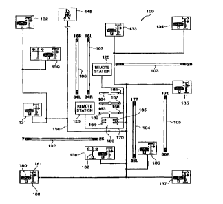
FIG. 2 illustrates system connectivity for the
frozen precipitation accumulation alert system in block
diagram form;
4b
6032/065F CA 02271307 1999-os-io
.. .. .. ..
.: ': . . .: . . .". .
.'. . . . . . . . ... ..'
FIG. 3 illustrates the frozen precipitation: a~cilfiul~tiort:a~ect' sys~o"~
operational steps in flow diagram form; and
FIG. 4 illustrates a user selectablE~ view example in block diagram form.
DETAILED DESCRIPTION
Airport Configuration Layout - F1G. 1
FIG. 1 illustrates an airport configuration referred to herein as target area
100. This and any other configuration illustration and any accompanying
discussion are for purposes of example only and are not limitations on the use
or
ability of the frozen precipitation accumulation alert system. Target area 100
includes east-west runways 102-103, nor':h-south runways 104-107, and an
airport
terminal complex 160. Airport terminal complex 160 includes a main terminal
161
and remote terminals 162-164. The size of target area 100 includes tens to
hundreds of square kilometers although there are no limits or requirements for
the
size of a target area.
Sensor stations 130-139 are located proximate to and throughout target area
100 forthe purpose of measuring real-tim~s meteorological conditions at the
Earth's
surface within the target area. The community of sensor stations 130-139 are
commonly referred to as a sensor grid, although the sensors need not be in any
specific grid configuration. Each of the sensor stations 130-139 are
interconnected
by a first communications carrier 150 to a processing station 165 in the main
terminal 161. The location of processing station 165 can be anywhere within or
outside of target area 100. A sensor stati~un includes at least a
precipitation gauge
such as snow gauge 180 which me<~sures the liquid equivalent of frozen
precipitation accumulation. An anemomEaer and wind vane combination, such as
anemometer 181, typically accompanies each snow gauge to measure wind speed
and wind direction. Similarly, a thermometer, hygrometer, and/or barometer are
also typically located at each sensor station to measure temperature,
pressure, and
humidity. The set of measurements including, but not limited to, temperature,
pressure, humidity, wind speed, wind dirE~ction, and precipitation
accumulation are
more generically referred to as meteorological indicators.
A snow gauge is key meteorological indicator for the frozen precipitation
accumulation alert system. A snow gauge is an apparatus designed to measure
,;.d,. -~~ _~-; ,
6032/065F CA 02271307 1999-os-io
.... .. . .. ..
. .: . . . .. . . .". .
. . . . . . ... ..
the liquid-equivalent accumulation of precipitatioriin vi~inirerconditions.
Pre'cipitatioh.'
accumulates in a container or bucket in the snow gauge at the same rate and in
the
same quantity a~ the precipitation falling in the immediate area. The
accumulation
container is charged with an anti-freeze solution such as ethylene glycol or a
mixture of glycol and methanol, or any similarly functioning solution, to
dissolve the
solid precipitation and prevent freezing of the liquid contents. A layer of
oil helps
retard evaporation from the solution. The weight of the accumulated
precipitation
is converted into a corresponding depth with resolutions at or about 0.2 mm or
less.
A shielding apparatus may be necessary to reduce air-flow distortion around
the
orifice of the snow gauge and to optimize the sampling potential for the snow
gauge. Types of snow gauges available in the industry include, but are not
limited
to, the Universal gauge by Belfort, and the ETI gauge by Environmental Test
Instruments. The Universal gauge is the preferred snow gauge and the gauge
used by the NWS. Shielding apparatus includes, but is not limited to, the
Nipher
shield by the Canadian Weather Servic?, the Alter shield by the NWS, and the
Wyoming shield by the University of Wyoming.
Additional meteorological sensing apparatus at each sensing station can
include, but is not limited to, a visibility gauge 182 as illustrated in
meteorological
sensor stations 138-139. Visibility gauge 182 uses a laser sensor facing a
focusing
hoop to provide quantitative visibility feedback from either of the sensor
stations
138-139.
The number of sensor stations reduired for a target area is a function of the
size of the target area, the level of meteorological resolution desired, and
the
existence of any object within the target area requiring special attention.
For target
area 100, runways 103-107 are important objects that require well thought out
sensor station placements adjacent to the runways because the amount of frozen
precipitation accumulating on or near a runway can reflect a dangerous
accumulation of frozen precipitation on aircraft in the immediate area waiting
to use
the runway. Sensor locations near preferred takeoff taxi routes are also
desirable
and provide highly relevant information for de-icing crews. Also, locating
sensors
in at least one position upstream from the prevailing winter storm patterns
relative
to target area 100, can provide highly relevant information regarding
approaching
_Ei_
AMENDED SHEET
CA 02271307 2003-02-26
72956-72
precipitation. Generally, the more sensor stations that are
placed within a target area the better the resulting
meteorological resolution. However, a minimum of three
sensor stations are needed to generate adequate accumulation
information. For the purposes of this discussion any
reference to a sensor station means a sensor station that at
least includes a snow gauge and typically also an anemometer
and wind vane.
At least one weather radar 145 is positioned to
provide radar coverage of target area 100. The location of
weather radar 145 is typically a remote location far enough
from target area 100 so that one radar can sweep the entire
target area. Weather radar 145 is used to detect and track
meteorological phenomena at elevations less than or about
1 km that directly influence surface conditions in and
around target area 100. A NEXt generation RADar (NEXRADTM)
is a typical weather radar used to collect data indicative
of meteorological phenomena at 1 km or less elevations.
Weather radar 145 collects radar data on a beam by beam
basis across target area 100 to reveal meteorological
phenomena that is approaching or retreating from target area
100. Meteorological phenomena is revealed when the radar
signal is reflected off the meteorological phenomena. The
reflected signal is captured by the receiving antenna of
weather radar 145 as radar data, also known as radio signal
reflectivity data. Reflectivity data can be used by itself
for the identification of meteorological phenomena alone or
as part of a Z-S relationship calculation where Z is the
radar reflectivity factor and S is a snowfall or frozen
precipitation rate as determined by a snow gauge. The Z-S
relationship is used to determine a projection of future
radar reflectivity values using storm-tracking techniques
that determine precipitation rate forecasts. More
7
CA 02271307 2003-02-26
72956-72
specifically, the Z-S relationship is Z=aSb, where a and b
are determined through regression fits to the data.
Standard storm-tracking systems available in the industry
include, but are not limited to, a winter storm version of
the Thunderstorm Identification, Tracking, Analysis, and
Nowcasting (TITANTM) system by the National Center for
Atmospheric Research (NCAR) in Boulder, Colorado, TREC, and
the Radar Echo Prediction (REP) system by NCAR.
Temperature is another important meteorological
indicator factored by the frozen precipitation accumulation
alert system. The temperatures observed during
*Trademark
7a
6032/065F CA 02271307 1999-os-io
.... .. . .. .. ..
. .: . . . .. . . . . .
~ ~ 1 ~ ~ ~ . . . . ~ ~~. ~.
commercial aircraft takeoff accidents were quite ~3rarrY~ irl.ttie~caT~ge
f~'~r~.about,25',~'
F to 31 ° F. For this reason temperature readings at each sensor
station 130-139
across target area 100 are important
Wind enhanced precipitation accumulation is another important
meteorological indicator factored by the frozen precipitation accumulation
alert
system. Since the accumulation of frozen precipitation on a surface is
determined
by the compor; ~t of the precipitation's motion perpendicular to a surface,
the mass
flux of frozen precipitation to a surface is written as:
MassFlux = PS = IWC ~ VT
= IWC (Vrcos(6) + Hwspd ~ sin(6) )
wherein P is the liquid equivalent precipitation rate, IWC is the ice water
content of
the frozen precipitation, V is the average terminal velocity of the frozen
precipitation, and Hwspd is the horizontal wind speed. Equation (2) factors
the
perpendicular component of both the frozen precipitation terminal velocity
average
V and the horizontal wind speed Hwspd for a mass flux to a surface oriented at
angle 8 to the horizontal. If the surface is oriented horizontally, then
equation (2)
indicates that the mass flux equals the IWC of the frozen precipitation times
V.
However, if the surface is inclined from the horizontal as is the case for an
aircraft
wing, then the horizontal wind increases the mass flux of snow to the inclined
surface by a factor proportional to sin(8) times the wind speed. For a typical
aircraft
wing, 8 is about 10° and results in the following equation for a liquid
equivalent
precipitation rate:
PS=IWC~(0.98uVT+0.174~Hwspd)
Equation (4) illustrates the enhancement factor over the accumulation on a
horizontal surface which is only a function of the horizontal wind speed
Hwspd, the
frozen precipitation terminal velocity average V, and the angle 8.
,,~ ~~ ~'f .4-I . s"~Cr
J1f~Ill_1'wV ~J~LR
6032/065F CA 02271307 1999-os-io
.... . ..
.. . . .". .. . . . '. .' .
. . . . . . . . . . ... ..
.. . : .
H~nisp ~ ~. .. ..
Ef -- PS (6) I PS (B = 0) cos (8) ~ sin (8) ( VT __ I ~4~
Processing station 165 in main ter urinal 161 connects sensor stations 130-
139 and weather radar 145 by way of first communications carrier 150.
Processing
station 165 also connects monitoring s!:ations 120, 125, 166-168 by ~:vay of a
second communications carrier i 7 0. Depending oi~ the airr:ort terminal
configuration one of the monitoring stations 166-168 may be an airport control
to~Ner and processing station 165 may include a monitoring station or ~a~~e ~.
monitoring station located elsewhere within main terminal 161.
One of the monitoring stations 166-168 may be used by an airport manager
to monitor precipitation accumulation si:atus and oversee aircraft de-icing
and
runway clearing operations. Other of the monitoring stations 166-168 may be
used
by ground crews at gates in remote terminals 162-164 to determine the need to
de-
ice or anti-ice aircraft at the gate. Although de-icing or anti-icing at the
gate is not
the only or last opportunity to remove frozen precipitation from an aircraft,
gate de-
icing or anti-icing is common at many airports that lack remote de-icing and
anti-
icing stations near takeoff runways. De-icing is the processes of applying a
Type
I chemical to the exterior of aircraft to remove frozen precipitation
therefrom. Anti-
icing is the process of applying a Type II chemical to the exterior of
aircraft to
prevent frozen precipitation from accumulating thereon.
Ground crews at remote monitoring stations 120 and 125 also monitor
meteorological indicators from the frozen precipitation accumulation alert
system
to determine the need to de-ice or anti-ice aircraft immediately prior to
aircraft
takeoff. Remote de-icing stations 120 and 125 are located at the beginning of
takeoff runways 103 and 106-107. Posit oning the remote de-icing stations at
the
beginning of a runway is useful because a previously de-iced aircraft may have
been away from its terminal gate from tens of minutes to more than an hour
prior
to being cleared for takeoff. Depending on the amount of time and the
precipitation
rate since the most recent de-icing operation on the aircraft, a safe holdover
time
for a present precipitation rate may have been exceeded thereby creating a
serious
safety hazard forthe aircraft and its passE:ngers. Without a remote de-icing
station
-c~_
6032/065F
CA 02271307 1999-OS-10
.... .. ..
.: . . ". .: .". . . .
. . . . . . . . . . . ... ..'
safety hazard for the aircraft and its pas:~engers~ Withocrt a feimotei~e
:Sing st~ticr~'
an aircraft that has exceeded its holdover time would have to return to the
terminal
gate far additional de-icing thereby creating further airline scheduling
delays. In
general, airport personnel use the precipitation accumulation total, the
present
precipitation rate, and projected precipitation total and accumulation rates
in the
next 0-30 minutes, to coordinate removing accumulated precipitation from
rur~~ways
and the de-icing andlor anti-icing operations. More precisely. it is the
liquid
equivalent of frozen precipitation accurnulation that provides the most
accurate
meteorological indicator for the frozen precipitation accumulation aier'
system.
The number of snow gauges and availability of additional meteorological
sensing apparatus and techniques are directly related to the size of the
target area
covered, the quality of data gathered from the sensor grid, and the ability of
the
system to report real time and/orforecasl:ed weather information. Table I
illustrates
the relationships between sensors, targ~Jt area, and resulting reports.
TABLE I
System Components Scope ~of System Resulting Report
< 3 snowgauges Discrete points onlyReal time view
>_3 snowgauges Full target area Real time view
>_ 3 snowgauges Full target area Real time
and radar qualitative view
>_3 snowgauges, radar,Full target area Real time
and Z-S quantitative view
>_3 snowgauges, radar,Full target area Real time and full
Z-S, and tracking forecast quantitative
algorithms . view
Referring to Table I above, a sensor grid having less than 3 snow gauges
can only provide real-time accumulation data for discrete points only rather
than for
an entire target area. Alternatively, a sensor grid having at least 3 snow
gauges
can provide real-time accumulation data for a target area because the snow
gauges
can at least be triangulated within the target area. Therefore, at least 3
snow
-10-
CA 02271307 2003-02-26
72956-72
gauges is a critical threshold number of sensor stations for
providing any useful alert system data.
Adding a weather radar to a sensor grid is a
critical threshold for providing more robust data for the
alert system. Having at least 3 snow gauges in a sensor
grid in combination with a weather radar can provide a real-
time qualitative view of a target area. Similarly, having
at least 3 snow gauges in a sensor grid in combination with
a weather radar and a Z-S relationship calculation, can
provide a real-time quantitative view of a target area.
Finally, 3 snow gauges in a sensor grid, a weather radar, a
Z-S relationship calculation, and storm tracking systems can
provide a real-time and full forecasted quantitative view of
a target area.
System Connectivity - FIG. 2
FIG. 2 illustrates system connectivity for the
frozen precipitation accumulation alert system in block
diagram form. For purposes of illustration there are n
independent and continuously operating sensor stations 130-
lxx represented in FIG. 2. Data from sensors 180-181
through 205-206 in sensor stations 130 through lxx is input
in analog form to respective analog to digital converters
210 through 211. The digitized data from analog to digital
converters 210-211 is input to respective data loggers 215
through 216 to time and date stamp the data, encode sensor
identification for the sensor station from which the data
originated, and record the data. A data logger is a
Personal Computer (PC) based computing device or an
equivalent device capable of operating independently in the
manner described herein. In the preferred embodiment a data
logger is an Intel based PC running a UNIXTM operating system
and storing data as an American Standard Code for
11
CA 02271307 2003-02-26
72956-72
Information Interchange (ASCII) data file. Data collected
by data loggers 215 through 216 operate continuously to make
real-time data available to processor 230 from sensors 180-
181 through 205-206 in about 1-minute time increments.
Whether radar 145 sends radar signals and collects
radar reflectivity data on a beam-by-beam basis.
Preprocessor 220 re-samples the data into Cartesian
coordinate system based grids for each Plan Position
Indicator (PPI) scan of a specific elevation. The Cartesian
coordinate system based radar data is recorded by
preprocessor 220 with a date and time stamp that reflects
either the time a complete scan was received or the time
data from each pulse was received during
*Trademark
lla
6032/065F CA 02271307 1999-os-io
.... .. .. ..
.. .. . . . .: . . .". .
. . . . . . . . . . . ... ..
the scan as the radar antennae rotated. The C~rtebian.EOOrc~inateayste'm
based.'
data facilitates generate a plan view, also known as a polar view, in addition
to
simplifyjng the generation of an updated view. The plan view is a constant
volume
view of a specific elevation over target arE:a 100 called a live Cartesian
volume that
is continually updated to minimize the mean age of the data. The typical mean
age
of data made available at the completion of an entire scan is about 1-3
minutes
maximum. As an alternative to purchasing and operating a ~,veather radar to
collect
reflectivity data the desired data can be purchased from any ,oarty owning
and~'or
operating a weather radar in a region that includes the target area of
interest.
Processor 230 is a PC or equivalent computer system compatible with data
loggers 215 through 216 and monitoring stations 166-168. Processor 230 is
located in processing station 165 and is designed to continuously poll each
data
logger 215 through 216 and radar preprocessor 220 using a daemon background
process to collect updated data from respective ASCII files across target area
100
by way of first communications carrier 1 ~i0. First communications carrier 150
can
be a wire or wireless transmission medium such as radio or telephone
transmission
mediums using a Transmission Control Protocol/Internet Protocol (TCP/I P) or
other
suitable protocol. First communications carrier 150 can also be used to
transmit
information to each sensor in sensor stations 130-139 for purposes including,
but
not limited to, coordinating sensor initialization and/or calibration
procedures for all
or any one of the sensors across the sensor grid within target area 100.
Data from each sensor station '130-139 is ingested and processed by
processor 230 to generate a liquid equivalent of frozen precipitation, a
cumulative
precipitation total, and a time derived precipitation rate for each snowgauge
in
target area 100 as well as for target area 100 as a whole. The total
accumulated
precipitation and the precipitation rate for target area 100 as a whole is
distance
weighted to accommodate simultaneous c':ata updates from snow gauges at
varying
distances throughout target area 100. Snow gauge data may also be smoothed to
remove extreme readings produced by an individual snow gauge. Extreme
readings for a snow gauge can occur if precipitation builds up on the edge of
a
snow gauge and the large buildup suddenly falls into the gauge under the
precipitation's own weight. Updated mesonet data, otherwise known as
Aiv~ti'~DED SHEET -12-
6032/065F CA 02271307 1999-os-io
.... .. .. .. ..
.: .. . .: . . . ..
:'. . . . . . . . . . ... ..'
meteorological indicators, fortemperature, humi~Jity:wii~d'sp~d and.wi~d
dire~tio~~'
are processed by processor 230 to generate a present reading for each sensing
devicelndividually in target area 100 as vvell as for the target area 100 as a
whole.
Processor 230 transmits by way of the second communications carrier 170,
the raw data componenla necessary for monitoring stations 120, 125, 165, and
166-168 to generate user defined views ~:f the collected data. Users of the fr
ozen
precipitation accumulation alert system in an airport situation t~.;pically
vie:v the
collective meteorological data a't !ccations including remote de-icing
monitoring
stations 120 and 125, the airport managers monitoring station n the
~roc;:ssing
station 165 of main terminal 161 or other remote terminals 162-164, and any of
the
additional monitoring stations 166-168. Each monitoring station can generate a
custom view of the sensor station d<~ta that facilitates at-a-glance viewing
necessary for each user to make decisions relating to the need to remove
frozen
precipitation from objects within target area 100.
Operational Steps - FIG. 3
FIG. 3 illustrates the operational steps for the frozen precipitation
accumulation alert system. The system ~~tarts at step 302 and proceeds to
system
initialization at step 305. System initialization includes, but is not limited
to,
powering up or otherwise restarting a sensor or other system component to an
operational state, either individually or ;substantially at the same time as
other
sensors and/or system components. When a sensor and/or component is
operational, sensor calibration occurs at step 308. Sensor calibration
establishes
a baseline sensor reading for like sensors across target area 100 so that like
sensors will report data that is accurate relative to all other like sensors
across
target area 100.
A continuous process begins following the sensor calibration at step 308.
At step 310, each sensor in the sensor grid within target area 100 takes
continuous
and independent meteorological readings. of the ambient environment and the
data
from the meteorological readings is stored by the respective data loggers 215
through 216. Operating substantially concurrently with step 310 is step 313
where
weather radar 145 continuously and independently receives radar data reflected
from meteorological phenomena in the atmosphere and the radar data is recorded
-13-
,~~riE',OEC ,. ._~_
;.;, ~ _
6032/065F CA 02271307 1999-os-io
.... .. . .. .. ..
.. .. .. . .. . . . ..
. . . . . . . . . . . ... ..
in preprocessor 220. At step 315, processor 2~0 conf~xio~sly
andaridependen~~c'
polls for updated sensor data and radar data collected in steps 310 and 313.
Updated data collected at step 315 due 1o sensor polling by processor 230 is
used
by individual monitoring stations across target area 100 to generate user
defined
views of the data collected from target area 100 at step 318.
The view generated at step 318 is updatable as new data arrives from the
continuous sensor polling and radar dai:a collection by processor 230. The
view
generated at step 318 is user defined and user controlled based on the
underlying
capabilities provided by standard windo~NS software that is readily available
in the
commercial PC softwarE; industry. A view, meaning a set of data displayed in a
screen configuration, can include any individual one or any combination of
data in
real-time view form at step 320 or in forE~cast view form at step 325. In
either the
real-time view form or the forecast view form or some combination thereof, an
audible or visual frozen precipitation accumulation alert is generated at step
328 to
warn the user of the frozen precipitation accumulation alert system of weather
conditions that presently call for removing precipitation or that are expected
to
require precipitation removal in the future. User defined alert parameters can
be
manually set or the system can automatically set the alert parameters base on
an
analysis of past airline takeoff accident weather conditions. In addition, an
analysis
of past airline takeoff accident weather conditions can take aircraft type and
loaded
weight into consideration to set alert parameters for specific aircraft types.
Given the types of view available to the user, the details of what data a user
chooses to view and in what specific screen configuration the data is viewed
are
subject to the user's needs. User control over screen configuration is
designed with
three guiding principles in mind including: 1 ) providing the user with simple
controls
to arrange any specific screen configuration; 2) providing the user with
maximum
information at a glance; and 3) providing information that does not require
special
meteorological knowledge or at most requires minimal training to interpret
because
the alert system is designed to automatically notify the user when dangerous
conditions presently exist or are likely tc exist at some time in the future.
Any user selected view can be altered by further user selection as desired
by the user. Thus the view flexibility accommodates needs and interests of a
._ -r~ i 4
6032/065F CA 02271307 1999-os-io
.... .. . .. .. ..
.. .. . . . .. . . . . .
. . . . . . . . . . . ... ..
variety of user perspectives from individual gro~nd:cre~cs fo.air
tr~f~ic'rdntroJler~..'
For example, airport personnel need to know both the recent precipitation
accumulation, present precipitation rate, and projected accumulation in the
next 0-
30 minutes to coordinate removing the precipitation accumulation from runways
and de-icing and/or anti-icing operations. More importantly than determining
precipitation accumulation, however, th~~ frozen precipitation accumulation
alert
system determines the liquid equivalent of accumulated frozen precipitation
which
provides the most accur<~te information needed to determine the need to remove
frozen precipitation from aircraft and/or runways.
User Selectable View - FIG. 4
FIG. 4 illustrates a user selectable view example 400 in block diagram form.
The view example 400 includes a primanr view 402 with secondary views 406-408.
The administration and setup for the type and location of the primary and
secondary views, are user defined and selectable by standard pointer device
menu
selection and window sizing techniques known and available in the industry.
The
user can define the primary and secondary views to satisfy the type of
information
needed for their duties at their location.
Primary view 402 includes a multiple grid data view of present and forecast
reflectivity data that can range in time ~~nywhere from about 30 minutes past
to
about 30 minutes future. The multiple grid data view is color coded to
indicate
various precipitation rates across target area 100 using rate indicators 409-
415.
Precipitation rate indicatars 409-415 illustrate a visual precipitation rate
range from
light 409 to heavy 415 precipitation. Audio and/or visual alert indicators are
generated in response to the precipitatic>n rate indicators. Geographic
reference
overlay 403 show the airport terminal area and runways on top of the grid
data.
Snow gauge icon 404 can also overlay primary view 402 to show sensor locations
and individual real-time precipitation rates at each location. Primary view
402 can
also be overlaid by other data including, but not limited to, storm motion
vectors,
temperature variations, precipitation rates for selected snow gauges, and wind
vectors. Users of primary view 402 can select between three preset spatial
domains also known as zoom levels or view levels 452. Selecting a view level
452
zooms into or away from selected areas within or surrounding target area 100.
-15-
6032/065F CA 02271307 1999-os-io
.... .. . .. .. ..
.. .. . . . .. . . . . .
... . . .. . . .. ... ..
Start/stop control 451 starts and stops the access andlordisplay
of~'efPe~~ivity.data.'
Loop speed control 450 increases and decreases the time delay in which primary
view 402 is updated. Additional information that a user can add by
administration
and setup to their primary view 402 includes, but is not limited to,
displaying real-
time wind barbs indicative of wind direct'~on and speed across target area
100.
Secondary view 405 is a graphic; illustration of a precipitation graph 406
having a precipitation accumulation and reflectivity axis 420 relative to a
time axis
421. The data plotted on graph 406 ranges from a start time 422 to a future
time
423 with the present time 424 in between. Time on the graph can be color coded
to show age of the data. The graph 406 shows a precipitation accumulation at a
specific point in target area 100. The specific point in target area 100 is
selected
by a user delivering a cursor command in primary view 402. A cursor command is
typically delivered by manually positioning a movable cursor in the desired
location
on primary view 402 and activating a switch on a cursor control device in a
manner
well known in the PC computing industry. By delivering a cursor command in the
immediate area of a snow gauge such as~ snow gauge 404 in primary view 402 the
precipitation graph 406 will display accumulation data from snow gauge 404. By
delivering a cursor command in an area of primary view 402 that is a
configurable
distance from any snow gauge, precipitation graph 406 will display the lowest
elevational planes of radar data from weather radar 145 as the basis for the
plot.
The precipitation graph 406 can be used to determine the total precipitation
accumulation on an aircraft that is near a specific snow gauge for a period of
time.
Secondary view 407 is a text graphic illu~~tration of a precipitation rate as
recorded
in real time by each sensing station 130-139. Each line in secondary view 407
is
a specific sensing station 130-139 that is updated individually as new real-
time data
is available from each individual sensing station. Secondary view 408 is a
text
graphic illustration of average mesonet d~~ta from sensing stations 130-139
across
target area 100. The data includes average temperature 440 in degrees
Fahrenheit and Celsius, average humidit~~ 441 in percent, average wind speed
and
direction 442 in knots, meters/second, and degrees, and average atmospheric
pressure 443. Additional types of secondary views include, but are not limited
to,
a time series plot that illustrates the change in precipitation accumulation
or general
-16-
~ ;.~. l .,- ;
6032/065F
CA 02271307 1999-OS-10
.... .. . .. .. ..
.. .. . . . .. . . . . .
... . . .. . . .. ... ..
weather conditions for all or any one of the sensor locations ancta real-time
text
based view of the most recent NWS ob~~ervations of the target area and
vicinity.
Sumrr~ary
The frozen precipitation accumul;~tion alert system of the present invention
includes a method and apparatus for measuring real-time meteorological
indicators,
determining liquid equivalent precipitation rates for present and future
precipitation,
and generating a view of precipitation data for a user.
~;.,ar .;-,,: . -'17-