Note: Descriptions are shown in the official language in which they were submitted.
CA 02279528 1999-08-03
WO 98134166 P~T/IB98100366
COMMUNICATION BASED VEHICLE POSITIONING
REFERENCE SYSTEM
BACKGROUND OF THE INVENTION -w
1) Field of the Invention
The present invention relates to a system for
identifying the location of a vehicle, and more
particularly, to a vehicle positioning reference system.
2) Description of the Prior Art
Until recently, identifying the location of a
train on a train track was an inexact science.
Specifically, a train track was divided into fixed sections
known as blocks. Once a particular train entered a block,
no other trains could enter that block since the exact
location of the train was unknown.
The "fixed blocks" can vary in length from
hundreds of feet to miles on a particular track. In many
instances, the fixed block arrangement adversely affects a
train's schedule by preventing a train to enter a block
even though it is a safe distance from the next closest
train that just happens to be located in that block.
Recently, the concept of a "moving block" has
been proposed. A moving block system is a dynamic system
which creates an imaginary space or block that moves along
with a particular vehicle as it travels along a track where
no other train or vehicle may enter that space. The length
of the moving block depends on various characteristics,
such as train speed, train braking ability, etc. A simple
example of a moving block is a space which extends one
hundred feet in front of and one hundred feet behind a
particular train. Through appropriate communication
devices and computers, the appropriate safe distance
between trains can be continuously calculated and this saf a
distance can then be identified as the moving block that
moves along with the train. The length of the moving block
varies as the operating parameters of the train change.
A train system implementing the moving block
system requires an onboard computer for each train and one
or more wayside computers to communicate with the trains.
A problem in implementing this moving block technology into
w..r. .., ~ n.,r .. .,, n.w.m, ,.. ., , .,.. . .. , , . ..,. . , ..~..,. . ..
.,
LL:. iJ~..~.~Jw~~f.. r.~~ ,.l"1
.._ . _.' ~~~_~~. -~""~_.CA 02279528 1999-08-03 , ~-,- ~ ~ , ." ,. ,. , ,
- 2
PCT/IB98/CC365
large scale train systems is the size of the cornput.ers
necessary to operate and cozmT~unicate to the trains.
S Another major problem in a train system, be it a subway
train system or a large scale interstate train system, is
how to identify the location of the train. Eac:~ t=gin
system identifies a vehicle location differently. There-
fore, a problem exzsts in automatic r_rain control eystents
to as to hew train positions can be ide~ztified universally,
be it in a New York subway or in a train system i~r a
txain traveling across the United States.
Therefore, it is an object of the.present invention
_ to pro~.~=de a a ~ivexsal communication based vehic~.e pesi
1S tinning reference system.
It is a=other object of the pr°sent invention to
provide a vehicle positioning system that car_ operate
through a plural~.ty of computers rather than one central
computer.
SUMMARY OF T~:F I ~~1'_'I0~1
The press~t ~.nvent'_cn relates t~c a method for con-
trolling an aatomatsd controlled vehicle along a vehicle
oath coc~prising the steps of:
a) pro~c~iding a vehicle path;
b; providing a vehicle on said vehicle
path;
c) dividing said vehicle path into
0 segrnerts t at contain a portion of
said vehicle pat:;
d) identifying each of. said segments by
a cr~aracter string that identifies
characteristic information, said
characteric information comprising:
(l) a maximum speed permitted on the
segment;
tii) a segment grade;
AMENDED SHEET
kC:\. \o',:I.I'\-v11 I.:W III:', n.; ~;s- L_;I_s : ~s ,:~ . ~:si ~c~ :>y:mn r~
-,.s;r rs:s _:s:l;ol~ln:>:a is
- ~~_ . _ ~~~J.~~ ~ ~ ~~,~,~~LCA 022'79528 1999-08-03
23
ivii) a segment cur:ature; and
(iv) a segment length whexein
said characteristic information is
constant throughout said se3mertt a:rd
e) utilizing said charactistic informa-
tion to automaticalljr control said
vehicle on said vehicle path.
The cnaracterist:~c features pro°~ide information
which is constant throughout eacri individual segment.
This segment identifier provides all of the pertinent
constant information for the ent_re length of the aeg-
ment, such as segment grade, maximum segment speed and
track curvature. Thus the segment identifies has only one
to be Zooked up when the vehicle enters a particular
~5 segment. Thib leads to a substantial reduction in corapu-
t i:~g t ime .
~IvI~N'DED SHEET
CA 02279528 1999-08-03
WO 98/34166 PCTIIB98100366
BRIEF DESCRIPTION OF THE DRAWINGS
Fig. 1 is a top plan view of a vehicle track and
a vehicle car, in phantom, traveling along the vehicle
track;
Fig. 2 is a top plan view of a map showing the
vehicle track and the vehicle car shown in Fig. 1;
Fig. 3 is a portion of a map shown in Fig. 2;
Fig. 4 is a portion of a map shown in Fig. 2;
Fig. 5 is a portion of a map shown in Fig. 2;
Fig. 6 is a portion of a map shown in Fig. 2;
Fig. 7 is a side elevational view of a vehicle
car traveling on a track segment;
Fig. 8 is a schematic view of a map made in
accordance with the present invention;
Fig. 9 is a schematic view of a gauntlet portion
of track for travel by a vehicle;
Fig. 10 is a schematic view of a cross-over
portion of track for travel by a vehicle;
Fig. 11 is a schematic view of a scissor cross-
over portion of track for travel by a vehicle;
Fig. Z2 is a schematic view of an interlaced
switch portion of track for travel by a vehicle;
Fig. 13 is a schematic view of a slip switch
portion of track for travel by a vehicle;
Fig. 14 is a schematic view of a three position
turn table for use in a rail system to rotate a vehicle to
a number of different tracks;
Fig. 15 is a schematic view of a two position
torn table for use in a rail system to rotate a vehicle to
a number of different tracks;
Fig. 16 is a schematic view of a three position
transfer table for moving a vehicle to a number of
different tracks; and
Fig. 17 is a schematic view of a portion of track
representing a rail station.
- 3 -
CA 02279528 2002-O1-24
~.
DESCRIPTION OF THE PREFERR»1 E("BODII'~NTS
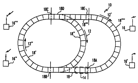
Fig. 1 shows a vehicle track 10, such as a train track,
defined by a plurality of paths 12, 12' and 12 " . A vehicle car
14, such as a train car, is adapted to travel on the vehicle track
10. A plurality of computers 16, 16', 16 " and 16 " ' are provided
to comnuni.cate with the vehicle car 14. Preferably, the computers
16, 16' , 16" and 16" ' and the vehicle car 14 cc~anunicate via
radio transmitters and receivers. Also, the computers 16, 16',
16 " and 16 " ' are adapted to communicate with each other. As
shown in Fig. 1, the vehicle track 10 is also divided into fixed
blocks 18, 18', 18 " and 18 " ' defined by block end points 18A,
18B, IBC, 18D and 18E. In the specific example shown in Fig. 1,
the vehicle cax 14 is positioned in fixed block 18 defined by block
end points 18A and 18B. Under conventional fixed block operations,
~ ~Cle can enter fixed block 18 until the vehicle car 14 leaves
block 18. This particular arrangement is an inefficient use of the
vehicle track 10 since a vehicle must wait until the vehicle car 14
completely exits fixed block 18 before it can enter fixed block 18.
Fig. 2 shows a map 20, including representations of the
vehicle track 10, vehicle car 14 and computers 16, 16', 16 " and
16 " ' made in accordance with the present invention. The map area
containing the vehicle track 10 is divided into areas or regions
22A, 22B, 22C, 22D, 22E, 22F, 22G, 22H and 22I. Each of the
regions contains specific portions 24A, 24B, 24C, 24D, 24E, 24F,
24G, 24H and 24I of the vehicle track 10. Each region portion 24A-
24I of the track is divided into one or more segments of track 26,
28, 30, 32, 34, 36, 38, 40, 42, 44, 46 and 48.
An onboard computer is pravided with the vehicle car 14
that includes a microprocessor based automated control system which
~Y control the speed and the brakes of the vehicle car 14. One
such control system can be of the type disclosed in U.S. Patent No.
5,364,047. The onboard computer
- 4 -
CA 02279528 1999-08-03
WO 98/34166 PCT/IB98/00366
also automatically tracks the vehicle location and also
includes databases for vehicle characteristics, braking
performance and engine performance and a map database that
represents the track layout, civil speed limits, track
' 5 grades, locations of all of the vehicle stations positioned
along the track and any other relevant position data.
The vehicle car 14 includes a tachometer. The
tachometer is a standard vehicle tachometer that measures
the rotational displacement and direction of one of the
vehicle axles attached to the vehicle wheels. The
tachometer is coupled to the appropriate instrumentation so
as to measure rotational displacement and direction. The
tachometer is also coupled to the onboard computer so that
tachometer information can be relayed to the onboard
computer. Specifically, the distance the vehicle has
traveled over a ffixed period of time equals the number of
axle rotations multiplied by the circumference of the
wheels attached to the axle.
Tags 50 (also known as beacons, position
identifiers, transmitters or transponders) are positioned
about the vehicle track 10. A vehicle reader, receiver or
interrogator is secured to vehicle car 14 and is adapted to
read or receive signals emitted from tags 50 that represent
identifying an exact location of the tags 50 positioned
along the vehicle track 10.
The above-described tag/reader system is a radio-
based communication system, which uses radio frequency (RF)
communication between the vehicle reader and tags 50. The
tag/reader system could also be optically based or
inductively based. A passive transponder, enclosed with
location information, is excited by RF energy from vehicle-
based radar. The location information is received by the
radar and is then sent to the onboard computer so that the
vehicle s location can be pinpointed by the onboard
computer map. The onboard tachometer provides displacement
information to the onboard computer when the vehicle
travels between the tags 50.
5 -
CA 02279528 1999-08-03
WO 98134166 PCTIIB98100366
As can been seen in Fig. 2, the tags 50 are -
positioned adjacent a point of entry into a respective
segment. The tags 50 contain characteristic information
about the segment, such as the maximum vehicle speed
permitted along the segment, the segment grade, the segment
curvature, switch point information, end of track
information and vehicle station information. Further,
specific position identification information is provided on
the tags 50, namely, the specif is region (22A-22I) of the
tags and the specific segments (26, 28, 30, 32, 34, 36, 38,
40, 42, 44, 46 and 48) adjacent the respective tags 50.
This specific characteristic information is then
transmitted to the vehicle onboard computer, which can then
pinpoint the vehicle' s position on the map 20 and can be
used in the control of the vehicle's speed. As the vehicle
travels along the segment between the respective tags 50,
the actual vehicle position is then determined by the
distance the vehicle traveled within the specific segments.
This information is then transmitted to one or more of the
wayside computers 16, 16' , 16" and 16"' . The position
information is transmitted in the form of S vZ where:
S is a vehicle identifier;
identifies the direction of travel of the
vehicle (+ for a positive direction and - for a negative
direction);
is a specific region;
y is a specific segment contained within the
region; and
is the position of the vehicle within the
specific segment.
Thus, for the example shown in Fig. 2, the
position of the vehicle car 14 could be: vehicle 14 ZzF,a~,a
which translates into vehicle car 14 traveling in the +
direction in region 22F an a distance along segment 42.
Either the onboard computer or the wayside computers 16,
- 6 -
r
CA 02279528 1999-08-03
WO 98/34166 PCT/IB98/00366
16', 16" and 16" ' which received the inputted vehicle -
position S yZ and segment characteristics determine the
permittable vehicle speed on the respective segment based
upon the inputted information. The respective computer
then operates the vehicle at the permittable speed.
' A map, such as map 20, could easily be stored on
a standard personal computer. However, a map for complex
subway systems with hundreds of miles of track may require
more powerful computers.
The present invention solves this problem by
providing a plurality of computers 16, 16', 16" and 16" '
positioned about the vehicle track 10. Each of the
computers 16, 16', 16" and 16" ' can communicate with each
other by directly being coupled or by radio communication
to each other, as well as communicate with the onboard
computer of the vehicle car 14 or other vehicles on the
vehicle track 10. Each of the computers 16, 16', 16" and
16' ' ' includes a portion of a map 20 in their respective
memory, which corresponds to a portion of the vehicle track
10. Fig. 3 shows a schematic representation of a portion
of map 20 stored in the memory of the computer 16 and
includes regions 22A, 22B, 22D and 22E. Fig. 4 shows a
representation of a portion of map 20 stored in the memory
of the computer 16' and includes regions 22B, 22C, 22E and
22F. Fig. 5 shows a schematic representation of a portion
of map 2 0 stored in the memory of the computer 16 " ' and
includes regions 22D, 22E, 22G and 22H. Fig. 6 shows a
schematic representation of a portion of the map 20 stored
in the memory of the computer 16" and includes regions
22E, 22F, 22H and 22I. The respective computers 16, 16',
16 " and 16" ' communicate with the vehicle car 14 when it
travels within respective regions stored in the computer
memory. As can be seen, preferably there is an overlap of
a portion of the map contained within the memories of
respective computers 16, 16', 16" and 16" '. In other
words, at least two computers have map information that
CA 02279528 1999-08-03
WO 98134166 PCTJIB98100366
corresponds to the same portions of the vehicle track 10.
Computers 16, 16', 16" and 16" ' can then communicate with
each other and/or a central computer and/or the vehicle
onboard computer relaying information relating to the
vehicle location, vehicle speed and vehicle schedule to the
vehicle onboard computer. Further, if more than one
vehicle is on the vehicle track, then they can relay their
positions to each other or to the computers 16, 16', 16"
or 16 " ' .
Fig. 7 shows the vehicle car 14 within a track
segment 52. In this arrangement, the vehicle car 14
transmits its direction 54 and distance a it has traveled,
either as measured from the rear of the vehicle 56 or from
the front of the vehicle 58, to one or more of the
computers 16, 16', 16" and 16 " ' via a transmitter 59. In
this manner, the vehicle car 14 transmits its location to
at least one of the computers 16, 16', 16" and 16" '. The
computers can then communicate the vehicle location amongst
each other. The transmitter 59 is coupled to a vehicle
computer 61, which can control the vehicle speed and
position along the track and includes such information as
vehicle characteristics and a map. The computer is also
coupled to an interrogator 63 for reading the tags 50. The
vehicle speed is also subject to other vehicles positioned
along the track 10.
Hence, in the present invention, the vehicle's
location can quickly be determined by the information S yZ.
This information then can be either transcribed into global
coordinates Sx'y', such as a longitude coordinate reading
X' and a latitude coordinate reading y' or other specific
local coordinates unique to a specif is train or vehicle
line. Using the above-described coordinate system will
permit a vehicle or other vehicle to travel on any vehicle
track system and communicate its location to either a
central dispatch or local computer.
_ g _
CA 02279528 1999-08-03
WO 98134166 PCT/IB98/00366
Fig. 8 shows a schematic representation of
another vehicle system map 60 having only one region made
up of six tracks and twenty-two segments S1-S22, where:
segments S1-59 make up track 1; segments S10-S17 make up
track 2; segments S18 and S19 make up track 3; and segments
S20-S22 make up tracks 4-6, respectively. An important
aspect of the present invention is that a segment need not
be limited to a length of track, but could also represent
switches SW1-SW7.
Generally, two positions are identified with each
of the switches SW1-SW7, a normal position and a reverse
position. When switch SW1 is in the normal position, then
a vehicle traveling along segment S10 will travel to
segment S11. A vehicle traveling along segment S10 will
. travel to segment S20 when SW1 is in a reverse position.
A vehicle traveling along segment S1 will travel to segment
S2 when SW2 is in a normal position. A vehicle traveling
along segment S20 will travel to segment S2 when switch SW2
is in a reverse position.
As should now be evident, each of the switches
SW1-SW7 can have a normal and a reverse position. These
positions will identify a vehicle's path along a plurality
of segments. Hence, identification of switches along the
vehicle track in this manner can easily assist in
identifying a vehicle path by identifying whether the
switch is in the normal or reverse position. This
arrangement will also aid in computer modeling of vehicle
systems.
Figs. 9-17 show various schematics of
representative arrangements of track which can be utilized
in a map made in accordance with the present invention.
Figs. 9 and l0 show a schematic view of a gauntlet portion
of track 100 defined by three segments S1-S3 and one switch
SW1. The gauntlet track portion switch has two states:
normal and reverse. The normal state, which is controlled
by the position of switch SW1, results in segments S1 being
directly coupled to segment S2, and the reverse state of
- 9 -
CA 02279528 1999-08-03
WO 98/34166 PCT/IB98100366
switch SW1 results in segment S1 being directly coupled to
segment S3. When switch SW1 is in the normal state, switch
SW2 is likewise in a normal state wherein segment S4 is
directly coupled to segment S5. Segment S5 is directly
coupled to segment S3 when switches SW1 and SW2 are in the
reverse state.
Fig. 11 shows a schematic view of a scissor
cross-over portion of track 200 defined by eight segments
S1-S8, and four switches SW1-SW4. Each of the cross-over
portion switches SW1-SW4 has two states: normal and
reverse. In the normal state, switches SW1-SW4 are
arranged so that segments S1-S3 are directly coupled and
segments S6-S8 are directly coupled. In the reverse state,
switches SW1-SW4 are arranged so that segments S1 and S8
are directly coupled to segment S4 and segments S6 and S3
are directly coupled to segment S5.
Fig. 12 is a schematic view of an interlaced
portion of track 300 defined by five segments S1-S5 and two
switches SW1 and SW2 . Each of the switches , SW1 and SW2
are arranged so that in a normal state segments S1-S3 are
directly coupled. In a reverse state, switches SW1 and SW2
are arranged so that segments S1 and S4 and S2 and S5,
respectively, are directly coupled. As should now be
evident, in operation one switch, for example, SW1, can be
in the normal state and the other switch, far example, Sw2,
can be in the reverse state so that segments S1, S2 and S5
are directly coupled.
Fig. 13 shows a schematic view of a slip switch
portion o~f track 400 which has two switches SW1 and SW2
placed together in series in an opposite orientation and
coupled to five segments S1-S5. Each of the switches S1
and S2 has two states: normal and reverse. In the normal
state, switches SW1 and SW2 are arranged so that segments
S1, S3 and S4 are directly coupled. In the reverse state,
switches SW1 and SW2 are arranged so that segments S2, S3
and S5 are directly coupled.
- to -
T
CA 02279528 1999-08-03
WO 98/34166 PCTIIB98/00366
Fig. 14 shows a schematic view of a turn table
500, where a vehicle can be placed on the turn table and
the turn table rotated. This arrangement includes six
segments S1-S6 and the turntable can be rotated in three
positions Pl, P2 and P3. In position P1, segments S1, S4
and S6 are directly coupled; in position P2, segments S1,
. S2 and S5 are directly coupled; and in position P3,
segments S1 and S3 are directly coupled.
Fig. 15 shows a schematic view of another type of
turn table 600 which has two positions: normal and reverse.
In the normal position, segments S1 and S3 and segments S2
and S4 are directly coupled and in the reverse position, a
vehicle traveling along segments S1 and S3 is changed so
that it travels along segments S2 or S4, or vice versa.
Fig. 16 shows a schematic view of a transfer
table 700, where a vehicle can be positioned on the
transfer table 70o and moved to various tracks. This
arrangement includes six segments S1-S6 and the turn table
can be positioned in three positions P1, P2 and P3. In
position P1, segments S1-S3 are directly coupled; in
position P2, segments S1, S4 and S5 are directly coupled;
and in position P3, segments S1 and S6 are directly
coupled.
Fig. 17 shows a schematic view of a station 800
that is represented by segment S2, which is directly
coupled to segments S1 and S3. Many other simulated track
arrangements can be provided which are made up of track
segments having multiple positions and/or switches in a
normal state, which are representative of actual track
arrangements.
The above representative arrangements make it
possible to easily trace a vehicle path from one segment to
another. Specifically, referring back to Fig. 8, the map
system includes two gauntlet portions of track 900 and 1000
(similar to that shown in Figs. 9 and 10) and a slip switch
portion of track 1100 (similar to that shown in Fig. 13).
The positions of switches (normal or reverse) is dictated
- 11 -
CA 02279528 1999-08-03
WO 98I341b6 PCTlIB98100366
by the path a vehicle is to travel (for example, a vehicle
traveling from segment S10 to segment S9 requires switches
SW1 and SW2 to be in a reverse state and switches SW4 and
SW7 to be in a normal state so that segments S10, S20 and
S2-S9 are directly coupled to each other). As should now
be evident, a vehicle path can easily be defined by
identifying the switches SW1-SW7 in either a normal
position or a reverse position.
A wayside computer containing map 2o also can
include specific civil information or characteristics about
the respective segments, such as maximum speed of vehicle
travel on that segment, the segment grade, the segment
curvature, whether the track ends at that segment (a null)
and whether a station is positioned adjacent to the
segment. This information can then be transmitted to the
vehicle onboard computer and utilized in automatic vehicle
control.
Further, each segment can have the following
identifier: ABCDEFGHIJKLMNO, which is made up of a
plurality of indicia, where:
A = Region ID - the region to which this segment
belongs;
B - Track ID - the track to which this segment
belongs;
C - Segment ID - a unique (within the region)
identifier for this segment;
D = Segment Name - a name for this segment;
E - Segment Type - the type of segment track,
switch point or transfer table or a station;
F - Normal Object Type - the type of object
adjacent the segment in a normal direction of this segment
(switch, segment ar null);
G = Normal Object ID - a unique ID of the object
in the normal direction;
H - Reverse Object Type - the type of object
adjacent the segment in a reverse direction of this segment
(switch, segment or null);
- 12 -
CA 02279528 1999-08-03
WO 98/34166 PCTIIB98/00366
I - Reverse Object ID - a unique ID of the
adjacent object in the reverse direction of reverse object;
J = Segment Length - the length of segment;
K = Speed - the maximum civil speed permitted in
this segment;
L = Grade - the grade of segment;
M = Curvature - the curvature of segment;
N - Left Location - a reference to an absolute
frame for fixed block systems only; and
O - Right Location - reference to an absolute
frame for fixed block systems only.
Optionally, in the case of switches, additional
information can be provided relating to the position of the
switch.
Utilization of this reference system can be
illustrated using map 60 as shown in Fig. 8 and referring
to segments S7, S8 and S9 and assuming the region is
identified as region 1. With respect to segment S7, which
has a segment length of J~, a maximum civil speed permitted
along the segment of K~, a grade of L~ and a curvature of
0:
A=1; B=1; C=S7; D=07; E=track; F=track; G=S8;
H=switch; I=SW7; J=J~; K=K~; L=L~; M=0; N=no value; and
O=no value.
With respect to segment S8, which has a segment
length of J8, a maximum civil speed permitted along the
segment of K8, a grade of L8 and a curvature of 0:
A=l; B=1; C=S8; D=O8; E=track; F=track; G=S9;
H=track; I=57; J=J8; K=K8; L=L8; M=0; N=no value; and O=no
value.
With respect to segment S9, which has a segment
length of J9, a maximum civil speed permitted along the
segment of K9, a grade of L9 and a curvature of 0:
A=1; H=1; C=S9; D=08; E=track; F=null; G=null;
H=track; I=S7; J=Jg; K=K9; L=L9; M=0; N=no value; and O=no
value.
- 13 -
CA 02279528 1999-08-03
WO 98134166 PCTlIB98100366
Thus, by using the above arrangements for mapping
a vehicle system, the position of a vehicle traveling
throughout the transit system is maintained by using the
entry/exit points of the wayside devices. These
relationships make it possible to trace a vehicle' s path
from one segment to another ending at a final destination
as well as the exact location of the vehicle. Further, the
present invention provides a universal communication based
vehicle positioning system and a vehicle positioning system
that can operate through a plurality of computers rather
than one central computer.
Having described the presently preferred
embodiment of the invention, it is to be understood that it
may otherwise be embodied within the scope of the appended
claims.
- 14 -