Note: Descriptions are shown in the official language in which they were submitted.
CA 02291545 1999-12-03
METHOD AND APPARATUS FOR USE IN CREATING A MAGNETIC
DECLINATION PROFILE FOR A BOREHOLE
TECHNICAL FIELD
A method and apparatus for use in creating a magnetic declination profile
for a borehole, which magnetic declination profile can be used to correct
directional
measurements made in the borehole with magnetic instruments.
BACKGROUND OF THE INVENTION
Measuring devices and methods used in boreholes typically make use of
one or more earth fields in order to provide measurements for the inclination
and
direction of a borehole and for the orientation of objects located in the
borehole.
The inclination of a borehole is sometimes referred to as the "drift" of the
borehole and is an expression of the deviation of the borehole from vertical
(i.e., from
the direction of the earth's gravity vector).
The direction of a borehole is sometimes referred to as the "azimuth" of
the borehole and is an expression of the direction of the borehole in a
horizontal plane
relative to a calibration direction such as magnetic North or true North.
The orientation of a point or object in a borehole is sometimes referred to
as the "toolface" of the point or object and is an expression of the
orientation of the point
or object in a plane perpendicular to the longitudinal axis of the borehole
relative to a
reference orientation.
-1-
~
CA 02291545 1999-12-03
A variety of measuring instruments have evolved for the measurement of
inclination and direction of a borehole and the orientation of points or
objects in the
borehole.
Inclination measurements in a borehole are commonly made with
instruments that are sensitive to the earth's gravity field. Such gravity
instruments
include, for example, plumb bobs and accelerometers and are typically capable
of
measuring the amount of vertical deviation of the borehole but not the
direction of the
vertical deviation.
Directional measurements in a borehole are commonly made with
instruments which are sensitive to the earth's magnetic field. Such magnetic
instruments include, for example, compasses and magnetometers. Magnetic
instruments are typically capable of providing a measurement of the direction
of the
borehole in a borehole coordinate system, but are unable to convert this
measurement
to a direction or azimuth of the borehole in a more useful reference
coordinate system
which is defined by the direction of the gravity vector and by compass
directions in a
plane perpendicular to the gravity vector.
The reference coordinate system conventionally has its X-axis parallel to
the earth's surface and pointing North, its Y-axis parallel to the earth's
surface and
pointing East, and its Z-axis perpendicular to the earth's surface and
pointing vertically
down.
The borehole coordinate system is conventionally described as having its
z-axis along the borehole axis, its y-axis parallel to the earth's surface and
its x-axis
perpendicular to both the y and z axes.
-2-
CA 02291545 1999-12-03
As a result, measurements taken with instruments which are sensitive to
the earth's magnetic field are typically converted to values corresponding
with the
reference coordinate system in order to provide enhanced survey accuracy.
Conventionally, this conversion is carried out by using data relating to the
inclination of
the borehole to transform data relating to the direction of the borehole in
the borehole
coordinate system to values expressed in the reference coordinate system.
Measurements of the orientation of a point or object in a borehole may be
made with gravity instruments. For example, the "high side" or the "low side"
of a
borehole can be determined with instruments which are sensitive to the earth's
gravity
field.
Measurements of the orientation of a point or object in a borehole may
also be made with magnetic instruments. Such measurements are sometimes
referred
to as "magnetic toolface" measurements and are essentially an expression of
the
orientation of the point or object relative to the x and y axes in the
borehole coordinate
system.
As a result of the above, borehole survey apparatus often include gravity
instruments which are sensitive to the earth's gravity field as well as
magnetic
instruments which are sensitive to the earth's magnetic field so that the
apparatus are
capable of providing measurements of the inclination and direction of the
borehole as
well as the orientation of points or objects in the borehole.
Survey apparatus of the type described above are typically quite rugged
and capable of enduring severe environmental conditions of vibration, heat and
pressure. They are thus well suited to the rigors of use in downhole equipment
such as
drilling assemblies and measurement while drilling (MWD) systems.
-3-
CA 02291545 1999-12-03
Unfortunately, however, there are difficulties associated with the use of
survey apparatus which include magnetic instruments. First, magnetic
instruments
take directional measurements relative to magnetic North instead of true
North, with
the result that magnetic directional measurements must be corrected so that
they are
expressed relative to true North. Such correction is typically performed
empirically
with the use of magnetic declination charts, thus complicating and
contributing a source
of error to the resulting corrected measurement.
Second, survey apparatus including magnetic instruments are also not
well suited for use in circumstances where interference with the earth's
magnetic field is
present. For example, magnetic instruments are not commonly used for borehole
surveys in boreholes which are lined with metal casing.
Furthermore, when magnetic instruments are used in drilling assemblies
or MWD systems, they are typically isolated from the interfering magnetic
effects of the
drilling string by being contained in non-magnetic housings and by being
located
adjacent to non-magnetic drill collars or drill pipe. Despite such measures,
error
remains present in magnetic instrument measurements due to the influence of
magnetic
deposits (or the casing of nearby boreholes) in the formation being drilled
and due to
the effects of magnetism in the drilling string and the drilling assembly.
The effects of magnetism in the drilling string and the drilling assembly
are reasonably well understood and numerous methods have been developed for
addressing the measurement error resulting from these effects. Examples of
such
methods are found in U.S. Patent No. 4,682,421 (van Dongen et al), U.S. Patent
No.
5,103,177 (Russell et al), U.S. Patent No. 5,435,069 (Nicholson), U.S. Patent
No. 5,787,997
(Hartmann) and U.S. Patent No. 5,806,194 (Rodney et al).
-4-
CA 02291545 1999-12-03
Some efforts have also been made to address the issues associated with
orienting objects in a borehole using magnetic instruments where magnetic
deposits or
adjacent casing strings are present. Typically these methods are used to avoid
adjacent
boreholes during perforation operations or during drilling of a borehole and
may in fact
utilize the interfering effects caused by such adjacent boreholes. Examples of
such
methods are found in U.S. Patent No. 3,704,749 (Estes et al), U.S. Patent No.
3,964,553
(Basham et al), U.S. Patent No. 4,593,770 (Hoehn) and U.S. Patent No.
5,582,248 (Estes).
Many of the difficulties associated with the use of magnetic instruments to
take measurements in boreholes may be overcome by using instruments which take
measurements which are not influenced by magnetic flux in the borehole. These
instruments typically measure changes of direction relative to a calibration
direction.
One example of such an instrument is a conventional gyroscope, which can be
oriented
in a calibration direction and will then sense movement relative to the
calibration
direction.
Such "non-magnetic" instruments may also utilize an earth field vector to
assist in establishing the calibration direction, such as the earth's inertial
angular
velocity vector as described in U.S. Patent No. 4,433,491 (Ott et al). One
example of a
"non-magnetic" instrument which makes use of the earth's inertial angular
velocity
vector is a "north seeking" gyroscopic instrument, which is capable of taking
directional
measurements relative to true North.
Gyroscopic instruments of a variety of types are used frequently to survey
existing boreholes and are particularly suited for use in boreholes containing
casing,
since gyroscopic instruments are not influenced by magnetic flux and in
particular by
magnetic interference caused by metallic casing. Gyroscopic instruments are
also
capable of taking relatively accurate and reliable measurements.
-5-
' CA 02291545 1999-12-03
Unfortunately, however, gyroscopic instruments are not particularly
rugged and are thus not well suited for use in drilling assemblies or in MWD
systems.
As a result, the use of gyroscopic instruments for taking measurements in
boreholes is
generally confined to lowering the gyroscopic instrument in the borehole on a
wireline
to take measurements before a downhole operation in the borehole has taken
place or
after such an operation has been completed. The actual downhole operation is
performed either without measurements being taken or with the use of survey
apparatus including magnetic instruments which inherently provide errors due
to
discrepancies between true North and magnetic North and magnetic effects of
nearby
magnetic deposits or adjacent casing strings.
There is therefore a need for a method and apparatus for creating a
magnetic declination profile for a borehole which will assimilate errors which
are
inherent in measurements made by magnetic instruments, so that directional
measurements made with magnetic instruments can easily be corrected to provide
reliable directional information pertaining either to the direction of the
borehole or the
orientation of a point or object in the borehole.
SUMMARY OF THE INVENTION
The present invention is a method and apparatus for creating a magnetic
declination profile for a borehole. The magnetic declination profile may
include a value
of magnetic declination at as few as one longitudinal location in the
borehole.
Preferably, however, the magnetic declination profile includes values of
magnetic
declination at more than one longitudinal location in the borehole.
The method involves making a magnetic directional measurement at a
longitudinal location in the borehole, wherein the magnetic directional
measurement is
influenced by magnetic flux in the borehole. The magnetic directional
measurement is
-6
~
CA 02291545 1999-12-03
made at a magnetic measurement orientation. The method further involves making
a
reference directional measurement, wherein the reference directional
measurement is
not influenced by magnetic flux in the borehole. The reference directional
measurement
is made at a reference measurement orientation, wherein there is an
orientation
relationship between the magnetic measurement orientation and the reference
measurement orientation and wherein the orientation relationship is known or
is
ascertainable. A value of magnetic declination at the longitudinal location
can then be
obtained using the magnetic directional measurement, the reference directional
measurement and the orientation relationship.
The magnetic directional measurement may be any directional
measurement which is influenced by magnetic flux and which is directed at
determining the direction of magnetic vectors. Preferably the magnetic
directional
measurement is directed at determining directions relative to the earth's
magnetic field
vector but includes the effects of interfering magnetic vectors which could
influence the
magnetic directional measurement.
The reference directional measurement may be any directional
measurement which is not influenced by magnetic flux. Preferably the reference
directional measurement is directed at determining changes of direction
relative to a
calibration direction, which calibration direction may be provided by an earth
field
vector such as the earth's inertial angular velocity vector or may be provided
in some
other manner.
The value of magnetic declination that is obtained using the invention
may be a representation of the difference between true North and magnetic
North at the
longitudinal location if no sources of magnetic interference are present at
the
longitudinal location. Usually, however, the value of magnetic declination is
a
representation of any and all magnetic influences at the longitudinal location
of the type
CA 02291545 1999-12-03
which will result in the magnetic directional measurement being different from
the
reference directional measurement when the magnetic measurement orientation is
the
same as the reference measurement orientation.
In one method aspect of the invention, the invention is comprised of a
method for creating a magnetic declination profile for a borehole comprising
the steps
of:
(a) making a first magnetic directional measurement at a first longitudinal
location in the borehole, wherein the first magnetic directional
measurement is influenced by magnetic flux and wherein the first
magnetic directional measurement is made at a first magnetic
measurement orientation;
(b) making a first reference directional measurement, wherein the first
reference directional measurement is not influenced by magnetic flux,
wherein the first reference directional measurement is made at a first
reference measurement orientation, wherein there is a first orientation
relationship between the first magnetic measurement orientation and the
first reference measurement orientation and wherein the first orientation
relationship is known or ascertainable; and
(c) obtaining a value of magnetic declination at the first longitudinal
location
in the borehole using the first magnetic directional measurement, the first
reference directional measurement and the first orientation relationship.
The first magnetic directional measurement may be made using any
method or apparatus which is influenced by magnetic flux. Preferably the first
magnetic directional measurement is made using a magnetic instrument. The
magnetic
_g_
' CA 02291545 1999-12-03
instrument may be comprised of a compass. Preferably the magnetic instrument
is
comprised of a magnetometer. In the preferred embodiment the magnetometer is a
triaxial magnetometer which is capable of measuring magnetic flux along three
mutually perpendicular axes. The first magnetic directional measurement
provides an
indication of the direction of the resultant magnetic field vector at the
first longitudinal
location and may optionally also provide an indication of the magnitude of the
resultant magnetic field at the first longitudinal location.
The first reference directional measurement may be made using any
method or apparatus which is not influenced by magnetic flux. The first
reference
directional measurement may be made using a reference instrument which
measures
changes of direction relative to a calibration direction. The calibration
direction may be
related or unrelated to the earth's inertial angular velocity vector.
Preferably the
reference directional measurement is made with a reference instrument which is
comprised of a gyroscopic instrument.
The step of obtaining the value of magnetic declination may be comprised
of the steps of calculating a first measurement differential between the first
magnetic
directional measurement and the first reference directional measurement,
calculating a
first orientation differential between the first magnetic measurement
orientation and the
first reference measurement orientation, and adjusting the first measurement
differential by the amount of the first orientation differential to obtain the
value of
magnetic declination at the first longitudinal location in the borehole.
The first orientation differential may be any amount or value but is
preferably equal to zero so that the first measurement differential is equal
to the value
of magnetic declination at the first longitudinal location in the borehole.
The first
orientation differential may be established by linking the magnetic instrument
and the
reference instrument.
-9-
CA 02291545 1999-12-03
The invention may be used to create a magnetic declination profile in any
borehole. The invention is, however, particularly well suited for use in
boreholes
having an inclination relative to vertical of less than about five degrees,
since values of
magnetic declination in such boreholes cannot conventionally be obtained
effectively by
combining magnetic directional measurements with data from previous borehole
surveys indicating borehole inclination and azimuth. As a result, preferably
the
method is used to obtain a value of magnetic declination where the inclination
of the
borehole at the first longitudinal location is less than about five degrees.
In addition, although the invention may be used to create magnetic
declination profiles in open or uncased boreholes, the invention is
particularly suited
for use in boreholes containing a metallic casing. The presence of metallic
casing in the
borehole will result in magnetic interference which can be assimilated into
the magnetic
declination profile. As a result, preferably the method is used to obtain a
value of
magnetic declination where the borehole is lined with a metallic casing at or
in the
proximity of the first longitudinal location.
The method may be used to create a magnetic declination profile for the
borehole at only the first longitudinal location. Preferably, however, the
method is
performed at a plurality of longitudinal locations in the borehole in order to
create a
magnetic declination profile for the borehole at the plurality of longitudinal
locations.
For example, the method may be performed at a second longitudinal
location in the borehole by performing the following steps:
(d) making a second magnetic directional measurement at a second
longitudinal location in the borehole, wherein the second magnetic
directional measurement is influenced by magnetic flux and wherein the
-10
CA 02291545 1999-12-03
second magnetic directional measurement is made at a second magnetic
measurement orientation;
(e) making a second reference directional measurement, wherein the second
reference directional measurement is not influenced by magnetic flux,
wherein the second reference directional measurement is made at a
second reference measurement orientation, wherein there is a second
orientation relationship between the second magnetic measurement
orientation and the second reference measurement orientation and
wherein the second orientation relationship is known; and
(f) obtaining a value of magnetic declination at the second longitudinal
location in the borehole using the second magnetic directional
measurement, the second reference directional measurement and the
second orientation relationship.
Similarly, the step of obtaining the value of magnetic declination at the
second longitudinal location may be comprised of the following steps:
(d) calculating a second measurement differential between the second
magnetic directional measurement and the second reference directional
measurement;
(e) calculating a second orientation differential between the second magnetic
measurement orientation and the second reference measurement
orientation; and
-11-
' CA 02291545 1999-12-03
(f) adjusting the second measurement differential by the amount of the
second orientation differential to obtain the value of magnetic declination
at the second longitudinal location in the borehole.
The second orientation relationship may be different from the first
orientation relationship, but preferably the second orientation relationship
and the first
orientation relationship are the same so that the second orientation
differential is equal
to the first orientation differential.
In an apparatus aspect of the invention, the invention is comprised of an
apparatus for use in creating a magnetic declination profile for a borehole
comprising:
(a) a magnetic instrument for making a magnetic directional measurement
which is influenced by magnetic flux;
(b) a magnetic orientation calibration indicator associated with the magnetic
instrument for providing a magnetic instrument calibration orientation;
(c) a reference instrument for making a reference directional measurement
which is not influenced by magnetic flux; and
(d) a reference orientation calibration indicator associated with the
reference
instrument for providing a reference instrument calibration orientation;
wherein the magnetic instrument and the reference instrument are linked such
that a
constant indicator differential can be maintained between the magnetic
orientation
calibration indicator and the reference orientation calibration indicator.
12-
' CA 02291545 1999-12-03
The reference instrument may be comprised of any apparatus or device
which is capable of making a directional measurement which is not influenced
by
magnetic flux. Preferably the reference instrument is comprised of a
gyroscopic
instrument.
The magnetic instrument calibration orientation provided by the magnetic
orientation calibration indicator may be referenced to any calibration
direction, but is
preferably referenced to some known direction relative to magnetic North. Most
preferably, the magnetic orientation calibration indicator is configured so
that the
magnetic instrument indicates magnetic North when the magnetic orientation
calibration indicator is pointed at magnetic North (in the absence of sources
of magnetic
interference).
The reference instrument calibration orientation provided by the reference
orientation calibration indicator may be referenced to any calibration
direction, but is
preferably referenced to some known direction relative to true North. Most
preferably,
the reference orientation calibration indicator is configured so that the
reference
instrument indicates true North when the reference orientation calibration
indicator is
pointed at true North.
The magnetic orientation calibration indicator may be aligned with the
reference orientation calibration indicator to provide any amount of indicator
differential. Preferably, however, the magnetic orientation calibration
indicator is
aligned with the reference orientation calibration indicator such that the
indicator
differential is equal to zero.
The magnetic instrument and the reference instrument are each preferably
contained in a housing, which housing adjacent to the magnetic instrument is
preferably comprised substantially of a non-magnetic material so that the
housing does
-13-
' CA 02291545 1999-12-03
not provide a source of magnetic interference. The housing may be comprised of
a
single housing section or may be comprised of a plurality of housing sections.
The apparatus may be lowered into the borehole in any manner, and may
be incorporated into a pipe string. Preferably, however, the apparatus is
lowered into
the borehole on a wireline. The apparatus is preferably further comprised of a
connector for connecting the apparatus to the wireline or to a pipe string.
Preferably the distance between the reference instrument and the
magnetic instrument is minimized in order to reduce the likelihood of error
due to
misalignment of the instruments or due to bending or other deformation of the
apparatus during use.
In the preferred embodiment, however, the reference instrument is
separated longitudinally from the magnetic instrument to minimize the
likelihood of
either instrument interfering with the measurements of the other instrument.
In the
preferred embodiment, the amount of longitudinal separation between the
instruments
is preferably a convenient distance such as one meter or a multiple of one
meter so that
the position of the reference instrument in the borehole can easily be
calculated from the
position of the longitudinal locations at which magnetic measurements are
made, and
vice versa.
This in turn assists in the creation of the magnetic declination profile,
particularly where the magnetic instrument and the reference instrument
collect other
data which is not directly related to the creation of the magnetic declination
profile,
since such other data may be used to provide a survey of the borehole which in
turn
may possibly be used to verify the measurements of the magnetic instrument and
the
reference instrument.
-14-
CA 02291545 1999-12-03
In a further method aspect of the invention, the invention is comprised of
a method for conducting a magnetic declination survey for a borehole, the
method
comprising the following steps:
(a) connecting a magnetic instrument with a gyroscopic instrument to
provide a magnetic declination logging tool;
(b) aligning a magnetic orientation calibration indicator associated with the
magnetic instrument with a reference orientation calibration indicator
associated with the gyroscopic instrument to provide a known first
indicator differential between the magnetic orientation calibration
indicator and the reference orientation calibration indicator;
(c) lowering the magnetic declination logging tool into the borehole to
position the magnetic instrument at a first longitudinal location;
(d) making a first magnetic directional measurement with the magnetic
instrument at the first longitudinal location;
(e) making a first reference directional measurement with the gyroscopic
instrument; and
(f) obtaining a value of magnetic declination at the first longitudinal
location
in the borehole using the first magnetic directional measurement, the first
reference directional measurement and the first indicator differential.
This further method aspect of the invention combines the features of the
method and apparatus aspects of the invention described above.
-15-
' CA 02291545 1999-12-03
BRIEF DESCRIPTION OF DRAWINGS
Embodiments of the invention will now be described with reference to the
accompanying drawings, in which:
Figure 1 is a schematic drawing depicting a preferred embodiment of a
magnetic declination logging tool according to the invention.
Figure 2 is a schematic drawing depicting the magnetic declination
logging tool of Figure 1 inserted in a borehole lined with a casing string.
DETAILED DESCRIPTION
The invention relates to a method and apparatus for providing a measure
of the amount of error which is inherent in a magnetic measurement taken in a
borehole
relative to a measurement which is not influenced by magnetic flux. The error
may be
caused by magnetic influences present in or adjacent to the borehole. The
error may
also be caused by the usual discrepancy between magnetic North and true North.
The measure of the amount of error may be used to create a magnetic
declination profile for the borehole at one or more longitudinal locations in
the
borehole.
In the preferred embodiment, the invention includes both a method and
an apparatus for performing the method. In the preferred embodiment, the
method
may be practiced in conjunction with a variety of borehole configurations.
Essentially, the invention is comprised of making both a magnetic
directional measurement and a reference directional measurement under
conditions in
- 16
' CA 02291545 1999-12-03
which the relationship is known between the orientation at which the magnetic
directional measurement is made and the orientation at which the reference
directional
measurement is made.
The invention may be used in any borehole. The advantages of the
invention are, however, most apparent when the invention is used in a borehole
in
which a significant amount of magnetic interference is present. Such a
circumstance
may exist where there is casing or other metallic objects present in the
borehole or
where the ground through which the borehole passes contains significant metal
deposits. In the preferred embodiment, the invention is used in a borehole
which is
lined at least in part with a metallic casing.
Furthermore, the invention may be used in vertical boreholes or in non-
vertical boreholes having any amount of inclination relative to vertical. The
advantages
of the invention are, however, most apparent when the invention is used in a
borehole
which is vertical or near vertical (i.e., with less than or equal to about
five degrees
inclination relative to vertical). Where the inclination of the borehole
relative to vertical
is significant, magnetic measurements can typically be correlated with
separately
gathered survey data and / or inclinometer measurements in order to provide a
reasonably reliable magnetic measurement, thus reducing the need for the
invention. In
the preferred embodiment, the invention is used primarily in portions of a
borehole
which have an inclination less than or equal to about five degrees relative to
vertical.
One of the primary applications of the invention is to provide a
declination profile through a section of a borehole in which some downhole
operation
or operations are to be performed, which operations require a reliable
directional
measurement to be made.
- 17-
' CA 02291545 1999-12-03
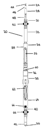
Referring to Figure 1 and Figure 2, in the preferred embodiment the
apparatus of the invention is comprised of a magnetic declination logging tool
(20) for
insertion in a borehole (22).
From an upper end (24) to a lower end (26) of the tool (20), in the
preferred embodiment the tool (20) includes a connector section (28), an upper
centralizer section (30), a casing collar locator ("CCL") section (32), a
reference probe
section (34), a crossover section (36), a magnetic probe section (38), a lower
centralizer
section (40) and a bull nose section (42). The various sections of the tool
(20) are in the
preferred embodiment connected to each other end to end with threaded
connections.
The sections may, however, be connected together in a different order, in a
different
manner, and two or more sections may also be combined into one section. The
guiding
limitation in the configuration of the tool (20) is that the tool (20) must be
capable of
passing through the borehole (22).
The connector section (28) enables the tool (20) to be connected to a
wireline (44), a pipe string (not shown) or some similar apparatus so that the
tool (20)
can be lowered into and retrieved from the borehole (22). The connector
section (28)
includes a cablehead (46) as a connector and a top plug (48). The wireline
(44) is
supported within and extends from the cablehead (46). Other types and
configurations
of connector may be used.
The upper centralizer section (30) assists in centralizing the tool (20) in
the
borehole (22). In the preferred embodiment the upper centralizer section (30)
includes a
plurality of upper bow springs (50) as centralizing devices which engage the
borehole
(22) as the tool (20) passes through the borehole (22). Any other type of
centralizing
device may be used in the upper centralizer section (30), or the upper
centralizer section
(30) may be eliminated altogether.
-18-
' CA 02291545 1999-12-03
In the preferred embodiment at least a portion of the borehole is lined
with a casing string (52) consisting of lengths of casing connected together
with casing
collars (54). The casing collar locator section (32) assists in establishing
accurate depth
control for the tool (20) by sensing the presence of the casing collars (54)
in the casing
string (52). The casing collar locator section (32) includes one or more
magnetic sensors
(not shown) which are capable of sensing a change in magnetic flux as the tool
(20)
passes a casing collar (54). The casing collar locator section (32) may
include a source of
magnetic field or it may rely on the earth's magnetic field. In the preferred
embodiment, the casing collar locator section (32) is equipped with a source
of magnetic
field (not shown) which generates a magnetic field which is sensed by the
magnetic
sensors (not shown). The casing collar locator section (32) is optional and in
fact will
not be necessary if the borehole (22) is uncased or if the casing string (52)
does not
include casing collars (54).
The reference probe section (34) is used to provide a reference directional
measurement which is not influenced by magnetic flux. As a result, the
reference probe
section (34) includes at least one reference instrument which may be comprised
of any
apparatus or device which can make such a reference directional measurement.
In the preferred embodiment the reference probe section (34) includes a
reference instrument which is comprised of a gyroscopic instrument (56)
contained
within a reference probe housing (58). Any type of gyroscopic instrument (56)
capable
of making the reference directional measurement may be utilized in the
reference probe
section (34).
For example, the gyroscopic instrument (56) may include a standard
gyroscopic instrument which requires orientation relative to a calibration
direction by
taking an external measurement or may include a north seeking gyroscopic
instrument
which uses true North as a calibration direction by utilizing the horizontal
component
-19-
CA 02291545 1999-12-03
of the earth's inertial angular velocity vector. In the preferred embodiment
the
reference probe section (34) includes as the reference instrument a north
seeking
gyroscopic instrument such as a G2TM gyroscope system manufactured by Sperry-
Sun
Drilling Services.
The G2TM gyroscope system includes a two-axis gyroscope and a triaxial
accelerometer. The horizontal component of the earth's inertial angular
velocity vector
is determined by correlation of the output of the gyroscope with the output of
the
accelerometer, thus enabling the system to be aligned to true North without
the need
for an external measurement. The second axis of the G2TM gyroscope system
allows
reliable directional measurements to be made by the system even where the
inclination
of the borehole (22) approaches or exceeds about 70° relative to
vertical and the first axis
is thus unable to provide reliable directional data.
One limitation of a north seeking gyroscopic instrument is that it becomes
less reliable as a gyrocompass at latitudes approaching or exceeding about
80°. As a
result, where the tool (20) is used at such latitudes a north seeking
gyroscopic
instrument will function as a conventional gyroscopic instrument, requiring an
external
measurement in order to obtain a calibration direction.
The function of the reference probe section (34) is to provide a reference
directional measurement which is not influenced by magnetic flux and to
provide a
mechanism to assist in establishing an orientation relationship between the
reference
probe section (34) and the magnetic probe section (38). As a result, the
reference probe
section (34) is equipped with an orientation calibration indicator for
providing a
calibration orientation for the reference instrument.
In the preferred embodiment the reference probe section (34) is equipped
with a reference orientation calibration indicator consisting of a gyroscopic
reference
-20
CA 02291545 1999-12-03
slot (60), which gyroscopic reference slot (60) provides a reference
instrument
calibration orientation. The purpose of the gyroscopic reference slot (60) is
to assist in
establishing the orientation relationship between the reference probe section
(34) and
the magnetic probe section (38).
The reference probe section (34) is configured so that the orientation
reference indicator will provide an indication of a known or ascertainable
calibration
direction as the reference instrument calibration orientation when the tool
(20) is
positioned in the borehole (22). The calibration direction may be any
direction.
For example, if the gyroscopic instrument (56) is a conventional
gyroscopic instrument the calibration direction may be a direction ascertained
by
external measurement made prior to or following use of the tool (20). If the
gyroscopic
instrument (56) is a north seeking gyroscopic instrument the calibration
direction may
be true North or some other direction as determined for example with reference
to the
earth's inertial angular velocity vector. In the preferred embodiment the
calibration
direction for the reference probe section (34) is true North, which means that
the
gyroscopic instrument (56) will indicate true North when the gyroscopic
reference slot
(60) is pointing at true North.
The crossover section (36) provides a means for linking the reference
probe section (34) and the magnetic probe section (38) such that a constant
alignment
and a convenient longitudinal spacing can be maintained between them. In the
preferred embodiment the crossover section (36) is threadably connected
between the
reference probe section (34) and the magnetic probe section (38) and maintains
alignment between them with the use of set screws or bolts and locking nuts.
Any apparatus which is capable of connecting the reference probe section
(34) and the magnetic probe section (38) while maintaining the alignment
between them
-21
' CA 02291545 1999-12-03
may be used as the crossover section (36). Furthermore, the crossover section
(36) may
be eliminated if the reference probe section (34) and the magnetic probe
section (38) are
integrally constructed as a single component of the tool (20). There may also
be
components of the tool (20) in addition to the crossover section (36) which
are
interspersed between the reference probe section (34) and the magnetic probe
section
(38).
The magnetic probe section (38) is used to provide a magnetic directional
measurement which is influenced by magnetic flux. As a result, the magnetic
probe
section (38) includes at least one magnetic instrument which is capable of
providing the
magnetic directional measurement.
In the preferred embodiment the magnetic probe section (38) is comprised
of a magnetic instrument (62) contained within a magnetic probe housing (64).
In the
preferred embodiment the magnetic probe housing (64) is constructed of a non-
magnetic material.
Any type of magnetic instrument (62) capable of making a magnetic
directional measurement may be utilized in the magnetic probe section (38).
For
example, the magnetic instrument (62) may be comprised of a magnetic compass
and
may be incorporated into a single shot or mufti-shot magnetic survey tool. In
the
preferred embodiment the magnetic instrument (62) is comprised of a magnetic
survey
system of the type which includes a magnetometer for making the magnetic
measurement, such as for example the Electronic Survey Service ("ESSTM")
system
manufactured by Sperry-Sun Drilling Services.
The ESSTM survey system includes a triaxial magnetometer and a triaxial
accelerometer. The horizontal component of the earth's magnetic field vector
is
determined by correlation of the output of the magnetometer with the output of
the
-22-
' CA 02291545 1999-12-03
accelerometer, thus enabling the system to be aligned to magnetic North
(subject to the
effects of sources of magnetic interference).
The function of the magnetic probe section (38) is to provide a magnetic
directional measurement which is influenced by magnetic flux and to provide a
mechanism to assist in establishing an orientation relationship between the
reference
probe section (34) and the magnetic probe section (38). As a result, the
magnetic probe
section (38) is equipped with an orientation calibration indicator for
providing a
calibration orientation for the magnetic measurement instrument.
In the preferred embodiment the magnetic probe section (38) is equipped
with a magnetic orientation calibration indicator consisting of a magnetic T-
slot (66),
which magnetic T-slot (66) provides a magnetic instrument calibration
orientation. The
purpose of the magnetic T-slot (66) is to assist in establishing the
orientation
relationship between the reference probe section (34) and the magnetic probe
section
(38).
The magnetic probe section (38) is configured so that the orientation
reference indicator will provide an indication of a known or ascertainable
calibration
direction as the magnetic instrument calibration orientation when the tool
(20) is
positioned in the borehole (22). The calibration direction may be any
direction. In the
preferred embodiment the calibration direction for the magnetic probe section
(34) is
magnetic North, which means that the magnetic instrument (62) will indicate
magnetic
North when the magnetic T-slot (66) is pointing at magnetic North (subject to
the effects
of magnetic interference).
The lower centralizer section (40) assists in centralizing the tool (20) in
the
borehole (22). In the preferred embodiment the lower centralizer section (40)
includes a
plurality of lower bow springs (68) as centralizing devices which engage the
borehole
-23-
CA 02291545 1999-12-03
(22) as the tool (20) passes through the borehole (22). Any other type of
centralizing
device may be used in the lower centralizer section (40), or the lower
centralizer section
(40) may be eliminated altogether.
The bull nose section (42) provides a leading surface at the lower end (26)
of the tool (20) for assisting the tool (20) in moving through the borehole
(22) and also
protects the other components of the tool (20) from obstructions and debris
which are
encountered in the borehole (22). In the preferred embodiment the bull nose
section
(42) is threadably connected to the magnetic probe section (38).
Alternatively, the bull
nose section (42) may be formed integrally with the magnetic probe section
(38) or may
be connected to the magnetic probe section (38) other than with a threaded
connection.
In preparing the tool (20) for use in a borehole (22) the various sections are
connected together and the gyroscopic reference slot (60) is aligned with the
magnetic
T-slot (66) to provide an indicator differential representing the amount by
which the
slots (60,66) are separated circumferentially from each other. The indicator
differential
may be any value but in the preferred embodiment the tool (20) is assembled so
that the
indicator differential is equal to zero, thus simplifying the calculation of
values of
magnetic declination.
The tool (20) may be equipped with a data transmission system for
transmitting data from the directional measurements from the tool (20) to the
ground
surface along the wireline (44) or in some other manner such as with a
measurement
while drilling ("MWD") system or with a telemetry system. Alternatively, the
tool (20)
may be equipped with a data storage device for storing such data until the
tool (20) is
retrieved from the borehole (22). In the preferred embodiment the tool (20) is
equipped
with a data transmission system which transmits data to the surface from the
casing
collar locator section (32), the reference probe section (34) and the magnetic
probe
section (38).
-24-
' CA 02291545 1999-12-03
The above description of the preferred embodiment of the tool (20) is
exemplary and as previously indicated, the order of the various sections
comprising the
tool (20) may be altered and some sections may be modified or eliminated
altogether.
Additional components may also be added to the tool (20). The only essential
components of the tool (20) are the reference measurement instrument and the
magnetic
measurement instrument, which may be provided in separate sections of the tool
(20) or
may be integrated into a single instrument section.
The method of the invention may be performed using the tool (20) of the
preferred embodiment of the apparatus form of the invention or may be
performed
using some other apparatus or collection of apparatus.
Generally, the performance of the method of the invention requires only
that a magnetic directional measurement be made at a longitudinal location in
the
borehole (22) and at a magnetic measurement orientation and that a non-
magnetic
reference directional measurement be made at a reference measurement
orientation
which has a known or ascertainable orientation relationship with the magnetic
measurement orientation. The absolute orientation at which either or both of
the
magnetic directional measurement or the reference directional measurement is
made
does not matter as long as the orientation relationship is ascertainable.
One advantage to the tool (20) of the preferred embodiment is that it is
capable of maintaining a constant indicator differential between the
gyroscopic
reference slot (60) and the magnetic T-slot (66). In the performance of the
method of the
invention, this feature results in a constant relationship between the
orientation at
which magnetic measurements are taken and the orientation at which reference
measurements are taken. In other words, the tool (20) establishes and
maintains the
orientation relationship.
-25-
CA 02291545 1999-12-03
In the performance of a preferred method form of the invention using the
tool (20), the sections of the tool (20) are first assembled so that the
gyroscopic reference
slot (60) is aligned with the magnetic T-slot (66), preferably so that the
indicator
differential is equal to zero.
Referring to Figure 2, the tool (20) is then lowered into the borehole (22) to
position the magnetic instrument (62) at a desired longitudinal location in
the borehole
(22). The desired longitudinal location may be achieved in any manner. For
example,
the desired longitudinal location may be established with reference to the
amount of
wireline (44) which has been paid out in lowering the tool (20) in the
borehole (22), by
moving the tool (20) through the borehole (22) relative to a benchmark station
of known
depth, by moving the tool (20) through the borehole (22) past a desired number
of
casing collars as indicated by the casing collar locator section (32), or by a
combination
of methods.
A magnetic directional measurement and a non-magnetic directional
measurement are then made with the magnetic instrument positioned at the
longitudinal location.
Finally, a value of magnetic declination at the longitudinal location is
obtained using the magnetic directional measurement, the non-magnetic
directional
measurement and the indicator differential.
The method may be repeated by moving the tool (20) through the
borehole (22) to a number of longitudinal locations and making magnetic and
non-
magnetic measurements at those longitudinal locations in order to obtain a
magnetic
declination profile for the borehole.
-26-
CA 02291545 1999-12-03
Two examples illustrating the use of the method and apparatus of the
invention follow.
Example 1
One exemplary application for the method is in establishing a magnetic
declination profile for a cased borehole (22) in which a whipstock (not shown)
or some
other form of diverting tool must be set for directional drilling or for
reentry into a
branch borehole (not shown).
In this application, the tool (20) may be run into the borehole (22) on the
wireline (44) after a bridge plug (not shown) has been set in the borehole
(22) at a kick-
off-point (not shown). The kick-off-point establishes the lower depth limit
for the
magnetic declination profile.
A magnetic declination profile is then created by making a series of
magnetic measurements and related reference measurements at a range of depths
above
the kick-off-point, following which the tool (20) is removed from the borehole
(22).
The whipstock is then lowered into the borehole (22) on a pipe string (not
shown) which includes a measurement-while-drilling ("MWD") system (not shown).
The MWD system includes a magnetic instrument (not shown) which is aligned in
a
known orientation with the whipstock face (not shown). The whipstock is then
oriented in the borehole (22) at the kick-off-point using magnetic directional
data which
is generated by the MWD system and is corrected using the magnetic declination
profile
for the borehole (22). The whipstock is set in the borehole (22) and if
necessary a
window (not shown) may be milled in the casing (52) at the kick-off-point
using a
milling tool (not shown).
- 27 -
CA 02291545 1999-12-03
Once the whipstock has been oriented and set in the borehole (22) and any
necessary window has been milled in the casing string (52) at the kick-off-
point, a
drilling string (not shown) including a downhole motor (not shown) and the MWD
system may be run into the borehole (22). The MWD system is connected with the
motor at a known orientation relative to a high side indicator (not shown) on
the motor.
The motor is positioned at the kick-off-point with its high side indicator
directed at the
window using magnetic directional data which is generated by the MWD system
and is
corrected using the magnetic declination profile for the borehole (22).
Drilling is then commenced, guided by magnetic directional data from the
MWD system which is corrected using the magnetic declination profile, until
sufficient
inclination angle is built or sufficient distance from the cased borehole (22)
is achieved
to enable drilling to be continued using a steering tool (not shown) or a
magnetic survey
tool (not shown).
Example 2
A second exemplary application for the method is in determining the
orientation of an orienting lug (not shown) in a packer (not shown) which has
previously been set in the borehole (22) at the kick-off-point while
simultaneously
generating data in order to create a magnetic declination profile for the
borehole (22)
above the kick-off-point.
In this application, the lower end (26) of the tool (20) is provided with a
mule shoe stinger (not shown) which is aligned with both the gyroscopic
reference slot
(60) and the magnetic T-slot (66). The mule shoe stinger is configured to
engage the
orienting lug on the packer when the tool (20) is run into the borehole (22).
The mule
shoe stinger is magnetically isolated from the magnetic probe section (38) of
the tool
-28-
CA 02291545 1999-12-03
(20) using a sufficient length of aluminum (not shown) or other non-magnetic
material
between the magnetic probe section (38) and the mule shoe stinger.
The tool (20) is run into the borehole (22) until the mule shoe stinger
engages the orienting lug. A magnetic directional measurement and a reference
directional measurement are made while the mule shoe stinger is engaged with
the
orienting lug. The magnetic declination survey may be conducted either as the
tool (20)
is run into the borehole (22) or as the tool (20) is retrieved from the
borehole (22).
The tool (20) is then removed from the borehole (22). A whipstock or
other diverting tool may then be lowered into the borehole (22) in a similar
manner as
in Example 1, with the mule shoe on the whipstock offset from the whipstock
face so as
to achieve a desired orientation relative to the orienting lug on the packer
when the
whipstock is set in the packer. If necessary, a window may be milled in the
casing
string (52) at the kick-off-point.
A drilling string may then be lowered into the borehole (22) in a similar
manner as in Example 1 and drilling may proceed as in Example 1.
As indicated, these examples are merely exemplary of the many potential
applications for the invention. In addition, variations of the two examples
described
above may be utilized.
For example, the steps of orienting the whipstock in the borehole (22) and
drilling from the kick-off-point may be performed using a conventional jointed
pipe
string or using a coiled tubing system (not shown).
In Example 1, the whipstock face may be suitably oriented at the kick-off-
point using a coiled tubing system in which a coiled tubing orienter (not
shown) is
-29
CA 02291545 1999-12-03
aligned in known orientation relative to both the magnetic instrument in the
MWD
system and the whipstock face. In Example 2, a coiled tubing system may be
used both
for lowering the whipstock into the borehole (22) and for drilling thereafter.
A coiled
tubing system may also be utilized instead of the wireline (44) or a pipe
string in order
to lower the tool (20) into the borehole (22).
-30-