Note: Descriptions are shown in the official language in which they were submitted.
CA 02292424 1999-12-22
WO 99/42853 PCT/IS99/00004
SYSTEM, APPARATCTS, AND METHOD FOR
GEOGRAPHIC POSITIONING OF MARINE FAUNA
HACRGROUND OF THE INVENTION
1. Field of the Invention
This invention relates to the field of stock
estimation of underwater resources by establishing the
geographic positions of representative animals, and in
particular to a method, system, and apparatus that utilizes
the Global Positioning System (GPS) or a similar
positioning system such as the Differential Global
Positioning System (DGPS), the Global Navigation Satellite
System (GNSS), the Russian Positioning Satellite System
(GLO-NASS), and Long Range Navigation (LORAN), for
establishing the position of animals underwater, and for
storing the established positions together with
identification indicia, and other information for later
retrieval, and/or for communication with a central station.
The invention takes the approach of adopting the
position of the reference vessel or buoy as the position of
the animal, rather than attempting to establish the exact
position of the animals in relation to a nearby reference
vessel or buoy as in U.S. Patent No. 5,331,602, thereby
reducing the complexity of equipment necessary to establish
position, while still providing advanced information
storage, retrieval, and communications capabilities.
1
CA 02292424 1999-12-22
WO 99/42853 PCT/IS99/00004
2. Descra.ption of Related Art
In order to better estimate the condition of
underwater resources, including sea, ocean, and freshwater
fauna, it is of vital importance to be able to register the
position of selected animals, and thereby track migration
and distribution patterns, particularly in relation to
environmental conditions. The environmental conditions
that influence an animal's migration patterns or behavior
are important parameters in modeling and/or simulation of
underwater resources, and study of the animal's reactions
to these parameters is critical if future resource
estimation is to be improved.
(i) Conventional Non-GPS Tracking Methods
The most common current method for-tracking underwater
fauna such as fish and other marine animals is simply to
tag them with labels and with an identification number.
The geographic position and the time of tagging are then
compared with the position and time of recapture of the
animal and recovery of the tag. This method has the
disadvantage that it requires capture of the animal each
time its position is to be determined, without providing
any information concerning what has happened to the animal
between tagging and recapture, or between successive
captures.
A second method currently used to track animals
underwater is to attach a sonic activator to the animal. A
ship with the necessary listening and receiving equipment
follows the animal in order to register its trail. This
method is expensive and it is only possible to follow one
or a very few animals at once for a short period. Once the
animal moves outside the range of the acoustic receiver, it
is lost.
2
CA 02292424 1999-12-22
WO 99/42853 PCT/IS99/00004
A third method is to tag animals with sonic activators
or hydro-acoustic sound sources hermetically sealed in a
tube that work at different frequencies, as disclosed in
Russian Patent Publication No. SU-131661a. The tube
simultaneously transmits underwater from the two sound
sources to establish the direction and position of the
animal relative to the measuring equipment, simplifying
tracking, but the use of acoustic positioning limits the
method to a limited geographic area, depending on the
amount of transmitter output power that can be generated by
equipment placed on or inside the animal.
in an article introduced at a conference in Copenhagen
on October 4-12, 1990, the Council Meeting of the
International for the Exploration of the Sea describes a
fourth tracking method that utilizes an acoustic sound
source tag which is placed on an animal, and three sonar
buoys placed on known coordinates around the area. Again,
the range of this method is limited by the use of acoustic
tracking and the requirement that the buoys be fixed.
A fifth method is to tag the animal with electronic
data storage tags of the type that the present applicant
for patent has developed and manufactures. The tags
measure environmental parameters such as temperature,
depth, and salinity, and from these environmental
parameters a position can be estimated. By comparing those
parameters to which the animal is exposed with known data
from the environment, a position can be estimated for a
relatively large geographic area. In addition, by adding
measurements of light to which the tag has been exposed, it
is possible to estimate the time for the sun's maximum
height, and thereby narrow the area in which the animal was
located. This method still has rather large uncertainties,
however, and can only be used with reasonable precision on
3
CA 02292424 1999-12-22
WO 99/42853 PCT/IS99/00004
an animal that stays close to the surface in areas where
there is a marked difference between day and night light
intensity. As a result, the method is not feasible in
Nordic regions where there is light for most.of the day in
summer, and darkness for most of the day in winter.
A sixth conventional geographic positioning method
involves so-called pop-up tags, which are tags that loosen
from the tagged animal and then float to the surface. When
the tag detects that it has reached the surface, it
transmits radio signals to, for example, a satellite,
airplane, ship, or land, which determines the position of
the tag. The tag can also transmit stored data to the
satellite or other receiver, and thus can be used to
provide a geographic position at the point where it
surfaces. However, there is a significant uncertainty as
to how long it takes the tag to make contact with the
tracking vehicle after the tag reaches the surface, and
tags of this type are large in size,. heavy, and are
therefore only suitable to be carried by large animals,
limiting the method to relatively large fish species. In
addition, the method can only be used to measure a single
position, which is the position of the tag after reaching
the surface, and thus cannot be used for detailed tracking.
(ii) Prior Use of GPS for Underwater Tracking
The present invention avoids the problems of the
above-described conventional methods by using a positioning
establishing system such as GPS in conjunction with sonar
or similar acoustic transponders to establish underwater
positions. The use of GPS transceivers and sonar
communications to establish underwater positions is also
known from U.S. Patent No. 5,331,602, but the present
invention differs from the method disclosed in U.S. Patent
No. 5,331,602 because it does not use sonar communications
4
CA 02292424 1999-12-22
WO 99/42853 PCT/IS99/00004
to establish position relative to the GPS transceivers, but
rather uses the sonar communications to either: (A)
establish the identity of a passing animal so that the
identity information can be associated with a position,
and/or (B) communicate position information to the passing
animal, without attempting to establish a precise relative
position between the animal and the GPS transceiver.
More significantly, U.S. Patent No. 5,331,602
discloses a method of establishing the position of
underwater objects or persons in which the GPS transceivers
are used to establish the positions of at least a pair of
buoys arranged to interrogate a transponder on the object
or person using sonar. The precise position of the object
or person relative to the pair of buoys can then be
established by analyzing propagation delays in the
communications between the two transceivers and between the
transponder and respective transceivers. -
While the system described in U.S. Patent No.
5,331,602 is useful for missions where cost is no object or
exact positioning is critical, such as military exercises,
it is less practical for tracking underwater animals whose
movements are less predictable, and which therefore require
relatively large numbers of positioning stations spread
over a large area. In the present invention, only a single
buoy or other vessel equipped with a GPS transceiver is
necessary to establish communication, and it is not
necessary to process the underwater transmissions for
positioning purposes, but only to receive previously
determined position or identification information.
The present invention shares the concept of
establishing the position of a buoy, and using sonar to
communicate with a transponder on the object being tracked,
5
*rB
CA 02292424 1999-12-22
WO 99/42853 PCT/IS99/00004
and in particular an animal, but does not use analysis of
propagation delays or any sort of triangulation method to
establish the exact position of the animal relative to the
buoy. Instead, it is sufficient to establish that a
particular animal is in the vicinity of the buoy, the
position of the buoy being adopted as the position of the
animal. The sonar or acoustic communications between the
buoy and the animal establish the presence of the animal
near the buoy rather than the position of the animal,
resulting in a tracking system that can utilize elements of
the system of U.S. Patent No. 5,331,602, but that is
significantly simpler and more practical to implement, at
least for the purpose of tracking underwater fauna.
Unlike the system of U.S. Patent No. 5,331,602, the
present invention also provides for storage of the position
of a particular animal as well as data concerning
environmental conditions, either in a memory situated in a
tag on the-animal itself, in a memory associated with the
buoy, or in a memory at a central location, so that
movements of the animal can be tracked and analyzed in
relation to the environmental conditions. Thus, despite
the simplicity of the positioning system of the invention,
it provides significant improvements relative to prior
underwater animal tracking methods, systems, and apparatus.
l3tJNNARY OF THE INVENTION
It is accordingly an objective of the invention to
provide a method, system, and apparatus for establishing
the position of underwater animals with sufficient
precision to enable tracking and behavior analysis while
still being relatively low in cost and practical to
implement.
6
CA 02292424 1999-12-22
WO 99/42853 PCT/IS99/00004
It is a further objective of the invention to provide
a positioning method, system, and apparatus for underwater
animals capable of establishing the position of animals at
multiple times and in widely spaced geographic areas.
It is a further objective of the invention to provide
a positioning system for underwater animals that uses
identification tags that can be fitted on a variety of
different types of underwater animals, including relatively
small species and young animals, and that not only
associates a particular identification tag with established
positions, but is capable of recording additional
parameters such as environmental conditions.
it is a further objective of the invention to provide
a positioning system for underwater animals that enables
the animals to be continuously tracked either from a
central station or locally for later retrieval and
analysis.
These objectives are achieved, in accordance with the
principles of the invention, by providing a system,
apparatus, and method for determining the positions of
underwater animals, in which equipment placed on the animal
communicates with a transponder associated with a position-
determining transceiver in order to establish proximity of
the animal to the transceiver, the position of the
transceiver being adopted as the position of the animal
either by communicating the position of the transceiver to
the equipment on the animal for storage therein, or by
communicating the identity of the animal for association
with a position and storage in the vessel or buoy that
carries the transceiver, and/or further transmission to a
base or central station.
7
CA 02292424 1999-12-22
WO 99/42853 PCT/IS99/00004
According to an especially preferred embodiment of the
invention, the equipment or tag placed on the animal
includes sensors for measuring environmental parameters for
association and storage together with location and time
data, so that behavior of the animal can be studied with
respect to the stored parameters, storage being carried out
either locally in the tag, in the vessel carrying the
position determining transceiver to which the data is
transmitted, or at a central station to which the data is
broadcast. The transponder associated with the tag is
preferably a hydroacoustic transducer such as a piezo-
electric element, which conveniently forms part of the
housing for the tag.
BRIEF DESCRIPTION OF THE DRAWINGS
Fig. 1 is a schematic view of the principal components
of a positioning system constructed in accordance with the
principles of a preferred embodiment of the invention.
Fig. 2 is a schematic view of a variation of the
positioning system of Fig. 1, in which the ship of Fig. 1
is replaced by a buoy.
Fig. 3 is a isometric representation of a tag for use
with the positioning system illustrated in Figs. 1 and 2.
Fig. 4 is a block diagram illustrating elements of the
positioning system illustrated in Figs. 1 and 2.
Fig. 5 is a schematic diagram of an arrangement for
-retrieving data from a tag of the type suitable for use in
the positioning system of the preferred embodiment of the
invention.
8
CA 02292424 1999-12-22
WO 99/42853 PCT/IS99/00004
Fig. 6 is a schematic diagram illustrating a situation
in which successive attempts at comunication from a moving
vessel may be used to more precisely establish the position
of an animal.
Fig. 7 is a flowchart illustrating a position
determining method according to a preferred embodiment of
the invention.
Fig. 8 is a flowchart illustrating an alternative
position determining method.according to another preferred
embodiment of the invention.
D]3TAILED DESCRIPTION OF THE PRRFERRED SD! ODIMENTS
The invention involves a system, apparatus, and method
for determining the positions of underwater animals, in
which equipment placed on the animal communicates with a
transponder associated with a position-determining
transceiver in order to establish proximity of the animal
to the transceiver, the position of the transceiver being
adopted as the position of the animal either by
communicating the position of the transceiver to the
equipment on the animal for storage therein, or by
communicating the identity of the animal for association
with a position and storage in the vessel or buoy that
carries the transceiver, and/or further transmission to a
base or central station. Initially, in section (1) a
preferred embodiment of the system and apparatus of the
preferred embodiment will be described in connection with
Figs. 1-6, after which in section (2) two methods of using
the preferred system and method are described in connection
with Figs. 7 and 8.
9
CA 02292424 1999-12-22
WO 99/42853 PCT/IS99/00004
1. System and Amaratus
Figs. 1 and 2 schematically illustrate the principal
components of a preferred system for determining positions
of underwater fauna in accordance with the principles of a
preferred embodiment of the invention, including a sonic
transceiver 2 or transponder A capable of receiving and
decoding positioning signals from a remote source 1, such
as a satellite, and of emitting and receiving sonar
communications 3 through the water. A transceiver or
transponder B attached to an animal 4 and capable of
communicating with transceiver A by sonar or other acoustic
transmissions.
The basic principle of the invention is to associate
particular tags with a geographic position, but instead of
determining the exact position of the tag relative to an
object whose position can be exactly determined, the
position of the object whose position can be exactly
determined is taken to be the position of the tag when the
tag is sufficiently close to the object to establish
acoustic underwater communications. In the case of the
preferred embodiment of Figs. 1 and 2, this is accomplished
as illustrated in Fig. 1 by positioning transceiver A
either on a ship 2, which may include fishing, research,
coastguard, freight, or navy vessels of all types, or as
illustrated in Fig. 2 by positioning the transceiver A on
a buoy 5 that has a fixed position or that is allowed to
drift. Alternatively, transceiver A may be positioned at
the bottom of a body of water, in a submarine, or even on
a portable land-based device set up on the shore of a lake
or river.
Associated with sonic transceiver A is a position-
determining device including a receiver capable of
receiving arbitrary signal frames from any of a variety of
CA 02292424 1999-12-22
WO 99/42853 PCT/IS99/00004
geographic positioning systems currently available,
including the Global Positioning System (GPS), the
Differential Global Positioning System (DGPS), the Global
Navigation Satellite System (GNSS), the Russian Positioning
Satellite System (GLO-NASS), or Long Range Navigation
(LORAN), as well as decoder circuitry capable of
determining a geographic position based on the received
arbitrary signal frames. The position-determining device
may either be a separate unit, integrated with transceiver
A, or part of a navigation system of the vessel on which
transceiver A is located.
Those skilled in the art will understand that in
addition to the above-mentioned currently available
navigation systems, the principles of the invention may
also be applicable to proposed navigation augmentation
systems such as the wide-area augmentation system (WAAS),
the multi-function transport satellite (MTSAT), and the
European Geostationary Navigation Overlay Service (EGNOS).
As will be discussed in more detail below, transceiver
A can be arranged to either transmit the position
information to transceiver B for storage in a memory
associated with transceiver B, interrogate transceiver B to
obtain the identification number and, optionally, other
information from transceiver B in order to associate the
position information with the identification number and a
time of contact for local storage or communication to a
base station.
In general, the system and apparatus illustrated in
Figs. 1 and 2 use established technologies to implement the
principles of the invention. GPS and other positioning
determining systems are well-known and commercially
available. Acoustic transponders that may mounted on the.
11
CA 02292424 2005-01-11
vessel and arranged to transmit position data are also
available, modulation of the acoustic signals with the
position data being a matter of routine software
programming using, for example, a standard computer
connected to the GPS transceiver and the acoustic
transponder, although it is also within the scope of the
invention to use modified or custom designed position
determining transceivers and transponders. An example of
an application combining a satellite-based positioning
determining system and a sonic transceiver is disclosed in
U.S. Patent No. 5,331,602.
As indicated above, suitable programmable tags are
available from Stjornu-Oddi (translated into English as
"Star-Oddi") of Reykjavik, Iceland, and hydroacoustic
transducers of appropriate frequency and size are available
from other sources for utilization in the Star-Oddi tag.
Modification of the currently available tags involves (i)
design or modification of the programmable controller chip
to receive, store, and transmit position and/or
identification data as described in more detail below, (ii)
addition of a hydroacoustic transducer for the purposes
described in more detail below and, as necessary,
miniaturization of the tag for use on a wider variety of
animals. All of these modifications are well within the
capabilities of the ordinary artisan based on the
descriptions presented below and the accompanying drawings.
By way of example, the Star-Oddi tag model DST300 can
be modified, as illustrated in Fig. 3, such that at least a
part of the housing 7 forms a piezo-electric ceramic
element that serves as the sonic transceiver, with part 8
of the housing containing a battery and the electronic
circuitry illustrated in more detail in Fig. 4, including
12
CA 02292424 1999-12-22
WO 99/42853 PCT/IS99/00004
sensors or transducers 16, analog and analog-to-digital
conversion circuitry 15, the piezo-electric element 10,
amplifier, mixer, and demodulator circuitry 11, a
microprocessor 12, and a memory 14 arranged to store
received and collected data and software for retrieving
data from the sensors and/or acoustic transmissions, and/or
for modulating stored data for transmission by the
hydroacoustic transducer, and sensors. The housing is
arranged to withstand high pressures and hermetically
sealed together with a ceramic pressure sensor 9 that
permits connection of external sensors to the sonic
transceiver equipment.
A sonic transceiver thus constructed, including
integrated sensors that measure both physical and
physiological parameters, has a diameter of 13 mm or less
and a length of 35 mm or less, forming a package that
weighs only a few gratns. In an even smaller version with
a more limited number of measured parameters, the sonic
transceiver equipment can be housed within a diameter of 9
mm or less, and a length of 25 mm or less, with a
substantial reduction in weight. This means that the
smaller and younger animals of a species that are currently
being researched can be tagged, as.well as species that are
too small for previously types of tags.
While the tag is receiving geographic position data
from. transceiver A, it can still be able to make other
measurements. In addition, the tag can make measurements
at times other than when it is in proximity to transceiver
A. Examples of other parameters that may be measured by
the additional sensors and that are useful for analyzing
animal behavior include environmental temperature, the
animal's temperature, depth, salinity, tilt angle in one,
two, or three directions, compass/direction, geomagnetic
13
CA 02292424 1999-12-22
WO 99/42853 PCT/IS99/00004
field strength, light intensity, registration of
environmental noise, heart rate, blood pressure, and
physical movements such as "tail beat", animal hormones and
pheromones, and the animal's own generated sounds and
breathing frequency. The invention thus makes it possible,
in a simple and economic fashion, to record both large and
small animals's migration routes underwater, and relate the
routes to other behaviors. Such information is extremely
important when determining fisheries' quotas and
controlling catches.
The piezo-electric elements 10 illustrated in Fig. 4
preferably can receive sonic signals within the frequency
range of 10 KHz to 200 KHz. Those skilled in the art will
appreciate, however, that any transducer that reacts to
pressure wave with a given change in electrical parameters
such as capacitance, resistance, frequency, crystal
resonance frequency, and so forth, may be substituted for
the illustrated piezo-electric elements, as may piezo-
electric elements and other types of transducers that have
an extended frequency range or a range that includes
frequencies that are lower or higher than 10 KHz to 200
KHz. The sonic transceiver equipment B receives signals
from the sonic transceiver A, demodulates the received
signal and reads it directly from the receiving frequency,
or from a lower frequency when the received signal has been
transferred to a lower frequency by mixer 11.
As illustrated, the tag is microprocessor controlled,
with appropriate software for the microprocessor 12 being
programmed into a memory, which may be in the form of a
memory built into the processor or may be included in
memory 14, which also serves to store positions and
measured data. To carry out the functions of the preferred
system, any low-energy microprocessor with appropriate
14
CA 02292424 1999-12-22
WO 99/42853 PCT/IS99/00004
integrated standard functions may be used. A number of
manufacturers currently offer microprocessors with the
requisite size and capabilities, including the ability
enter a sleep-mode during periods when no data is being
input from either the hydroacoustic transponder or the
sensors. Among the functions that can be routinely
programmed by the skilled artisan are the parameters that
should be sampled, the number of samples to be taken with
a given period, and the number of sampling periods.
When the tag is designed to store geographical
position data received from transceiver A, or even just
designed to broadcast identity and sensor data to
transceiver A for storage.on a ship or buoy, the received
positions and/or measured parameters are stored in the
memory 14, which may consist of a RAM or EEPROM, or any
other suitable storage medium. EEPROMs are preferred
because an EEPROM will hold data even after the battery or
power source for the tag is depleted. Whether or not an
EEPROM is used, however, the battery should be capable of
functioning for at least a year, since marine life cycles
or migration patterns normally cover the entire year.
Upon recovery of the tag or sonic transceiver B,
either by capture of the animal or separation of the tag
from the animal (separation may occur either as a result of
natural causes or at a preprogrammed time), the data is
transferred from the memory to, for example, a personal
computer 17 for further processing, as illustrated in Fig.
4. Data transfer may be achieved by a hard-wired or
wireless communications link 13, with power preferably
being supplied to the tag either through the hard-wired
connection or, in the case of a wireless connection, by
generation of power in the tag using application of high
frequency energy 20(1 MHz to 2 GHz) to activate the
CA 02292424 1999-12-22
WO 99/42853 PCT/1S99/00004
transmitter, thereby saving battery current to extend the
lifetime of the tag, and enabling communications with a tag
that has been in the field for an extended period and has
no battery life left. As illustrated in. Fig. 5, for
example, upon placement of the tag in a fixture which
exposes the tag to high frequency energy, and a resulting
generation of DC current 20 in the sonic transceiver to
power up the equipment for communication, modulator 18
modulates an internally generated high frequency signal
with data from microprocessor 12 and mixes it with the
exposed frequency from the fixture for transmission back to
the fixture via an antenna 21. As those skilled in the art
will appreciate, the generated high frequency signal could
have a range of anywhere from a few KHz to hundreds of KHz
or higher.
By way of example, a currently available sonar device
placed on a ship and a hydroacoustic receiver of the type
described above that has been placed 50 meters from the
bottom in the North Atlantic and operating at a frequency
of 24 KHz at a sound level of 205 dB/l Pa in spherical form
will have an echo level or signal strength of 85 dB at a
range of 10 Rm, depending on the absorption coefficient of
the water at the specified frequency, which depends on
environmental conditions such as temperature, salinity, ph
and pressure. The 85 dB level is just sufficient to
separate the acoustic transmission from the noise floor at
the 50 feet level. For animals that swim further from the
bottom, a lower signal level is possible to achieve the
same range, and the range can easily be lowered by simply
decreasing the sensitivity of the receiver or decreasing
the signal level of the output in order to achieve more
precise positioning of the animal when using sonar to
transmit acoustic signals that are modulated with position
16
CA 02292424 1999-12-22
WO 99/42853 PCT/IS99/00004
information into the water at a selected frequency during
normal operation.
2. Method
The method of the invention includes several
embodiments, all designed to determine whether an animal is
in proximity to a vessel such as a ship or buoy whose
position can be accurately determined, and to associate the
animal with the position, as follows:
(i) Sound Source Transmits Geocrrar)hical Position
In this embodiment, illustrated in Fig. 7, a satellite
receiving unit on board a vessel such as a ship or a buoy
obtains its geographic position (step 100) and broadcasts
the position using the sonic transceiver (step 110)
Preferably, the acoustic or sonic signals containing the
geographic position are transmitted in a sequence that has
a built-in delay between successive bits that allows
reflections from a previously transmitted bit to fade out
before interfering with later bits in the sequence.
If an animal carrying transceiver B is within range of
the acoustic signals from transceiver A, transceiver B
receives and decodes the signals (step 120) to determine
whether it contains messages and/or the geographical
position. The received geographical position is then
stored in the equipment's memory (step 130) and associated
with a time of receipt (either based on an internal clock
or included in the received transmission) and/or
environmental or physiological data from sensors in the tag
for later retrieval (step 140).
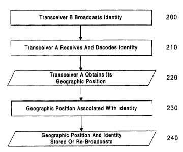
(ii) Transceiver A Receives Identification Information
In this embodiment, illustrated in Fig. 8, when an
animal with an appropriately arranged transceiver B comes
17
CA 02292424 1999-12-22
WO 99/42853 PCT/IS99/00004
within range of transceiver A, acoustic signals broadcast
by transceiver B, either periodically or in response to a
broadcast query from transceiver A, are received and
decoded by transceiver A in order to obtain an
identification number of the tag that includes transceiver
B (steps 200 and 210). Transceiver A then obtains its
geographic position using a GPS receiver or the like (step
220), associates the identification number and geographic
position together with related information such as the time
and date (step 230), transmits the identification number,
geographic position, and other information through a modem
to a central tracking station, and/or stores the
identification number, geographic position, and other
information in an appropriate storage medium such as a
tape, magnetic disk, or optical disc (step 240).
(iii) Two-Way Communication
In addition to the embodiments in which transceiver B
receives the geographic position from transceiver A for
local storage, and transceiver A receives the
identification information from transceiver B for local
storage or re-transmission, it is possible for transceiver
B to respond to receipt of geographic information by
transmitting the identification number of the tag, or for
transceiver A to respond to receipt of an identification
number by transmitting the geographic position, so that
storage of position can be carried out by both the tag and
the transceiver A.
(iv) Sleetp Mode and MultiAle Measurements
Preferably, for the embodiment in which the
transceiver B receives geographical data from transceiver
A, or in case the transceiver B is arranged to respond to
a broadcast query from transceiver A, when the
microprocessor has verified reception of a geographical
18
CA 02292424 1999-12-22
WO 99/42853 PCT/IS99/00004
position or query from transceiver A, it can be programmed
to put itself into a low current consumption state or
"sleep mode" for a pre-determined amount of time so as to
avoid storing repeated transmissions of the same
geographical data.
On the other hand, if transceiver A receives
transmissions from transceiver B, either in response to
receipt of geographic data or in order to establish
identity, and transceiver A is on a ship that is travelling
faster than the animal carrying transceiver B, the ship can
vary its path upon identification of a tag, as illustrated
in Fig. 6, in order to more precisely measure the animal's
position 23 by attempting to establish communications at
several points along a path to determine whether the animal
is still within the maximum range 22 of the ship's sonic
transceiver. This method can also be used if transceiver
B simply comes within range of a moving ship that is
broadcasting its position, the multiple positions being
stored in the tag so as'to enable the possible location of
transceiver B relative to the moving ship upon recovery of
the stored position data.
Alternatively, or in addition, when transceiver B
receives an acoustic signal from transceiver A, the
received signal strength can be used to give an indication
of the distance between transceiver A and B based on the
amplitude of the acoustic signal detected by the receiver
or analog-to-digital circuitry in transceiver B. This
indication can then be stored together with the position
information received from transceiver A. Still further,
transceiver A could transmit acoustically to the tag
together with the position information concerning the
strength of the signal output by transceiver A, i.e.,
information on the acoustic power output, which information
19
CA 02292424 1999-12-22
WO 99/42853 PCT/IS99/00004
could also be stored with the geographic position
information and the indication of signal strength to enable
the relative positions of transceiver A and B to be more
precisely determined upon recovery of the information.
(v) Programming and Placement of the Tact
Sonic transceiver B is customer specified in regard to
its programmed performance such as start time, sampling
time, number of samplings in a particular period, number of
sampling periods, listening times, waiting times, and so
forth. Researchers and scientists receive the sonic
transceiver equipment and program it to work in a specific
manner in relation to the research that is being performed.
For example, programming by the user may be carried out by
a wireless link, which may also be used to retrieve
information from the tag upon recapture of the tagged
animal.
The animal is tagged with the registration equipment
by fastening the equipment externally, by sewing, gluing,
or fastening with wire, or by surgical implantation in the
animal by, for example, making a small hole in the animal's
body cavity into which the sonic transceiver equipment is
pushed, or into flesh or muscle, and the hole is sewed
closed or glued back. No special treatment is necessary if
the hole is small enough.
Having thus described a preferred embodiment of the
invention with sufficient particularity to enable those
skilled in the art to easily make and use the invention,
and having described several possible variations and
modifications of the preferred embodiment, it should
nevertheless be appreciated that still further variations
and modifications of the invention are possible, and that
all such variations and modifications should be considered
CA 02292424 1999-12-22
WO 99/42853 PCT/IS99/00004
to be within the scope of the invention. For example,
although particularly useful for tracking underwater or
aquatic fauna using tags on the animals and ships or buoys,
the invention may possibly be used for tracking other
aquatic objects from platforms other than ships of buoys.
In addition, the position of the platform to obtains the
geographic position data may be determined by systems other
than the above described navigation or positioning systems.
Accordingly, the scope of the invention should not be
limited by the above description, but rather should be
interpreted solely in accordance with the appended claims.
21