Note: Descriptions are shown in the official language in which they were submitted.
. CA 02297177 2000-O1-21
Patent Attorney von Kirschbaum Attorney Cocker: DFO-9836 PCT
DESCRIPTION
AVIOVIC SYSTEM FOR AIRCRAFi,.EMPLOYING AN 0~-HOARD RADAR
DEVICE
FIELD OF SHE INVENTION
The invention relates to an avionic system for
aircraft, empioyi.g an on-board radar device Lhat displays a
two-dimensional, perspective image of the radar data
obtained for a sector region that lies ahead in the flight
direction, incl~~ding objects de~ected there, on a viewing
device.
DFSCRIPTION OF THE RELATED ART
U.S. Patent No. 3,988,731 discloses a radar device that
provides a two-dimensional, perspective representation of a
;0 sector regior. ly_ng ahead in the flight direction. In this
case, the respective sector is scanned by means of a
tightly-bundled fan beam that pivots in Lh~ horizontal
plane. ;he reflected radar signal is represented on the
viewing device, wish deflecting voy ages being generated in
'~S the hcrizontal and vertical directions, similarly to the
generation of television images.
So that remote landmarks and flying objects are not
superimposed too closely during a low-altitude flight, and
therefore cannot be resolved further, the position of the
20 aircraft carrying the radar is artificially raised to a
higher position through a change in the deflecting voltages,
CA 02297177 2000-O1-21
so the remote landmarks and flying objects located close
together lie further apart in elevation.
The pilot is therefore deceived by a higher flight
altitude. An analog vertical.and horizontal deflection
occurs on the monitor; a vantage point other than the actual
vantage point is simulated through a charge in the
de°leccion voltages_ Images are generated based on the real
antenna aperture of the mechanically-pivoted antenna with a
tight fan bund'~ing in the azimuth plane. mhe dis=ance radar
1~ resolution is determined by the radar pulse length.
German Patent documents DE 40 07 611 and DE 40 07 612
di3close a forward-looking radar in which two-dimensional
iTages are formed from land or water surfaces in a forward
sector from a flying platform, such as ar. airplane. To this
i5 end, in the known forward-looking radar, an antenna that is
rigidly mounted to the platzorm is cons~ructed from either a
plurality of irdividLal elements (DE 40 C7 611) disposed in
a straight row next to one another, or from a plurality of
individual elements (DE 40 07 612), preferably in the form
20 of horn antennas that are disposed in a straight line next
.o each other, and in two superposed rows. With a
predetermined aperture length 1 of each individual element,
and a predetermined spacing of n individual elements, the
antenna has an antenna length of L = n - I (DE 40 07 611) or
25 an antenna length of L = n ~ 1/2 (DE 40 07 612).
In the first nocument (DE 90 07 611), an individual
element transmits incoherently, and the other individual
elements subsequently receive simultaneously. In the second
- 2 -
CA 02297177 2000-O1-21
embodiment (DE 40 d7 612). the individual elements transmit
and subsequently receive consecutively, specifically from
the first to the last of the plurality of individual
elements.
:o effect a digital coupling of the inaividual
elements, each individual element is separately evaluated
dyg~tally, and, in both cases, a digital processing is
performed for each angular range through the correlation of
a special, predetermined reference function.
The following advantages ara attained with a forward-
looking radar of this type having a rigidly-mounted antenna
and a subsequent, specially-designed processing method:
a~ a high pivoting speed of the antenna lobe, because the
speed is attained electronically wi~h t:ne a;d of
special data processing, not mechanically;
b) a higher precision and, consequently, a better quality
of she images than with all devices available to this
point;
c) no dependence on the platform speed: arid
d) considerably lower maintenance costs.
A forward-looking radar system ef this type can also be
used ir. connection with helicopters, for example for search-
and-rescue or environmental missions, because no forward
speed is necessary for the use of this forward-looking radar
system, and the inherent movement of a stationary helicopter
located at n predetermined site is insignificant_
In conclusion, it is noted here that U.S. 5.053,70
discloses a method of imaging a topographical land model
- 3 -
CA 02297177 2000-O1-21
chat is represented in a three-dimensional space, the model
being created through the simultaneous combination of an
image generated in accordance wits the SAR (Synthetic
Aperture Radar) principle with ground-elevation information
in an aircraft. The ground-elevation information is
obtained either from the aircraf=, for example by means of
a radar height finder, or thro~~gh ground measurements. A
perspective representation of a terrain sector ahead of the
aircraft is not provided in the pilot's view.
SUMMARY OF THE 7NVFNTIQN
T_t is the object of the present invention zo provide an
avionic system that is suited for flat-wing as well as
rotary-wing aircraft, and is initiated by the pilot to fly
precisely to a desired target region, even under unfavorable
1.5 visibility conditions or with zero visibility, while meeting
extremely-high precision requirements, and to identify even
relatively-small obstacles, land safely and star up without
problems, with zero visibility.
According to the invention, which relates to an avionic
?0 system of the type mentioned at the outset, this object is
accomplished in that the radar device is a forward-looking
radar which, corresponding to its basic operating mode,
produces a high-resolution, map-consistent, overhead image
of received radar data, using the SAR (Synthetic Aperture
~5 Radar) principle, or a processing principle similar to SAR.
Also according to the invention, a digital image-
processing system is provided, in which the map-consistent,
- 4 -
CA 02297177 2000-O1-21
overhead view produced by the radar device is converted
purely geometrically into a corresponding image with a
centered-perspective projection in a quasi-pilot view. which
.s then displayed on the viewing device.
The radar resolution is no longer effected by the real
aperture of an antenna, but through the correlation of the
corresponding reference functions, as described in the
above-cited pate n documents CE 40 C7 611 azd DE 40 07 612.
Here, the overhead image is generated 'first.
1p The conversion =nto a perspective representation
corresponding to a pilot view involves a purely computerized
image processing, and can be performed exclusively
digitally. This changes the image correspondingly, so the
perspective is d~'ferent. Suitable image-processing
1~ algorithms can easily be created as software.
The image prodLCed on the viewina device with the
application of the _r.vention is h~~ghly qual-tative, because
the SAR method can produce an image with an extremely-high
resolution. For the pilot to attain a precise, and
2d therefore reliab~e, flight orientation under poor visibility
conditions, in accordance with the invention, it is
especially advantageous to replace a conventional radar
system operating with a real antenna aperture with the SAR
processing principle, which is otherwise on=y applied for
25 terrain observations in the aforementioned application.
Because of these features of the avionic system of the
invention, the use and application of the forward-looking
radar system has a wide application spectrum thet
- 5 -
CA 02297177 2000-O1-21
encompasses, for example, military reconnaissance and combat
helicopters, rescue and off-shore helicopters and transport
and civilian aircraft. The image quality attained with the
system of the invention cannot,be attained with any other
system at this time.
Tne avionic system of the invention thus provides an
all-weather sensor that can even be used under poor
visibility conditions, or zero-visibility conditions, as
well as at night. The centered-perspective projection in a
quasi-pilot view according to the invention creates a quasi-
opLical image with a continuous image representation, for
example or. a high-resolution color monitor, through a high
image-repetition rate.
The dependent claims describe advc.ntageous
modifications.
Eleva~cion information pertaining to the terrain of the
scanned sector region is advantageously incorporated, in a
partial 3-D representation, into the represented image. In
an especially advantageous embodiment, the elevation
information can be generated directly according to the
interferometric principle.
According to a further advantageous modification of the
invention, elevation information pertaining to the elevation
above ground of natural and/or man-made obstacles are
incorporated, in a paztial 3-D representation, into the
image with a centered-perspective projection with a quasi-
pilot view. Furthermore, color-coding can be implemented in
the two representation modes (overhead view and pilot view).
- 6 -
CA 02297177 2000-O1-21
In an advantageous modification of the avionic system
according to the invention, the system switches between a
first display mode, in which the sector is imaged in a map-
consistent, ovarhead view, and.a second display mode, in
which the sector is imaged in the centered-perspective
projection in a quasi-pilot mew en the viewing device.
In ari analogous manner, a radar device in the form of a
forward-looking radar can also be used in nautica'_
navigation in that the radar data obtained for a forward
..0 sector region in the direction of travel, including objects
detected there, are imaged in a two-dimensional, perspective
representation on a viewing device. Here, in an image-
processing device, a high-resolution, overhead image is
converted purely geometrically into a corresponding image
having a centered-perspective projection in a quasi-helmsman
view, and is displayed on the viewing device_ Elevation
information about the scanned, forward sector region can
also be incorporated, in a partial 3-D represen~ation, into
the image with a centered-perspective projection. in a quasi-
helmsman view; elevation information pertaining to the
elevation of natural and/or man-made obstacles can also be
incorporated in a 3-D representation.
Moreover, according to a further advantageous
embodiment of the invention, obstacles that may be present
z5 during landing approaches, and project beyond a
pradetermined elevation above ground, can be color-coded
botr in the map-consistent, overhead image and the quasi-
pilot view. Likewise, targets, particularly moving targets,
CA 02297177 2000-O1-21
selected during reconnaissance flights can be marked -
preferably with color - in both the overhead image and the
quasi-pilot view.
An especially practical and advantageous modification
of the avionic system according to tre invention lies in the
insertion of an artificial horizon in~o the image.
In accordance with an advantageous embodimen~ of the
invention, the cen~ered perspective representation in a
quasi-pilot view, with the inserted artificial horizon, is
also maintained in curved flight patterns. for exaT,p~e,
according to a modification of the invention, it is possible
to switch between map-consistent, overhead imaging and a
centered perspective representation in a quasi-pilot view,
with a respective inserted, artificial horizon, on a highly-
1.5 sensitive color monitor, even during curved flight patterns.
Likewise, it is possible to switch between different
range regions in both the map-consistent, overhead imaging
and the centered perspective representation in a quasi-pilot
view with the respective inserted, azti=icial :~.ori2on, which
:?0 assures an extended-sight mode.
In accordance with a further advantageous embodiment of
Che invention, it is also possible to switch the forward-
looking radar system between different frequency ranges, for
example from the L band (1.3 GHz) across the X band (9.6
.25 GHZ) and up to the Ka band, which is at about 35 GHz, as a
function of the respective field of application. :n the
switch to the Ka bend, the forwazd-looking radar system can
be used to recognize high-voltage lines, for example, or
- 8 -
CA 02297177 2000-O1-21
wire fences used for bordering areas.
In accordance with an advantageous embodiment of the
invention, she centered perspective representation in a
quasi-pilot view, with or with4ut an inserted artificial
S horizon. can be automatically adapted to the flight altitude
arid flight speed.
As further advantageous modifications of the invention,
additional data or information Can be inserted into the
centered perspective representation in a aaasi-pilot view,
:,0 such as distances to marked targets. the altitude of marked
targets or a marking of moving targets, resulting in an MTI
(Moving Target Indication) mode. Moving targets can also be
marked.
Within the =ramework of the invention, it is also
15 possible to combine the centered perspective representation
in a quasi-pilot view with further operating modes, such as
weather radar, surveillance radar or the 1'_ke.
Because of the high resolution capability attainable
with the use of the avionic system of the invention, a
20 device that warns of obstacles can be actuated or initiated,
for example, with the aid of received and purposeiu~ly
selected data. It is also possible to produce a so-called
head-up display representation.
In accordance with a further advantageous embodiment of
25 the invention, in addition to the image of the earth's
surface. information pertaining to the elevation above
around of natural and/or artificial obstacles can be
inclLded in the quasi-pilot view.
- 9 -
CA 02297177 2000-O1-21
The high-resolution graphic representation of the
flight sector lying ahead in the flight direction that can
be attained with the use of the forward-looking radar system
permits an application for flights within civil and military
scopes; thus, for example, autonomous landing approaches,
purposeful, precise load jettison'_na and the like can be
executed Yeliably.
BRIEF DESCRIPT:ON -OF THE DRAWINGS
The invention is described in derail below by way of
:LO various embodiments, with reference to the attached
draw_r.gs, which show in:
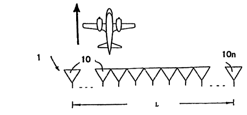
Ficr. _ a schematic representat~_on of an antenna
constructed from a plurality of adjacent
individual radiators, for use in forward-looking
i5 radar;
Fig. 2 a schematic representation of an illuminating
geometry, as results from an aircraft flying in a
predetermined flight direction:
Fig. 3 a plan view, in a map-consistent representation,
2C of a portion of a runway and its immediate
vicinity from a flight altitude of 1000 m:
Fig. 4 a centered-perspective representation in a quasi-
pilot view of the same portion of the runway and
its immediate vicinity, corresponding to the
25 representation of fig. 3;
Fig. S again, a plan view, in a map-consistent
representation; of n portion of a runway. but from
- l0 -
CA 02297177 2000-O1-21
a flight altitude of 300 m;
Fig. 6 a centered-perspective representation in a quasi-
pilot view, corresponding to the map-consistent
representation of Fig_. 3; and
Figs. 7 & 8 in :nap-consistent representations,
respectively a plan view of a tree formation
from a flight altitude o_' 100 m and special
markings for regions having a certain
elevation above gro::.~.d ( Fig . 8 ) .
;) ~MHODIMENTS O~' THE INVENTION
Eig. 1 scl~.ematically shows n individual radiators in
the form of horn antennas 10 disposed in a straight-line,
adjacent antenna arrangement 1. In an arrangement not shown
in detail, the antenna arrangement 1 is rigidly mounted to
:~ an aircraft - which is shown on a greatly-reduced scale -
specifically transversely to its flight direction, which is
indicated by an arrow, such that the primary radiation
direction of the horn antennas 10 is orien~ed in the flight
direction.
c0 According to DE 40 07 611, only one individual
radiator, i.e., one horn antenna 10, transmits; however, all
of the other individual elements, for example i:~ the form of
the horn antennas 10, then receive. .n contrast, in D~ 40
07 612, the n _ndividual radiators are used consecutively
a?5 from the first to the nth element to transmit, then to
receive.
The rev data can be processed in a manner similar to
- 11 -
CA 02297177 2000-O1-21
a.
the known SAR principle, with a synthetic aperture in DE 90
07 611 being replaced by half the spacing or, in DC 40 07
612, by the spacing between the first and the nth individual
radiators of the horn-antenna arrangement.
During the processing, the respect=ve signal is
correlated according to amplitude and phase, as a function
of the range, with a conjugated complex reference function,
not disclosed in detail here. A decisive factor. however,
is chat. at each individual element 10, the received signal
has a phase that differs from the tra:.smitted pulse due to
the di=ferent location between the transmitter and receiver.
This means thzt, in incoherent operation, the phase
relationship be~ween the individual elements must be
constant and known iDE 90 07 6i1>. Because coherent
~5 operation is employed in the transmitting and receiving
branches in DE 40 07 612, the relative phase position of the
signals received at different locatio-~s must be known in
this operating mode.
Tf the spacing between the n individual radiators 10 is
:20 ox, this spacing can be expressed by
px = 1 = h/O in DE 40 07 611; or
Ox = I/2 = x/20 in DE 40 07 612,
where I is the aperture length of each individual radiator,
is the wavelength and ~ is the illumination angle. The
25 illumination ang~e O is shown schematically in the
illumination geometry in Fig. 2.
If the distance between a target point T and an
individual radiator 10 of the respective antenna arrangement
- 12 -
CA 02297177 2000-O1-21
is represented by r, a. can be inferred from the schematic
representation of Fig. 2, the distance r can be expressed
by:
R~ + Ca-x)Z ,
with a representing zhe-distance between the central antenna
axis O and a point targat T, x representing the distance
between the central an~enna axis O and an individual
radiator 10 and R representing the range-gate spacing, which
can also be inferred in detail fzom the schematic
representation of Fig. 2.
.LO Fig. 3 shows a map-consistent, o~rerhead view produced
with a relatively-short antenna from a flight altitude of
1000 m in the X band. a portion of a runway can be
identified approximately in the center of the figure.
Fig. 9 Shows the corresponding, centered-perspective
.5 representation in a quasi-pilot view, which has been
obtained through a corresponding conversion of the map-
consistent representation in the overhead view of Fig. 3.
The upper region of Fig. 4 shows a portion of the runway,
while the lower region shows the area located in front of
20 the runway, seen in the flight direction. In Fig. 9. an
inserted artificial horizon, :or example in the form of a
black bar, is shown along the upper longitudinal edge of the
representation.
In Figs. 3 and 4, the illumination angle i5 60° in the
25 azimuth direction, and the depression angle ranges from 19°
to 60°. The resolution in the azimuth direction is 10 m in
- 13 -
CA 02297177 2000-O1-21
the close range and 35 m in the remote range, while the
resolution in the elevation direction is 3 m.
Fig. 5 shows a portion of the same runway in a map-
consistent, overhead view, in this case from a flight
altitude o~ 300 m_
Eig. 6 shows the centered-perspective representation in
a quasi-pilot view. An insertea arLi=yc~a,l. 11VL14V11, iwt
example in the form of a black bar, is shown along the upper
lo..~.gitudizal edge.
'LO Fig. 7 shows a map-consistent, overhead view of a tree
and bush formation at an X-band frequency of 9.6 GKz and
from a flight altitude of 100 m.
Fig. 8 shows the same cutout as in Fig. ~. In the
practical embodiment, colored markings indicate regions that
project at an elevation of, for example, more than 3 m above
the surrounding =egion, i.e., 3 m above the ground-
;n Figs. 7 and 8, as in Figs. 3 and 4, the illumination
angle is 60° in the azimuth direction, and zhe depression
angle ranges ~rom 14° to 60°. In Figs. 7 and 8, the surface
area resolution is 0.6 mZ in the near range, and 1.1 mZ in
the remote range.
- 14 -