Language selection

Search

Patent 2298534 Summary

Third-party information liability

Some of the information on this Web page has been provided by external sources. The Government of Canada is not responsible for the accuracy, reliability or currency of the information supplied by external sources. Users wishing to rely upon this information should consult directly with the source of the information. Content provided by external sources is not subject to official languages, privacy and accessibility requirements.

Claims and Abstract availability

Any discrepancies in the text and image of the Claims and Abstract are due to differing posting times. Text of the Claims and Abstract are posted:

  • At the time the application is open to public inspection;
  • At the time of issue of the patent (grant).
(12) Patent: (11) CA 2298534
(54) English Title: SYSTEM AND METHOD FOR CONTROLLING OF VEHICLES
(54) French Title: SYSTEME ET PROCEDE DE COMMANDE DE VEHICULES
Status: Expired
Bibliographic Data
(51) International Patent Classification (IPC):
  • G05D 1/02 (2006.01)
  • G08G 1/0968 (2006.01)
(72) Inventors :
  • SEGEREN, PATRICK HUBERTUS FRANCISCUS (Netherlands (Kingdom of the))
(73) Owners :
  • FROG TECHNOLOGY B.V. (Netherlands (Kingdom of the))
(71) Applicants :
  • FROG NAVIGATION SYSTEMS B.V. (Netherlands (Kingdom of the))
(74) Agent: FETHERSTONHAUGH & CO.
(74) Associate agent:
(45) Issued: 2005-05-03
(86) PCT Filing Date: 1998-08-04
(87) Open to Public Inspection: 1999-02-11
Examination requested: 2003-07-17
Availability of licence: N/A
(25) Language of filing: English

Patent Cooperation Treaty (PCT): Yes
(86) PCT Filing Number: PCT/NL1998/000450
(87) International Publication Number: WO1999/006898
(85) National Entry: 2000-02-02

(30) Application Priority Data:
Application No. Country/Territory Date
1006710 Netherlands (Kingdom of the) 1997-08-04

Abstracts

English Abstract


The invention
relates to a system for
simultaneously navigating
two or more vehicles over a
surface of relatively limited
dimensions at relatively
high speed and/or density of
these vehicles, comprising:
a central control unit (30)
at least provided with a
computer with memory and
a transmitter/receiver (31)
for communication with
each of the vehicles; marker
elements which are arranged
on or above the surface
and which mark a position
relative to the surface; and
two or more vehicles which
are each provided with
drive means for driving the
vehicle, steering means for
steering thereof, navigation
means for plotting a route,
a transmitter/receiver for
communication with the
central control unit and
sensor means for sensing the
position relative to the marker elements; wherein the vehicles move over the
surface in the same time period along possibly colliding
routes and wherein the position and speed of the vehicles are predetermined
precisely in time relative to the marker elements and is
maintained accurately relative to the marker elements during travel such that
the effort required in respect of traffic control and/or
communication with the central control unit and/or with another vehicle can be
reduced considerably.


French Abstract

Cette invention se rapporte à un système permettant de commander simultanément deux véhicules ou plus, sur une surface de dimensions relativement limitées, à une vitesse relativement élevée et/ou avec une densité relativement importante de véhicules. Ledit système comporte une unité de commande (30) centrale, dotée au minimum d'un ordinateur à mémoire et d'un émetteur/récepteur (31) permettant la communication entre les véhicules; des éléments marqueurs qui sont disposés sur la surface, ou au dessus de celle-ci, dans le but de marquer une position relative sur ladite surface et au moins deux véhicules qui sont pourvus d'organes d'entraînement permettant de les diriger, d'un organe de direction permettant de suivre un itinéraire, d'un émetteur/récepteur permettant la communication avec l'unité de commande centrale et d'un organe de détection conçu pour détecter la position relative des éléments marqueurs. Dans ce système, les véhicules se déplacent simultanément sur la surface, le long d'itinéraires sur lesquels peuvent se produire des collisions, la position des véhicules par rapport aux éléments marqueurs et leur vitesse étant préétablies précisément dans le temps et ladite position de ces véhicules par rapport aux éléments marqueurs étant maintenue avec précision au cours des déplacements de sorte que l'effort requis pour assurer la régulation du trafic et/ou la communication avec l'unité de commande centrale et/ou avec un autre véhicule, peut être considérablement réduite.

Claims

Note: Claims are shown in the official language in which they were submitted.


7


CLAIMS:

1. A system for navigating two or more vehicles over
a surface, said system comprising:
- a central control unit at least provided with a
computer with memory and a transmitter/receiver for
communication with each of the vehicles;
- passive marker elements which are arranged on or
above the surface and which mark positions (x, y) relative
to the surface; and
- two or more vehicles which are each provided
with drive means for driving the vehicle, steering means for
steering thereof, navigation means for navigating the
vehicle, a transmitter/receiver for communication with the
central control unit, and sensor means for sensing the
position relative to the marker elements;
characterized in that said two or more vehicles
simultaneously move over the surface of relative limited
dimensions with at least one of relatively high speed and
density of these vehicles, wherein the position and speed of
the vehicles is predetermined precisely in time relative to
the marker elements and is maintained accurately relative to
the marker elements during travel, and in that a route
planner uses time as an extra dimension for planning, said
route planner taking into account the occupied points
R1 (x, y, t) to Rn (x, y, t) of the routes R of 1 to n
vehicles, in addition to fixed obstacles O (x, y) when
calculating route n + 1 for vehicle n + 1.
2. System according to claim 1, wherein all routes
for all vehicles are precalculated by said route planner.


8


3. System according to claim 1, wherein the route
planner determines and implements new routes at a moment of
time, when a transport assignment is received from a vehicle
by the route planner.
4. System according to claim 1, 2 or 3 wherein the
marker elements are passive magnets, transponders or
optically detectable elements arranged in the surface at
regular distances.
5. System according to claim 4, wherein the
transponders have a diameter of 10 mm or less.
6. A system according to any one of claims 1-5,
wherein the sensor means or the vehicle are movable such
that a number of numbered marker elements can be scanned by
the sensor means, whereby position and orientation of the
vehicle are determined.
7. A system according to claim 6, wherein the sensor
means comprise a rotatable antenna, wherein the position of
the antenna is derived from two or more angles between three
or more detected transponders and the orientation of the
vehicle is derived from the angle between the longitudinal
axis of the vehicle and one of the transponders.
8. A system according to claim 7, wherein the antenna
comprises a substantially elongate loop.
9. A method of navigating two or more vehicles,
comprising the steps of:
- arranging passive marker element on or above a
surface;


9


- providing a central control unit which at least
includes a computer with a memory and a transmitter/receiver
for communication with each of the vehicles; and
- providing two or more vehicles which are each
provided with drive means for driving the vehicle, steering
means for steering thereof, navigation means for navigating
the vehicle, a transmitter/receiver for communication with
the central control unit, and sensor means for sensing the
position relative to the marker elements;
characterized in that said two or more vehicles
simultaneously move over the surface of relative limited
dimensions with at least one of relatively high speed and
density of these vehicles, wherein the position and speed of
the vehicles is predetermined precisely in time relative to
the marker elements and is maintained accurately relative to
the marker elements during travel, and in that a route
planner uses time as an extra dimension for planning, said
route planner taking into account the occupied points
R1 (x, y, t) to Rn (x, y, t) of the routes R of 1 to n
vehicles, in addition to fixed obstacles O (x, y) when
calculating route n + 1 for vehicle n + 1.
10. A method as claimed in claim 9, wherein at
locations defined by the marker elements it is determined
whether the time of passage along that intersection
corresponds with the anticipated time of passage.
11. Method as claimed in claim 10, wherein the drive
means of the vehicle are actuated if deviations occur between
the desired time of passage and the actual time of passage.

Description

Note: Descriptions are shown in the official language in which they were submitted.


CA 02298534 2000-02-02
WO 99/06898 PCT/NL98/00450
1
SYSTEM AND METHOD FOR CONTROLING OF VEHICLES
Applicant markets many control system
applications for automatically controlled vehicles which
vary from unmanned transport of containers in a dockyard
to the transport of components in a factory building and
5 driverless transport of passengers, for instance between
a parking place and the passenger terminal of an airport.
The known system of applicant, which is
described inter alia in the American patent specification
4.847.773, makes it possible to navigate a vehicle in
accurate manner. Major modifications to the system are
prevented even after particular obstacles on the surface
have been moved. Using computer means a new path for the
vehicle can be simply computed each time on board the
vehicle or from a central point.
At higher speed or a greater number of vehicles
within a determined area problems occur with respect to
the response speed of this existing system, particularly
when frequent communication with a central control unit
must take place. The area can be divided into sectors in
order to enable control of the traffic. If two vehicles
require to travel through the same sector, the first
vehicle has for instance to have been driven wholly
through this sector before the second vehicle can enter
it. Communication with a central control unit must take
place each time in time-consuming manner in order to
obtain permission to enter a section. Also in the case of
transport by passenger vehicles, for instance at high
speed in a limited space, wherein the route to be trav-
elled by the vehicle is determined centrally from the
central control unit to the vehicles, it is important to
increase the accuracy of the position of each vehicle at
any desired point in time.


CA 02298534 2004-03-12
21766-902
2
It has further been found impractical for a new
vehicle, or a vehicle left stranded in the area due to
breakdown, to have to be initialized manually.
Embodiments of the present invention provide a
system for simultaneously navigating two or more vehicles
over a surface of relatively limited dimensions with at
least one of relatively high speed and density of these
vehicles, comprising:
- a central control unit at least provided with a
computer with memory and a transmitter/receiver for
communication with each of the vehicles;
- marker elements which are arranged on or above
the surface and which mark a position relative to the
surface; and
- two or more vehicles which are each provided
with drive means for driving the vehicle, steering means for
steering thereof, navigation means for plotting a route, a
transmitter/receiver for communication with the central
control unit and sensor means for sensing the position
relative to the marker elements;
wherein the vehicles move over the surface in the
same time period along possibly colliding routes and wherein
the position and speed of the vehicles is predetermined
precisely in time relative to the marker elements and is
maintained accurately relative to the marker elements during
travel such that the effort required in respect of traffic
control and/or communication with the central control unit
and/or with another vehicle can be reduced considerably.
The route planner of the central control unit uses
time as an extra dimension: a route n consists of a set of


CA 02298534 2004-03-12
21766-902
3
occupied points Rn (x, y, t). When calculating route n + 1
the planner must therefore also take into account the
occupied points Rl (x, y, t) to Rn (x, y, t) in addition to
the fixed obstacles O (x, y).
Another embodiment of the invention provides a
method of navigating two or more vehicles, comprising the
steps of: arranging passive marker element on or above a
surface; providing a central control unit which at least
includes a computer with a memory and a transmitter/receiver
for communication with each of the vehicles; and providing
two or more vehicles which are each provided with drive
means for driving the vehicle, steering means for steering
thereof, navigation means for navigating the vehicle, a
transmitter/receiver for communication with the central
control unit, and sensor means for sensing the position
relative to the marker elements; characterized in that said
two or more vehicles simultaneously move over the surface of
relative limited dimensions with at least one of relatively
high speed and density of these vehicles, wherein the
position and speed of the vehicles is predetermined
precisely in time relative to the marker elements and is
maintained accurately relative to the marker elements during
travel, and in that a route planner uses time as an extra
dimension for planning, said route planner taking into
account the occupied points Rl (x, y, t) to Rn (x, y, t) of
the routes R of 1 to n vehicles, in addition to fixed
obstacles 0 (x, y) when calculating route n + 1 for vehicle
n + 1.
Subject to the application, different methods are
possible. One possible method is based on pre-calculating
all routes for all vehicles by the central coordinating
computer. The vehicles will then travel in accordance with
the pre-determined ~~scenario". Two very different examples


CA 02298534 2004-03-12
21766-902
4
of this method are: 1) cars with passengers which move
criss-cross relative to each other in a surprising manner
(amusement industry) and 2) unmanned vehicles which travel
according to a pre-determined 'timetable'.
Another method is applicable when the transport
assignment is not known beforehand. In this case, as soon
as a transport assignment is received, the central computer
will determine a route which takes into account all routes
which are still being implemented at that moment. An
example hereof is automatic landing and removal of
containers during loading and offloading of container ships.
Unmanned container carriers herein travel over the quay
between ship and storage area via routes which can mutually
intersect at many points.
In a system according to an embodiment of the
present invention congestion and delay are avoided as far as
possible in that via interaction of the vehicle with the
marker elements it is determined in each case whether the
vehicle passes a determined position on the surface at the
correct point in time. Should deviations threaten to occur,
the drive means are actuated in order to cause the vehicle
to travel faster/slower depending on the deviation.
The marker elements can be laser beacons or, in a
quite different application, satellites for instance for
GPS, but in the preferred embodiment of the present
invention are magnets, transponders or colour transitions or
material transitions which are linear and which are arranged
at regular intervals in the surface. The advantages hereof
are relative simplicity of arranging such elements and the
inexpensive sensor means required on board the vehicle.


CA 02298534 2004-03-12
21766-902
4a
In a further preferred embodiment of the
invention, use is made of transponders which are arranged in
the surface, optionally in addition to other marker
elements, in order to make it easier for vehicles to be
taken up into the system again after standstill or
breakdown. For this purpose the vehicle is, or the sensor
means are, embodied such that within the surface covered by
the vehicle when it is stationary the sensor means can scan
a number of transponders. The transponders each have a
different response characteristic, or a different number, so
that the vehicle can determine its position and orientation
on the basis of a number of received responses.
Further advantages, features and details of
embodiments of the present invention will be elucidated on
the basis of the following description with reference to the
annexed drawings, which show schematically a system and
method according to embodiments of the present invention and
in which:
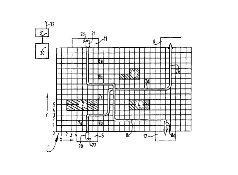
fig. 1 shows a schematic top view of a travel plan
for two vehicles with colliding routes, wherein a preferred
embodiment of the system according to the present invention
is used; and
fig. 2 shows a view in perspective of a preferred
embodiment of a vehicle according to the present invention.
A first vehicle 20 provided with an antenna 22
must be navigated in a coordinate system X1, XZ . . , Y1, YZ . .
from a starting station 5 to an end station 6 via line
sections 7a, 7b, 7c, 7d and 7e. Situated in the area are
obstacles 2, 3 and 4, the positions of which are known in a
central control unit 30 which is provided with a
transmitter/receiver 31 with antenna 32. The route of the
vehicle 20 is calculated or planned either in the vehicle or


CA 02298534 2004-03-12
21766-902
4b
in central control unit 30. In the present case this
resulted in the route according to the above designated line
sections.
In area 1 a vehicle 21 must also be navigated from
a station 11 to a station 12. Calculations performed either
in vehicle 21 (provided with antenna 23 for communication
with control unit 30) or in the computer of control unit 30
provide for instance a route according to line section 8a,
8b, 8c and 8d, which intersects route 7.


CA 02298534 2000-02-02
WO 99/06898 PCT/NL98/00450
Area 1 is provided with linear transitions or
magnets or transponders on the intersections of the
coordinate system X, Y. By determining at each passage
along a transponder or magnet whether the time of passage
5 corresponds to the time of passage anticipated according
to the planning, correct planning can prevent vehicles 20
and 21 simultaneously passing over route section 7c in
different directions. Traffic regulation and communica-
tion hereby become less necessary, which can increase the
speed of control and/or vehicles.
The route planning for vehicles 20 and 21 is
performed by central control unit 31, which must comprise
a powerful computer in the case of a large number of
vehicles.
In the system according to the present
invention passive transponders are preferably arranged in
the surface in addition to passive magnets which are
recommended when vehicles travel at high speeds of for
instance more than 5 m/s. The transponders each have a
different response characteristic and are as it were
numbered. Zn the preferred embodiment the transporters
are situated close together such that when the sensor
means under the vehicle move or when a substantially
round vehicle rotates on its axis, a number of responders
are scanned by the sensor means, whereafter the vehicle
can transmit its position via the antenna to the central
control system, which can then in turn determine via
which route the vehicle can continue on its way.
A vehicle 20 (figure 2) is preferably provided
on its underside with a rotatable antenna designated
schematically with 25 which, when turned, covers at least
three transponders 26 provided with a code or number,
whereby the vehicle can determine its position on ini-
tialization by reading the three unique codes in combina-
tion with the angles at which the different transponders
are detected. The codes correspond to known positions in
the ground plan of the working area which is stored in
the memory of the vehicle control. The exact position of


CA 02298534 2000-02-02
W4 99/06898 PCT/NL98/00450
6
the centre of the antenna can be derived from the two (or
more) mutual angles between the three (or more) detected
transponders. The angle between the vehicle axis and one
of the transponders then provides the orientation of the
vehicle.
The antenna used is preferably embodied as a
single elongate loop, but other embodiments can also be
envisaged provided that detection of more than one
transponder at a time is prevented.
The advantage of such an antenna is that it is
not necessary to measure a position directly, this
requiring a much more complex antenna and electronics.
Because the angle associated with the moment of detection
of a transponder is used to determine location, compact
standard code-transponders and associated detection
systems obtainable as standard can be used. The
transponders can have a diameter of l0 mm or less and can
consequently be arranged simply and advantageously in the
f loor .
The present invention is not limited to the
_ above described preferred embodiment thereof, nor to the
above described applications. Applications such as cars
'with people on board which move criss-cross relative to
each other in the amusement sector are a future prospect.
The rights sought are defined by the following claims,
within the scope of which many modifications can be
envisaged.

Representative Drawing
A single figure which represents the drawing illustrating the invention.
Administrative Status

For a clearer understanding of the status of the application/patent presented on this page, the site Disclaimer , as well as the definitions for Patent , Administrative Status , Maintenance Fee  and Payment History  should be consulted.

Administrative Status

Title Date
Forecasted Issue Date 2005-05-03
(86) PCT Filing Date 1998-08-04
(87) PCT Publication Date 1999-02-11
(85) National Entry 2000-02-02
Examination Requested 2003-07-17
(45) Issued 2005-05-03
Expired 2018-08-06

Abandonment History

Abandonment Date Reason Reinstatement Date
2001-08-06 FAILURE TO PAY APPLICATION MAINTENANCE FEE 2002-02-04
2004-08-04 FAILURE TO PAY APPLICATION MAINTENANCE FEE 2005-01-27

Payment History

Fee Type Anniversary Year Due Date Amount Paid Paid Date
Application Fee $300.00 2000-02-02
Registration of a document - section 124 $100.00 2000-03-23
Maintenance Fee - Application - New Act 2 2000-08-04 $100.00 2000-08-04
Reinstatement: Failure to Pay Application Maintenance Fees $200.00 2002-02-04
Maintenance Fee - Application - New Act 3 2001-08-06 $100.00 2002-02-04
Maintenance Fee - Application - New Act 4 2002-08-05 $100.00 2002-07-31
Request for Examination $400.00 2003-07-17
Maintenance Fee - Application - New Act 5 2003-08-04 $150.00 2003-07-31
Final Fee $300.00 2004-11-08
Reinstatement: Failure to Pay Application Maintenance Fees $200.00 2005-01-27
Maintenance Fee - Application - New Act 6 2004-08-04 $200.00 2005-01-27
Maintenance Fee - Patent - New Act 7 2005-08-04 $400.00 2005-11-25
Maintenance Fee - Patent - New Act 8 2006-08-04 $400.00 2006-12-28
Maintenance Fee - Patent - New Act 9 2007-08-06 $400.00 2007-09-26
Maintenance Fee - Patent - New Act 10 2008-08-04 $250.00 2008-07-28
Maintenance Fee - Patent - New Act 11 2009-08-04 $250.00 2009-07-28
Registration of a document - section 124 $100.00 2010-03-25
Maintenance Fee - Patent - New Act 12 2010-08-04 $250.00 2010-07-29
Maintenance Fee - Patent - New Act 13 2011-08-04 $250.00 2011-07-26
Maintenance Fee - Patent - New Act 14 2012-08-06 $250.00 2012-08-02
Maintenance Fee - Patent - New Act 15 2013-08-05 $650.00 2013-10-28
Maintenance Fee - Patent - New Act 16 2014-08-04 $450.00 2014-07-25
Maintenance Fee - Patent - New Act 17 2015-08-04 $450.00 2015-07-28
Maintenance Fee - Patent - New Act 18 2016-08-04 $450.00 2016-08-01
Maintenance Fee - Patent - New Act 19 2017-08-04 $450.00 2017-07-31
Owners on Record

Note: Records showing the ownership history in alphabetical order.

Current Owners on Record
FROG TECHNOLOGY B.V.
Past Owners on Record
FROG NAVIGATION SYSTEMS B.V.
SEGEREN, PATRICK HUBERTUS FRANCISCUS
Past Owners that do not appear in the "Owners on Record" listing will appear in other documentation within the application.
Documents

To view selected files, please enter reCAPTCHA code :


To view images, click a link in the Document Description column. To download the documents, select one or more checkboxes in the first column and then click the "Download Selected in PDF format (Zip Archive)" or the "Download Selected as Single PDF" button.

List of published and non-published patent-specific documents on the CPD .

If you have any difficulty accessing content, you can call the Client Service Centre at 1-866-997-1936 or send them an e-mail at CIPO Client Service Centre.


Document
Description 
Date
(yyyy-mm-dd) 
Number of pages   Size of Image (KB) 
Representative Drawing 2000-03-28 1 14
Abstract 2000-02-02 1 74
Description 2000-02-02 6 301
Claims 2000-02-02 2 87
Drawings 2000-02-02 1 38
Cover Page 2000-03-28 2 85
Description 2004-03-12 8 327
Claims 2004-03-12 3 112
Cover Page 2005-04-11 1 54
Fees 2000-08-04 1 41
Fees 2006-12-28 2 61
Correspondence 2000-03-15 1 2
Assignment 2000-02-02 3 88
PCT 2000-02-02 15 523
Assignment 2000-03-23 2 103
Assignment 2000-05-09 1 48
Prosecution-Amendment 2003-07-17 1 36
Prosecution-Amendment 2003-09-16 2 34
Prosecution-Amendment 2004-03-12 10 357
Correspondence 2004-11-08 1 30
Fees 2005-01-27 2 67
Fees 2007-09-26 1 36
Assignment 2010-03-25 4 133
Fees 2012-08-02 1 65
Fees 2013-10-28 3 112
Fees 2014-07-25 2 82
Maintenance Fee Payment 2015-07-28 2 84