Note: Descriptions are shown in the official language in which they were submitted.
~
CA 02299136 2000-02-22
1
METHOD FOR THE LOCALIZING OF TERRESTRIAL MOBILE RADIOS FROM AN
AIRCRAFT
BACKGROUND OF THE INVENTION
1. Field of the Invention
The present invention relates to a method and a device for the localization,
from an aircraft, of fixed or mobile terrestrial transmitters. These
transmitters belong to
a system of TDMA type cellular radiocommunications. In particular, this system
consists of a radiocommunications network using the GSM or DCS 1800 system.
The
DCS 1800 standard is a development of the GSM standard. The acronym TDMA is an
to abbreviation of the term « Time Division Multiple Access ». It is sometimes
replaced
by the acronym AMRT which is an abbreviation of the French term « Acces
Multiple
Repartition dans le Temps ». The acronym GSM is an abbreviation of the term
« Global System for Mobile communication ». The acronym DCS is an abbreviation
of the term « Digital Cellular System ».
The GSM network makes it possible to set up digital communications,
between mobile units or between mobile units and subscribers to the public
switched
network.
To enable the network to offer these services, a series of functions has
been defined. These functions are those required of any network of mobile
units.
2o Such functions include, for example, dialling, routing towards a mobile
user, cell
transfers, etc. These functions are distributed among entities.
2. Description of the Prior Art
The full network, shown schematically in Figure 1, includes several of
these entities. An entity may be:
* a mobile station or mobile stations.
The mobile station is the physical equipment used by the user of the GSM
network to access the telecommunications services on offer. There are various
types
of mobile stations: these include mobile stations mounted on vehicles and
portable
units. Portable units currently account for the major part of the market for
mobile
3o stations. Mobile stations (MS) can move through a certain number of cells.
* a radio sub-system or BSS (Base Station System).
The Base Station System is the equipment that covers a given
geographical area known as a cell. The BSS contains the hardware and software
needed to communicate with the mobile stations. Functionally, this Base
Station
System is divided between a control function carried out by a Base Controller
Station
~
CA 02299136 2000-02-22
2
or BSC and a radio transmission function carried out by the Base Transceiver
Stations
or BTS.
Each cell is covered by means of a base transceiver station that manages
the connection with the mobile station using an interface called a "radio
interface".
The relations between the base transceiver stations BTS and the base
station controllers BSC are defined by " the Abis interface ". The base
station
controllers BSC are connected to the rest of the GSM network by means of the
"A
interface".
* a " Network and Switching Sub-System " (NSS).
1o The NSS consists of three elements:
- the MSC ("Mobile services Switching Center"): this is the switching
center of the mobile service in charge of the routing of the communications to
and from
the mobiles in a cell,
- the HLR ("Home Location Register"): this is the data base in which the
permanent parameters of a subscriber are recorded; the HLR furthermore
contains
constantly updated information on the localization of the mobile unit,
- the VLR ("Visitor Location Register"): this is the data base in which there
is recorded the precise localization of the mobile unit in the calling zone.
Figure 2 illustrates a typical configuration of use of mobile stations MS,
2o base transceiver stations BTS and a base station controller BSC. Several
mobile
stations MS are managed by one base transceiver station BTS. Several base
transceiver stations BTS are connected to a single base station controller
BSC.
The structure of the network is of the cell type, i.e. the capacity of the
network is obtained by making a grid of the territory by means of cells that
are each
served by a base transceiver station. A major characteristic of a cell network
is the
re-utilization of the frequencies through the network A concept associated
with this
characteristic is that of the pattern of re-utilization. The pattern of re-
utilization defines
the number of juxtaposed cells that do not use the same frequencies.
Figure 3 shows an exemplary mode of planning for the use of frequencies
3o with a Size 4 pattern of re-utilization. In this example, two cells using
the same
frequency, for example the frequency having the number 3, are at a distance of
at
least one cell from each other.
The size of the cells may vary from a hundred meters to several tens of
kilometers. An aircraft that flies over the cellular radiocommunications
network is likely
to intercept the signals sent out in several cells and even the signals sent
out by cells
CA 02299136 2000-02-22
3
using the same frequency. Thus, the problem arises of knowing how to localize
the
different transmitters from the aircraft.
SUMMARY OF THE INVENTION
To this end, an aim of the invention is a method for the real-time
s localization of terrestrial transmitters belonging to a TDMA type cellular
radiocommunications network. The method consists of:
the interception, from an aircraft, of radioelectric signals and the
detection of these signals by the implementation of a multichannel
synchronization
fo determine the various sources of transmission,
- the simultaneous computation of an elevation angle 0 and an azimuth
angle 8 to instantaneously determine the direction of arrival of the
radioelectric signals
from the determined transmission sources,
- the building of tracks in the geographical areas in which the transmission
sources are located in order to estimate the position of the transmitters.
The method consists of the use of an antenna array distributed over an
aircraft and of the association of techniques of multi-sensor synchronization
with a
technique of high-resolution direction finding in order to carry out the real-
time
geographical localization of terrestrial transmitters of a TDMA type cellular
radiocommunications system.
2o From the signals received on a network of distributed antennas, the
invention synchronizes the received transmissions. The received transmissions
can
arrive simultaneously, whereas they will have been sent out by different
mobile
stations. The method of synchronization is associated with a recognition
function to
enable the detection of the transmissions coming from one and the same source
in
2s spite of possible overlapping between the various transmissions coming from
different
sources. After the recognition of the transmission sources, the method
according to
the invention carries out an operation of high-resolution direction finding.
The high
resolution direction finding provides information on the elevation and azimuth
angles of
the direction of arrival of the signals sent by the different sources, in the
reference
3o frame of the aircraft.
The aircraft moves with reference to the absolute geocentric reference to
which terrestrial transmitters are related. It moves at a certain attitude.
The attitude is
characterized by instantaneous angles of roll, pitch and yaw. The method uses
information from the inertial guidance unit of the aircraft in order to
convert the
3s direction of arrival of the signals sent by the transmission sources from a
reference
system of the aircraft into the absolute geocentric reference, and to compute
the
' CA 02299136 2000-02-22
4
intersection of their direction with the earth by using a digital ground
model; the points
of intersection are called elementary plots. In the geographical areas in
which sources
are present, the method builds tracks. The positions of the transmitters are
extracted
from the tracks, for example by locating the maximum density of the track, or
for
example by computing a weighted barycenter of the elementary plots of each
track.
Since the GSM transmitters can function in frequency-hopping mode, it is
necessary to be able to carry out localization operations with a small number
of
measurements. The use of techniques based on a density of probability enables
the
extraction of reliable localizations. This is done by taking account of errors
on only
to some elementary plots.
BRIEF DESCRIPTION OF THE DRAWINGS
Other characteristics and advantages of the invention will appear from the
following description. The description is made with reference to the appended
figures
of which, schematically:
- Figure 1 shows a GSM type radiocommunications network according to
the prior art,
- Figure 2 shows a typical configuration of the use of mobile stations MS,
base transceiver stations BTS and a base station controller BSC according to
the prior
art,
- Figure 3 shows an example of a prior art mode of planning for the use of
frequencies with a Size 4 pattern of re-utilization,
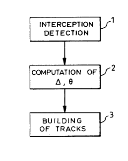
- Figure 4 shows the method according to the invention in the form of a
flow chart,
- Figure 5 shows a view of a device that implements the method
according to the invention, the device being split up, in the figure, into its
various
functions,
- Figure 6 shows a curve corresponding to the criterion PMUS1C(B> ~> for
two sources with incidence of 60 degrees and 100 degrees in azimuth ( B) and 0
degrees in elevation ( o= 0 ),
- Figure 7 is a azimuth-elevation goniometric representation,
- Figure 8 is a first view of a spectrum of the MUSIC criterion,
- Figure 9 is a second view of a spectrum of the MUSIC criterion,
- Figure 10 shows an exemplary grid around a plot,
- Figure 11 a shows a window known as a 4-connexities window,
- Figure 11 b shows a window known as an 8-convexities window
- Figure 12 provides an illustration of the construction of watersheds.
CA 02299136 2000-02-22
MORE DETAILED DESCRIPTION
In the various figures, homologous elements are given the same
reference numbers.
The method according to the invention is presented in the form of a flow
5 chart in figure 4. In a first step, the method consists of the interception
1, from an
aircraft, of radioelectric signals and of their detection 1 by means of a
method of
multichannel synchronization to determine the various transmission sources. In
a
second step, from the synchronized signals, the method carries out a
simultaneous
computation 2 of an elevation angle o and an azimuth angle B to
instantaneously
1o determine the direction of arrival of the radioelectric signals from the
determined
transmission sources. The method carries out the computation 2, in the
absolute
geocentric reference system, of the intersection of the directions of arrival
of the
radioelectric signals from the various transmission sources with the ground,
using a
digital ground model, to determine the geographical position of the
transmission
sources in the absolute geocentric reference system. In a third step, the
method
builds tracks 3 in the geographical areas in which the transmission sources
are located
to estimate the position of the transmitters in these geographical areas.
A device that implements the method according to the invention is shown
in figure 5. It comprises an antenna array 4, a multichannel receiver 5, a
time
2o management system 6, a system 7 for the localization and detection of the
trim of the
aircraft, a digital processor 8.
The antenna array 4 consists of antennas 9 distributed over the aircraft.
This antenna array 4 can be called a "patch" antenna array. The antenna array
4
intercepts the radioelectric signals coming from radio transmitters at input
and gives
the received signals at output.
The multichannel receiver 5 consists of a calibration pack 10 and a
synchronous multichannel receiver 11. The calibration pack 10 enables the
periodic
calibration of the radio reception channels in order to correct the relative
drifts between
the channels. The calibration is a known function that consists of the
sending, before
3o the acquisition of signals, of a known reference signal. The comparison of
the outputs
of the reception channels makes it possible to determine the relative values
of
compensation to be introduced into the reception channels in order to obtain
an
identical response at the output of each channel.
The time management system 6 provides a time reference.
CA 02299136 2000-02-22
6
The aircraft trim localization and detection system 7 provides the position
and trim of the aircraft with respect to the absolute geocentric reference
system to
which the transmitters are related.
The digital processor 8 comprises a control and processing device 12, a
storage unit 13 and a user interface 14. The storage unit 13 is used to store
data.
The user interface 14 displays data to a user and acquires data entered by a
user.
The digital processor 8 performs the following functions:
- the digitization of the signals given by the synchronous multichannel
receiver,
1o - the storage of the signals on the storage unit 13, with a common time
reference,
- the determining of the list of the TSC (Training Sequence Codes)
reference sequences detected on the channel as well as the associated levels
of
reception and the positions of synchronization,
- the use of these synchronization positions in order to determine the
angles of arrival,
- correlation between the position and trim of the carrier and the directions
of arrival in order to provide, by ground intersection, elementary
localizations known
as plots,
- the grid-mapping of a geographical area and the computation of density
to build an image on the basis of the plots,
- the grouping of the plots by adaptive tracking that gradually refines the
tracks,
- the localization of the transmitters by the extraction of maximum values
or the computation of a weighted barycenter of the plots assembled in tracks,
- the providing of a display to a user and the acquisition of data entered
by the user, through an interface with the user 14.
The outputs of the antenna array 4 are connected to the inputs of the
calibration pack 10. The outputs of the calibration pack 10 are connected to
the inputs
3o of the synchronous multichannel receiver 11. The time management system 6
has an
output connected to the synchronous multichannel receiver 11 and the
processing and
control device 12, to give them a common time reference. The aircraft
localization and
trim detection system 7 is connected to the processing and control device 12
to give it
the position and the trim of the aircraft. The processing and control device
12 is
connected, by a two-way link, firstly to the storage unit 13 and, secondly, to
the user
interface 14. The processing and control device 12 has two outputs. One output
is
CA 02299136 2000-02-22
7
connected to the synchronous multichannel receiver 11 and the other output is
connected to the calibration pack 10.
The first step of the processing consists in detecting the presence of
bursts on a traffic channel or TCH. The French equivalents « salve » or «
paquet »
are very infrequently used. Hereinafter in the description, only the term «
burst » will
be used. All the bursts of a traffic channel TCH are bursts having the same
physical
structure, namely a reference sequence of 26 symbols sandwiched by two data
fields
of 58 useful symbols. .
The GSM standard envisages the use of eight different TSC reference
1o sequences that allow a certain degree of separation between communications
using
the same frequency.
The method comprises a multichannel synchronization, each possible
sequence being successively tested and the position of the detected bursts and
the
detected sequences being given at output.
This detection is carried out in an environment where the power of the
signal to be detected may be lower than the power of another transmission
present on
the same channel. To overcome this difficulty, the method implements a
technique of
multichannel synchronization known and described in the patent [ 1 ] and the
patent
application [ 2 ]. This technique enables a modem to be synchronized by means
of the
2o learning sequences inserted into the waveform in the presence of
scramblers. The
principle of this technique is described below.
Let d(n), n=0...,L be the complex modulated GMSK signal corresponding
to the learning sequence of a synchronization channel (SCH) or traffic channel
(TCH)
sampled at the frequency Fe. The frequency Fe is not obligatorily a multiple
of the
symbol frequency.
Let X(n), n=0,...,N be the multi-sensor signals received, sampled at the
frequency Fe. N is such that the period of acquisition is greater two seconds;
this
duration makes it possible to be sure that the acquired message is a type 3
message
and that it gives information on the identity of the cell. The presence of a
burst
3o belonging to a synchronization channel (SCH) or a traffic channel (TCH), is
detected
on the sample p if the multichannel synchronization criterion C(p) is above a
threshold
S. The threshold S depends on the desired probability of false alarm:
C~P) = rXd ~P)+.R~~P)~rXd ~P) ( )
N 1
N ~ ~ Idcn)I2
n=0
CA 02299136 2000-02-22
g
with:
N
rXd(P)= N~ ~X(n+P)~d*(n)
n=0
N
R~y~y(P) = N ~ ~ X(n+P)~~'(n+P)+
n=0
The implementation of multichannel synchronization thus requires, for
each position p tested, the computation of YXd ( p) , 1t ~ ( p) , the reverse
of R ~ (p) ,
and the criterion i-Xd (p)+.R~ ( p).rXd (P)
In order to limit the computing power of the multichannel synchronization,
1o the matrix R~(p) is computed and reversed every P positions, i.e. for the
positions
p0 such that p, modulo P, is zero. The matrix is calculated by making the
correlation
on N+P samples:
N+P
R~(PO)= N+P~ ~ X(n+p0)~X(n+p0)+
n=0
On the P positions following the position p0, the criterion C(p) is computed
by using R~(pp) , the computation of rXd(p) remaining unchanged.
During a second step, the method carries out a high-resolution direction
finding in preferably implementing the known direction-finding algorithm
MUSIC. A
description of the algorithm MUSIC can be found in the article by R.SCHMIDT,
"A
2o Signal Subspace Approach to Multiple Emitters Location and Spectral
Estimation",
Ph.D. Thesis, Stanford University, CA, November 1981. This algorithm offers
the
possibility of carrying out direction-finding operations on several sources.
There are
various situations for which the transmission is a multi-source type
transmission:
- the aircraft intercepts signals transmitted in several cells,
- or else the aircraft intercepts a signal that has followed multiple paths
and the propagation is known as a multi-path propagation.
The second situation is less probable than the first one, but it can occur in
an urban or mountainous context. It is all the more probable that the signals
transmitted in several cells will be received simultaneously as the aircraft
is at a high
3o altitude. The MUSIC Algorithm is based on the assumption that the signals
received
on the sensors are written as follows:
CA 02299136 2000-02-22
9
M
x(t)_ ~a(Bm,Om)Sm(t)+b(t)=As(t)+b(t) (5)
m=1
where A is the matrix of the direction vectors such that:
A=~a(Bl~~l)>...,a(B,~,OM)~
The MUSIC method is based on the structure of the matrix of covariance
RXx and it entails the assumption that the noise b(t) is spatially white. This
means that
the noise level is the same on all the sensors, and that it is decorrelated
between two
distinct sensors. The matrix of covariance of the signal x(t) is written as
follows:
R~ = ELr(t)x(t)+~ = A RSS A+ +b2 I~ (6)
where RSS is the matrix of covariance of the source signal s(t), b2 is the
to background noise and Id is the identity matrix. Thus, the breakdown into
characteristic
elements of the matrix R,~,~ gives the following result
RXX =ECx(t)x(t)+,=ES LS ES +b2EbEb (7)
Given that the value of the matrix of covariance of the noise is bzld" by
combining the relationships (6) and (7), we get
ARSS A+=ES(LS -62)E~ (8)
for Id = EE+ with E = ~ES Eb
Let M be the number of sources. The matrix of the signal space Ls is
diagonal and has a size of MxM. The direction vectors of the matrix A are
linear
2o combinations of the eigen-vectors of the signal space Es, according to the
relationship
(8). The breakdown into characteristic elements of R,~ shows that the eigen-
vectors
of the matrices Es and Eb are orthogonal. Consequently, the direction vectors
of the
matrix A are orthogonal to those of the noise space Eb. Thus, for all the
incident
sources with an incidence (Bm, om) , it is possible to write the following
relationship:
a(qm,Dm)+Eb=0 forl__<m5M (9)
The search for the values of incidence (Bm, om) consists in minimizing the
following criterion along B and o .
a (B~ 0)+ EbE+
PMUSIC(B~0)= a(B'Q)+a(B'Q)
CA 02299136 2000-02-22
When the conditions are ideal, the function p,~,IUSlC(B> o) gets cancelled
for all the angles of incidence (Bm, om) of the incident sources. The
expression of this
function makes it possible to assert that it is standardized between 0 and 1.
Figure 6 represents the curve corresponding to the criterion p,~USIC(B~ ~)
5 for two sources having incidence values of 60 degrees and 100 degrees in
azimuth
and 0 degree in elevation ( o= o ) . As planned, the criterion is cancelled
for B= 60
and B=10o degrees. However, when the matrix of covariance is computed on a
finite
time of integration, and when the direction vector a(8,,~) is not fully known,
the
minimum values of the criterion do not reach exactly 0. Under these
conditions, the
to direction-finding operation consists in taking the M minimum values of this
criterion.
The direction-finding operation is considered to be valid, when the minimum
values of
the criterion are below a threshold. For example this threshold is fixed at
0.1.
The azimuth-elevation goniometric representation illustrated in figure 7 is
done in the space (u, v) with a = cos(o) cos(B~ and v = cos(o) sine(B) as the
co-ordinates
of the wave vector. Indeed, the precision of estimation of the parameters
(ttyy~,vm) is
independent of their position. Figures 8 and 9 show the spectrum of the
criterion of
MUSIC in the presence of two sources with values of incidence: Bl = o~ and
0 0
Ol = 60 giving, ul = 0,5 and vl = 0 , and B2 = 60
The trace of the spectrum of the function -lOloglO~pMUSIC(u~v), , of which
2o figures 8 and 9 give two different representations, makes it possible to
carry out the
direction-finding by seeking the peaks of the trace of this function.
The elevation angle Dm and azimuth angle 6m determined by the method
of high-resolution direction finding are corrected by taking account of the
trim and
orientation of the aircraft. The trim and orientation of the aircraft are
provided by the
inertial guidance unit of the aircraft. The correction is carried out by
taking regular
measurements of the attitude of the aircraft. The attitude of the aircraft is
expressed in
terms of the instantaneous angles of roll, pitch and yaw.
The corrected values of the elevation and azimuth angles are converted
into geographical positions called elementary plots. The corrected angles of
elevation
~m and azimuth Am are given in the reference system of the antennas in
relation to the
aircraft. The conversion consists in converting them into elevation and
azimuth angles
in relation to the absolute geocentric reference. The geographical positions
are
obtained by taking the intersection of the direction of arrival, associated
with an
elevation angle and an azimuth angle expressed in the absolute geocentric
reference,
with a digital model of the ground. The points of intersection are called
elementary
plots.
CA 02299136 2000-02-22
11
The third step consists in locating the transmitters from the elementary
plots by techniques of tracking.
One characteristic of the GSM transmitters is that each alternation of
communication uses a set of levels whose frequency is random. The usual
techniques
of radio-geographical tracking cannot adapt to this lack if constancy of
frequency.
Only techniques of adaptive tracking can be used. The measurements used in
searching for GSM transmitters are the elementary measurements that are output
from the measuring equipment, i.e. the elementary plots.
The GSM transmissions have noteworthy techniques that are exploited to
1o gather the elementary measurements before the fine localization. The
adaptive
tracking uses image-processing techniques to assemble the elementary
measurements by geographical segmentation.
The image-processing techniques consist of a grid-making operation, a
computation of density of geographical probability, filtering operations and
segmentation operations by a construction of watersheds.
The grid-making operation makes the geographical grid of the
geographical areas in which the elementary plots are located.
The computation of density of probability consists of the determining of the
conditional law of the vector to be estimated, the measurements vector being
known.
2o Two types of computation methods can be used:
* a method with a histogram of measurements,
* a method with an assumption of a normal law: the matrix of covariance
of the measurements vector is known, and by assumption, the measurements
vector
follows a centered normal law.
There is a third method but it is more expensive in terms of computation
time: this is the method of the fine computation of density by means of the
Monte-Carlo test.
In a first mode of performing the method, the procedure used to compute
the density consists in computing a histogram of measurements. The histogram
of
3o measurements is computed on a state space. If, for example, the
measurements are
the intersections with the earth, and if the state space is the localization
on the surface
of the earth then, with each new measurement, then the box of the grid
corresponding
to the state space in which the measurement is located is incremented by a
unit. For
example, a mesh in which there are three measurements has a density of three.
In a second mode of performing the method, the procedure used to
compute the density consists in assuming that the measurements vector follows
a
CA 02299136 2000-02-22
12
centered normal law. This computation of density is particularly suited to the
low
volumes of measurements generated by transmitters with little activity. The
matrix of
covariance of the measurements vector is known. It is assumed that the
measurements vector follows a centered normal law. Each box of the grid of the
state
space is incremented by the value of the conditional density. If, for example,
the
measurements are the intersections with the earth, and if the state space is
the
localization on the surface of the earth then, at each new measurement, each
box I of
the grid of the state space is incremented of a value p; . Taking the
following notation:
for a measurement (xm, ym), for the co-ordinates of the box i (x;, y;), and
for the matrix
to of covariance of the measurement:
2
~x °~xY et ~ -1 = ~~11 ~12~ (1 1 )
\a~xY ~y X21 ~2 J2
then the value p; is expressed by the relationship:
pi = A.exp -~ (xi -xm Yi -Ym)L. 1 xt - xm (12)
Yi Ym
with: A = 1
1 (13)
2~r(det~ ) 2
that is
pi = A.exp~-2~(B+C~~ (14)
with
B=(xi -xm)2w11+(Yi -Ym)2w22 (15)
Problems of quantification may arise because of an excessively coarse
grid, or there may be problems of an excessively large number of computations
because of an excessively fine grid. To circumvent these problems, the
distance
between two successive meshes is preferably fixed at N times (1<_ N <_3) one
"mean"
standard deviation, Sigma, of measurements made on all the elementary plots.
Figure 10 illustrates the grid around an elementary plot.
For a given plot, not all the grid is not crossed because many values of
probability are almost zero. The only portion crossed is an area around the
plot whose
edges correspond to K x sigma. Preferably K = 3.
~. __
CA 02299136 2000-02-22
13
The geographical density computed here above can have undesirable
discontinuities for the adaptive track processing operations. For this reason,
a set of
filtering modules is used. The filtering carried out by a module is either
linear or
morphological.
The goal of these filtering processing operations is to remove unnecessary
information from a density image or to emphasize certain regions by the use of
linear
and/or morphological filters. The choice of the filtering to be carried out is
made
according to the dispersion of the measurements on the geographical area to be
exploited.
1o For linear filters, a window defining the local work zone is used. This
local
zone is centered on each mesh of the geographical area to be processed. The
local
zone defines the geographical neighbors to be considered for this mesh. Figure
11 a
illustrates a window known as a 4-connexities window; the local zone, centered
on a
mesh referenced 0, comprises four neighbors referenced 1, 2, 3 and 4. Figure
11 b
illustrates a window called an 8-connexities window; the local zone, centered
on a
mesh referenced 0, comprises eight neighbors referenced 1, 2..., 8.
Whatever the linear filter, i.e. whatever the window, the principle of its
implementation is the same. The only change is in the combination made by
means of
the values of the neighbors. The principle consists in replacing the value of
the central
mesh, referenced 0, by a linear combination of the neighboring meshes and in
repeating the operation for each of the meshes of the geographical region.
Different types of linear filter can be implemented. These are, in particular:
- A type of filter called a mean filter: the combination made consists of
the computation of the mean of the neighbors of the central mesh,
- A type of filter called a median filter: the combination consists in sorting
the values of the neighboring meshes in ascending order and in assigning the
central
mesh the value of the median mesh of the sorted list; that is to say the value
five for a
list of indices going from zero to eight,
- A type of filter called a weighting filter: the combination made consists in
3o applying a multiplier coefficient to each neighboring value according to
its distance
from the central mesh; this makes it possible to restore a decreasing
influence of the
neighbors by using decreasing weighting coefficients,
A type of filter called a quantifier filter: this filter does not use the
concept
of vicinity. It enables the conversion of an image of density while imposing a
finite
number of authorized values for the meshes, as desired by the user.
CA 02299136 2000-02-22
14
A type of filter called a threshold-setting filter: this filter uses a visual
representation of the distribution of the values of the meshes between the
minimal
value and the maximum value, by sections of 10%. A threshold is chosen; below
this
threshold the meshes take the value of zero; above this value, the meshes
remain
unchanged.
The morphological filters resulting from the mathematical morphology
make use of a structuring element similar to the window of the linear filters.
The
difference, compared with the linear filters, lies in the fact that image to
be analyzed is
compared with a known form which is the structuring element. This element is
to be
1o adapted according to the forms that it is desired to process. Various types
of
morphological filter can be implemented. These filters are, in particular:
- A type of filter called an erosion filter: the principle used is to keep all
the
x's of space such that in x the entire structuring element is contained in the
form of the
figure. In the case of an image with gray levels or a color image, the
algorithm uses
an 8-connexities window for each mesh and assigns the minimum value of the
vicinity
to the central mesh,
- A type of filter called a expansion filter: the operation of expansion is
complementary to that of erosion. For each mesh, the maximum value of the
vicinity
is retained,
- A type of filter called an opening filter: the opening is defined from the
basic operators which are the erosion and expansion operators. First the
erosion of
the original density is computed and then the expansion of the result obtained
is
computed. The result is a density without the narrow uneven features and
narrow
projecting features of the image,
A type of filter called a closing filter: the closing consists of an expansion
of the original density to which an erosion is applied. The consequence of
this is the
elimination of the small enclaves given at input.
The opening and closing filters have a remarkable advantage; only one
application of the filters is necessary because the filters are idempotent.
This means
3o that, unlike in the case of erosion and expansion, a repetition of these
filtering
operations is unnecessary because the result obtained after repetition is
identical to
the result obtained after the first application.
The filtering processing operations have another characteristic: they can
be performed quickly. They require only one exploration of the image. They can
be
used at any time during the exploitation to improve a computed density.
CA 02299136 2000-02-22
IS
From the previously filtered density image, the segmentation operation
builds watersheds in the image so as to demarcate zones of influence. Each
zone
constitutes a track so that, at the end of this operation, J tracks
corresponding to J
regions are available.
A digital image h can be modelled as a set of meshes, or blocks likened to
elementary points of a real image; the blocks may be considered to be
equivalent to
pixels. The concept of catchment area C(M) associated with a minimum M is
defined
by all the pixels or meshes p of In such that a drop of water falling into p
runs along the
relief of h along a downward path that leads it to the minimum M.
1o The lines, between the various catchment areas C(M), constitute a
watershed noted LPE.
Figure 12 illustrates the construction of the watersheds. From a
topographical point of view, the image I~ is regarded as a surface for which
each of the
minimum values has a hole made in it. This surface is slowly immersed in a
sheet of
water presumed to be infinite for the convenience of the explanation. Water
gradually
fills the catchment areas of I~ in passing through these perforated minimum
values,
and especially through the minimum values at the lowest altitude. At any time
during
the flood, the various lakes demarcated in the topography are at the same
height. A
dike is built at each place where water coming from two distinct minimum
values
2o meets. At the end of the immersion procedure, each minimum is completely
surrounded by a dike that demarcates the associated catchment area. The
segmentation into regions thus obtained is that of the catchment areas. The
totality of
the dikes defines the watershed. A known watershed construction algorithm is
described in the document [ 3 ].
The method of track creation, used for the localization of GSM
transmitters, is gradual and adaptive.
The method can proceed at several levels. At each level, the goal is to
refine all the tracks generated at the preceding levels. At the level 1, the
method
consists in preparing a first set of tracks by the previously described
techniques. At
3o the level 2, all the J tracks are examined in order to create additional
tracks, when this
is possible, or in order to increase the precision of the existing tracks.
At the first level, the most reliable elementary measurements are selected
by a sorting operation based on ellipses of uncertainty associated with the
elementary
plots. The threshold laid down at the time of this sorting is adapted to the
volume of
measurements available. A strict selection limits the possibilities of
processing by
providing little information. Conversely, a less strict selection is a source
of inaccuracy
CA 02299136 2000-02-22
16
in the operations of final localization. A computation of density is carried
out on the
grid-mapped geographical area.. The computation of density by the assumption
of a
normal law is particularly well-suited to a low volume of measurements
generated by
transmitters having low activity. A segmentation, by a construction of
watersheds, is
carried out on the image of density. This segmentation demarcates various
zones of
influence. Each zone constitutes a track so that, at the end of the first
level, J tracks
are available. The J tracks correspond to the J regions.
Each of the J tracks is re-examined at the next level in order to increase its
precision, or with the aim of creating new tracks. For each built track a
selection of
1o measurements is carried out. The selection is based on the value of the
ellipses of
uncertainty. The selection enables the set of measurements of the track to be
partitioned into two subsets; the partition is adapted to the number of
measurements
available. The selection threshold is regulated automatically, according to
the range of
variation of the ellipses of uncertainty of the measurements of the track
considered.
To perform the selected measurements, the method comprises a computation of
density on the limited zone demarcated by the geographical co-ordinates of the
measurements. It is possible to detect new tracks, by again using a watershed-
based
segmentation on the reduced density of each track. If the operation of
segmentation
detects several regions, new tracks are created. Each new track then consists
of a
2o part of the measurements of the original track. On the contrary, if only
one region is
highlighted, then only the precision of this track is improved through the
selection
made on the measurements of this track.
The number of levels of this method is variable, depending on the degree
of complexity of the problem.
The fine localization, carried out after the track-building, consists in
detecting the maximum density of each track or calculating the weighted
barycenter of
the elementary measurements (or elementary plots) of each track. The fine
localization gives the position of the transmitters with an associated ellipse
of
uncertainty.
CA 02299136 2000-02-22
17
APPENDIX A
References:
[ 1 ] French Patent delivered under N° 94 00 634 on behalf of the
present Applicant and entitled: "Procede et dispositif permettant a un modem
de se
synchroniser sur un transmetteur de donnees numeriques par vole hertzienne en
presence de brouilleurs "; inventors: Pascal Chevalier and Fran~ois Pipon.
[ 2 ] French Patent application published under N° 2 766 320
on behalf of the present Applicant and entitled: "Procede et dispositif
d'analyse des
to interferences dans un systeme de radiocommunications cellulaires de type
GSM ou
DCS 1800"; inventors: Jean-Jacques Monot, FranCOis Pipon and Frederique
Lasnier.
[ 3 ] "Mathematical Morphology ", M.Schmitt and J.Mattioli of
Thomson-CSF, reference ASRF-92-2.