Note: Descriptions are shown in the official language in which they were submitted.
CA 02308993 2000-08-16
METHOD OF DETERMINING MERIT OF OFFSET AND AZIMUTH
DISTRIBUTIONS IN SEISMIC DATA ACQUISITION
This invention is in the field of seismic surveying, and is more specifically
directed to the evaluation of the quality of acquisition of three dimensional
seismic
data in an onshore or offshore environment.
In reflection seismology, acoustic waves are imparted into the earth,
generally
by activation of a seismic source. Acoustic receivers detect the acoustic
waves after
their reflection from sub-surface strata and interfaces. Analysis of the
acoustic waves,
together with the known position of the source and receiver is used to provide
an
image of the subsurface.
In conventional 2-D surveys, the acoustic receivers are deployed in a line and
the source is collinear with the receivers. In marine seismic surveys, 2-D
surveys are
generally performed by a vessel that tows a source, such as an air gun,
followed by a
streamer of hydrophones. Other types of 2-D marine surveys use receivers
deployed
on the ocean bottom with the source being towed by a vessel. A 2-D survey
provides
survey information relative only to a vertical plane into the earth.
Most seismic surveys carried out at present are three-dimensional (3-D)
surveys. The surveying of an area by way of multiple parallel 2-D surveys has
been
referred to in the art as "3-D" seismic surveys, as an image of a subsurface
region of
the earth is generated. However, this type of survey is not truly "3-D," as
information
is acquired only at two source-receiver angles, or azimuths, with these two
azimuths
at a 180° angle relative to each other. If the lines of a multiple 2-D
survey are
sufficiently close together, it is possible to process the data to account for
the fact
that the reflections of the seismic waves do not originate from a vertical
plane
through the lines of the survey.
Conventional seismic analysis techniques "stack" multiple traces of acoustic
amplitude versus time for midpoints within a certain vicinity of the same
location
1
CA 02308993 2000-08-16
(such vicinity generally referred to as the "bin"), reinforcing the "signal"
portion of
the traces while the random acoustic "noise" tends to cancel out. As is well
known, it
is preferable that the multiple stacked traces for a given bin correspond to
varying
source-receiver offset distances, with normal move-out ("NMO") and/or dip move-
s out ("DMO") operations adjusting for the difference in travel time versus
offset for a
particular midpoint. Such stacking, or gathering, of trace data is
conventionally
referred to as common depth point ("CDP") or common midpoint ("CMP") stacking,
with the number of traces for a given bin generally referred to as the "fold"
of the
survey for that bin.
It is preferable for proper imaging of the subsurface that the seismic
wavefield be uniformly sampled areally. Some processing steps such as
stacking,
mufti-channel filtering, DMO correction, prestack migration, velocity
analyses,
anisotropy studies and wavefield extrapolation require that the data be
uniformly
sampled in offset and/or azimuths. This ideal sampling distribution may be
difficult
1 S to obtain in land and marine seismic surveys at a reasonable cost. Even in
the
absence of obstructions such as platforms, a strong cross current will cause a
degradation in the sampling of different offsets and azimuths in a marine
seismic
survey. In addition, in land seismic surveys, obstructions such as buildings,
roads,
or gaps in coverage where the landowner refuses to give a permit for surveying
further complicate the acquisition. In marine seismic surveys, obstructions
such as
platforms make the acquisition of data with uniform sampling difficult or
impossible.
In conventional marine surveys with detectors located on streamers towed by a
ship,
the obstruction makes it impossible for the ship to follow a path that gives
uniform
coverage. In ocean bottom surveys where the data are recorded on sensors
located on
the ocean bottom, it is difficult to lay down detectors near obstructions.
If the sampling is too sparse, then processing methods such as migration and
k f filtering will produce artifacts due to abasing of the data. If the
sampling does not
adequately cover a sufficiently large range of offsets, then the processing
methods
will not adequately suppress noises in the data. It is therefore desirable to
have an
2
CA 02308993 2000-08-16
invention in which an acquisition geometry for 3-D seismic data acquisition
can be
evaluated to determine its adequacy in terms of suppression of noise and
absence of
aliasing. The present invention satisfies the need.
A planned survey comprises several lines of receivers that detect seismic
reflections produced by sources on a plurality of lines. In a conventional
marine
survey, the sources are deployed from ships and the detectors are on streamer
cables
towed by the ship. In ocean bottom surveys, the detectors are deployed at the
bottom
of a body of water and a source vessel travels along a planned series of paths
periodically firing a conventional seismic source; the detectors may be on a
cable for
carrying signals received by the detectors or may be provided with
transmitters for
sending the signals by telemetry to a remote location for further processing.
The
survey area is divided into a number of "bins" of a convenient shape and size,
such as
squares with a side equal to half the receiver spacing (when the receivers are
equally
spaced on the receiver lines). The data from the suite of shot and receiver
positions
are analyzed and all shot-receiver pairs that have a common sort point are
assigned to
the spatial bin in which the sort point is located. For P- wave prospecting,
the sort
point is midway between the source and the receiver and the sort point is a
CMP.
For converted wave surveying, the sort point is usually between one-half and
two-
thirds of the distance from the source to the receiver. The data within each
bin are
analyzed to give a figure of merit of the adequacy of the sampling for each
bin.
These figures of merit are displayed in a color display that makes the
inadequacies of
the sampling apparent, making it possible to modify the planned acquisition
geometry prior to the actual acquisition. Those versed in the art would
recognize that
it is not necessary for each of the receiver locations in a survey to be
recording data
corresponding to seismic waves transmitted from each of the source locations
in the
survey.
The file of this patent contains at least one drawing executed in color:
Copies
of this patent with color drawings) will be provided by the Patent and
Trademark
Office upon request and payment of the necessary fee.
CA 02308993 2000-08-16
The novel features that are believed to be characteristic of the invention,
both
as to organization and methods of operation, together with the objects and
advantages
thereof, will be better understood from the following detailed description and
the
drawings wherein the invention is illustrated by way of example for the
purpose of
illustration and description only and are not intended as a definition of the
limits of
the invention:
Figs. la - lc are plan illustrations of surveys performed according to a first
embodiment of the invention.
Fig. 2 is an illustrative example showing the distribution of offsets within
survey
bins of a planned survey.
FIG. 3 is a rendition of a color display showing figure of merit of the data
of Fig. 2.
Fig. 4 shows an example of a histogram of offset distributions within a
seismic
survey.
Fig. 5 shows an exemplary screen display of an embodiment of the invention.
Refernng now to Fig. 1 a, a plan view of a portion of a marine survey
according to a first embodiment of the invention will now be described in
detail.
Shown is an obstruction 10 such as a platform in a marine seismic survey. A
plurality of planned seismic receiver lines 20a, 20b, 20c, . . . 20n are
shown. Each
receiver line, such as 20a, includes a plurality of receiver stations 22
deployed at the
ocean bottom. For simplifying the illustration, only a few of the receiver
stations are
labeled. The receivers at stations 22 are of the conventional type for
receiving the
reflected seismic energy of interest, and as such may consist of a single
receiver, but
preferably includes multiple receivers. Multiple receivers associated with a
receiver
station 22 may be located near the same point, or spread out about a central
location
over a given distance.
The types of receivers included within receiver stations 22 is determined from
the type of seismic energy to be detected. Examples of conventional receivers
useful
in this embodiment of the invention include conventional gimbaled geophones
deployed in contact with the sea floor. Those versed in the art would know
that
4
CA 02308993 2000-08-16
geophones detect energy in the form of velocity of particle motion, and
receive
directional information. 1n a commonly used method, conventional geophones are
arranged to detect vertical, inline and crossline particle velocity. Those
versed in the
art would recognize that crossline and inline geophones are examples of
horizontal
motion geophones and have meaning only when there is a reference line with
respect
to which motion is measured. Where the survey geometry does not consist of
receivers deployed along straight lines, the term "horizontal motion geophone"
is a
more accurate description. Those versed in the art would recognize that other
configurations of the orientation of the axes of the phone have been used,
e.g.,
oriented towards the edges of a tetrahedron. Instead of geophones, other types
of
motion sensors such as accelerometers may be used.
Alternatively, or in addition to conventional geophones, the receivers may
include conventional hydrophones that are deployed on or above the sea floor.
As is
well known, hydrophones detect seismic energy transmitted as pressure, without
a
directional indication.
The preferred seismic source is a conventional marine seismic source towed
behind a conventional seismic vessel. Because the towed source will be fired
periodically, the preferred source of seismic vibrations is a compressed air
gun or
other source capable of periodic firing. The effect of the obstruction on the
proposed
deployment of the receiver lines and of the movement of the seismic source is
evident.
According to the embodiment of the invention shown in Fig. 1 a, the source
vessel travels along lines 30a, 30b, 30c, . . . 30n. At locations 32 along
each of the
lines, the source is fired while the vessel is traveling. Also shown in Fig. 1
are bins
34 which, in this example, are square shaped and centered on the receiver
locations.
Those versed in the art would recognized that other shapes and sizes could be
used.
Those versed in the art would also recognize that for many seismic processing
applications, it is important to have equal sized bins, so that if the
receiver lines are
not parallel, the coincidence between the receiver locations and the locations
of the
5
CA 02308993 2000-08-16
center of the bins as indicated in Fig. la is not present.
In implementation of a survey geometry such as that shown in Fig. 1 a,
accurate surveying of the locations of the receiver locations and of the
source
positions is necessary. Methods of doing this survey would be known to those
versed in the art. Given a source and receiver location for a proposed survey
as
indicated in Fig. 1 a, the present invention analyzes every combination of
source
position with each receiver position that records seismic signals emanating
from the
source position and determines a midpoint location and also identifies the bin
within
which the midpoint falls. The CMP is a special case of a common sort point
(CSP)
discussed below.
Fig. lb shows a plan view of an example of acquisition geometry for marine
surveys in which streamers 40a, 40b, 40c . . are towed by a ship 35. The
receivers
42 on the streamers are hydrophones that are sensitive to pressure signals in
the
water. The seismic sources 50 are deployed off the ship 35 and at regular
intervals
while the ship is in motion, send out seismic signals that are reflected by
reflecting
horizons (not shown) in the earth back to the receivers 42. Bins (not shown)
similar
to those shown in Fig. la care used in analysis of this type of shooting
geometry.
Fig. lc shows a plan view of an example of acquisition geometry for 3-D
acquisition on land. The receiver lines 60a, 60b, 60c. . . have a plurality of
receivers
62 placed along the lines while the sources 72 are along lines 70a, 70b, 70c.
. ..Bins
(not shown) similar to those shown in Fig. la care used in analysis of this
type of
shooting geometry.
Other types of geometries would be familiar to those versed in the art and the
present invention can be used for any such type of acquisition geometry.
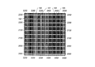
Fig. 2 illustrates the results of a seismic survey in which this process of
binning has been carried out. In the example, each bin is a square of side 25
meters.
Within each bin, in the form of a bar chart, is the source-receiver offset for
all the
traces within the bin. The source-receiver distances are plotted on a scale
that ranges
from a minimum to a maximum value that is determined by the acquisition
geometry,
CA 02308993 2000-08-16
the scale being the same for each of the bins. As can be seen in the display,
there is
considerable variation in the relative distribution of source-receiver offset
distances
within the bins. U.S. patent 5,430,689 to Rigsby shows a similar display in
which,
instead of the actual distances within a bin being plotted, a histogram is
shown
wherein ranges of distances are combined. A limitation of a display such as
Fig. 2 is
that it is not immediately obvious which of the bins have the "best" sampling
of
offset distances. The bins that stand out visually are not necessarily the
same ones
that, upon closer examination, turn out to have the most uniform distribution
of offset
distances. While bins such as 102 can be clearly seen as having a very sparse
sampling of offset distances, it is difficult, at first glance, to decide
whether, e.g., bin
100 is better than bin 101, or whether bin 104 is better than bin 105.
The present invention determines a statistical measure of uniformity of
distribution of offsets. Denoting by { xi , i = 1, 2, 3, . . . N} as the
source-receiver
offset distance within a CDP bin, it is clear that if all the distances are
uniformly
spaced, then the successive increments between the offset distances would all
be ( xN
- xl) / (N - 1). One embodiment of the invention determines the standard
deviation
of the incremental offset distances given by:
1l2
lxi+1 xi xA )
i=1
(N- 1)
(1)
In equation (1), xA is the average increment between successive offset
distances. Instead of the average, a median or a mode may also be used.
Fig. 3 shows the binned data of Fig. 2 wherein this statistical measure or
uniformity of the offset distances has been determined for each bin and the
result
displayed in a black and white approximation of a color display. In the
original, the
bins with the smallest standard deviation are shown in green, with increasing
values
7
CA 02308993 2000-08-16
going through blue, violet, yellow, pink and red. Any other coding scheme for
mapping the figure of merit to a color chart may be used. In the present
display of
Fig. 2, a cross-hatched simulation of a color display is shown. In an
alternate
embodiment (not shown) , a gray scale is used to display the figure of merit.
As can
be seen in the display, bin 202 which corresponds to 102 in Fig. 2 is in red
and has
among the largest values of the standard deviation of incremental offset
distances
while bin 200, which corresponds to bin 100 in Fig. 2 has among the smallest
standard deviation. Subtle variations, that are not evident in Fig. 2 are
clearly seen in
Fig. 3: for example, bin 200 is better than bin 201, and bin 204 is better
than bin 205.
The center of Fig. 3 has four bins in red that have their counterparts in Fig.
2. Close
examination of Fig. 2 reveals that while the distribution does appear to be
uniform in
these four bins, this is an illusion due to the fact that a number of source-
receiver
offset distances are closely replicated, so that in the bar plot of Fig. 2,
these
duplicated distances appear as a single broad line.
Those versed in the art would recognize that equation (1) would give a small
value to those bins in which, on the whole, the offset distances are uniformly
spaced.
In some processing applications, this global uniformity is not sufficient and
it is
desirable to have some local uniformity in the spacing of the offset distances
as well.
This is accomplished in another embodiment of the invention that uses, as a
figure of
merit, the second derivative of the offset distance. This may be denoted by:
N-2
( 2
~x~+z - 2x;+~ + x~
=i
N-2
(2)
Displays of this figure of merit (not shown) similar to Fig. 3 are obtained
for the
distribution of distances shown in Fig. 2. Another suitable figure of merit is
the
product of equations (2) and (3).
8
CA 02308993 2000-08-16
Those versed in the art would recognize that other statistical measures could
also be determined for a data set and appropriate color displays produced. For
example, the user may define a desired distribution of offset distances and
use a
statistical measure such as the Pearson product moment correlation coefficient
as a
figure of merit on how much the actual distribution differs from the idealized
distribution. Such variations are intended to be within the scope of the
present
invention.
In yet another embodiment of the invention, the overall survey is evaluated
for adequacy of coverage: this is in contrast to the embodiment discussed
above
which gives a visual display of the adequacy of coverage within each of a
plurality of
CMP bins. This is best understood with reference to Fig. 4.
For this evaluation, the entire data set from all the CMP gathers is sorted by
the offset distance and binned into a set of offset bins 301a, 301b. . . 301n.
Fig. 4 is
a histogram of the number of traces 303a, 303b. . . that have an offset range
within
the range defined by the corresponding bin. Given this histogram, a number of
statistical measures may be used to evaluate the survey.
One such measure that is determined in the present invention is the standard
deviation of the data represented in Fig. 4. For computing the standard
deviation,
each of the bins 301i is replaced by its midpoint value 3111 and given a
weight
proportional the number of samples 303i within the bin. If the ratio of this
standard
deviation to an ideal increment in source-receiver offset exceeds a
predetermined
value, then the survey is unacceptable. For this purpose, the ideal increment
in
source receiver offset is determined from the maximum offset in the survey and
the
total number of recording channels used for the receivers in the survey.
Another check that is made in the invention is a determination of the total
number of duplicate traces. Those versed in the art would recognize that in a
typical
3-D seismic survey, there could be many CMP bins that have more than one
source-
receiver combinations with the same offset distance. While the signal-to-noise
ratio
for random noise is reduced by having a plurality of traces, little additional
9
CA 02308993 2000-08-16
information is gained as far as imaging of the subsurface is concerned.
Accordingly,
in the present invention, duplicate traces are defined as traces with a CMP
bin that
have offset distances that are less than a prespecified fraction of the ideal
increment
and a count of such duplicate traces is maintained. In a preferred embodiment
of the
invention, this fraction is one-eighth. If the number of duplicate traces
exceeds a
prespecified fraction of the total number of traces in the survey, then the
survey is
unacceptable. In a preferred embodiment of the invention, this fraction is
20%.
Another quantity that is determined relates to the flatness of the histogram
display in Fig. 4. This measure of flatness may be understood by representing
the
histogram in Fig. 4 as a series
S= ~ n;8 (x- x;)
(3)
where ni is the number of traces in the i-th bin, x is the offset distance,
and xi is the
offset for the center of the i-th bin. The term "bin" as used with reference
to the
offset distribution is not the same as the CMP bin referred to earlier. The
standard
deviation of the set of set of numbers ni is determined and if the ratio of
this standard
deviation to the number of traces in the survey exceeds a predetermined value,
the
survey is considered unacceptable.
In another embodiment of the invention, a desired offset distribution is
specified for the entire data set and the Pearson product moment correlation
coefficient determined for the desired and actual distribution.
Fig. 5 is a display of a computer screen showing an example of the global
evaluation method. Thirteen possible acquisition geometries (the rows of data
in the
upper part of the display) were deemed acceptable. Each column corresponds to
a
different variable in the acquisition geometry. For purposes of example only,
the
display in Fig. 5 changed the inline fold, the crossline fold, the number of
channels
of recording per line, the number of receiver lines, the number of source
lines, the in-
CA 02308993 2000-08-16
line roll, the cross-line roll, the total number of channels of recording, the
line
spacing, the maximum offset, the design type, the receiver spacing and the
source
spacing. In the lower part of Fig. 5 is shown an example of the azimuthal
distribution
of data at a selected bin and a display of the offset distribution.
The graphic displays disclosed above in Figs. 1 - 3 enable the geophysicist
acquiring the seismic data to make judgments about the adequacy of the seismic
coverage. The display of Fig. 5, on the other hand, gives an objective
evaluation of
the acquisition geometries based upon predefined statistical measures of
quality. It is
not uncommon, however, for different geophysicists to disagree on a ranking of
different acquisition geometries. Recognizing that statistical measures
discussed
above are at best an approximate quantitative measure of such ranking, in
another
embodiment of the invention, a Neural Net (NN) is used to simulate the
subjective
evaluation made by one or more geophysicists.
There are two stages in the development of such a NN. The first stage is the
training stage. In the training stage, a sampling of various types of
acquisition
configurations is simulated and for each of the configurations, one or more
local and
global statistical measures of the quality of the data are determined. The
local
measures are selected from the standard deviation of the incremental offset
for one or
more CMP bins from Eq. (1), the second derivative of the offset distance for
one or
more CMP bins from Eq. (2), and the Pearson product moment correlation
coefficient for a desired distribution of offsets. The global measures are
selected
from the standard deviation of the offset distribution for the entire data
set, the
number of duplicate traces and the flatness of the offset distribution for the
entire
data set, and the Pearson product moment correlation coefficient for a desired
distribution of offsets. These statistical measures and/or the actual
distribution of
offsets in the survey are input to the NN and the NN is trained to produce an
output
that simulates the classification of the surveys by one or more geophysicists.
The classification may be a binary one ("acceptable" and "not acceptable") or
may be on a scale of acceptability. Following the training process, the NN is
11
CA 02308993 2000-08-16
validated by presenting it with statistical measures derived from other
acquisition
configurations and verifying consistency of the output of the NN with
subjective
decisions by the same one or more geophysicists. Once the NN has been
validated, it
may be used with a high level of reliability for analyzing other acquisition
configurations.
Those versed in the art would also recognize that in some applications, such
as converted wave imaging wherein the source sends out a compressional wave
that
is converted to a shear wave upon reflection at a subsurface reflector, the
reflection
point is not midway between the source and the receiver even where the
reflectors are
uniformly flat. The present invention is applicable to such types of seismic
prospecting by using a sort-point other than a CMP to define the source-
receiver
pairs that contribute to a bin. Typically, the sort point lies somewhere
between one-
half and two-thirds of the way between the source and the receiver. The CMP
gather
is thus seen to be a special case of a CSP gather in which the sort point is
one-half.
1 S The present invention includes determination of a figure of merit for such
offset
distance distributions for a CSP and obtaining displays similar to Figs. 2, 3
and 5 for
the offset. distribution of source-receiver locations that contribute to data
in a single
bin as well as statistical measures of the quality of coverage.
In many processing applications, such as 3-D migration and anisotropy
studies, it is desirable to have a uniform sampling of azimuths. The present
invention
includes determination of a figure of merit for such azimuthal distributions
and
obtaining displays similar to Figs. 2, 3 and 5 for the azimuthal distribution
of source-
receiver locations that contribute to data in a single bin.
The present invention makes it possible to analyze a number of different
acquisition geometries for seismic surveying and select one that, based upon a
suitable figure of merit, meets processing requirements involving uniformity
of
sampling of source-receiver distances and azimuths. If visual examination of
the
display shows the figure of merit to be unacceptable, then the present
invention
makes it possible to modify the shot and receiver geometry.
12
CA 02308993 2000-08-16
While the foregoing disclosure is directed to the preferred embodiments of
the invention, various modifications will be apparent to those skilled in the
art. In
particular, those versed in the art would recognize that while the description
of the
invention above includes ordering of source-receiver combinations in order of
increasing distance or azimuth, the invention would work equally well if the
ordering
were done in order of decreasing distance. It is intended that all variations
within the
scope and spirit of the appended claims be embraced by the foregoing
disclosure.
13