Note: Descriptions are shown in the official language in which they were submitted.
CA 02312017 2000-06-20
SPECIFICATION
Title of the Invention
METHOD AND APPARATUS FOR MEASURING DISPLACEMENT OF
OBJECT USING GPS
Field of the Invention
The present invention relates to a displacement
measuring method and apparatus that install a GPS receiver
in, for example, a floating body floating on the sea surface
to detect the position of this floating body in order to
measure displacement of the floating body, that is,
variations in waves.
Background of the Invention
The kinematic positioning uses a GPS (Global Positioning
System) to precisely measure the position of a receiver of
the system (precisely speaking, the position of a receive
antenna).
The kinematic positioning installs a receiver on a known
point as a reference point while allowing another receiver
to move on an unknown point, to determine a relative position
between the reference point and the moving receiver, that is,
a baseline vector in order to precisely measure variation
components of this baseline vector.
Thus, the kinematic positioning requires the reference
point. If the baseline vector is elongated, this method also
requires a large amount of analysis data to be transmitted
- 1 -
CA 02312017 2000-06-20
to maintain precision in measuring the baseline vector,
thereby increasing technical and economical burdens.
Disclosure of the Invention
It is thus an object of the present invention to provide
a method and apparatus for measuring displacement of an object
using a GPS, wherein the displacement of the object can be
measured precisely without the needs for a reference point.
To attain this object, a method for measuring
displacement of an object using a GPS according to the present
invention is characterized by operating in measuring
displacement of an object with a GPS receiver installed
thereon, to measure a distance between the GPS receiver and
a GPS satellite, then remove from this measured distance data,
distance data corresponding to a distance to a satellite orbit
to determine a variance of the GPS receiver, then determine
at least three linear equations that use three-dimensional
coordinates of the GPS receiver as unknown numbers, based on
the variances relative to at least three GPS satellites and
an azimuth and an elevation of each GPS satellite, and then
solve these simultaneous equations to determine displacement
of the GPS receiver corresponding to its variation component
quantities on three-dimensional coordinate axes.
In addition, according to a preferred embodiment of the
present invention, in the method for measuring displacement
of an object, the distance data corresponding to the distance
to the satellite orbit is obtained by subjecting the measured
distance data to a moving averaging process, or as the distance
- 2 -
CA 02312017 2000-06-20
data corresponding to the distance to the satellite orbit,
satellite orbit data itself is used.
Furthermore, according to another preferred embodiment
of the present invention, in the method for measuring
displacement of an object, the variance of the GPS receiver
is obtained by passing the measured distance data through a
high pass filter to remove distance data approximate to the
satellite orbit or subjecting the measured distance data to
a moving averaging process based on a time window larger than
or equal to a variation cycle in a measurement environment.
With the above configuration, the variances of the GPS
receiver relative to the at least three GPS satellites are
determined based on the measured distance data between the
GPS receiver and the GPS satellites and the at least three
linear equations are determined based on these variances and
the azimuth and elevation of each GPS satellite so that these
simultaneous equations are solved to determine the variance
of the GPS receiver on the three-dimensional coordinate axes .
Thus, this configuration requires no reference point in
contrast to the kinematic positioning and does not require
a large amount of measured data to be transmitted to the land
reference point for analysis with data in the reference point.
Consequently, measurement costs can be reduced and the
displacement of the object can be measured precisely.
In addition, to attain the above object, the method for
measuring displacement of an object using a GPS according to
the present invention is characterized by operating in
measuring displacement of an object with a GPS receiver
- 3 -
CA 02312017 2000-06-20
installed thereon, to measure a distance between the GPS
receiver and a GPS satellite, then remove from this measured
distance data, distance data corresponding to a distance to
a satellite orbit to determine a variance of the GPS receiver,
then determine at least four linear equations that use
three-dimensional coordinates of the GPS receiver as unknown
numbers, based on the variances relative to at least four GPS
satellites and an azimuth and an elevation of each GPS
satellite, then determine differences among the at least four
linear equations to obtain linear equations for at least three
satellite to satellite single phase differences concerning
the variance of the GPS receiver, and then solve these
simultaneous equations to determine displacement of the GPS
receiver corresponding to its variation component quantities
on three-dimensional coordinate axes.
In addition, according to a preferred embodiment of the
present invention, in the method for measuring displacement
of an object, the distance data corresponding to the distance
to the satellite orbit is obtained by subjecting the measured
distance data to a moving averaging process, or as the distance
data corresponding to the distance to the satellite orbit,
satellite orbit data itself is used.
Furthermore, according to another preferred embodiment
of the present invention, in the method for measuring
displacement of an object, the variance of the GPS receiver
is obtained by passing the measured distance data through a
high pass filter to remove therefrom distance data
approximate to the satellite orbit or subjecting the measured
- 4 -
CA 02312017 2000-06-20
distance data to a moving averaging process based on a time
window larger than or equal to a variation cycle in a
measurement environment.
With the above configuration, the variance of the GPS
receiver relative to the at least four GPS satellites is
determined based on the measured distance data between the
GPS receiver and the GPS satellites and the linear equations
for the at least three satellite to satellite single phase
differences are determined based on the above variances and
the azimuth and elevation of each GPS satellite so that these
simultaneous equations are solved to determine the variance
of the GPS receiver on the three-dimensional coordinate axes .
Thus, this configuration requires no reference point in
contrast to the kinematic positioning and does not require
a large amount of measured data to be transmitted to the land
reference point for analysis with data in the reference point.
Consequently, measurement costs can be reduced and the
displacement of the object can be measured precisely.
To attain the above object, an apparatus for measuring
displacement of an object using a GPS according to the present
invention, the apparatus measuring displacement of an object
with a GPS receiver installed thereon, the apparatus being
characterized by comprising a distance measuring section
provided in the GPS receiver for measuring distances between
the GPS receiver and a GPS satellite, a variance detecting
section for removing from measured distance data measured by
the distance measuring section, distance data corresponding
to a distance to a satellite orbit to determine a variance
- 5 -
CA 02312017 2000-06-20
of the GPS receiver, and a displacement calculating section
for determining at least three linear equations that use
three-dimensional coordinates of the GPS receiver as unknown
numbers, based on variances relative to at least three GPS
satellites determined by the variance detecting section and
on an azimuth and an elevation of each GPS satellite and then
solving these simultaneous equations to determine
displacement of the GPS receiver corresponding to its
variation component quantities on three-dimensional
coordinate axes.
In addition, according to a preferred embodiment of the
present invention, in the apparatus for measuring
displacement of an object, the distance data corresponding
to the distance to the satellite orbit is obtained by
subjecting the measured distance data to a moving averaging
process, or as the distance data corresponding to the distance
to the satellite orbit, satellite orbit data itself is used.
Furthermore, according to another preferred embodiment
of the present invention, in the apparatus for measuring
displacement of an object, the variance of the GPS receiver
is obtained by passing the measured distance data through a
high pass filter to remove therefrom distance data
approximate to the satellite orbit or subjecting the measured
distance data to a moving averaging process based on a time
window larger than or equal to a variation cycle in a
measurement environment.
With the above configuration, the variances of the GPS
receiver relative to the at least three GPS satellites are
- 6 -
CA 02312017 2000-06-20
determined based on the measured distance data between the
GPS receiver and the GPS satellites and the at least three
linear equations are determined based on these variances and
the azimuth and elevation of each GPS satellite so that these
simultaneous equations are solved to determine the variance
of the GPS receiver on the three-dimensional coordinate axes.
Thus, this configuration requires no reference point in
contrast to the kinematic positioning and does not require
a large amount of measured data to be transmitted to the land
reference point for analysis with data in the reference point.
Consequently, measurement costs can be reduced and the
displacement of the object can be measured precisely.
To attain the above object, the apparatus for measuring
displacement of an object using a GPS according to the present
invention, the apparatus measuring displacement of an object
with a GPS receiver installed thereon, the apparatus being
characterized.by comprising a distance measuring section
provided in the GPS receiver for measuring distances between
the GPS receiver and a GPS satellite, a variance detecting
section for removing from measured distance data measured by
the distance measuring section, distance data corresponding
to a distances to a satellite orbit to determine a variance
of the GPS receiver, and a displacement calculating section
for determining at least four linear equations that use
three-dimensional coordinates of the GPS receiver as unknown
numbers, based on variances relative to at least four GPS
satellites determined by the variance detecting section and
on an azimuth and an elevation of each GPS satellite,
_ 7 _
CA 02312017 2000-06-20
determining differences among the at least four linear
equations to obtain linear equations for at least three
satellite to satellite single phase differences concerning
the variance of the GPS receiver, and then solving these
simultaneous equations to determine displacement of the GPS
receiver corresponding to its variation component quantities
on three-dimensional coordinate axes.
With the above configuration, the variances of the GPS
receiver relative to the at least four GPS satellites are
determined based on the measured distance data between the
GPS receiver and the GPS satellites and the linear equations
for the at least three satellite to satellite single phase
differences are determined based on the above variances and
the azimuth and elevation of each GPS satellite so that these
simultaneous equations are solved to determine the variance
of the GPS receiver on the three-dimensional coordinate axes .
Thus, this configuration requires no reference point in
contrast to the kinematic positioning and does not require
a large amount of measured data to be transmitted to the land
reference point for analysis with data in the reference point.
Consequently, measurement costs can be reduced and the
displacement of the object can be measured precisely.
In addition, according to a preferred embodiment of the
present invention, in the apparatus for measuring
displacement of an object, the distance data corresponding
to the distance to the satellite orbit is obtained by
subjecting the measured distance data to a moving averaging
_ g _
CA 02312017 2000-06-20
process, or as the distance data corresponding to the distance
to the satellite orbit, satellite orbit data itself is used.
Furthermore, according to another preferred embodiment
of the present invention, in the apparatus for measuring
displacement of an object, the variance of the GPS receiver
is obtained by passing the measured distance data through a
high pass filter to remove therefrom distance data
approximate to the satellite orbit or subjecting the measured
distance data to a moving averaging process based on a time
window larger than or equal to a variation cycle in a
measurement environment.
With the above conf iguration, the variances of the GPS
receiver relative to the at least four GPS satellites are
determined based on the measured distance data between the
GPS receiver and the GPS satellites and the linear equations
for the at least three satellite to satellite single phase
differences are determined based on the above variances and
the azimuth and elevation of each GPS satellite so that these
simultaneous equations are solved to determine the variance
of the GPS receiver on the three-dimensional coordinate axes.
Thus, this configuration requires no reference point in
contrast to the kinematic positioning and does not require
a large amount of measured data to be transmitted to the land
reference point for analysis with data in the reference point.
Consequently, measurement costs can be reduced and the
displacement of the object can be measured precisely.
_ 9 _
CA 02312017 2000-06-20
Various features and effects of the present invention
will be apparent from embodiments, which will be described
based on accompanying drawings.
Brief Description of the Drawings
FIG. 1 is a diagram showing a general entire configuration
of a displacement measuring apparatus according to a first
embodiment of the present invention;
FIG. 2 is a block diagram showing a general configuration
of the displacement measuring apparatus according to the
first embodiment of the present invention;
FIG. 3 is a waveform diagram showing measured distance
data in a displacement measuring method according to the first
embodiment of the present invention;
FIG. 4 is a waveform diagram showing variance in the
displacement measuring method according to the first
embodiment of the present invention;
FIG. 5 is a waveform diagram showing variance in the
displacement measuring method according to the first
embodiment of the present invention;
FIG. 6 is a waveform diagram showing displacement in the
displacement measuring method according to the first
embodiment of the present invention;
FIG. 7 is a diagram showing a general entire configuration
of a displacement measuring apparatus according to a
variation of the first embodiment;
- 10 -
CA 02312017 2000-06-20
FIG. 8 is a diagram showing a general entire configuration
of a displacement measuring apparatus according to a
variation of the first embodiment;
FIG. 9 is a diagram showing a general entire configuration
of a displacement measuring apparatus according to a
variation of the first embodiment;
FIG. 10 is a diagram showing a general entire
configuration of a displacement measuring apparatus
according to a second embodiment of the present invention;
FIG. 11 is a diagram showing a general entire
configuration of a displacement measuring apparatus
according to a variation of the second embodiment;
FIG. 12 is a diagram showing a general entire
configuration of a displacement measuring apparatus
according to a variation of the second embodiment; and
FIG. 13 is a diagram showing a general entire
configuration of a displacement measuring apparatus
according to a variation of the second embodiment.
Description of the Embodiments
The description of embodiments focuses on detection of
a tsunami, high seas or the like based on measurement of
displacement of a floating body (an object) such as a buoy
which floats on the sea surface ( including the water surface ) ,
using a GPS receiver installed in the floating body. The
present invention is not based on relative positioning but
on single-point positioning; precisely speaking, this
positioning is referred to as Point precise Variance
- 11 -
CA 02312017 2000-06-20
Detection (PVD) based on one-way carrier phases from a single
GPS receiver.
FIGS. 1 to 6 are useful in explaining a method and
apparatus for measuring displacement of an object using a GPS
according to a first embodiment of the present invention.
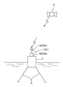
First, a general entire configuration of the
displacement measuring apparatus will be described based on
the general view in FIG. 1 and the block diagram in FIG. 2.
This displacement measuring apparatus comprises a GPS
receiver (comprising a receive antenna la and a receiver main
body lb) 1 installed in a floating body F moored at a
predetermined position on the sea surface by means of, for
example, a mooring rope K, a distance measuring section 2
installed in the GPS receiver 1 for measuring a distance to
a GPS satellite (hereafter simply referred to as a
"satellite") S, a variance detecting section 3 for
subtracting an orbital distance to a satellite orbit from the
distance data measured by the distance measuring section 2
to determine a variance of the GPS receiver 1, a disturbance
effect-removing section 4 for receiving an input of the
variance data obtained by the variance detecting section 3,
and removing the effect of wind waves, and a displacement
calculating section 5 for receiving an input of the variance
[the magnitude of a variation vector of the GPS receiver 1
relative to the satellite ( this vector is obtained by mapping
a true variation vector corresponding to actual movement of
the GPS receiver 1, to a direction vector relative to the
satellite)] to determine variation component quantities in
- 12 -
CA 02312017 2000-06-20
three-dimensional coordinate axis directions of the GPS
receiver 1, that is, the x, y, and z axes thereof, the variation
component quantitiescorresponding to the displacement of the
GPS receiver 1.
Next, each of the above components will be described in
detail with the displacement measuring method.
The distance measuring section 2 counts carriers for
electric waves from a predetermined satellite which are
received by the GPS receiver 1, to measure a distance (a
carrier phase ) between the predetermined distance and the GPS
receiver (precisely speaking, this is a distance to a receive
antenna la, but the following description refers to the
distance to the GPS satellite).
FIG. 3 shows a waveform of measured distance data measured
by the GPS receiver 1. The measured distance data has
superposed thereon phase variations caused by wind waves. In
addition, although FIG. 3 shows an L1 carrier and an L2 carrier,
either of them can be used and other signals contained in the
L1 carrier can also be used.
The variance detecting section 3 comprises a moving
averaging process section 11 for receiving an input of the
measured distance data obtained by the distance measuring
section 1, to take an average of movements of several tens
of samples in order to obtain distance data corresponding to
satellite orbit distance, and a variance calculating section
12 for subtracting from the original measured distance data,
the averaged distance data obtained by the moving averaging
process section 11, that is, the satellite orbit distance to
- 13 -
CA 02312017 2000-06-20
determine the variance of the GPS receiver 1 relative to the
satellite.
FIG. 4 shows a waveform of the variance obtained by the
variance calculating section 12, that is, a waveform of a
variation state of the GPS receiver 1. Variations of this
variance having a low frequency represent noise arising from
fluctuations in a clock in the GPS receiver 1 or the like,
while variations at a high frequency represent variations in
the GPS receiver 1, that is, the floating body caused by wind
waves.
The disturbance effect-removing section 4 removes wind
wave-induced variations by passing an input through a
bandpassfilter that cuts frequency components corresponding
to wind waves . FIG. 5 shows a waveform obtained by means of
passage through the bandpass filter.
The displacement calculating section 5 creates three
linear equations that use three-dimensional coordinates of
the GPS receiver 1, based on each variance free from
disturbances which has been obtained based on measured
distance data from three satellites and on an azimuth and an
elevation of each satellite, and solves ternary linear
simultaneous equations to determine variation component
quantities of the GPS receiver 1 at three-dimensional
coordinates, that is, displacement (X, Y, Z).
Specifically, using the three-dimensional coordinate
components ( x, y, z ) , a variance P" obtained from a carrier
from a satellite r~ is expressed by:
P" = a"x + bny + caz . . . ( 1 )
- 14 -
CA 02312017 2000-06-20
where:
a~~ = C~$~E~n ) $InttlGn
bn = cos~El" ) $ln~Az"
C~~ _ $lll~l~Zn )
and Az~ and E1" denote the azimuth and elevation of an n-
th satellite.
Consequently, three satellites (n = 1, 2, 3) are used
to obtain the ternary linear simultaneous equations shown by
Equation (2), shown below. By solving these simultaneous
equations, the displacement of the GPS receiver 1 can be
determined.
P1 =alx+bly+clz
Pz =aZx+b2y+c2z ....
P3 =a3x+b3y+C3Z
A displacement in the z axis direction obtained by solving
the simultaneous equations in Equation ( 2 ) is shown in FIG.
6 by a solid line. For comparison, a result of measurement
based on the real-time kinematic ( RTK ) method is shown by a
broken line. The two lines align substantially, indicating
that the accuracy of measurements based on the above described
single-point positioning method is almost as high as that
based on the relative positioning method.
Of course, displacements X and Y are determined in the
x- y-, and z-directions, respectively, so that these
displacements X, Y, and Z can be used to measure a tsunami.
The conditions of a surge can simply be measured based on the
displacement in the z axis direction.
- 15 -
CA 02312017 2000-06-20
In this manner, the distance between the satellite and
the GPS receiver installed in the floating body is measured,
and data on the distance to the satellite orbit which is
obtained by averaging the measured distance data is
subtracted from the above measured distance data to determine
the variance of the GPS receiver. Furthermore, this variance
is passed through the bandpass filter to remove therefrom wind
wave-induced noise, and ternary linear simultaneous
equations are created using variances relative to, for
example, three satellites and the azimuth and elevation of
each of the satellites. Finally, the ternary linear
simultaneous equations are solved. Consequently, the
displacement of the floating body with the GPS receiver 1
installed therein can be determined precisely, thereby
accurately determining the occurrence and magnitude of a
tsunami as well as the conditions of a surge.
That is, the above described displacement measuring
method and apparatus can precisely measure the displacement
of the floating body while reducing measurement costs because
the reference point is not required in contrast to the
kinematic positioning and because a large amount of measured
data need not be transmitted to the land reference point for
analysis with data in the reference point.
Variations of the first embodiment will be described
below.
Although in the above first embodiment, the variance
detecting section 3 determines the satellite orbit by
subjecting the measured distance data to the moving averaging
- 16 -
CA 02312017 2000-06-20
process, for example, data on the satellite orbit itself can
be used instead.
In this case, in place of the moving averaging section
11 shown in the block diagram in FIG. 2, a data storage section
21 for storing satellite orbit data is provided as shown in
FIG. 7 so that satellite orbit data from the data storage
section 21 can be used to calculate variances.
In addition, in the first embodiment, the variance
detecting section 3 first determines the orbit of the
satellite and then subtracts the satellite orbit data from
the measured distance data to determine the variance of the
GPS receiver 1 . The variance, however, can also be determined
within a signal process by, for example, passing the measured
distance data through a high pass filter to remove therefrom
components that are approximate to the satellite orbit data
and that are similar to a direct current. Specifically, those
components that are similar to a direct current are removed
by fast Fourier transformation, band cutting, or inverse fast
Fourier transformation.
In this case, in place of the moving averaging process
section 11 and variance calculating section 12 shown in the
block diagram in FIG. 2, a filter section 31 comprising a high
pass filter is used as shown in FIG. 8.
In addition, although in the first embodiment, the
variance detecting section 3 determines the variance of the
GPS receiver 1 and the disturbance effect-removing section
4 removes the effect of wind waves, a variance free from the
effect of wind waves can be obtained by, for example,
- 17 -
CA 02312017 2000-06-20
subjecting the measured distance data obtained by the
distance measuring section 2, to a moving averaging process
based on a time window larger than or equal to ( for example,
about 11 seconds ) a wave period ( an example of a wave period
in the measurement environment) to obtain distance data
corresponding to the satellite orbit distance, and
subtracting from the original measured distance data the
averaged distance data obtained through this moving averaging
process based on the time window. That is, this moving
averaging process based on the time window eliminates the
needs for the configuration for removing the effect of
disturbances (the disturbance effect-removing section).
In this case, as shown in FIG. 9, the disturbance effect
removing section 4 shown in the block diagram in FIG. 2 is
removed, a moving averaging process section 4l carries out
the moving averaging process based on the time window, and
a variance calculating section 42 subtracts the averaged
distance data from the measured distance data and inputs the
result directly to the displacement calculating section 5.
In addition, in the description of the first embodiment
and each of the above described variances, the displacement
calculating section 5 uses the variances obtained from the
three satellites to determine the displacements in the x-,
y-, and z-axis directions of the GPS receiver. However,
variances obtained from, for example, four or more (n)
satellites can also be used.
In this case, as shown in Equation (3), shown below,
equations are created for n_ variances Pn so that the least
- 18 -
CA 02312017 2000-06-20
square method can be applied to obtain more reliable
displacements, as shown in Equations ( 4 ) and ( 5 ) , shown below.
PI = alx + bly + clz
PZ =a2x+b2y+c2z
Pn =anx+bny+cnz ~...~3~
PN =aNx+bNy+cNz
in the case of n=1, 2, ..., N
O= ~~~anx+bny+cnz-pn)2
n=1
=2 \LJanlx+~~bnan~y+\LJCnanlZ-~~Pnan~
n 1 n=1 n=1 n 1
O= ~ ~~anx+ n +cnz-Pn)z
~y n=1
N l N 1 / N l N 1
2 a b x+~~bn~y+~~Cb z ~~Pbn~
O= ~~~anx+bny+cnz-P~2
n=1
=2 anon x+ ~bnCn~y+~~Cn z-~~Pcn~
n L n=1 n=1 n=1
~Pnan (~anlx+ f ~bnan~y+~~cnanlZ
n=1 \n=1 / \n=1 / \n=1 /
~Pnbn =~~a b x+~~bn~y+~~Cb Z .. 5
n=1 n=1 n=1 n=1
iI PnCn = ~~anCn~x+~~bnCn~y-f' ~~Cn~Z
n=L n=1 n=1 n=1
FIG. 10 is a diagram useful in explaining a method and
apparatus for measuring displacement of an object using a GPS
according to a second preferred embodiment of the present
invention.
- 19 -
CA 02312017 2000-06-20
In the first embodiment, the displacement calculating
section creates the ternary linear simultaneous equations
using the variances or the like determined from the three
satellites. In the second embodiment, a displacement
calculating section 55, shown in FIG. 10, determines four
linear equations that use three-dimensional coordinates of
a GPS receiver 51, based on variances as well as azimuths and
elevations determined from at least four satellites,
determines differences among the four linear equations to
obtain linear equations for three satellite to satellite
single phase differences concerning the variance of the GPS
receiver, and solves these simultaneous equations to
determine displacement of the GPS receiver corresponding to
its variation component quantities in the three-dimensional
coordinate axis directions.
Since this embodiment has the same basic configuration
as the first embodiment, it will be generally explained with
reference to FIGS. 1 and 10.
This displacement measuring apparatus comprises a GPS
receiver (comprising a receive antenna 51a and a receiver main
body 51b) 51 installed in a floating body F moored at a
predetermined position on the sea surface by means of, for
example, a mooring rope K, a distance measuring section 52
installed in the GPS receiver 51 for measuring a distance to
a GPS satellite S, a variance detecting section 53 for
subtracting an orbital distance to a satellite orbit from the
distance data measured by the distance measuring section 52
to determine a variance of the GPS receiver 51, a disturbance
- 20 -
CA 02312017 2000-06-20
effect-removing section 54 for receiving an input of the
variance data obtained by the variance detecting section 53,
and removing the effect of wind waves therefrom, and a
displacement calculating section 55 for receiving an input
of the variance obtained in the disturbance effect-removing
section 54 [the magnitude of a variation vector of the GPS
receiver 1 relative to the satellite (this vector is obtained
by mapping a true variation vector corresponding to actual
movement of the GPS receiver 51, to a direction vector relative
to the satellite)] to determine variation component
quantities in three-dimensional coordinate axis directions
of the GPS receiver 51, that is, the x, y, and z axes thereof;
the variation component quantities corresponding to the
displacement of the GPS receiver 51.
The variance detecting section 53 comprises a moving
averaging process section 61 for receiving an input of the
measured distance data obtained by the distance measuring
section 52, to take an average of movements of~ several tens
of samples in order to obtain distance data corresponding to
satellite orbit distances, and a variance calculatingsection
62 for subtracting from the original measured distance data,
the averaged distance data obtained by the moving averaging
process section 61, that is, the satellite orbit distance to
determine the variance of the GPS receiver 51 relative to the
satellite.
The displacement calculating section 55 receives an
input of the four variances P1 to P4 obtained by the variance
detecting section 53 to determine the four linear equations
- 21 -
CA 02312017 2000-06-20
shown in Equation ( 6 ) , shown below, based on these variances
and the azimuth and elevation of the GPS receiver relative
to each satellite, and then determines three linear equations
based on star-like satellite to satellite single phase
differences as shown in Equation (7), shown below.
P~ = alx + b~ y + clz
Pz =azx+bzy+czz
P3 = a3x + bay + C3Z ~ .
P4 = a4x + b4y + C4Z
P~ _ Pa = ~a ~ _ a4 ~x + ~b~ _ b4 ~Y + ~c~ _ ca ~z
Pz - Pa = ~az - aa~x + lbz - ba~Y + lcz - ca~z
P3 P4 _ \a3 a4 /x + \b3 b4 /Y + \C3 C4 /Z
If cyclic satellite to satellite single phase
differences are used, simultaneous equations such as those
shown in Equation (8), shown below, are obtained.
P~-Pz =~a~-az~x+~b~-bz~Y+~c~-cz~z
PZ _ 173 = (a2 _ a3 lx + lb2 _ b3ly + (CZ _ C3lZ .. . (g
P3 P4 = \a 3 a4 /x + \~b3 b4 /~Y + ~C3 C4 J~Z
By solving the simultaneous equations based on the three
satellite to satellite single phase differences and
concerning the variance of the GPS receiver, the variance of
the GPS receiver on the three-dimensional coordinate axes (X,
Y, Z) is determined.
If the variance of the GPS receiver is determined based
on n satellite to satellite single phase differences, a
reliable displacement is obtained using the least square
method as shown in Equations (9) and (10), shown below.
- 22 -
CA 02312017 2000-06-20
[\an aN lx + \Un 6N lY \Pn PN )J2
+ \Cn CN lZ
n.l
2 ( ~
~ y + ~ \Cn CN /\an
an aN Z
- 1
C1N
x
+
1
(ln
-
bN
an
-
QN
x n-L n-
n-1
P
a
P
a
N
N
l\
n
\
n
n~l
[(an \Pn PN )~2
aN
lx
+
~~n
bN
ly
+
\Cn
CN
JZ
n.l
N-1 N-1
N-1 +~~~Cn -CN~~n -~N)
2 Z
~~an \
-aN)~~n
-UNlx+
~~~n
-~N)
IY
/
_
2 -
~~~n
-
~N~~n
-~N~
n.l
2
_ \Pn PN )J
~
~
[(an
aN
lx
+
~~n
uN
ly
+
\Cn
CN
lZ
~~\an
aNl\Cn
CN~~x+~~\bn
bNllCn
CN~~.Y+~~lCn
CN)Z~Z
-1
n
1
_ n.l
~ n
~N1/
\/
,
P
P
C
C
n
n
N
l
N
l\
LJ
\
n.l
~~P - PN~an -aN
n~ 1
an aNl2)x+~~~~n UN an aN y+ Cn CN~an aN)/Z
(Pn PN ~~n ~N
n-1 ........(10)
~an - aN ~bn - uN ) x + ~ ~bn - bN ~2 Y + it \Cn - CN ~bn - UN' Z
n~l ~ ~ n~l ~ ~ n.l
\P PN I \Cn CN
n.l
_ ~ ~1(Rn - C1N ~Cn - CN )~ x + ~ bn tJN Cn CN y + Cn CN 2 Z
The displacement measuring method and apparatus
according to the second embodiment does not only provide the
same effects as the first embodiment but also uses the measured
distance data based on the satellite to satellite single phase
differences to eliminate the need to remove errors
- 23 -
CA 02312017 2000-06-20
originating from measuring instruments, that is, low
frequencies such as fluctuations in the clock of the GPS
receiver or the like, thereby simplifying the configuration
thereof or the like.
The four variations described in the first embodiment
are also applicable to the second embodiment.
That is, in the second embodiment, the variance detecting
section 53 determines the satellite orbit by subjecting the
measured distance data to the moving averaging process, but
for example, the satellite orbit data can also be used
directly.
In this case, in place of the moving averaging process
51 shown in the block diagram in FIG. 10, a data storage section
71 that stores satellite orbit data is provided as shown in
FIG. 11 so that satellite orbit data from the data storage
section 71 can be used to calculate the variance.
Additionally, in the second embodiment, the variance
detecting section 53 first determines the satellite orbit and
subtracts the satellite orbit data from the measured distance
data to determine the variance of the GPS receiver 51. The
variance, however, can be determined within a single process
by, for example, passing the measured distance data through
a high pass filter to remove therefrom components that are
approximate to the satellite orbit data and that are similar
to a direct current. Specifically, those components that are
similar to a direct current are removed by fast Fourier
transformation, band cutting, or inverse fast Fourier
transformation.
- 24 -
CA 02312017 2000-06-20
In this case, in place of the moving averaging process
section 61 and variance calculating section 62 shown in the
block diagram in FIG. 10, a filter section 81 comprising a
high pass filter is used as shown in FIG. 12.
In addition, although in the second embodiment, the
variance detecting section 53 determines the variance of the
GPS receiver 51 and the disturbance effect-removing section
54 removes the effect of wind waves, a variance free from the
effect of wind waves can be obtained by, for example,
subjecting the measured distance data obtained by the
distance measuring section 52 , to a moving averaging process
based on a time window larger than or equal to ( for example,
about 11 seconds ) a wave period ( an example of a wave period
in the measurement environment) to obtain distance data
corresponding to the satellite orbit distance, and
subtracting from the original measured distance data the
averaged distance data obtained through this moving averaging
process based on the time window. That is, this moving
averaging process based on the time window eliminates the
needs for the configuration for removing the effect of
disturbances (the disturbance effect-removing section).
In this case, as shown in FIG. 13, the disturbance effect
removing section 54 shown in the block diagram in FIG. 10 is
removed, a moving averaging process section 91 carries out
the moving averaging process based on the time window, and
a variance calculating section 92 subtracts the averaged
distance data from the measured distance data and inputs the
result directly to the displacement calculating section 55.
- 25 -
CA 02312017 2000-06-20
In addition, in the description of the second embodiment
and each variation relating thereto, the displacement
calculating section 55 uses the variances obtained from the
at least four satellites to obtain equations for the at least
three satellite to satellite single phase differences to
determine the displacements in the x-, y-, and z-axis
directions of the GPS receiver. However, based on variances
obtained from, for example, five or more (n) satellites,
linear equations for at least four satellite to satellite
single phase differences can be used to determine a variance
corresponding to the resulting variation components.
In this case, as in the first embodiment, equations are
created for n-1 satellite to satellite single phase
differences so that the least square method can be applied
to obtain more reliable displacements.
The above described displacement measuring method and
apparatus according to the first and second embodiments can
be used to construct reliable disaster prevention systems and
ship navigation support systems, thereby significantly
contributing society.
Additionally, although the f first and second embodiments
have been described in conjunction with measurements of the
displacement of the floating body, the present invention is
not limited to this . In this case, as the wave period applied
to the above described time window, an appropriate cycle for
a measured object, for example, a variation cycle in the
environment of the measured object may be used.
- 26 -