Note: Descriptions are shown in the official language in which they were submitted.
CA 02316170 2000-06-22
WO 98/29758 PCTIUS97123864
COMMUNICATIONS LOCALIZATION SYSTEM
BACKGROUND AND SUMMARY OF THE INVENTION
The present invention is directed to determining the geographic location of
a mobile radio communications transmitter that is part of a wireless cellular
s communications system so as to facilitate emergency service responses,
roadside
.assistance, traffic monitoring, or other services that can apply or be
supported by the
location information.
Cellular-telephone systems now provide ready access to wireless telephone
communications. Cellular telephones typically operate in an analog system of
io frequency division multiple access (FDMA). Digital technologies, including
time
division multiple access (TDMA) or code division multiple access (CDMA), offer
greater capacity and should give more individuals simultaneous access to
cellular
telephone services. In addition, "cellular-like" communications systems, such
as a
personal communication system (PCS), may further increase the number of
i s individuals with access to a wireless communication network.
A cellular-telephone or cetlular-like communication system is a system with
a network of fixed base stations serving local areas (i.e., "cells") providing
an
integrated communication service to a plurality of mobile transmitteNreceiver
("transceiver") units, e.g., cellular telephones. Such a communications
network
2 o attempts to communicate with each transceiver from the base station which
provides
the optima! communication. The optimal base station is usually, but not
necessarily,
the one nearest the mobiie transceiver. To provide the optimal communications
support, the network need not locate the geographic position of the mobile
transceiver more accurately than needed to determine which base station to
use.
25 The inability of existing communication networks for cellular-telephone or
cellular-like communication systems to accurately determine the location of a
mobile
transmitter is a major disadvantage in an emergency. For example, public
safety
officials in Los Angeles estimate that, today, a quarter of all who call the
emergency
number ("9-1-1 ") from a cellular telephone do not know where they are when
they
-1-
SUBSTITUTE SHEET (RULE 26)
CA 02316170 2000-06-22
wo 9sn9~ss rcr~rs9~n3ss~
indicate that in excess of sixty percent of traffic fatalities in the United
States occur
on rural roadways. Delays caused by uncertainty in location exacerbate the
inherently longer response times for providing emergency services in rural
areas.
The problem of locating the position of a mobile radio transceiver has been
solved in many ways for many years but in systems other than that of a
cellular-
tetephone or cellular-like communication system. No simple, low-cost solution
has
been found that is practical when applied to the wide-scale monitoring of
mobile
telephones. One practical difficulty in implementing any type of localization
for
mobile radio transceivers is the cost of the modifications either to the
transceiver or
i o to the communications network (infrastructure) that are needed to
determine the
location of the mobile transceiver. Any given tra nsceiver would rarely, if
ever, be
used in placing a request for emergency or roadside assistance. Thus, the
suppliers
of transceivers and the operators of communications networks have little
economic
incentive to increase the complexity (and cost) of the transceivers or to
install an
i5 extensive and expensive infrastructure to support such rarely used services
absent
government mandate. However unprofitable in the short term, the value of
emergency assistance and roadside assistance services have unquestionable
value
for providing and enhancing personal and public safety. Ameliorating the
increasing
incidence of violence and the related, growing concern for personal security
with a
2 o mobile communications system is a worthy policy goal with the potential
for realizing
enormous benefit to subscribers, network operators, and the general public
alike.
However, realizing the objective, even one s~ important and valuable, requires
a
practical, inexpensive infrastructure for uniquely identifying people
requesting or
reporting the need for assistance, communicating with them, and providing
their
2 s locations to a responding assistant.
Techniques exist for accurately determining one's position in applications
other than that of providing emergency or roadside assistance. For example,
the
-2-
SUBSTtTUTE SHEET (RULE 26~
CA 02316170 2000-06-22
WO 98129758 PCT/US97/23864
satellite-based Global Positioning System (GPS) allows determination of the
location
of the point of GPS signal reception with a special-purpose receiver for the
wireless
GPS signals that are broadcast from the satellites. However, obtaining the
position
of a communications transceiver by using GPS requires the mobile transceiver
to
include a GPS receiver. GPS receivers are expensive. Even if their cost were
to be
reduced through mass production, GPS receivers would still have to be
integrated
with ail existing and future mobile transceivers. The cost associated with
this
solution seems to be prohibitive in view of the infrequency of use of the
service and
especially in terms of the large number of mobile transceivers already in use
both in
i o the U.S. and abroad for which the localization capability Is desired.
Techniques also exist for locating the position of mobile communications
transceivers by passively monitoring their radio emissions. However, with the
simplest of approaches, radio localization does not take into consideration
the
distortions in apparent location caused by multipath interterence
(multipathing).
i 5 Muitipathing involves radio signals bouncing off of objects such as
vehicles,
buildings, hillsides, etc. Without consideration of these effects, the
apparent position
of the transceiver will be distorted. Multipath propagation is common for
short-
wavelength, radio communications since relatively smaller objects can reflect
substantial amounts of the transmitted signals, and it is especially common in
cities
2 o with buildings reflecting the signals. The potential, multipath-induced
distortions in
the apparent position of the mobile transceiver is therefore a problem that
must be
addressed in passively localizing radio emitters ~.o support applications such
as the
provision of emergency or roadside assistance.
Multipath propagation conditions need not impede locating a transceiver
2s when signal analysis and source localization procedures are used to
ameliorate
potential distortions in apparent position. For example, United States Patent
No.
4,728,959 to Maloney et aL demonstrates how direction finding procedures, by
which the direction angle of the arrival (DOA or AOA) of a signal can be
measured,
can be applied with two or more receiving base stations. Using the passive
-3-
SUBSTITUTE SHEET (RULE 26)
CA 02316170 2000-06-22
WO 98/29758 PCT/US97/23864
monitoring of communication signals that is described in this patent to
determine
location is an excellent application in that it allows for locating a mobile
transceiver
anywhere in a service area of a network having at least two receiving stations
of
known location. The direction finding approach is simple and accurate, but
requires
a directional antenna at each receiving site. With similar attention to
muitipath
effects, the requirement far direcfionat antennas can be mitigated by the use
of time-
difference-of arrtval (TDOA) measurements, which can be obtained with omni-
directionai antennas and with accurate time-base maintenance facilities.
Localization with TDOA measurements requires reception at three or more sites,
1 o since each pair of sites only enables one TDOA measurement, and each TDOA
measurement onty specifies a hyperbola (in two dimensions) along which the
transmitter can be. Even in a multipath-affected environment, TDOA
measurements
with at least a triplet of receiving sites can be analyzed to obtain
transmitter
locations. However, the necessity of requiring joint reception of a common
signal at
three or more sites with time-maintenance facilities can increase the
complexity and
cost of the TDOA approach beyond what some cellular telephone or PCS
companies are currently or may be willing to accept.
Often, in addition to timing and directional data that can be derived from
received signal characteristics, other information is available or can be
obtained that
2 o relates to the position of a mobile radio transceiver. For example, in a
system
designed to provide emergency roadside assistance. we may presume that the
person requesting assistance is in a vehicle that is on or near a road. Such a
presumption may be verified, for example, by asking the person placing the
call if he
or she is on a road. This type of additional geographic or topological
information,
2 s called here "collateral information," is of a type that is normally
available to a
dispatcher. Combining collateral information with the timing information from
two
(rather than three or more) base stations can define the location of a mobile
radio
transceiver well enough to make it possible to dispatch emergency and roadside
assistance services. The derivation of the position of the transceiver solely
from
_Q_
SU8ST1TUTE SHEET (RULE 26)
CA 02316170 2000-06-22
WO 98/29758 PClYUS97/23864
observed characteristics of its radio emissions received at two sites is
adequate, and
the need for additional base stations to derive location thus becomes
redundant.
However, no proposal to date has sought to use such collateral infomzation to
make
redundant the need for additional base stations.
Monitoring mobile transceivers that are located on vehicles has advantages
other than providing support for responses to requests for assistance. One
such
advantage is enabling the cost effective monitoring of traffic flow. Unplanned
traffic
incidents ("traffic jams") clog the highways with a resulting deleterious
effects on
safety, environment, and economy. The volume of message traffic in a major
i o metropolitan area is a type of collateral information, and it can be
combined with
observed location- and speed-related information and topographic information
(e.g.,
road maps), to indicate which roads are passable and which are congested.
However, traffic flow information, emergency services, and roadside
assistance, are
not the primary reason for establishing a communication system and thus are
not
1s provided currently by communications systems. The cost of adding equipment
to
the communications infrastructure to provide traffic flow information seems
justifiable
to communications companies only if it can be done using the most modest of
infrastructure enhancements.
Today, techniques exist that provide partial and complex solutions to the
2o problem of providing geographical locations with sufficient accuracy to aid
emergency and roadside assistance personnel. However, such systems rely on
observed information derived from two or more directional receptions, and
three or
more time-tagged receptions of radio emissions, or on navigation information
from
devices extraneous to the communications transceiver. No system seeks to
obtain
2s location information from the combination of observed timing information,
derived
from only a pair of communications radio receptions, with collateral
information
obtained, for example, from street maps. Therefore, it is an object of the
present
invention tc provide a simple and effective way to identify and locate a
mobile radio
transceiver in any wireless communication system, including chose already
existing
_5_
SUBSTITUTE SHEET (RULE 28)
CA 02316170 2005-06-20
or that a:e contemplated, such as those for personal communication systems
(PCSs), cellular telephones, specialized mobile radios (SMRs), and personal
digital
assistants (PDAs). It is an object of the present invention to provide an
automatic
location identification (AI.I) and an automatic "number" identification (ANI)
that
facilitates national and intemationai rural and urban emergency notifcation
and
personal security, and roadway monitoring by combining observed information
derived from received radio emissions with collateral information derived from
street
maps, user descriptions, and other infomzatian sources.
It is also an objective of the present invention to include: providing a
system
io in which location and identification are provided cheaply as adjuncts to
communications far national and international wireless enhanced 9-1-1 (E9-1-1
)
emergency and routine roadside assistance notiftcation; estimating roadway
speed
and provicing general transportation infom~ation such as traffic congestion
and flow
characte~zation; providing such capability in a system which is both
relatively easy
to deploy and inexpensive to construct; providing a system which has a
transportable configuration and, therefore, can be used to temporarily monitor
focalizeo regions such as road construction areas or the localities of special
events
such as spflrting competitions, conventions, or concerts; providing a
combination of
processes and attributes to form an inexpensive yet robust system for
localization
zo and identification as an adjunct to a communications system.
In an aspect of the invention, there is provided a system for locating a
mobile radio
communications transceiver in an operating environment served by a wireless
communications system. The system has first and second sensors stations of
known
location that each receive a radio signal from the mobile transceiver, a
timing processing
unit that determines time difference of signal arrival information based on
the radio signal
received at the first and second sensor stations to identify loci of possible
locations of the
mobile transceiver, and a position processing unit that determines a probable
position of
the mobile transceiver on the loci based on collateral information, wherein
the collateral
-6-
21420397.1
CA 02316170 2005-06-20
information is related to a location of the mobile transceiver and extraneous
to the time
difference of signal arrival information.
In another aspect of the invention, there is provided a method for locating a
mobile
transceiver in a wireless communications system that includes a first and
second sensor
station having known locations, the method comprising the steps of (a)
receiving, at the
first and second sensor stations, a radio signal from the mobile transceiver,
(b) determining
time difference of signal arrival information based on the radio signal
received at the first
and second stations to identify loci of possible location of the mobile
transceiver, (c)
accessing collateral information related to a location of the mobile
transceiver, said
collateral information being extraneous to the time difference of signal
arrival information,
and (d) determining a probable position of the mobile transceiver on the loci
based on the
collateral information.
The present invention provides an apparatus for locating a mobile radio
~mmunications transceiver in a wireless communications system that comprises
two sensor stations of known location, each sensor station having a receiving
antenna to receive a radio signal from the mobile transceiver, a clock
mechanism
such as a GPS-based receiver to maintain a synchronous inter-site time
standard, a
signal characterization processing unit for determining the time of arrival
(TOA) of a
specific component of the radio signal transmitted from the mobile radio
transceiver
to the sensor station, a source of collateral information about other signal
characteristics or the environment of operation of the mobile transceiver, a
-6a-
21420397.1
CA 02316170 2000-06-22
WO 98129758 PGTIUS97I23864
multidimensional parametric correlation processing unit far determining a
probable
position of the mobile transceiver from TDOA and associated collateral
information,
and an output indicative of the probable position of the mobile transceiver.
The present invention provides for locating a mobile radio transceiver in a
cellular-telephone or cepular-like communications system using a simplified
system
for passively monitoring signals emitted by the mobile transceiver. in this
invention,
the processing at two receiving base stations of known location with inter-
site
synchronization determines a TDOA locus (e.g., two dimensional hyperbola) for
the
mobile transceiver location. This TDOA locus is then combined with collateral
i o information to determine the likely location of the transceiver. The
present invention
has particular applicability to roadway transportation in that it facilitates
emergency
(9-'i-1 ) services and roadside assistance, and it permits the passive
monitoring of
traffic flow. The collateral information includes location information derived
from
other than radio location methods. Such information can include the
topological
i5 information of a map of the roadways in the area of the base station, or
other
information such as derived speed, if any, of the transceiver, or information
obtained
from communications from the caller in person or from equipment at the caper's
location.
The present invention does not require determining position by combining
2 o two or more equivalent hyperbola from three or more base stations; two
base
stations can be enough. This capability may have particular usefulness in a
CDMA
communications network in which increased capacity is obtained through dynamic
power control so that fewer base stations are likely to receive a
transceiver's
emissions. Nevertheless, there is nothing in the present invention that
precludes
25 using more than two base stations to further confrm the accuracy of a
location or to
permit locating mobile radio transceivers for which collateral information is
not
otherwise available. The ability to determine location from two sites using
TOAlTDOA methodology has particular benefit for providing emergency assistance
in that two-site reception is applicable in more environments, requires less
SUBSTITUTE SHEET (RULE 26)
CA 02316170 2000-06-22
WO 98129758 PCT/ITS97/23864
infrastructure, and offers greatly reduced cost. The present invention is
particularly
useful for monitoring traffic in rural areas, where there are fewer roads with
cells
often located close to roads, and whose signal capture at three or more sites
is
highly unlikely. Thus, in nrral areas, collateral information in the form of
roadway
s topology better indicates the location of the mobile transceiver along the
observed
TDOA locus (hyperbola). The present invention also provides a method and
apparatus for locating a mobile radio transceiver in a wireless communications
system, comprising two or more sensor stations of known location, a method and
means for determining a TDOA locus for the mobile radio communications
i a transceiver, and a method and means for combining collateral information
with the
TDOA locus to determine the location of the mobile radio transceiver.
The present invention has the aavantage of being able to determine the
location of a mobile radio transceiver without requiring an embedded or
integrated
special-purpose device, such as a GPS receiver, with the mobile transceiver.
151ndeed, the present invention enables the localization of all existing
cellular
telephones. The cost of deploying a location system of the aresent invention
is low.
This low start up cost means that the system can be deployed faster so that
consumers can realize the benefits sooner and at less expense.
BRIEF DESCRIPTION OF THE DRAWINGS
2 o Fig. 1 illustrates the locations of a cellular telephone transceiver that
can be
obtained through the present invention by the correlation of time~ifference-of-
arrival
(TDOA) information with the road location information inherent in a road
network
map.
Fig. 2 shows an expanded view of the intersections of the TDOA lines of
2 5 Fig. 1 with the road of interest.
Fig. 3 shows the functional components of the system that enables the
integration of TDOA and other characteristic signal information with the
collateral
-s-
SUBSTITUTE SHEET (RULE 2i3)
CA 02316170 2000-06-22
. ~ .
geographic information derived from other sources to obtain the locations of
wireless
transceivers under normal communications operations.
Fig. 4 shows a display of the intersections for TDOA data measurements
- with the road being traveled by an active cellular telephone, allowing the
calculation
of speed and direction of motion estimates.
Fig. 5 shows a configuration for a system that applies the functions shown
in Fig. 3.
DETAILED DESCRIPTION
Fig. 1 shows how the present invention can determine the location of a
to mobile transceiver. Fig. 1 shows collateral information in the form of a
street map of
a portion of Annandale, Virginia, in the United States, and a mobile radio
transceiver
in the form of a cellular telephone. A vehicle having the cellular telephone
is in the
localization area labeled 1 along a highway 2. Sensor stations located at
positions
and 11 are used to determine a series of TDOA loci 3 at different times.
The TDOA loci 3 are overlaid on the topological data 20 that represents the
street map of the area. The data for these vectorized maps of urban areas are
readily available from, for example, ETAK Inc., in Menlo Park, California,
Navigation
Technologies, in Sunnyvale, California, Roadnet Technologies, Inc., in
Timonium,
Maryland, or the Bureau of the Census, U. S. Department of Commerce, in
2 o Washington, DC. These maps represent collateral information in the form of
the
topology of the area in which the mobile radio transceiver operates. The
present
invention seeks to use such collateral information to enable a control station
(at 12 in
Fig. 1 ) to use TDOA loci obtained from two sensor stations together with the
collateral information to determine the location of mobile radio transceivers
operating
in area 1.
Fig. 2 shows an expanded view of the localization area 1 shown in Fig. 1.
The TDOA loci 3 are shown as crossing streets Parkwood Terrace
_g_
CA 02316170 2000-06-22
- _ ..
and Marc Drive. From any one of the TDOA loci 3, there is no way to determine
on
which of the streets the mobile transceiver is located. However, any two TDOA
loci
provides a TDOA change corresponding to some geographic distance covered by
- the mobile transceiver in area 1. Recording the time at which each of the
TDOA loci
s are measured enables the control system 12 to determine an approximate speed
of
'~ travel for the mobile transceiver in area 1. A high rate of travel, say 80
kmlhr (50
mph), for a communicating cellular telephone implies that the mobile
transceiver is
on the main highway 2 rather than one of the residential streets where the
posted
speed limit, 40 kmlhr (25 mph), is half the observed rate. Thus, by applying
to collateral information in the form of the relative posted speed limits or
the average
speed distributions for the roads in Fig. 2, the control station 12 can infer
on which
street to place the probable localization area 1.
In the preceding example, it might appear that the control station 12 can not
determine whether the mobile transceiver is on the main highway 2 or some
other
15 streets solely from TDOA loci unless the transceiver is also moving at a
high rate of
speed. For the localization of a stationary transceiver, emergency (9-1-1 )
assistance
would require some other form of collateral information. For example, the
assisting
dispatcher could obtain additional information by asking the parties
requesting the
assistance whether they are on a major road and, if not, seek some other form
of
2o descriptive information, such as street names or known landmarks, that
would
distinguish side streets. The geographic information inherent in such
solicited data,
when combined with the positional information in the TDOA measurements,
enables
the estimation of the transceivers' locations.
Moreover, even the absence of motion has significance for other purposes
2 s such as monitoring traffic flow. Based on common traffic characteristics,
the control
station 10 could presume that most cellular telephone calls from the region of
area 1
would originate from the main highway 2. The transceivers should predominantly
exhibit a ground speed corresponding to the posted limits of the road. If the
-10-
CA 02316170 2000-06-22
wo ~r~ss rc~r~rs97n3s6a
characteristic speeds of such transceivers are observed to be signficantiy
below that
of normal roadway conditions in or around area 1, such information would
suggest
that the main highway 2 is abnomnally congested. Traffic alerts could be
issued
indicating the congestion, and emergency or other service vehicles could be
s dispatched to investigate the origin of the congestion if it suggests that
an accident
has occurred. None of these functions require additional infon~nation other
than the
timings of different TDOA loci and knowledge of normal road characteristics,
but
could always be augmented by such information if any is available.
Fig. 3 shows a block diagram of a system to carry out the present invention.
i o A sensor subsystem 30 includes a RF antenna 31 that is connected to a
signal
characterization processing unit 32. The RF antenna 31 can be the existing
communications antenna. The signal characterization processing unit 32
identifies
the time at which the RF signal measurement is obtained based on synchronized
inter-site timing standards such as GPS receivers. The sensor system passively
1 s receives the radio frequency signals that occur in the normal use of the
wireless
communication system 32 and converts them into information for the control
system
35 which is described below. This information includes the 'time at which a
processed signal component arrived, a representation of the component (if
needed),
and the identfication of its transceiver. This information can also include
20 observations of collateral, position-related characteristics such as
direction of motion
or rate of change in TDOA (relative Doppler shift), signal strength, direction
of signal
arrival or its rate of change, and even two-way signal travel time in a
communications system of very tightly controlled transceivers with
transponding
protocols and large signal bandwidth. By extending the time duration (i.e.,
the
2 s integration time or "dwell" time) over which the analyses of the captured
signal are
performed, the processing can produce the measure of the rate of change of
TDOA
(i.e., the relative Doppler shift), as well as of the TDOA itself. This rate
of change
can be detectable from the extended measurement process because the standard
assumption of constant TDOA during the measurement process will not be valid
and
-I1-
SUBSTITUTE SHEET (RULE 26)
CA 02316170 2000-06-22
WO 98/Z9758 PCT/US97/Z3864
will produce degraded measurements when the signal is received from a
perceptibly
moving radio transceiver. The rate of change of TDOA is related to the
perpendicular velocity of motion of the communicating transceiver. As an added
measure of the transceiver position, the characterization processing can
determine
the received signal power (i.e., the variance or mean square of the bias-free
signal
level). The signal power is indicative (through signal propagation evaluations
discussed further below) of the range or distance from the receiving site to
the
mobile transceiver, and the rate of change of signal power or other power
variation
characteristics can be indicative not only of the radial speed of movement of
the
1 o transceiver, but also of the physical obstructions or multipath
interference causes
that are known to accompany signal propagation from known geographic regions.
Unobstructed two-way signal travel time is proportional to twice the range
from
receiving site to the location of the mobile transceiver. Alt of the measured
physical
characteristics of a received radio signal form the bases for localization
processing
in which the measurements are correlated with known relations to hypothesized
transceiver position and motion.
Tha information of the measurement times and uncertainties is collected
from two sensor stations and inserted into a multi-dimensional parametric
correlation
processing unit 36. The processing unit 36 combines the timing information
with
other, collateral information from inputs 32, 37, or 38 to determine the
location of the
vehicle. The phrase "collateral information" applies to observed
characteristics that
augment the timing data and also includes information derived from sources
other
than the radio emissions of the mobile radio transceiver. Collateral
information
includes information on the environment in which the mobile transceiver is
believed
2s to be operating, e.g., the configuration of the roadway network,
topographical
features and boundaries, signal propagation characteristics, information on
the
weather and its effect on signal propagation and roadway traffic conditions,
and also
includes verbalized or other description of route number, road name, speed,
nearby
landmarks, or other position-sensitive information communicated from the
mobile
-12-
SUBSTITUTE SHEET (RULE 26)
CA 02316170 2000-06-22
wo 9sn~ss rcTi~rs9~n386a
transceiver. The roadway and topographical representation data is available
from
distributors, such as those identified above for mapping data, of databases
for
geographic information systems. Additionat data representing the posted speed
limits of the road sections contained in the data bases are also generally
available
from the map data producers or alternatively from state government
transportation
departments. Additionally, the characteristic speed distributions of traffc on
various
road sections as a function of time of day, weather conditions, day of week,
and
season of year are often available from traffic flow studies that are
routinely
conducted by state departments of transportation. Alternatively, such data
o characterizing the positional dependencies of traffic flow can be
accumulated from
the flow statistics collected with the present invention in unambiguous
events, and
can then be recursively updated to obtain more rapid and robust determinations
as
the statistical precision of the databases is augmented. The relationship
between
signal strength (i.e., power) and range is supporting information that can be
available
Zs in a database as collateral data representing signal propagation
characteristics. A
standard relation between strength and range is that the received signal
strength or
power is inversely proportional to the square of range. However, in the
muitipath
environment which normally characterizes short wavelength communications (such
as that of cellular systems), the strength can be typically proportional to
the inverse
20 of the second to sixth power of the range and is highly dependent upon the
direction
of signal arrival and the weather conditions. Thus the utility of signal
strength as an
indicator of range depends on the accuracy to which the data base of
collateral
information represents the strength-to-range transformation, i.e., the signal
propagation characteristics. For an approximate correlation of measures of
signal
z s power to the estimated range from receiver to mobile transceiver, signal
propagation
analyses can apply the static or dynamic projections of RF propagation
predictions.
Computer software facilities for such signal propagation projections are
available
from Applied Spectrum Research, in Boulder, Colorado, C.E.T., Inc., in
Edgewater,
Florida, SoftWright, in Denver, Colorado, or H2A Communications, in Moscow,
-13-
SUBSTITUTE SHEET (RULE 26)
CA 02316170 2000-06-22
WO 98/29758 PGT/US97/23864
Idaho. The propagation analyses can account for weather effects, ground
topography and composition, building heights, and directionally dependent
interference or background noise. as desired.
Knowledge of the terrain conditions along the approximate paths of signal
arrival can be used in estimating their effect on signal propagation.
Furthermore,
geographic features, such as hills or water boundaries, limit the domain of
candidate
positions at which the transceiver could likely be located in known ways.
Thus, such
topographic information can also be used as collateral information to enhance
the
efficiency and accuracy of any determination of location.
In rural areas, it is contemplated that correlating the TDOA information with
collateral information in the form of topological map-matching (i.e., matching
of
location information to the known geographic locations of roads or other
features of
the landscape) would be enough in most instances to monitor traffic flow along
main
roads as well as to facilitate the dispatch of emergency vehicles and roadside
i5 assistance. Rural areas have relatively few roads such that the
intersection of one
with a TDOA locus for the two sensor stations and the mobile radio transceiver
would be sufficient to uniquely identify the probable position of the mobile
radio
transceiver.
in urban areas, it is thought to be less likely that the timing information
and
2 c roadway map information will be enough, by and of itself, to uniquely
locate the
position of the mobile radio transceiver. 1n such instances additional
information
may be needed. The present invention contemplates applying collateral
information
in a knowledge-based position information processor 38. Processor 38 could
integrate information from additional sources such as the geographic
representation
25 of the knowledge and judgment of an operator of an emergency assistance (9-
1-1 )
center regarding the apparent position or probable region of the mobile radio
transceiver.
-14-
SUBSTITUTE SHEET (RULE 26)
CA 02316170 2000-06-22
WO 98/Z9758 PCTIUS971Z3864
The present invention also contemplates receiving supporting, descriptive
information from the wireless communications system. The position-dependent
information extracted from the received RF signal can be augmented with
collateral
information from the wireless communications system 34 in Fig. 3. RF antenna
33
can be, for example, the base station of a cellular telephone system that is
neanat
the remote transceiver, e.g. cellular telephone. The wireless communication
system
34 tends to the demodulation of the communications from the remote
transceiver.
The descriptive infomtation received through the wireless communication system
can include positional knowledge such as voice expression of the fact that the
i a transmission is from a vehide on a roadway or the name of the road on
which the
mobile transceiver is traveling, which can be transformed into symbolic
identification
for use as collateral information in the correlated localization processing
with TDOA
measurements. In the case of requests for assistance (such as in 9-1-1 calls),
the
answering operator routinely asks for the persons placing the cabs to identify
their
i 5 calling numbers and their locations. Callers who do not know where they
are can
still describe their surroundings over the telephone. Thus, the present
invention is
designed to aid the assisting operator by exploiting information that the
operator can
rapidly elicit to quickly provide accurate locations. With the expression of a
route
number or street name from a caller, the correlated intersection of that road
with an
2 o estimated time difference of signal arrival quickly provides the probable
location of
the caller. When the route of travel is not known by the caller, the assisting
operator
can solicit information about the speed of travel and the proximity of
prominent
landmarks that are along the observed time difference of signal arrival. All
such
position-related infom~ation, whether obtained manually or by automated
analysis,
25 can then be transformed into geographical form through graphical
interaction or
automated geographic interpretation for inclusion in the correlated evaluation
with
the extracted signal characteristics.
The entry of the geographical knowledge or understanding of the operator
or human information source may be assisted through graphical interaction
between
-15-
SUBSTITUTE SHEET (RULE 26)
CA 02316170 2004-05-27
the human and a work station terminal equipped with a graphical pointing
device for
automated point determination. Whle observing a computer-driven map display of
the relevant area of roads, the operator could use tfie graphical input device
to
select aa~ approximate position, a road identified by a caller's voice, or an
e1(ipse or
s polygon of probable location based on communicated descriptions.
Mathematical
transformations for conversions of position representations between planar
projection coordinates used in geographic displays and geodetic reference
coordinates used with navigation and location reference systems are described
in
U.S. Geological Surrey Professional Paper 1395, titled "Map Projections-A
Working
~o Manuai", by John P. Snyder .
Alternatively, the operator could provide a textual entry of a communicated
or inferred road name, a speed, a landmark, or a road intersection that may be
communicated, perhaps in response to the operator's queries. This textual data
could then be converted into approximate position information through
correlation
15 with a text-to-position transformation database such as that contained in
addressing
databases of the United Parcel Seryce maps or the g-1-1 databases of the
Public
Service Answering Points. In advanced system implementations, the queries for
correlated information could be solicited under automated control by voice
synthesis
or by computer interaction with a processor integrated into a vehicle's or
user's
2 o cemmuni,~.ation device, and the responses could be analyzed by voice
recognition
processing or direct data interface for entry into the correlation processing
with the
extracted timing and associated characteristic measurements.
The multi-dimensional parametric correlation processing unit 36 in Fig. 3
combines the disparate parametric information from inputs 32, 37, and 38 to
yield a
2s probabilistic description of the location and motion of the mobile
transceiver. The
knowledge representation of the input information and its uncertainly can take
numerous forms, such as discrete attribute vectors in which each element of
the
vector reprsents the value of a particular discrete attribute where the values
may be
Boolean. integer, floating point, or symobi(ic, and particular choices of the
values will
-16-
CA 02316170 2000-06-22
WO 98/2975$ PCT/US97123864
have attendant confidences; continuous numeric parameters with associated
statistical errors: and/or fuzzy logic parameters. The correlation process can
employ
numerous engines and uncertainty management systems, each suited to the
appropriate knowledge representation, such as maximum likelihood or least
squares
estimators, joint probablistic data association algorithms, probability
density function
mufti-target tracking systems for continuous parameters; mufti-hypothesis
uncertainty management systems: rule-based expert systems with mufti-
confidence
production rules that combine discrete logical assertions with continuous
numeric
infomlation; fuzzy fogic engines; and causal belief networks.
to As an example of the correlation processing, consider the case where a
mobile transceiver is detected moving in an urban setting in ignorane fo the
road
along which it is traveling but with some knowledge of nearby landmarks. The
TDOA locus with its attendant location confidence band can be found to
intersect
numerous roads, tandmarks, rivers, and bodies of water, far example, by
i s rasterization of these objects and subsequent pixel overlay detections,
followed by
inter-ogation of databases of these objects to find candidates for the
intersections or
candidates for objects near intersections of TDOA loci with other objects,
such as
landmarks nearest the TDOA intersections with roads. The results of these
interrogations will be captured in an appropriate knowledge representation.
Applying
2 c constraints, via uncertainty management, obtained from a priori ranges for
cell sites,
as well as more specific signal strength, or from caller descriptions of
nearby
landmarks, can reduce the probabilities or confidences for some candidates and
increase those for others.
Fig. 4 shows how to calculate the speed and direction of a mobile radio
2 s transceiver using infomlatfon derived from successive measurements of time
differences of signal arrival with the example of a mobile radio transceiver
40 moving
down a limited access highway 41 (Interstate highway 495 is shown). The
operator
or processor indicates points of intersection of TDOA loci with a designated
roadway
(map-matching). The processor calculates the average speed between successive
-m-
SUBSTITUTE SHEET (RULE 26)
CA 02316170 2000-06-22
wo 9sn9~ss rcr~s9~n~ssa
points. The rate of change of time difference of arrival of a signal from the
mobile
radio transceiver 40 is proportional to the component of velocity of the
transceiver
that is perpendicular to the TDOA locus for the receivers and the mobile
transceiver.
With the projection of this component onto the tangent to a candidate road at
the
s point of intersection of the TDOA loci with the road, the corresponding
speed and
direction of motion can be estimated. Alternatively, the successive
observation of
time differences of arrival and the evaluation of the motion implications of
their
intersections with candidate road trajectories enable the more accurate
estimation of
motion parameters. Through correlation with a representation of appropriate
road
o network speed distributions, further assessment of the probabilities that
the
estimated speeds could reasonably occur for each candidate route enables an
even
more likely estimate of the actual route being followed by the mobile
transceiver.
The apparatus for the present invention can include general purpose
processing faalities such as those of micro-processor workstations based on
the
i5 Intel 80486 or Pentium central processing units (CPUs) or the Motorola
ti8040 or
PowerPC CPUs. The correlation calculations will determine the optimal
associations
of measured timings and other possible characteristics, communicated
information,
andlor human assessments with the supporting, ~oilateral information stored on
mass storage facilities such as the disks, CD ROMs, bubble memories, and tape
2 o drives common to such workstations and similar database servers. For rapid
access
to large quantities of geographical data of various types, the high-usage,
mass-
storage facilities should be interfaced to the data processing facilities via
high-
throughput, data communications paths, such as those employing direct
processor-
bus disk interfaces and ethemet interprocessor networks.
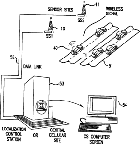
2s Fig. 5 shows an implementation of the present invention applied as a way to
monitor traffic flow using an existing cellular telephone network as the
wireless
communications system. The objective is to use a mobile transceiver 40 as a
probe
to determine the traffic flow along the highway 51. The representative
cellular
telephone 40 emits radio frequency signals that the receiver 32 at the sensor
-18-
SUBSTITUTE SHEET (RULE 26)
CA 02316170 2000-06-22
WO 98129758 PCTIUS97123864
stations 10 and 11 intercept. Preferably, the information pertaining to the
timing of
signal capture and other observed signal characteristics is then transmitted
to a
contra! station or traffic management center 53 -- preference should be given
to
transmitting timing and other characteristic information rather than the
received
s signal or other such basic data to minimize the amount of information that
is being
transmitted. The TDOA and correlated information is processed and can then be
displayed on a computer monitor 54 together with other useful information
derived
therefrom such as the rate of travel of the vehlcie on the highway 51.
The principles, preferred embodiments and modes of operation of the
io present invention have been set forth in the foregoing specification. The
embodiment disclosed herein should be interpreted as illustrating the present
invention and not as restricting it. The foregoing disclosure is not intended
to limit
the range of equivalent structure available to a person of ordinary skill in
the art in
any way, but rather to expand the range of equivalent structures in ways not
1s previously envisioned. Numerous variations and changes can be made to the
foregoing illustrative embodiments without departing from the scope and spirit
of the
present invention as set forth in the appended claims.
-19-
SUBSTITUTE SHEET (RULE 26)