Note: Descriptions are shown in the official language in which they were submitted.
' CA 02320393 2000-09-21
METHOD AND APPARATUS FOR CONTROLLING OF CONING IN
HYDROCARBON RECOVERY
The present invention relates to a method for recovering hydrocarbons
from a subterranean reservoir and monitoring the oil/water or gas/water
interface
to avoid the breakthrough of water into a producing well. A pilot borehole is
drilled from the main producing borehole and by using a combination of seismic
sources and/or receivers in the pilot hole, the interface between two fluid
phases
can be monitored in real time.
A specific problem frequently encountered during the recovery of liquid
hydrocarbons from a producing zone of a subterranean reservoir having an
overlying gas cap is a phenomenon termed "gas coning". This phenomenon
occurs when there is fluid communication between the producing zone and the
gas cap across vertical flowpaths. The producing wellbore is provided with
flow
control devices that are maintained in a closed position within the gas and
are
open in the oil. Under sufficient drawdown pressure, the high mobility gas cap
gas is drawn down from the gas cap through the vertical flowpaths into the
producing zone where it commingles with the lower mobility liquid
hydrocarbons residing therein.
Once in the producing zone, the gas cap gas tends to inhibit the flow of
liquid hydrocarbons into the wellbore by preferentially flowing through the
producing zone and entering the wellbore to the exclusion of the liquid
2 o hydrocarbons. Accordingly, gas coning is characterized by a significant
increase
1
CA 02320393 2000-09-21
in the gas/oil ratio of the produced fluids and an attendant significant
decrease in
the liquid hydrocarbon recovery rate from the production wellbore.
A similar problem occurs even in the absence of a gas cap when the oil is
in top of water in a reservoir rock. The flow control devices in this
situation are
arranged to produce from the upper portion of the reservoir and to avoid the
production of water. A water cone develops in the vicinity of the producing
well
with the narrow portion of the cone being at the top, in contrast to the case
of gas
coning where the narrow portion of the cone is at the bottom.
A similar problem occurs in thermal secondary recovery operations.
1 o Thermal secondary recovery operations are routinely employed to recover
heavy
hydrocarbons, e.g. heavy oil, from subterranean reservoirs (e.g. oil sands).
Due
to its high viscosity, the heavy oil must be heated in place to reduce its
viscosity
so it will flow from the reservoir. Probably the most common of such thermal
recovery operations involves "steam stimulation" wherein the heavy oil is
heated
15 in place by steam which is injected into the reservoir. A steam stimulation
or
steamflood process can be carned out by either (a) injecting the steam into an
injection well and then producing the hydrocarbons from a separate well or (b)
injecting the steam and then producing the fluids through the same well. This
type of steamflood operation results in a steam cone at the top of the heavy
oil.
2 o It is not uncommon for the same liquid hydrocarbon reservoir to be in
contact with a bottom water zone as well as a gas cap. Consequently, quite
often
a liquid hydrocarbon reservoir will be sandwiched between a gas cap above and
a water zone below with both the gas and water capable of playing beneficial
2
CA 02320393 2000-09-21
roles. For example, the expansion of the gas cap can be exploited to provide
driving force for pushing the liquid hydrocarbons out of the underground
reservoir. Similarly, if the water zone is being energized by an underground
aquifer, then the energy of the aquifer and the density difference between
water
and hydrocarbon can be exploited to move liquid hydrocarbons out of the
formation.
United States Patent No. 5,511,616 issued to Bert discloses a method
using an "inverted" production well for recovering hydrocarbons in a steam
injection process from a subterranean reservoir wherein the production
wellbore
1 o has a substantially vertical, non-inverted portion with angle building to
near 90°;
an integral, substantially horizontal portion which extends into said
reservoir;
and an integral, upwardly curving tail portion which terminates near the top
of
the reservoir. A string of production tubing which may include a downhole pump
is positioned within the non-inverted portion of wellbore. The inverted well
15 increases the production interval within the reservoir and reduces bottom-
water
coning.
United States Patent No. 5,322,125 issued to Sydansk discloses the use of
a foamed gel containing a crosslinkable polymer, a crosslinking agent, an
aqueous solvent, a surfactant, and a gas injected through the production
wellbore
2 o into gas-permeable matrix between the gas cap and wellbore, thereby
effectively
blocking or reducing the downward flow of gas from the gas cap to the
production wellbore and enabling the more desirable liquid hydrocarbons to
enter the wellbore for production to the surface.
CA 02320393 2000-09-21
United States Patent No. 5,421,410 issued to Irani discloses a method
wherein a polymer or a surfactant together with a cosolvent is introduced into
a
gaseous stream, e.g. carbon dioxide, in such ratio as to make the mixture just
homogeneous when injected through the appropriate perforations into the zones
above and below the oil bearing strata. The mixture is subject to
destabilization
thereafter, either through some exiting feature of the reservoir such as
temperature or the presence of water, or through some externally implemented
event, such as a sudden lowering of the pressure in the vicinity of the well
bore.
This causes the polymer or surfactant to come out of solution and aid in
plugging
1 o the zones through which vertical movement of gas and water, i.e. coning,
had
been taking place.
The prior art methods require somewhat complicated technologies. In
addition, the control of the coning is on an ad hoc basis with little regard
to
maintaining a high rate of production. There has been discussion in the
literature
1 s suggesting that maximum production over time is attained by a process in
which
the well is produced rapidly until just before the cone breaks through to the
producing levels in the wellbore and then slowing the rate of recovery until
the
cone subsides. This "on-off' method of flow control is ideally suited for
typical
lift and flow control devices used in conventional production technology.
2 o However, it requires the ability to monitor the level of the fluid-fluid
interface
defining the cone.
The typical lateral dimensions of the cone may be a few hundred meters
or less, and the typical reservoir formations may be a few meters or less in
4
' CA 02320393 2000-09-21
thickness. Conventional wireline methods are not suitable for detection of
coning. Sonic wireline surveys do not "see" any significant distance into the
formation, so that by the time a cone is detected, it may be too late. In
addition,
wireline surveys require that the production be shut down: this is an added
expense over and above the cost of the survey itself. The use of steel casing
in a
typical production environment rules out the use of electromagnetic induction
methods to see away from the borehole. Surface seismic surveys, while they can
provide information in real time and do not require a shutdown of the well, do
not provide the necessary lateral and vertical resolution. The vertical
resolution
of surface seismic methods for a reservoir at a typical reservoir depth of
4km. to
6 km. is of the order of a few meters or tens of meters and will not be able
to
easily resolve the fluid-fluid interface. The lateral resolution of surface
seismic
methods is of the order of tens or hundreds of meters: this makes it difficult
to
resolve the coning. In addition, surface seismic data is expensive to acquire.
1 s It is desirable to have a method of monitoring the location of interfaces
between two different fluids in a producing reservoir so as to be able to
control
production devices in the borehole and limit the production to the desirable
fluid.
Such a method should preferably provide information in close to real time and
also have a high resolution, so that optimum production rates can be
maintained
2 o without coning. The present invention satisfies this need.
The present invention provides a method for emplacing instruments in
micro boreholes extending from a production borehole in proximity to a
hydrocarbon reservoir from which oil or gas is being produced and using them
to
5
CA 02320393 2000-09-21
detect the location of the hydrocarbon/water interface near the production
borehole as well as changes in its location. In one method, multiple seismic
sources and receivers are permanently deployed in micro boreholes extending
laterally from the production well to either side of it above or below
reservoir to
be produced. Electrical signals produced by the conventional receivers which
may be hydrophones, geophones or accelerometers, in response to elastic waves
generated by one of the sources when it is activated are transmitted to the
surface
through the production well, recorded on a conventional seismic instrument
including an analog-to-digital converter and processed by conventional as well
1 o as novel geophysical digital processing methods to detect arrivals
reflected from
both stationary rock interfaces in the vicinity of the production borehole and
also
from the hydrocarbon/water fluid contact within the reservoir being produced
which moves as production proceeds. By comparing records obtained from the
same set of sources and receivers at different times during the production
life of
15 the production well, changes in the geometry of the hydrocarbon/water fluid
contact within the reservoir near the production borehole are detected and
used
to control the flow rate in the production well to avoid or at least delay
intrusion
of water from beneath the hydrocarbons in the reservoir into the production
borehole perforations which is known as water coning.
2 o In another embodiment of the present invention, the sources are located
in a separate lateral micro borehole from the receivers. In yet another
embodiment of the present invention, the seismic sources are located in the
production borehole and may be either permanently emplaced there between the
6
CA 02320393 2000-09-21
production well casing and the rock formation wall of the production well or
temporarily emplaced there on a wireline device deployed through a lubricator
inside the production well casing from time to time and withdrawn from the
production well when a complete record comprised of a recording from each
source point at each receiver location has been obtained at a given time or
during
a single deployment.
Another embodiment of the present invention involves the emplacement
of electrical sources and sensors in the micro boreholes or of electrical
sources in
the production borehole and electrical sensors in the micro boreholes
extending
to from it and detecting the proximity of the water in the reservoir to the
production
borehole perforations by a change in the measured rock conductivity or
resistivity.
For detailed understanding of the present invention, reference be made to
the following detailed description of the preferred embodiment, taken together
1 s with the accompanying drawings, in which like elements have been given
like
numerals, wherein:
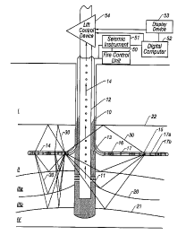
Fig. 1 shows a schematic illustration of a production borehole and lateral
micro
boreholes extending from it in which acoustic sources and receivers are
permanently deployed for conducting repetitive seismic according to an
2 o embodiment of the present invention.
Fig. 2 shows a schematic illustration of a production borehole lateral micro
boreholes extending from it in each of which either multiple seismic sources
or
7
CA 02320393 2000-09-21
multiple seismic receivers are permanently deployed for conducting repetitive
seismic surveys according to an embodiment of the present invention.
Fig. 2a shows a plan view of the schematic illustration depicted in Fig. 2
with
placement of different lateral micro boreholes at different azimuths.
Fig. 3 shows a schematic illustration of a production borehole which multiple
seismic sources are permanently emplaced and of one or more lateral micro
boreholes extending from it in which multiple seismic receivers are
permanently
emplaced for conducting repetitive seismic surveys according to an embodiment
of the present invention.
1 o Fig. 4 shows a schematic illustration of a production borehole in which
one or
more seismic sources may be temporarily deployed and of one or more lateral
micro boreholes extending from it in which multiple seismic receivers are
permanently emplaced for conducting repetitive seismic surveys according to an
embodiment of the present invention.
15 In general, the present invention provides methods of detecting the
location of a fluid interface within a hydrocarbon reservoir in the vicinity
of a
producing well with greater precision than it can otherwise be located by
employing downhole sources and detectors in lateral boreholes near the
producing reservoir extending from the producing well. It also provides
methods
2 o for using the image of such a fluid interface, the location of the
interface
determined from it or the change in location of the interface determined from
a
succession of such images or determinations to control the fluid flow in the
producing well.
8
CA 02320393 2000-09-21
Fig. 1 shows a schematic illustration of an example of the placement of
seismic sources and receivers in deep micro boreholes for conducting
subsurface
seismic surveys according to the present invention. For the purposes of
illustration and ease of understanding, the methods of the present invention
are
described by way of examples and thus, such examples shall not be construed as
limitations. In particular, while the example shown is for a water cone
underneath an oil-saturated zone, the same method can be used for monitoring
other types of fluid interfaces described above.
In this configuration, a production borehole 10 is drilled and completed
1 o in a particular hydrocarbon reservoir interval by conventional methods
based on
any pre-existing information about the subsurface. Such information typically
includes seismic surveys obtained with sources and receivers located at or
near
the surface of the earth or sea bottom and may also include information
obtained
from boreholes previously drilled in the vicinity of the production borehole,
for
15 example, with wireline logging devices, from full or sidewall core samples
or
from pressure or fluid flow tests. As an example, Fig. 1 shows separate rock
intervals I, II, III and IV of which interval III contains hydrocarbons in its
upper part (i.e. in interval IIIa) and water in its lower part (i.e. in
interval IIIb)
and is referred to hereinafter as the "production zone" or "reservoir."
2 o Production well 10 is completed in the upper part IIIa of reservoir III
which
contains hydrocarbons by means of perforations 11 connecting the production
borehole inside casing 12 to the reservoir through cement 13 which typically
holds the casing in place seals off the reservoir from other subsurface
formations
9
CA 02320393 2000-09-21
such as I and II. Reservoir fluids 14 may then be produced through this
production well by controlling the flow rate at the surface with some kind of
lift
control device 54 which typically may be a pump or automated control valve.
Multiple repeatable seismic sources 16 and multiple receivers 17 are
permanently deployed either on a single or on separate electrical or fiber
optic
cables in micro boreholes such as 14 and 15 drilled laterally from production
borehole 10 at a depth near but not in the production zone.
Though not necessary, it is preferable that individual receivers such as 17a
and 17b among multiple receivers 17 deployed in any particular lateral micro
1 o borehole such as 15 be equally spaced in a linear array with a separation
between
consecutive detectors small enough so that the difference in arrival time at
any
two consecutive receivers or detectors such as 17a and 17b for any reflected
signal of interest is less than one half the period of the highest useful
frequency
in the elastic wave impulse generated by any of the multiple sources 16. Each
i s individual receiver or detector such as 17a or 17b may also itself be
composed of
an array of several separate detecting elements extending along the axis of
micro borehole 15 and the electrical signals from each of these detecting
elements summed and recorded as a single signal corresponding to the position
of the center of this array. This geometry is a well-known method for
2 o suppressing high energy tube waves which may be generated by sources 16
and
can propagate along micro borehole 15 if it is left open (i.e. if it is only
fluid-filled) and which can interfere with detection of the desired reflection
signals. Alternatively, since both sources 16 and receivers 17 are permanently
CA 02320393 2000-09-21
deployed in micro boreholes such as 14 and 15, such micro boreholes may be
filled with cement or some other solid substance following deployment of
sources 16 and receivers 17 either before or during cementing of production
borehole casing 12.
While production borehole 10 must be large (i.e. usually six inches (6")
or more in inside diameter) to allow a substantial flow of reservoir fluids to
the
surface, lateral micro boreholes such as 14 and 15 need not be large since
they
only accommodate sources, detectors and the cables to which they are
connected.
Conventional high frequency geophones with dimensions of one inch (1 ") or
less are readily available and repeatable sources of similar dimension have
been
designed and are in use in commercially available slim-line wireline logging
tools. Conventional piezo-electric hydrophones of much smaller dimensions are
also presently commercially available as are optical hydrophones suitable for
use
with a fiber optic cable without transduction from a voltage to an optical
signal.
Seismic waves 30 generated by any of sources 16 with electrical
commands issued from fire control unit 50 at the surface of the earth which
simultaneously initiate recording by seismic recording instrument 51, are
reflected from boundaries between rock layers such as 21 and 22 as well as
from
hydrocarbon/water contact 20 within the reservoir, detected by receivers 17
and
2 o converted to electrical or optical signals which are transmitted up
through the
production borehole and recorded in seismic recording instrument 51 also
located at the surface of the earth near the production well head. For each
separate activation of any of sources 16, one record or seismic trace of
preset
11
CA 02320393 2000-09-21
duration is recorded at each of multiple receivers 17 for the pressure or for
each
component of particle motion to be sensed at that receiver location in seismic
recording instrument 51 and stored on magnetic tape or any other convenient
digital data storage medium.
Since the reflected waves 30 to be imaged in this invention need not
travel through more than several tens of meters of sedimentary rock, 16 may be
very low energy devices relative to those commonly employed seismic surveying
of deeply buried rocks such as those in the reservoir and thus need not cause
any
damage to production borehole 10 or the bond between production borehole
1 o casing 12 and the surrounding rocks in intervals I, II, III or IV provided
by
cement 13. Furthermore, seismic sources 16 generate either predominantly
compressional waves or predominantly shear waves of a specific polarization or
both.
Seismic receivers 16 may include devices such as geophones or
accelerometers capable of detecting the amplitude of a particular component of
particle motion or devices such as hydrophones which sense the magnitude of
the pressure resulting from the passage of any elastic wave.
Stored seismic traces may be read into digital computer 52 and processed
with a sequence of conventional seismic processing computer programs to
2 o enhance reflection signals 30, suppress noise and other types of coherent
signals
and form an image of hydrocarbon/water interface 20 as well as reflecting
interfaces between different rock intervals such as 21 and 22. If the
propagation
velocity in the various rock intervals is provided or estimated for the type
of
12
CA 02320393 2000-09-21
reflected elastic wave detected, such an image reveals the location of
hydrocarbon/water interface 20 near production borehole 10 with respect to the
other reflecting interfaces such as 21 and 22 as well as with respect to the
known
positions of sources 16 and receivers 17 at the time the seismic traces were
acquired. Alternatively, estimates of the appropriate propagation velocity in
the
rock intervals of interest can be derived from the acquired seismic data
themselves using known methods and the necessary image of the reflecting
horizons can be formed using this estimated velocity. Such methods for the
determination of propagation velocities would be known to those versed in the
1 o art. An image produced in this fashion may then be displayed using display
device 53 which may be a camera, plotter, cathode ray tube or any other
suitable
device. The location of hydrocarbon/water interface 20 may then be interpreted
either with software or by inspection of the displayed seismic image and
provided to lift control unit 54 to reduce or increase of hydrocarbon/water
15 interface 20 determined from the current seismic image may be compared with
that determined from a previous seismic image acquired with the same or nearly
the same sources and detectors and resulting from processing with the same or
substantially similar software and the differential movement in the position
of
hydrocarbon/water interface 20 may thus be determined from the time of
2 o acquisition of the previous seismic data to that of the current seismic
data and
this differential may be supplied to lift control unit 54 to change the flow
rate of
reservoir fluids. In case, the current image may be registered with respect to
the
previous image using reflection events from rock interfaces such as 21 and 22
13
CA 02320393 2000-09-21
either above or below the producing reservoir, the positions of which do not
change or change only slightly compared to that of hydrocarbon/water interface
during production.
A significant feature of this invention is the ability to perform the
imaging and determination of the location or change in location of
hydrocarbon/water interface 20 in the vicinity of production borehole 10 at
the
well site within no more than a few hours following completion of acquisition
of a single set of seismic traces at one time. This ability permits control of
the
flow rate to suppress the deleterious effects of water coning within shorter
time
1 o intervals than is possible with repeated surface seismic surveys.
In this embodiment a significant feature of this invention is the use of
high frequencies from several hundred up to several thousand Hertz to image
the
reflecting interfaces within and near the producing reservoir. Use of these
frequencies allows imaging of the depth of the target interfaces including
15 hydrocarbon/water interface 20 with much higher resolution than can be
achieved with lower frequency seismic surveys conducted from the surface of
the earth in which the highest useful frequency rarely exceeds one hundred
(100)
cycles per second. In addition, it provides a much smaller Fresnel zone at the
target reflectors and coupled with a much finer local spatial sampling with
2o source and receiver positions in the vicinity of production borehole 10,
provides
a more detailed indication of the lateral variation of hydrocarbon/water
interface
20 than can be achieved with the more coarse spatial sampling of source and
receiver locations common in surface seismic surveying. This higher resolution
14
CA 02320393 2000-09-21
imaging permits control of the fluid flow in response to much smaller changes
in
the location of hydrocarbon/water interface 20 than can be reliably detected
on
repeated surface seismic surveys.
In addition, the use of high frequencies will likely permit acquisition of a
survey during production without requiring interference with or temporary
interruption of production of hydrocarbons from production borehole 10 since
seismic noise from surface facilities is highest at the lower frequencies in
common use for surface seismic surveying but decreases markedly at higher
frequencies particularly for detectors separated from these large multiple
1o potential noise sources by a thick interval of absorbing material such as
rock
intervals I and II since the absorption of seismic energy increases with
increasing frequency in these materials.
Fig. 2 shows a schematic illustration of another example of the placement
of seismic sources and receivers in deep micro boreholes for conducting
15 subsurface seismic surveys according to a second method of one embodiment
of
the invention. In this configuration, lateral micro boreholes 114,115 and 118
are
drilled from production borehole 110 as described above in reference to Fig. 1
and seismic sources as described above in reference to Fig. 1 are permanently
emplaced in one or more separate micro boreholes such as 118. Micro borehole
20 114 and 115 which contain these repeatable seismic sources may be drilled
at
different azimuths from micro borehole 118 which contains permanently
emplaced seismic detectors as depicted in the schematic plan view illustration
shown in Fig. 2a. Seismic traces including reflection signals corresponding to
CA 02320393 2000-09-21
raypaths 130 and 131 are then recorded, processed and used to image reflecting
interfaces near and within the producing zone in the manner described above in
reference to Fig. 1. These images may then be used to control the fluid flow
in
production borehole 110 in the manner described above in reference to Fig. 1.
A
special benefit of this configuration is that high energy tube waves which may
be
generated by the seismic sources in micro boreholes 114 and 115 and which may
propagate along those boreholes are not present and do not propagate in micro
borehole 118 and therefore do not interfere with detection and imaging of the
desired reflection events corresponding to raypaths 130 and 131 observed on
the
1 o receivers in micro borehole 118.
Fig. 3 shows a schematic illustration of yet another example of the
placement of seismic sources and receivers in deep micro boreholes for
conducting subsurface seismic surveys according to a third method of one
embodiment of the invention. In this configuration, seismic sources are
i s permanently emplaced in the annulus of production borehole 210 between
casing
212 and the rock formations forming the walls of production borehole 210.
Seismic receivers are permanently emplaced in one or more separate micro
boreholes such as 218. Seismic traces including reflection signals
corresponding
to raypaths 230 are then recorded, processed and used to image described above
2 o in reference to Fig. 1. In this configuration, tube waves generated by
seismic
sources 216 in production borehole 210 are not well coupled into and thus do
not
propagate in lateral micro boreholes such as 218 and therefore do not
interfere
16
CA 02320393 2000-09-21
with detection and imaging of the desired reflection events corresponding to
raypaths 230 observed on the receivers in micro borehole 218.
Fig. 4 shows a schematic illustration of still another example of the
placement of seismic sources and receivers in deep micro boreholes for
conducting subsurface seismic surveys according to another embodiment of the
invention. In this configuration, hydrocarbon production from production
borehole 310 is temporarily halted while repeatable seismic sources 316 are
deployed on a wireline through a lubricator inside the casing in production
borehole 310. Seismic receivers are permanently emplaced in one or more
to separate micro boreholes such as 318. Seismic traces including reflection
signals
corresponding to raypaths 330 are then recorded, processed and used to image
reflecting interfaces near and within the producing zone in the manner
described
above in reference to Fig. 1.
Following excitation of seismic sources 316 at one position in production
15 borehole 310 and recording of seismic traces containing reflection events
corresponding to raypaths 330 on receivers 317, sources 316 may be moved up
or down in production borehole 310 and a new set of seismic data recorded in a
similar fashion. When seismic data have been collected from the desired number
of source locations within production borehole 310 during one deployment, the
2 o seismic sources are withdrawn from production borehole 310 and hydrocarbon
production is resumed. While in this configuration, production must be
interrupted while sources 316 are deployed and seismic survey data are
recorded,
17
CA 02320393 2000-09-21
the permanent deployment of expensive seismic sources in a hostile environment
is avoided.
In all of the embodiments discussed above, the position of the fluid
interface may be determined with respect to the surface of the earth or with
reference to a rock interface, such as 22 in Fig. 1, or the boundary between
rock
formations such as II and III ( where III comprises IIIa and IIIb).
In another embodiment of the present invention, instead of using
specially drilled micro boreholes, the sensors are placed in existing
wellbores
that are part of a multilateral wellbore. The geometry of the data acquisition
1 o geometry for monitoring of interfaces between two fluids is similar to
that
discussed above with reference with to Figs. 1 - 4 and this particular
embodiment of the invention is not discussed further. In yet another
embodiment of the invention shown in Fig. 5, the survey borehole is located
underneath the producing zone. Shown is a portion of a production borehole 410
with a casing 412 having perforations 411 for producing hydrocarbons from a
formation II that includes oil in the region IIa and water in the region IIb.
A
plurality of survey wellbores 415 that is beneath the producing interval are
used
to monitor the position of the interface 420 between hydrocarbons and water.
The survey wellbores have seismic sources 416 and seismic receivers 417. An
2 o exemplary raypath 430 of seismic energy from a transmitter to a receiver
that is
reflected from the fluid-fluid interface 420 is shown. The traveltime of this
raypath is indicative of the position of the interface 420 and is used to
monitor
18
CA 02320393 2000-09-21
the position of the interface in a manner similar to that discussed above with
reference to Figs. 1 - 4.
Those versed in the art would recognize that instead of seismic sources,
any other source-receiver type that is capable of detecting changes in the a
s formation within a few tens of meters of the survey holes could also be
used.
For example, wireline applications, induction logging sensors have been used
to
determine the conductivity of formations in the vicinity of a borehole.
Alternatively, ground penetrating radar could also be used to map the location
of
the fluid interface. These variations of the present invention are intended to
be
1 o within the scope of the claimed invention.
Another embodiment of the invention for monitoring the position of the
interface is shown in Fig. 6. A production borehole 510 produces hydrocarbons
from perforations 511 in a casing 512. The producing zone II comprises an oil
zone IIa and a water zone IIb. Transmitters 516 and receivers 517 are deployed
15 at the bottom of the producing interval. During the course of production,
the
position of the fluid interface 520 will change. This causes changes in the
sonic
velocity of the formation adjacent to the borehole that may be detected by
using
seismic transmitters and receivers. When electromagnetic transmitters and
receivers are used, the changing position of the interface changes the
electrical
2o conductivity of the formation adjacent to the borehole. These changes in
the
electrical properties of the formation may be detected by electromagnetic
transmitters and receivers mounted on an electrically non-conducting portion
of
the casing (not shown). When producing liquid hydrocarbons from a reservoir
19
CA 02320393 2000-09-21
having a gas cap, as noted above, the gas cone is inverted. In such a case,
the
sensors are deployed in the producing borehole above the perforated zone.
The arrangement of sensors illustrated in Fig. 6 may also be
implemented using other sensors, such as pressure sensors or gravity sensors.
When pressure sensors are deployed below the perforated zone, particularly
when the interface 520 separates a gas layer from an oil or water layer. A
change in the level of the interface will produce a change in the pressure
measured in the sensors below the interface due to the difference in density
between the fluids on opposite sides of the interface 520. Similarly, a change
in
to the level of the interface may also be detected by gravity sensors due to
differences in the fluid densities.
While the foregoing disclosure is directed to the preferred embodiments
of the invention, various modifications will be apparent to those skilled in
the
art. It is intended that all variations within the scope and spirit of the
appended
15 claims be embraced by the foregoing disclosure.