Note: Descriptions are shown in the official language in which they were submitted.
CA 02329673 2000-12-27
PATENT
EQUI-PRESSURE GEOSTEERING
BACKGROUND OF THE INVENTION
Field of the Invention
This invention relates generally to drilling of lateral wells into an oil rim
accumulation or
reservoir, and more particularly to the identification of the optimum vertical
position for drilling
such wells.
Description of the Related Art
Thin oil rim accumulations positioned between gas above and water below are
difficult
reservoirs to produce due to the tendency of water and gas to break through.
Production of such
accumulations from horizontal wells improves the ultimate recovery because the
resulting
increase in well productivity reduces the drawdown, and thereby reduces the
coning of unwanted
gas and water.
Known reservoir simulations can be used to estimate the optimum vertical
position of a
horizontal drainhole above the water contact and below the gas contact.
Drilling a lateral well at
this optimum drainhole position is difficult because geometric positioning
during directional
1 S drilling is achieved with imperfect surveying instruments.
SPE Paper No. 50072 entitled "Geosteering Horizontal Wells in a Thin Oil
Column,"
describes a method of horizontal drainhole positioning above the oil-water
contact layer using
resistivity determination. The resistivity directly above the oil-water
contact zone will increase
as the water saturation decreases to the irreducible value. This will occur
over a transition zone.
The shape and height of this transition zone is characterized by a capillary
pressure curve, which
is a function of porosity and lithology. An empirical algorithm may be
developed from offset-
near-vertical well logs that relates the resistivity response to height above
the oil-water contact
for a range of porosities and clay contents.
There are several problems with this approach. For example, the resistivity
value at a
fixed distance above the oil-water contact is not unique. A range of such
resistivity values exists
depending on the formation porosity and lithology. Thus, in order to apply
this technique,
multiple formation measurements are required.
CA 02329673 2004-04-08
79350-6
Another problem results from the fact that
resistivity measurements are typically focussed
perpendicular to the tool axis. Focussed resistivity
measurements recorded in a near-vertical well will be
dominated by the bed parallel resistivity, while focussed
resistivity measurements taken in a near-horizontal well
will be a combination of bed parallel and bed perpendicular
resistivity. Thus, if resistivity anisotropy is present, it
must be accounted for to apply an algorithm derived from
vertical wells.
To address these shortcomings, it is a principal
object of the present invention to provide formation
pressure-versus-depth data for a subsurface formation that
is useful for predicting the presence and depth of an oil
reservoir. The formation pressure and gradient is
established from offset near vertical wells, and used to
relate formation pressure to absolute depth. This pressure
gradient has been used to determine the vertical position of
a completed well whose wellbore pressure is at equilibrium
with the formation pressure by relating the wellbore
pressure measured with a wireline production logging tool to
the vertical height.
SUMMARY OF THE INVENTION
According to the invention there is provided a
method for indicating a desirable vertical depth for
drilling a horizontal well within a reservoir, comprising:
deploying a plurality of data sensors from a downhole tool
positioned in a wellbore, the data sensors lodged at
discrete depths into a subsurface formation penetrated by
the wellbore; gathering formation pressure data for the
discrete depths using the data sensors; and determining the
2
CA 02329673 2004-04-08
79350-6
vertical depth within a reservoir using the gathered
formation pressure data.
The downhole tool may be part of a drill string or
part of a wireline sonde. The receivers may be disposed
within the downhole tool.
The depth within the reservoir may be determined
by identifying from the gathered formation pressure data at
least one depth whose corresponding formation pressure is
suggestive of a reservoir. Once such a depth is identified,
the wellbore itself or a lateral drainhole depending from
the wellbore may be steered into the reservoir by
maintaining the trajectory of the wellbore or drainhole at a
substantially constant distance from a fluid contact within
the reservoir.
In a preferred embodiment, the vertical depth
within the reservoir is determined by
2a
CA 02329673 2000-12-27
PATENT
comparing the gathered formation pressure data with a pre-determined formation
pressure
gradient. The pre-determined formation pressure gradient is established from
vertical or near
vertical offset wells using wireline formation pressure measurements, or from
a near vertical
section of the wellbore using Logging-While-Drilling ("LWD") formation
pressure
measurements.
BRIEF DESCRIPTION OF THE DRAWINGS
So that the manner in which the present invention attains the above recited
features,
advantages, and objects can be understood in detail, a more particular
description of the
invention is provided by reference to the preferred embodiments) thereof which
are illustrated in
the accompanying drawings.
It is to be noted however, that the appended drawings illustrate only typical
embodiments) of this invention and are therefore not to be considered limiting
of its scope, for
the invention may admit to other equally effective embodiments.
In the drawings:
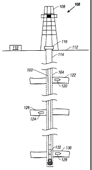
Figure 1 is a schematic representation, partially in section, of a drilling
rig supporting a
drill string within a wellbore made in the earth by the drill string, and a
plurality of remote
sensing units that have been deployed from the wellbore into various
formations of interest;
Figure 2 is a diagram of a drill collar positioned in a wellbore following
deployment from
the drill collar of a remote sensing unit into a formation of interest;
Figure 3 illustrates a portion of the drill collar of Fig. 2, including a
downhole
communication unit and a hydraulically energized system for forcibly inserting
a remote sensing
unit from the borehole into a selected subsurface formation;
Figure 4 is an electronic block diagram schematically representing the
downhole
communication unit of the drill collar of Fig. 3 for communicating with a
remote sensing unit or
units;
Figure 5 is an electronic block diagram schematically representing a remote
sensing unit
for sensing one or more formation data parameters such as pressure,
temperature and rock
permeability, placing the data in memory, and, as instructed, transmitting the
stored data to a
downhole communication unit;
3
CA 02329673 2000-12-27
PATENT
Figure 6 is an electronic block diagram schematically illustrating the
receiver coil circuit
of Fig. 5 in greater detail;
Figure 7 is a transmission timing diagram showing pulse duration modulation
used in
communications between a downhole communication unit and a remote sensing
unit; and
Figure 8 is a schematic representation of a wellbore with a plot of pressure
versus depth,
in accordance with the present invention, superimposed thereon.
DETAILED DESCRIPTION OF THE INVENTION
Figure 1 illustrates drilling rig 106 supporting drill string 103 within
wellbore 104 made
in the earth by drill string 103 in one of the many known drilling techniques,
including rotary
drilling, directional drilling, or a combination of the two. A plurality of
remote sensing units
120, 124 and 128 are shown positioned within various formations of interest,
122, 126 and 130,
respectively, as a result of having been deployed from a tool positioned in
wellbore 104.
Drilling for the discovery and production of oil and gas may be onshore (as
illustrated) or
may be off shore or otherwise upon water. When offshore drilling is performed,
a platform or
floating structure is used to service the drilling rig. The present invention
applies to both onshore
and off shore operations. For simplicity in description, onshore installations
will be described.
When drilling operations commence, casing 114 is set and attached to earth 112
in
cementing operations. Blow-out-preventer stack 116 is mounted onto casing 114
and serves as a
safety device to prevent formation pressure from overcoming the pressure
exerted upon the
formation by a drilling mud column. Within wellbore 104 below casing 114 is an
uncased
portion of the wellbore that has been drilled in earth 112 in the drilling
operations. This uncased
portion of the wellbore or borehole is often referred to as the "open-hole."
According to the present invention, remote sensing units are deployed into
formations of
interest from wellbore 104. For example, remote sensing unit 120 is deployed
into subsurface
formation 122, remote sensing unit 124 is deployed into subsurface formation
126, and remote
sensing unit 128 is deployed into subsurface formation 130. Remote sensing
units 120, 124 and
128 measure properties of their respective subsurface formations. These
properties include, for
example, formation pressure, formation temperature, formation porosity,
formation permeability
and formation bulk resistivity, among other properties. This information
enables reservoir
4
CA 02329673 2000-12-27
PATENT
engineers and geologists to characterize and quantify the characteristics and
properties of
subsurface formations 122, 126 and 130. Upon receipt, the formation data
regarding the
subsurface formation may be employed in computer models and other calculations
to adjust
production levels and to determine where additional wells should be drilled.
As contrasted to other measurements that may be made upon the formation using
measurement while drilling (MWD) tools, mud logging, seismic measurements,
well logging,
formation samples, surface pressure and temperature measurements and other
prior techniques,
remote sensing units 120, 124 and 128 remain in the subsurface formations.
Remote sensing
units 120, 124 and 128 therefore may be used to continually collect formation
information not
only during drilling but also after completion of the well and during
production. Because the
information collected is current and accurately reflects formation conditions,
it may be used to
better develop and deplete the reservoir in which the remote sensing units are
deployed.
Furthermore, such information may be used for steering a horizontal component
of the wellbore
into a thin oil rim accumulation or reservoir in accordance with the present
invention, as will be
described below.
As indicated in Figure l, remote sensing units 120, 124 and 128 are preferably
set during
open-hole operations. The remote sensing units may be deployed from either a
drill string tool
that forms part of the collars of the drill string, or from an open-hole
logging tool.
Figure 2 illustrates deployment of remote sensing unit 124 from drill collar
132 of drill
string 103 (also shown in Figure 1). Figure 3 shows that drill collar 132 is
provided with an
instrumentation section 312 and a power cartridge 314 incorporating the
transmitter/receiver
circuitry of Figure 4. Instrumentation section 312 includes pressure gauge 316
having pressure
transducer 318 exposed to wellbore pressure via drill collar passage 320.
Pressure gauge 316
senses wellbore pressure at a depth of a selected subsurface formation and is
used to verify
pressure calibration of the remote sensing units. Electronic signals
representing wellbore
pressure are transmitted via pressure gauge 316 to the circuitry of power
cartridge 314 which, in
turn, accomplishes pressure calibration of the remote sensing unit being
deployed at that
particular well bore depth. Drill collar 132 is also provided with one or more
remote sensing unit
receptacles 222, each containing a remote sensing unit, such as remote sensing
unit 124, for
positioning within a selected subsurface formation which is penetrated by
wellbore 104.
5
CA 02329673 2000-12-27
PATENT
The remote sensing units are encapsulated "intelligent" remote sensing units
which are
moved from drill collar 132 to a position in the formation surrounding
wellbore 104 for sensing
formation parameters such as pressure, temperature, rock permeability,
porosity, conductivity and
dielectric constant, among others. The remote sensing units include sensors
appropriately
encapsulated in a remote sensing unit housing, or shell, of sufficient
structural integrity to
withstand damage during movement from the drill collar into laterally embedded
relation with
the subsurface formation surrounding the well bore. A shell consisting at
least partially of a
tungsten alloy is believed to be suitable for this purpose.
Those skilled in the art will appreciate that the lateral deployment or
imbedding
movement of the remote sensing units) need not be perpendicular to wellbore
104, but may be
accomplished through numerous angles of attack into the desired formation of
interest.
Deployment can be achieved by utilizing one or a combination of the following:
(1) drilling into
the wellbore wall and placing the remote sensing unit into the formation; (2)
punching/pressing
the remote sensing unit into the formation with a hydraulic press or
mechanical penetration
assembly; or (3) shooting the encapsulated remote sensing units into the
formation by utilizing
propellant charges.
As shown in the embodiment of Figure 3, a hydraulically energized ram 330 is
employed
to deploy the remote sensing unit 124 and to cause its penetration into the
subsurface formation
to a sufficient position outwardly from the borehole that it senses selected
parameters of the
formation. For deployment of remote sensing unit 124, the drill collar is
provided with an
internal cylindrical bore 326 within which is positioned a piston element 328
having a ram 330
that is disposed in driving relation with the encapsulated remote intelligent
remote sensing unit
124. The piston 328 is exposed to hydraulic pressure that is communicated to
piston chamber
332 from a hydraulic system 334 via a hydraulic supply passage 336. The
hydraulic system is
selectively activated by the power cartridge 314 so that the remote sensing
unit can be calibrated
with respect to ambient borehole pressure at formation depth, as described
above, and can then
be moved from the receptacle 222 into the formation beyond the borehole wall
so that the
formation pressure parameters will be free from borehole effects.
Referring now to Figure 4, the power cartridge 314 of the drill collar 132
incorporates at
least one transmitter/receiver coil 438 having a transmitter power drive 440
in a form of a power
6
CA 02329673 2000-12-27
PATENT
amplifier having its frequency F determined by oscillator 442. The drill
collar instrumentation
section is also provided with a tuned receiver amplifier 443 that is set to
receive signals at a
frequency 2F which will be transmitted to the instrumentation section of the
drill collar by the
remote sensing units) as will be explained herein below.
With reference to Figure 5, the electronic circuitry of a remote sensing unit
is shown by a
block diagram and includes at least one transmitter/receiver coil 546, such as
an RF antenna, with
the receiver thereof providing an output 550 from a detector 548 to a
controller circuit 552. The
controller circuit is provided with one of its controlling outputs 554 being
fed to a pressure gauge
556 so that gauge output signals will be conducted to an analog-to-digital
converter
("ADC/Memory") 558, which receives signals from the pressure gauge via a
conductor 562 and
also receives controls signals from the controller circuit 552 via a conductor
564.
A battery 566 also is provided within the remote sensing unit circuitry and is
coupled
with the various circuitry components of the remote sensing unit by power
conductor 570. While
the described embodiment of Figure 5 illustrates only a battery as a power
supply, other
embodiments of the invention include circuitry for receiving and converting RF
power to DC
power to charge a charge storage device such as a capacitor.
A memory output 574 of the ADC/Memory circuit 558 is fed to a receiver coil
control
circuit 576. The receiver coil control circuit 576 functions as a driver
circuit via conductor 578
for the transmitter/receiver coil 546 to transmit data to instrumentation
section 312 of drill collar
132.
Refernng now to Figure 6, a low threshold diode 680 is connected across the
receiver coil
control circuit 676. Under normal conditions, and especially in the dormant or
"sleep" mode, the
electronic switch 682 is open, minimizing power consumption. When the receiver
coil control
circuit 576 is activated by the drill collar's transmitted electromagnetic
field, a voltage and a
current is induced in the receiver coil control circuit. At this point,
however, the diode 680 will
allow the current the flow only in one direction. This non-linearity changes
the fundamental
frequency F of the induced current shown at 784 in Figure 7 into a current
having the
fundamental frequency 2F, in other words, twice the frequency of the
electromagnetic wave 784
as shown at 786.
7
CA 02329673 2000-12-27
PATENT
Throughout the complete transmission sequence, the transmitter/receiver coil
438, shown
in Figure 4, is also used as a receiver and is connected to a receiver
amplifier 443 which is tuned
at the 2F frequency. When the amplitude of the received signal is at a
maximum, a remote
sensing unit is located in close proximity for optimum transmission between
drill collar and the
remote sensing unit.
Assuming that remote sensing units are in place inside the formation to be
monitored, the
sequence in which the transmission and the acquisition electronics function in
conjunction with
drilling operations is as follows:
The drill collar with its acquisition sensors is positioned in close proximity
of the remote
sensing units) 124. An electromagnetic wave having a frequency F, as shown at
784 in Figure 7,
is transmitted from the drill collar transmitter/receiver coil 438 to "switch
on" the remote sensing
unit and to induce the remote sensing unit to send back an identifying coded
signal. The
electromagnetic wave initiates the remote sensing unit's electronics to go
into the acquisition and
transmission mode, and pressure data and other data representing selected
formation parameters,
as well as the remote sensing unit's identification codes, are obtained at the
remote sensing unit's
level. The presence of the remote sensing unit is detected by the reflected
wave scattered back
from the unit at a frequency of 2F as shown at 786 in the transmission timing
diagram of Figure
7. At the same time, pressure gauge data (pressure and temperature) and other
selected formation
parameters are acquired and the electronics of the remote sensing unit
converts the data into one
or more serial digital signals. This digital signal or signals, as the case
may be, is transmitted
from the remote sensing unit back to the drill collar via the
transmitter/receiver coil 746. This is
achieved by synchronizing and coding each individual bit of data into a
specific time sequence
during which the scattered frequency will be switched between F and 2F. Data
acquisition and
transmission is terminated after stable pressure and temperature readings have
been obtained and
successfully transmitted to the on-board circuitry of the drill collar 132.
Whenever the sequence above is initiated, the transmitter/receiver coil 438
located within
the instrumentation section of the drill collar is powered by the transmitter
power drive or
amplifier 440. And electromagnetic wave is transmitted from the drill collar
at a frequency F
determined by the oscillator 442, as indicated in the timing diagram of Figure
7 at 784. The
frequency F can be selected within the range 100 kHz up to 500 MHz. As soon as
the target
8
CA 02329673 2000-12-27
PATENT
comes within the zone of influence of the collar transmitter, the
transmitter/receiver coil 546
located within the remote sensing unit will radiate back an electromagnetic
wave at twice the
original frequency by means of the receiver coil control circuit 576 and the
transmitter/receiver
coil 546.
In contrast to present-day operations, the present invention makes pressure
data and other
formation parameters available while drilling, and, as such, allows well
drilling personnel to
make decisions concerning drilling mud weight and composition as well as other
parameters at a
much earlier time in the drilling process without necessitating the tripping
of the drill string for
the purpose of running a formation tester instrument. The present invention
requires very little
time to gather the formation data measurements. Once the remote sensing units
are deployed,
data can be obtained while drilling, a feature that is not possible according
to known well drilling
techniques.
Time dependent pressure monitoring of penetrated well bore formations can also
be
achieved. This feature is dependent of course on the communication link
between the
transmitter/receiver circuitry within the power cartridge of the drill collar
and any deployed
remote sensing units.
The remote sensing unit output can also be read with wireline logging tools
during
standard logging operations. This feature of the invention permits varying
data conditions of the
subsurface formation to be acquired by the electronics of logging tools in
addition to the real time
formation data that is now obtainable while drilling.
By positioning be intelligent remote sensing units 124 beyond the immediate
borehole
environment, at least in the initial data acquisition period there will be
very little borehole effects
on the noticeable pressure measurements that are taken. As extremely small
liquid movement is
necessary to obtain formation pressures with in-situ sensors, it will be
possible to measure
formation pressure in fluid bearing non-permeable formations. Those skilled in
the art will
appreciate that the present invention is equally adaptable for measurements of
several formation
parameters, such as permeability, conductivity, dielectric constant, rocks
strength, and others, and
is not limited to formation pressured measurement.
As indicated previously, deployment of a desired number of such remote sensing
units
occurs at various wellbore depths as determined by the desired level of
formation data. As long
9
CA 02329673 2000-12-27
PATENT
as the wellbore remains open, or uncased, the deployed remote sensing units
may communicate
directly with the drill collar, sonde, or wireline tool containing a data
receiver to transmit data
indicative of formation parameters to a memory module on the data receiver for
temporary
storage or directly to the surface via the data receiver.
The present invention utilizes the absolute formation pressure data available
from a
plurality of remote sensing units placed at discrete depths to steer and keep
the trajectory of a
well at a desirable depth. The pressure gradient across an oil rim in a
subsurface formation
creates a simple linear relationship between the pressure measurement and
vertical depth if the
oil-water contact is horizontal. The fluid contacts in unproduced reservoirs
are only tilted if
hydrodynamic forces exist. The presence of such forces can be identified by
comparing several
offset well formation pressure gradients.
The pressure-to-vertical depth relationship is easier to establish and is more
direct that a
resistivity-to-vertical depth relationship using a water saturation
computation. Each absolute
pressure measurement can be used to determine the depth, and therefore the
height above the oil-
water contact beneath a reservoir. This technique may be described as equi-
pressure geosteering.
The equi-pressure geosteering method utilizes a plurality of deployed remote
sensing
units, such as sensing units 802-816 depicted in Fig. 8. Formation pressure
data is gathered for
the discrete depths at which the sensing units are respectively deployed, and
a pressure-versus-
depth profile is determined using the gathered formation pressure data.
The formation pressure is gathered using receivers for receiving the formation
pressure
data transmitted by the data sensors. The receivers may be disposed within a
downhole tool, and
may be part of a drill string as is described above in the form of drill
collar 132 or may be part of
a wireline sonde.
The vertical depth within an oil reservoir may be determined from a single
formation
pressure measurement, preferably in combination with an established formation
pressure
gradient. This formation pressure gradient is established from vertical or
near vertical offset
wells using wireline formation pressure measurements, or from the near
vertical section of the
current hole using Logging-While-Drilling ("LWD") formation pressure
measurements. The
LWD measurements may be of the type described above using a plurality of
deployed remote
sensing units, or may be of the type otherwise known in the art of acquiring
Formation-Pressure-
CA 02329673 2000-12-27
PATENT
While-Drilling ("FPWD"). Once such a depth is identified, the primary wellbore
or a lateral
drainhole depending from the wellbore may be steered within the reservoir
parallel and at a
substantially constant offset depth from the fluid contacts by maintaining the
trajectory of the
wellbore or drainhole substantially at the identified depth.
Stated another way, the desired depth within an oil reservoir may be
identified by plotting
the pressure-versus-depth profile determined from sensing units 802-816, and
observing changes
in the slope of the data points. These slope changes are indicative of the gas-
oil contact above
the reservoir and the oil-water contact below the reservoir, and are
illustrated in the plot shown in
Fig. 8. Thus, the pressure data provides a guide for setting and maintaining
the drilling at a
desirable depth.
A formation pressure while drilling measurement which uses separate remote
sensors is
ideally suited for this application. The expected pressure at each deployment
depth is generally
known beforehand, so that each sensor can be equipped with a sensitive
pressure transducer or
gauge that covers a relatively narrow range such as, for example, a full scale
deflection of only
50 psi. Assuming the absolute accuracy of each pressure measurement to be
within +/- 1 psi, the
total depth will be determinable to within +/- 1.3 feet in an 0.8 gm/cc oil
column. The 2-sigma
TVD error of a typical MWD survey instrument will reach this level after a 760
foot departure
from a fixed reference such as a gas/oil contact. Any horizontal length
drilled beyond this point
could have an improved vertical positioning from formation pressure derived
depth.
This approach only controls the vertical position of the drainhole. Azimuthal
positioning
of the well can be achieved either geometrically or through geosteering using
LWD
measurements to avoid non-reservoir formations.
In view of the foregoing it is evident that the present invention is well
adapted to attain all
of the objects and features hereinabove set forth, together with other objects
and features which
are inherent in the apparatus disclosed herein.
As will be readily apparent to those skilled in the art, the present invention
may easily be
produced in other specific forms without departing from its spirit or
essential characteristics.
The present embodiment is, therefore, to be considered as merely illustrative
and not restrictive.
The scope of the invention is indicated by the claims that follow rather than
the foregoing
description, and all changes which come within the meaning and range of
equivalence of the
11
CA 02329673 2000-12-27
PATENT
claims are therefore intended to be embraced therein.
12