Note: Descriptions are shown in the official language in which they were submitted.
CA 02334585 2000-12-07
WO 99/64681 PCT/NL99/00346
1
DEVICE FOR DETERMINING THE CONTOUR OF A ROAD SURFACE
The invention relates to a device for determining a
desired contour of a ground surface, for instance a road
surface, relative to the actual contour of that ground
surface, at least comprising measuring means for generating
along a determined distance from a ground surface actual
values for the height and position of a number of points of
that ground surface relative to a determined reference
point.
Such a device for determining the contour of a road
surface is known for the purpose of applying a new top layer
of for instance asphalt or asphalt concrete, wherein use is
made of a so-called multi-foot ski. A multi-foot ski
comprises a number of flat plates or feet, two of which are
mounted pivotally in each case on an elongate first arm
which, using a second elongate arm, is in turn pivotally
coupled at a point in the middle to a following first arm on
which two feet are also pivotally mounted. Using a third
elongate arm the second elongate arm is pivotally coupled at
a point in the middle to a corresponding subsequent second
arm, wherein all arms extend in the same direction. During
asphalting operations a multi-foot ski is dragged by an
asphalt spreading machine alongside this machine over a
strip of road surface adjacent to the part of this road
surface which is to be asphalted. The height of the middle
of a first arm of the multi-foot ski relative to a measuring
point on the asphalt spreader is determined by the average
height of the respective feet under this first arm. The
height of the middle of a second arm of the multi-foot ski
relative to the measuring point on the asphalt spreader is
determined by the average height of the middles of the
respective first arms under this second arm. The height of
the middle of the third arm of the multi-foot ski relative
to the measuring point on the asphalt spreader is determined
by the average height of the middles of the respective
second arms under this third arm. Situated on the asphalt
CA 02334585 2000-12-07 E PO- D G 1
08. 05. 2000
2 41
spreader at the measuring point is a height sensor, for
instance an ultrasonic transmitter/receiver combination,
which measures the height of the middle of the third arm and
thereby the average height of all feet in the multi-foot
ski. In this way an average value progressing in lengthwise
direction of the road surface is obtained for the height of
this road surface, wherein abrupt transitions in height,
resulting for instance from damage to the road surface, are
averaged out. This average value is entered into a control
circuit for a finishing beam which is dragged along over a
newly laid asphalt layer in order to give this layer the
desired thickness, wherein the effect of discontinuities in
the underlying road surface is reduced by averaging.
US-A-4 065 856 discloses an optical system for a
reference datum in relation to which operations can be
carrried out in roadway workings. This optical system
comprises optical devices which define an optical triangle
whose plane inclines downwardly towards the plane of the
roadway. The inclination of the plane of the optical
triangle is adjustable so that a corner of the triangle is
set at the level of the roadway as determined by a reflected
image of the roadway surface. The optical system comprise a
light source, e.g. a laser, and a receiver, which both are
carried by a table which is pivotally mounted on a roadway
maintainance machine, in this case a conventional track
lifting and ballast tamping machine. The table is
mechanically coupled for vertical movement with a track
lifting device. The emitted light beam reflects on the
underground of a railway track and is swept over the
underground by pivoting the table, until the reflected beam
just falls in the middle of the detector. In this situation
the lifting device is at its desired height to perform its
function, after which the machine is moved forward and the
described operation is repeated.
According to this prior art, the reference point f or
levelling a railway track is situated on a fixed distance in
front of the machine. Modulations in the contour of the
ground surface are thus reduced by a factor corresponding
AMENDED SHEET
CA 02334585 2006-04-21
2A
with the ratio of distances from the pivoting point to
respectively the reference point and the point on the ground
surface to be corrected.
According to the prior art it is not possible however
to eliminate the effect of modulations in the ground
surface, making this device not applicable in combination
with e.g. an asphalt spreader, a grader or a scarifier.
DE-A-44 27 724 discloses a device for performing a
trigonometric measurement of an angle-dependent variable,
comprising a continuous laser, emitting its coherent light
on a rotating mirror. In the range of the pivoting laser
beam two detectors are provided: a reference detector and a
distance detector, the signals of which are to be compared
in a comparator, for calculating a rotation angle from the
time dif.ferences.
DE-A-196 24 751 discloses a device for performing a
transit time measurement with a continuous laser, emitting
its light on a rotating mirror. The rotating mirror projects
the laser beam on a position resolving detector for
generating a signal from which transit time information is
to be obtained.
The known contour-determining device with multi-foot
ski has a number of drawbacks. Due to the mechanical
suspension of the feet the measurement range of the
measuring device which can be realized in practice is
smaller than is desirable for a good insight into the
contour of a road surface. Transport and assembly of the
multi-foot ski are time-consuming, while during the
disassembly required in respect of transport components are
in practice quite often lost. Use of the multi-foot ski in a
contour-measuring device is limited to a ground with a solid
structure due to the required mechanical contact with a
ground, so that the multi-foot ski is for instance
unsuitable for measuring the contour of a sandy ground. In
an asphalt spreader the multi-foot ski must necessarily
always be placed just adjacently of the part of a road
surface for asphalting so that only an approximation of the
contour of the road surface for asphalting can be obtained.
CA 02334585 2006-04-21
2B
In practice the feet of the multi-foot ski are nevertheless
found during asphalting to come into contact with and to be
fouled with a freshly applied tacky layer, which may result
in poor functioning and in any case requires additional
maintenance.
The object of the invention is to provide a contour-
measuring device which does not have these drawbacks.
CA 02334585 2006-04-21
3
SUMMARY OF THE INVENTION
According to the present invention, there is provided a device for
determining a desired contour of a ground surface, for instance a road
surface,
relative to the actual contour of that ground surface, at least comprising
measuring means for generating along a determined distance from the ground
surface actual values for the height and position of a number of points of
that
ground surface relative to a determined reference point, said measuring means
comprising a laser light source which can be placed at a measuring point above
the ground surface and which is adapted to generate a laser beam moving over
said determined distance from the ground surface and sensor means for
detecting the laser beam reflected by the ground surface to the measuring
point,
characterized in that the measuring means further comprise:
time-measuring means for determining the transit time of said laser beam
between the laser light source and the sensor means, and
processing means for generating, from signals from the laser light source,
the sensor means and the time-measuring means, actual values for the height
and the position of a number of points of this ground surface relative to the
measuring point, and for calculating from these actual values desired values
for
height and position of a number of points on the desired contour of this
ground
surface, which processing means are adapted to replace an actual value for the
height of a point with a substitute value if this actual value exceeds a
predetermined threshold value.
Preferably, the laser light source generates for instance a pulsed laser
beam scanning a determined angular range which strikes the ground surface, is
reflected and detected by the sensor means, wherein the transit time is
directly
proportional to the distance between light source and point on the ground
surface. The position of the point on the ground surface can be precisely
determined relative to the laser light source (the measuring point) from the
angle
at which the laser beam was transmitted and the determined distance.
CA 02334585 2006-04-21
3a
With a contour-measuring device according to the
invention it is possible to measure the contour of a ground
surface in contact-free manner and to determine for each
point on this ground surface a desired height which is
determined by the actual height of that point and of a large
number of nearby points on that ground surface, wherein the
processing means correct for discontinuities in the values
for the actual height of these points.
It is possible with a measuring device according to the
invention to determine the desired contour on the basis of
the actual height of a very large number of points in close
CA 02334585 2000-12-07
WO 99/64681 PCT/NL99/00346
4
succession-over a relatively large range on the ground
surface, while the number of points for determining an
average height of a point using the known measuring device
with a multi-foot ski is limited to the number of feet under
this ski, wherein the total length of the ski moreover
defines the range of the measurement.
In a contour-measuring device according to the
invention the processing means are preferably adapted to
replace an actual value for the height of a point with a
substitute value if this actual value exceeds a
predetermined threshold value.
With this preferred embodiment it is possible to
determine the contour of a road surface for asphalting
within the width range of an asphalt spreader, since
incorrect information concerning the actual contour of the
road surface, which can for instance result from reflection
of the scanning laser beam on components of the asphalt
spreader, are recognized and eliminated.
In an advantageous embodiment the processing means are
adapted to separately calculate for each of the number of
points on a desired contour of the ground surface the values
for height and position of these points. The possibility of
calculating for each of a discrete number of points on a
desired contour the height relative to the corresponding
actual point makes it possible, otherwise than in contour
determination with a multi-foot ski, to make the desired
contour while taking into account the occurrence of a
variation over a short distance in the actual contour
relative to the average contour measured over a longer
distance. In particular it is possible to design a desired
convex contour portion above an actual concave contour
portion in a road surface. In a practical situation such a
concave contour portion results from settling of the ground
at that location. This settling of the ground can be taken
into account during asphalting by depositing the asphalt
layer in accordance with the designed convex contour,
whereafter the asphalt undergoes a so-called postcompaction
with the action of a roller thereover.
CA 02334585 2006-04-21
In yet another preferable embodiment the contour-measuring device
according to the invention comprises memory means for storing values for the
actual position of a number of predetermined points of a ground surface and
the
predetermined value for the desired height of these points, and the processing
means are adapted to calculate the value for a desired height of points
located
between these predetermined points compatible with this predetermined value
for the desired height of these points.
BRIEF DESCRIPTION OF THE DRAWING
The invention will be elucidated hereinafter on the
basis of embodiments and with reference to the drawings.
In the drawings:
Fig. 1 shows a greatly simplified perspective view of a
multi-foot ski according to the prior art,
Fig. 2 shows schematically in side view the multi-foot
ski of fig. 1 in combination with an asphalt spreader,
Fig. 3 shows the combination of fig. 2 in top view,
Fig. 4 shows schematically in perspective view an
example of a contour-measuring device according to the
invention for a first application in combination with
several parts of an asphalt spreader above a road surface
for asphalting,
Fig. 5 shows a greatiy simplified block diagram of the
device of fig. 4,
Fig. 6 shows a diagram of the progression of the laser
beams transmitted by the laser scanner of fig. 4 in
combination with the actual contour and a number of contours
determined using the measuring device, and
Fig. 7 shows schematically in side view an example of a
contour-measuring device according to the invention for a
second application in combination with several parts of an
asphalt spreader above a road surface for asphalting.
Corresponding components are designated in the figures
with the same reference numerals.
CA 02334585 2006-04-21
5a
Fig. 1 shows a multi-foot ski 1 with eight feet 2, two
of which are pivotally mounted in each case on a first arm
3. First arms 3 are mutually coupled for pivoting at a point
in the middle using second arms 4. The two outermost second
CA 02334585 2006-04-21
6
arms 4 are-mutually coupled for pivoting at a point in the
middle using a third arm (or wire connection) 5. Fixed to
the outermost second arms 4 are dragging arms 6, by means of
which multi-foot ski 1 can be dragged along over a ground.
If the height of the eight feet 2 in a chosen coordinate
system is given respectively by the values zl, z,, ..., zB,
it is then readily understood that the height of the middle
of the third arm 5, with the exception of one constant, is
given in first order of approximation by the average value
'/8(zl+z2+ ...+zb) of the heights of the individual feet 2. The
length of a multi-foot ski is limited in practical
situations to about 12 m.
Fig. 2 shows an application of multi-foot ski 1 of fig.
1 in determining the contour of a road surface 7 which is
being asphalted using a (schematically shown) asphalt
spreader 8, of which are shown a caterpillar track 9, a
finishing beam 10 fixed to a pivotable pulling arm 11, a
hydraulic cylinder 12 with piston rod 13 which is coupled to
pull rod 11 and a level meter 14 for measuring the height of
the middle of third arm 5 of multi-foot ski 1 dragged along
by asphalt spreader 8. In asphalt spreader 8 asphalt is
deposited over the whole width of the machine (represented
by arrow i5) just in front of finishing beam 10, whereby the
asphalt is distributed evenly over the underlying road
surface 7. In asphalting operations using the shown
combination the average height of feet 2 is determined using
level meter 14, for instance an ultrasonic tracer, by
determining the height of the middle of third arm 5 of
multi-foot ski 1. An output signal of level meter 14
corresponding to this latter height is fed to a control
circuit (not shown), where a change in the signal from the
level meter results in a control signal being transmitted to
the drive of hydraulic cylinder 12 in order to effect a
corresponding displacement of piston rod 13. As a
consequence the angle a between pull rod 11 and the
direction of movement x of spreading machine 8, and
therewith the height of finishing beam 10 relative to road
surface 7, is altered accordingly.
CA 02334585 2006-04-21
7
Fig. 3 shows the combination of fig. 2 in top view.
The above listed drawbacks of the prior art contour-
measuring device will be immediately apparent from fig. 1-3.
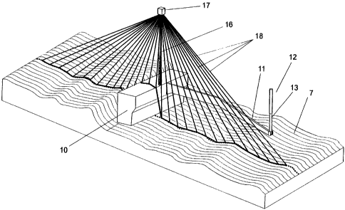
Fig. 4 is a greatly simplified view of the application
of a contour-measuring device according to the invention in
combination with several parts of an asphalt spreader above
a road surface for asphalting. Shown are a finishing beam 10
of an asphalt spreader (not further shown), which beam is
moved along above a road surface 7 for asphalting by a
pulling arm 11, a hydraulic cylinder 12 with piston rod 13
for the pulling arm 11 and a laser light source 17 which is
mounted on a post 16 within the width range of finishing
beam 10. Laser light source 17 is a laser measuring system
(for instance the commercially available system from the
producer Sick* type LMS200) which transmits a pulsed
infrared laser light beam 18 which, using a rotating mirror,
is deflected in steps of for instance 0.25 through an angle
of for instance 100 to 180 over road surface 7. A sensor
built into laser scanner 17 detects the part of a laser beam
18 reflected by road surface 7 and the distance between
scanner 17 and the relevant point (i) on the road surface
can be calculated from the transit time, from which distance
and the scanning angle the relative distance xi and the
relative height zi of a point i can be calculated. It can
readily be appreciated that a scanner 17 at a height of for
instance 2.5 m above road surface 7 at a scanning angle of
150 (75 in rearward and 75 in forward direction) covers a
distance of a length of about 18.6 m over the road surface.
Fig. 5 is a block diagram of the circuit for processing
the data collected by laser measuring system 17 of fig. 4.
The circuit successively comprises laser scanner 17, a
central processing unit (CPU) 19 and a control circuit 20
for driving hydraulic cylinder 12. Using laser measuring
system 17 actual values for the height z;' for a very large
number of points i on the road surface covered by the
scanning laser beam are determined as a function of the
actual location x;' in a coordinate system co-displacing with
scanner 17 and post 16. In CPU 19 values zi' are calculated
* trademarks
CA 02334585 2000-12-07
WO 99/64681 PCT/NL99/00346
8
from these actual values zia for a desired contour of a road
surface, wherein the calculated value for a point i' is
determined from the actual value of a chosen number (n+m) of
surrounding points. In the formula:
Zi' = zilc (Zia(Xia) ), wherein i'-m<i=<.i'+n (I)
Using the CPU it is possible with a contour measuring
device according to the invention to replace an actual value
for the height of a point with a substitute value if this
actual value exceeds a predetermined threshold value. A
threshold value is for instance exceeded if a laser beam
reflects from a component of the asphalt spreader, for
instance on finishing beam 10. Owing to the possibility of
recognizing incorrect measurement values, the laser scanner
can be applied without problem within the width range of an
asphalt spreader, whereby a more realistic picture can be
obtained of the contour of a road surface for asphalting
than is the case with the multi-foot ski.
Because the algorithm for calculating these values can
be chosen, otherwise than in contour determination using a
multi-foot ski, the desired contour is not however limited
to a contour wherein the calculated height of a point i' is
determined solely by the actual or substitute height of
surrounding points, but this calculated height can be
corrected, for instance in situations where the occurrence
of a structural subsidence in a road surface must be
compensated by arranging an overmeasure of asphalt. The
value for the calculated height is in that case increased by
a predetermined position-dependent term. In the formula:
Z1'C = Zi,'" (Zia (Xia) ) + OZi,a (X1,') , wherein i l-m<i<i'+n (II)
The desired calculated values zi' for the height of the
points i as a function of the position xi are fed to control
circuit 20, where a control signal is generated for driving
of cylinder 12.
Fig. 6 shows a diagram of the progression of the laser
beams 18 transmitted by laser scanner 17 of fig. 4 in
combination with the actual contour 21 ( ..... ), the contour
22 measured by laser scanner 17 (.-.-.-) and giving an image
of the actual contour of the road surface which is disturbed
CA 02334585 2000-12-07
WO 99/64681 PCT/NL99/00346
9
by the reflections from finishing beam 10, the actual
contour 23 corrected using CPU 19 (- --) and the desired
contour 24 which is calculated with CPU 19 ( ) and
which functions as input signal for control circuit 20.
Fig. 7 is a greatly simplified view of a second
application of a contour measuring device according to the
invention in combination with several parts of an asphalt
spreader above a road surface for asphalting. Shown in side
view are a finishing beam 10 of an asphalt spreader (not
further shown) moved along by a pulling arm 11 above a road
surface 7 for asphalting and a laser scanner 17 mounted on a
post 16. For the road surface the desired elevation AYi
relative to the actual height Y, is predetermined.in
reference points Xj, while the desired elevation of the road
surface located between two reference points is determined
by a smooth line 25 connecting the two reference points for
elevating. In the prior art this interpolation takes place
in practice by manual intervention in the control circuit
for a finishing beam. By entering the predetermined values
AY,(Xj) in the memory of CPU 19 and programming this latter
accordingly, the interpolation for the desired height of
points between successive reference points X,, X,+1 can be
supplied by the CPU. If the range of the laser scanner
covers the distance between two successive reference points
Xi, Xj+1, the actual height hj+l of a reference point relative
to the height of the preceding reference point hi can be
determined in each case, and the calculated values can be
fed in real-time to control circuit 20 for finishing beam 10
of an asphalt spreader, so that manual intervention in the
control of the finishing beam is unnecessary, so that
asphalt 26 is deposited in fully automated manner along the
desired contour 25.
It is pointed out that use of the invention is not
limited to the combination with an asphalt spreader, but
that the invented contour-determining device can likewise be
applied in combination with other road-making machines such
as graders and scarifiers, or can be used independently to
determine a transverse contour of a road not closed to
CA 02334585 2000-12-07
WO 99/64681 PCT/NL99/00346
traffic, wherein disruptive reflections of laser beams from
passing traffic play no part due to the possibility of being
able to limit measurement signals by means of a threshold
value.